- St Michael's Church, Cotham
-
St Michael's Church, Cotham 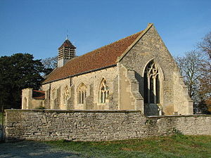
St Michael's Church, Cotham, from the southeastLocation in Nottinghamshire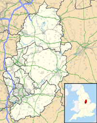
 St Michael's Church, Cotham
Coordinates: 53°01′12″N 0°49′03″W / 53.0200°N 0.8175°W OS grid reference SK 794 476 Location Cotham, Nottinghamshire Country England Denomination Anglican Website Churches Conservation Trust History Dedication Saint Michael Architecture Functional status Redundant Heritage designation Grade II* Designated 16 January 1967 Architectural type Church Style Gothic Groundbreaking 12th century Completed 1890 Specifications Materials Stone, tile roofs St Michael's Church, Cotham is a redundant Anglican church in the village of Cotham, Nottinghamshire, England. It has been designated by English Heritage as a Grade II* listed building,[1] and is under the care of the Churches Conservation Trust.[2] The church stands in an isolated position in a field, set well back from the road.[3]
Contents
History
St Michael's Church originated in the 12th century, with additions and alterations in the 14th and 15th centuries.[1] The tower and the west part of the nave were demolished in the later part of the 18th century.[2] The church was partly rebuilt in about 1832, and the bellcote was added in 1890.[1] Although it is now redundant, the church continues to be used occasionally for worship.[3] The church was declared redundant on 23 August 2004, and was vested in the Churches Conservation Trust on 19 December 1989.[4]
Architecture
Exterior
The church is constructed in coursed stone rubble with ashlar dressings, and it has a tiled roof. Its plan consists of a nave and a chancel under a single roof, a south porch, and a bellcote at the east end. The bellcote has a pyramidal roof. Along the sides of the church are buttresses. At the west end is a two-light window. The north wall contains a door and two three-light windows, and in the south wall there are four three-light windows. The east window also has three lights.[1] Some of the windows contain Decorated tracery, and in others the tracery is Perpendicular.[2] Above the entrance to the porch is a coped parapet, and a stone inscribed with 1830.[1]
Interior
Inside the church, to the east of the door is a 14th-century piscina.[1] In the west wall are five corbels. The upper two are plain and suggest the position of a former gallery. The lower three have medieval carvings of faces.[2] The font is octagonal and dates from the 14th century. Also dating from the 14th century are two memorials in the south wall that are partly hidden by the wall and the raised floor.[1]
External features
On the east side of the church is a 19th-century rubble stone wall containing iron gates and re-used 14th-century gargoyles. This is designated as a Grade II listed building.[5]
See also
- List of churches preserved by the Churches Conservation Trust in the English Midlands
References
- ^ a b c d e f g "Church of St Michael", Heritage Gateway website (Heritage Gateway (English Heritage, Institute of Historic Building Conservation and ALGAO:England)), 2006, http://www.heritagegateway.org.uk/Gateway/Results_Single.aspx?uid=242656&resourceID=5, retrieved 24 November 2010
- ^ a b c d St Michael's Church, Cotham, Nottinghamshire, Churches Conservation Trust, http://www.visitchurches.org.uk/Ourchurches/Completelistofchurches/St-Michaels-Church-Cotham-Nottinghamshire/, retrieved 29 March 2011
- ^ a b Saint Michael's Cotham, United Benefice of Farndon with Thorpe and Hawton with Cotham, http://www.farndon-hawton.org.uk/main_pages/smc.php, retrieved 24 November 2010
- ^ (PDF) Diocese of Southwell and Nottingham : All Schemes, Church Commissioners/Statistics, Church of England, 2011, p. 1, http://www.churchofengland.org/media/811136/southwell%20and%20nottingham%20-%20all%20schemes.pdf, retrieved 7 April 2011
- ^ "Wall, gates and gargoyles to Church of St Michael", Heritage Gateway website (Heritage Gateway (English Heritage, Institute of Historic Building Conservation and ALGAO:England)), 2006, http://www.heritagegateway.org.uk/Gateway/Results_Single.aspx?uid=242657&resourceID=5, retrieved 24 November 2010
Categories:- Grade II* listed buildings in Nottinghamshire
- Grade II* listed churches
- Church of England churches in Nottinghamshire
- English Gothic architecture
- 12th-century church buildings
- Churches preserved by the Churches Conservation Trust


Wikimedia Foundation. 2010.