- Church of All Saints, Martock
-
Church of All Saints 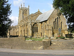
Location: Martock, Somerset, England Coordinates: 50°58′10″N 2°46′08″W / 50.96944°N 2.76889°WCoordinates: 50°58′10″N 2°46′08″W / 50.96944°N 2.76889°W Built: 13th century Listed Building – Grade I Designated: 28 April 1987[1] Reference #: 422626 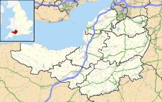
 Location of Church of All Saints in Somerset
The Church of All Saints in Martock, Somerset, England dates from the 13th century and has been designated as a Grade I listed building.[1]
The church was acquired by the Treasurer of Wells Cathedral in 1227 and he became the rector and patron of the church.[2]
The tower dates from around 1505, in four stages, with offset corner buttresses to the full height of the tower, to replace the previous one over the central crossing.[3] At the same time the rest of the church was also restored and expanded. This expansion was paid for by Lady Margaret Beaufort.[4]
In July 1645 the church was used as a billet and damaged by the troops of Oliver Cromwell after a battle at Bridgwater,[4] this included the removal of the statues of saints from niches in the clerestory.[5]
The church was restored by Benjamin Ferrey, who was architect to the Diocese of Bath and Wells from 1841 until his death, and also in 1883–84 by Ewan Christian when a new pulpit was installed. The interior includes a stucco plaster alter and an organ which was previously in Wells Cathedral.[4]
See also
- List of Grade I listed buildings in South Somerset
- List of towers in Somerset
References
- ^ a b "Church of All Saints". Images of England. English Heritage. http://www.imagesofengland.org.uk/Details/Default.aspx?id=422626. Retrieved 2009-06-07.
- ^ Leete-Hodge, Lornie (1985). Curiosities of Somerset. Bodmin: Bossiney Books. p. 81. ISBN 0906456983.
- ^ Poyntz Wright, Peter (1981). The Parish Church Towers of Somerset, Their construction, craftsmanship and chronology 1350 - 1550. Avebury Publishing Company. ISBN 0861275020.
- ^ a b c Robinson, W.J. (1915). West Country Churches. Bristol: Bristol Times and Mirror Ltd. pp. 6–10.
- ^ Wickham, A.K. (1965). Churches of Somerset. Dawlish: David & Charles. p. 35.
Categories:- Church of England churches in Somerset
- 13th-century architecture
- Grade I listed churches
- Grade I listed buildings in Somerset
- South Somerset


Wikimedia Foundation. 2010.