- Chiltern Park Aerodrome
-
Chiltern Park Aerodrome 
The wind sock at Chiltern Park IATA: none – ICAO: none Summary Airport type Private Owner Chiltern Aerosports Location Ipsden, Oxfordshire Elevation AMSL 180 ft / 55 m Coordinates 51°33′10″N 001°06′02″W / 51.55278°N 1.10056°WCoordinates: 51°33′10″N 001°06′02″W / 51.55278°N 1.10056°W Website Map Location in Oxfordshire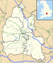
 Chiltern Park
Runways Direction Length Surface m ft 04R/22L 550 1,804 Grass 04L/22R 700 2,297 Grass 15/33 420 1,378 Grass Chiltern Park Aerodrome is a private airfield near Ipsden in Oxfordshire.[1] It is within RAF Benson's Military Aerodrome Traffic Zone.[2]
The airfield was established in 1988,[3] and caters for gyroplanes, microlights, helicopters, and gliders, as well as general aircraft.[4]
References
- ^ Action for Airfields (2003). "ALERT: Chiltern Park 12/02/01". A4A. http://www.airfields.org.uk/alerts/chiltern_010212.htm. Retrieved 12 December 2010.
- ^ "Diary". Benson Bulletin. 2009. http://www.bensonbulletin.com/diary/airamb.pdf. Retrieved 12 December 2010.
- ^ Chiltern Park Aerodrome (2010). "Airfield Info". Chiltern Airsports Ltd. http://www.chiltern.aero/page.php?page=Airfield_Info. Retrieved 12 December 2010.
Categories:- Airports in England
- Transport in Oxfordshire


Wikimedia Foundation. 2010.