- 2010 Chile earthquake
-
For other earthquakes in and about Chile during 2010, see List of earthquakes in Chile occurring in 2010.
2010 Chile earthquake 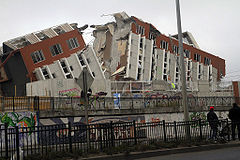
Epicenter of the 2010 Chile earthquakeDate 27 February 2010[1] Origin time 03:34 CST (UTC+03:00) Magnitude 8.8 Mw Depth 35 kilometres (22 mi)[2] or 30.1 kilometres (19 mi)[1] Epicenter [2] or [1] Countries or regions  Chile
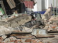
ChileMax. intensity MM VIII[3] or MM IX[1] Peak acceleration 0.65 g Tsunami Yes Casualties 525 killed, 25 missing.[4] 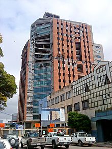 O´Higgins Tower, earthquake collapsed building, 21 floors
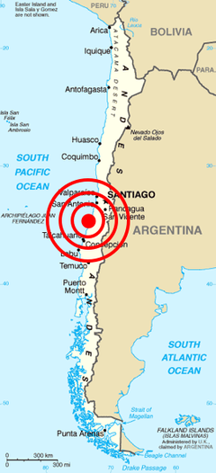
The 2010 Chile earthquake occurred off the coast of central Chile on Saturday, 27 February 2010, at 03:34 local time (06:34 UTC), having a magnitude of 8.8 on the moment magnitude scale, with intense shaking lasting for about three minutes.[5][1][2][6] It ranks as the sixth largest earthquake ever to be recorded by a seismograph. It was felt strongly in six Chilean regions (from Valparaíso in the north to Araucanía in the south), that together make up about 80 percent of the country's population. According to the United States Geological Survey (USGS) the cities experiencing the strongest shaking—VIII (Destructive) on the Mercalli intensity scale (MM)—were Arauco and Coronel. According to Chile's Seismological Service Concepción experienced the strongest shaking at MM IX (Violent).[1] The earthquake was felt in the capital Santiago at MM VII (Very Strong)[3] or MM VIII.[1] Tremors were felt in many Argentine cities, including Buenos Aires, Córdoba, Mendoza and La Rioja.[7][8] Tremors were felt as far north as the city of Ica in southern Peru (approx. 2400 km).[9] The earthquake triggered a tsunami which devastated several coastal towns in south-central Chile and damaged the port at Talcahuano. Tsunami warnings were issued in 53 countries,[10] and the wave caused minor damage in the San Diego area of California[11] and in the Tōhoku region of Japan, where damage to the fisheries business was estimated at ¥6.26 billion (USD$66.7 million).[12] The earthquake also generated a blackout that affected 93 percent of the country's population and which went on for several days in some locations.[13] President Michelle Bachelet declared a "state of catastrophe" and sent military troops to take control of the most affected areas. According to official sources, 525 people lost their lives, 25 people went missing[4] and about 9% of the population lost their homes.[14]
According to the USGS the epicenter of the earthquake was about 3 km (1.9 miles) off the coast of Pelluhue commune in the Maule Region. This is about 6 km (3.7 miles) west of the village of Chovellén, 15 km (9.3 miles) southwest of the town of Pelluhue and at a point approximately 100 km (62 miles) away from the following four provincial capitals: Talca (to the north-east), Linares (to the east), Chillán (to the south-east) and Concepción (to the south).[2] Chile's Seismological Service located the quake's epicenter at about 34 km (21 miles) off the coast of Ñuble Province in the Biobío Region. This is 60 km (37 miles) north of Concepción and 170 km (110 miles) south-west of Talca.[1]
On March 10, Swiss Reinsurance Co. estimated that the Chilean quake would cost the insurance industry between 4 and 7 billion dollars. The rival German-based Munich Re AG made the same estimate.[15] Earthquake’s losses to economy of Chile are estimated at US$15-30 billion.[16]
Contents
Seismology and geology
Main articles: Nazca Plate and geology of ChileThe earthquake took place along the boundary between the Nazca and South American tectonic plates, at a location where they converge at a rate of eighty millimeters (about three inches) a year. This earthquake was characterized by a thrust-faulting focal mechanism, caused by the subduction of the Nazca plate beneath the South American.[2]
Chile has been at a convergent plate boundary that generates megathrust earthquakes since the Paleozoic era (500 million years ago). In historical times the Chilean coast has suffered many megathrust earthquakes along this plate boundary, including the strongest earthquake ever measured, which is the 1960 Valdivia earthquake. Most recently, the boundary ruptured in 2007 causing the 2007 Antofagasta earthquake in northern Chile.
The segment of the fault zone which ruptured in this earthquake was estimated to be over 700 km (430 mi) long with a displacement of almost 10 meters.[17] It lay immediately north of the 1,000 km (620 mi) segment which ruptured in the great earthquake of 1960.[18] Preliminary measurements show that the entire South American Plate moved abruptly westward during the quake.[19] A research collaborative of Ohio State and other institutions have found, using GPS, that the earthquake shifted Santiago 11 inches (28 cm) to the west-southwest and moved Concepción at least 10 feet (at least 3 meters) to the west. The earthquake also shifted other parts of South America from the Falkland Islands to Fortaleza, Brazil. For example, it moved Argentina’s capital of Buenos Aires about one inch (2.5 cm) to the west.[20] Several cities south of Cobquecura were also raised, by up to 3 meters.[21] The maximum recorded peak ground acceleration was at Concepcion, with a value of 0.65 g (6.38 m/s2)[22]
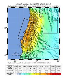 USGS shake map of the earthquake
Compared with past earthquakes
See also: Earthquakes in 2010This was the strongest earthquake affecting Chile since the magnitude 9.5 1960 Valdivia earthquake (the most energetic earthquake ever measured in the world), and it was the strongest earthquake worldwide since the 2004 Indian Ocean earthquake until the 2011 Tōhoku earthquake.[23] It is tied with the 1906 Ecuador-Colombia and 1833 Sumatra earthquakes as the sixth strongest earthquake ever measured, 501 times more forceful than the 7.0 Mw earthquake in Haiti in January of 2010.[24]
Aftershocks
An aftershock of 6.2 was recorded 20 minutes after the initial quake.[25][26] Two more aftershocks of magnitudes 5.4 and 5.6 followed within an hour of the initial quake.[26] The USGS said that "a large vigorous aftershock sequence can be expected from this earthquake".[2] By March 6 UTC, more than 130 aftershocks had been registered, including thirteen above magnitude 6.0.[27]
A 6.9-magnitude offshore earthquake struck approximately 300 kilometers southwest of, and less than 90 minutes after, the initial shock; however, it is not clear if that quake is related to the main shock.[28] A separate earthquake of magnitude 6.3 occurred in Salta, Argentina, at 15:45 UTC on February 27, at a depth of 38.2 km (23.7 mi);[29] two people were injured and one died in Salta.[30] This earthquake was followed on March 1, at 06:32 UTC by a magnitude 4.9 aftershock.[31] Four other earthquakes above M5.0, some possible aftershocks, also occurred near the border in Argentina following the Chile earthquake; a magnitude 5.0 earthquake occurred in Mendoza on February 28, a M5.3 earthquake in Neuquen and a M5.2 in San Juan on March 2, and a M5.1 quake in Mendoza on March 4.[32][33][34][35]
Another strong earthquake occurred on March 4, at 22:39 UTC in Antofagasta in northern Chile, with a magnitude of 6.3.[36]
Minor quakes generated by the main one could be felt as far away as São Paulo, Brazil,[37] located about 3,000 km (1,900 mi) away from Concepción. Since the major earthquake, and as of March 15, at least four to forty >M5.0 earthquakes have been recorded daily in the vicinity of the main earthquake,[38] including four above magnitude 6.0 between March 3 and 00:00 UTC March 6.[26]
On March 5, two aftershocks above M6.0 were reported. The first was a 6.3-magnitude off the coast of the Biobío Region. The second was near the epicenter of the original quake at 08:47 local time with a magnitude of 6.6.[39]
On March 11, the March 2010 Chile earthquake (strength 6.9, treated by some as an aftershock of the February 2010 earthquake) was reported, followed quickly by further aftershocks measuring 6.7 and 6.0. The epicenter of the 6.9 quake was in Pichilemu, O'Higgins Region.[40][41]
On March 15, two aftershocks of the February 2010 earthquake were reported, one at magnitude 6.1 at 08:08:28 local time offshore Maule,[42] and another at magnitude 6.7 with the epicenter located offshore the Biobío Region, near Cobquecura, at 23:21:58 local time.[43] This tremor was followed by two minor aftershock, one occurring 45 minutes later, measuring M5.5. No tsunami was reported and there were no tsunami warnings issued.
On March 17, at 14:38:37 local time, an earthquake of magnitude 5.2 was recorded in Aisén, in Southern Chile.[44] Another magnitude 5.2 earthquake was recorded in Los Lagos the next day. On March 26, at 10:52:06 local time, a magnitude 6.2 earthquake hit the Atacama region, in Northern Chile.[45]
The Biobio Region of Chile has had strong aftershocks of this earthquake. The first one was a magnitude 6.7 MW earthquake that struck off the coast of Biobío, Chile, at 23:21 on March 15, 2010 at the epicenter, at a depth of 18 kilometres (11 mi). The second earthquake struck on land in the region at 22:58 (UTC) on April 2, 2010 at 5.9 MW and at a depth of 39 km. The third struck on 10:03 (UTC) on April 23, 2010 at 6.2 MW.[46] The Pacific Tsunami Warning Center said that historical data indicates that this quake will not generate a tsunami but still advised of the possibility.[47] On May 3, at 19:09 an earthquake magnitude 6.4 MW struck off Biobío, Chile, at the epicenter, at a depth of 20 kilometres (12 mi). The epicenter was 55 kilometres (34 mi) south of Lebu.[48] On July 14, 2010, another 6.5 magnitude earthquake occurred in the area.
2011 aftershocks
On 2 January at 17:20:18 local time, a 7.1 magnitude aftershock occurred 70 kilometers northwest of Temuco, Chile.[49] On Lautaro, Cañete, Nueva Imperial, Traiguén and Carahue the quake was felt at intensity VI (strong) of the Mercalli scale. In Temuco it was perceived at intensity V (moderate). In Talcahuano, Concepción, Chillán, Osorno and Valdivia it shook at intensity IV (light).[50] According to the USGS the earthquake's epicenter was located on the ground, east of the coastal town of Tirúa in the Araucanía Region. However, according the University of Chile's Seismological Service, the seismic event was located 134 kilometers off the coast of Tirúa, measuring a magnitude 6.9 ML. The University of Chile also reported that the localities who received the strongest shaking (VI) were Curanilahue, Lebu and Tirúa. In Concepción, Talcahuano and Temuco it was felt at intensity V, and in Chillán and Valdivia at intensity IV.[51]
A magnitude 6.2 (;Mw) aftershock struck the coast of Biobío, Chile at a shallow depth of 15.1 km (9.4 mi) on 1 June 2011 at 08:55 local time (12:55 UTC).[52] It was centered just offshore Arauco Province near a moderately populated area, with most structures in its vicinity reported to be resistant to earthquake shaking. Strong shaking registering at VI on the Mercalli scale was felt in Lebu, just 7 km (4 ) south of the epicenter, lasting for approximately one minute.[53][54] Some residents in coastal areas panicked and evacuated their homes.[55] The earthquake was followed by a moderate magnitude 5.1 Mw tremor that occurred about 52 minutes later to the northeast of the main shock epicenter at an estimated depth of 26.9 km (16.7 mi).[56] Initial estimates from the USGS placed its intensity at a magnitude of 6.4 Mw.[57]
Geophysical impact
Seismologists estimate that the earthquake was so powerful that it may have shortened the length of the day by 1.26 microseconds and moved the Earth's figure axis by 8 cm or 2.7 milliarcseconds.[58][59] Precise GPS measurement indicated the telluric movement moved the entire city of Concepción 3.04 meters (10 ft) to the west. The capital Santiago experienced a displacement of almost 24 centimeters (10 in) west, and even Buenos Aires, about 1,350 kilometres (840 mi) from Concepción,[60] shifted 3.9 centimeters (1.5 in).[61][62] It is estimated that Chile's territory could have expanded 1.2 km² as a result.[63]
The earthquake also caused seiches to occur in Lake Pontchartrain to the north of New Orleans, United States, located nearly 7,500 kilometres (4,700 mi) from the epicenter of the quake.[64]
Damage and casualties
People were found dead after the earthquake struck, mostly under buildings and inside cars. Many people were also seriously injured. Most injuries were reported in Santiago and Maule.
According to an Associated Press Television News cameraman, some buildings collapsed in Santiago and there were power outages in parts of the city.[65] A fire was reported in a chemical plant on the outskirts of Santiago and caused the evacuation of the neighborhood.[25] Santiago's International Airport seems to have been damaged and the airport authority has closed off all flight operations for the next 24 hours from around 12:00 UTC.[5] On Sunday, February 28, Ricardo Ortega, head of the Chilean Air Force, said commercial airline services had been partially re-established and aircraft were being allowed to land in Santiago.[66]
Santiago's national Fine Arts Museum was badly damaged and did not reopen until 9 March 2010.[67] An apartment building's two-story parking lot collapsed, wrecking 68 cars. According to one health official, three hospitals in Santiago collapsed, and a dozen more south of the capital also suffered significant damage.[68]
-

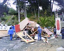
House uprooted to the streets of Pelluhue after the tsunami.
-
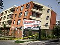
A severely damaged building in Maipú, Santiago.
-
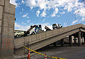
Collapsed Vespucio Norte Express Highway in Santiago.
-

Fruit Road, O'Higgins Region.
In Valparaíso, a tsunami wave of 1.29 m was reported. The port of Valparaíso was ordered to be closed due to the damage caused by the earthquake. The port started to resume limited operations on February 28.[69] In Viña del Mar, a touristic city and part of Greater Valparaíso, several buildings were structurally damaged, principally in the district Plan de Viña.[70]
Many cities in Maule region were seriously affected by the earthquake. Curanipe, only 8 km (5 mi) from the epicenter, was hit by a tsunami after the earthquake and still remained isolated from outside as of February 28.[71] A surfer said the tsunami "...was like the one in Thailand, a sudden rise of water. One could not estimate the dimension of the wave, because it was advancing foam. There were 10 to 15 rises, the last one being at 08:30 in the morning."[72] In Talca, the capital of Maule region, many dead were trapped in the rubble. The administrative building was uninhabitable, and the authorities had to be set up in the parade ground.[73] All but two of the local hospital’s thirteen wings were in ruins. Dr. Claudio Martínez was quoted as saying, “We’re only keeping the people in danger of dying.” Hospital staff attempted to transport some patients to Santiago on Sunday morning, but roads were blocked.[74]
Damaged buildings and fires were reported in Concepción.[75] Rescue teams had difficulty accessing Concepción because of the damaged infrastructure.[25] The fifteen-story residential building "Alto Río" fell backwards, horizontally lay on the ground, and trapped many of the residents. As the building was newly completed, 19 of the apartments were occupied and 36 were unknown if there were residents therein.[76][77][78] A 2.34 m (7.68 ft) tsunami wave hit Talcahuano, a port city and part of the Concepción conurbation. The tsunami caused serious damage to port facilities and lifted boats out of the water.[79] In the fishing town of Dichato, which has 7,000 residents, it was the third tsunami wave that ended up being the most damaging.[80]
Dilapidated buildings could be seen on the streets of Temuco, about 400 km (250 mi) from the epicenter. The adobe of some buildings fell. Façades fell in pieces and crushed cars. Two people were reported dead because of not having been able to escape from a nightclub. On February 27, it was reported that "to find an open business is almost impossible" ("Encontrar un negocio abierto es casi imposible").[81][82]
In Chile, 370,000 homes were damaged.[83] The final death toll of 525 victims and 25 people missing was announced by authorities in January 2011.[4]. This is down from early reports on March 3 of 802 people dead.[84]
The Chilean National Emergency Office (Oficina Nacional de Emergencia) estimated that the intensity of the earthquake was 9 on the Mercalli scale in the Biobío Region and 8 in Santiago.[25][85] USGS put the intensity in Talcahuano at MM VIII, in Santiago and Concepción at MM VII and in Valparaíso at MM VI.[3]
On March 10, Swiss Reinsurance Co. estimated that the Chilean quake would cost the insurance industry between 4 and 7 billion dollars. And this is the same estimate made by the rival German-based Munich Re AG.[15]
-

President Barack Obama holds conference call from the Situation Room of the White House concerning the earthquake in Chile.
-
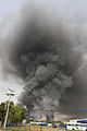
Fire at a plastics plant, Santiago, Chile.
-
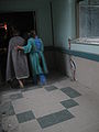
Hernán Henríquez Hospital of Temuco had to be evacuated after the earthquake.
-
A car crushed by the rubble of a collapsed building in Temuco.
Modified Mercalli intensities for some localities
Locality Country USGS[86] SS[1] Population[86] Angol ChileVII 45k Antofagasta ChileII Arauco ChileVIII 25k Buín ChileVII 55k Bulnes VII 13k Cabrero VII 18k Calama ChileII Cañete ChileVII 20k Carahue ChileVI 12k Cauquenes ChileVII 31k Chiguayante ChileVII 83k Chillán ChileVII 150k Chimbarongo ChileVII 17k Coihueco ChileVII 7k Collipulli ChileVII 16k Concepción ChileVII IX 215k Constitución ChileVII 38k Copiapó ChileIII Coquimbo ChileIII Coronel ChileVIII 93k Corral ChileIV 4k Curanilahue ChileVII 31k Curicó ChileVII 102k Cutral-Co IV 47k El Monte VII 23k Freire ChileVI 8k General Roca IV 73k Graneros ChileVII 23k Hacienda La Calera VII 49k Huayco ChileIII Illapel ChileV 23k La Laja ChileVII 17k La Ligua ChileVI 25k La Unión ChileIV 26k Lampa ChileVII 29k Las Ánimas V 30k Las Gaviotas V 2k Lautaro ChileVII 22k Lebu ChileVII 22k Limache ChileVI 36k Linares ChileVII 70k Llaillay ChileVI 17k Loncoche ChileV 16k Longaví ChileVII 6k Los Andes ChileVI 57k Los Ángeles ChileVII 125k Lota ChileVII 50k Machali ChileVI 28k Melipilla ChileVII 63k Mendoza  Argentina
IV 877k Molina ChileVII 29k Mulchén ChileVII 22k Nacimiento ChileVII 21k Neuquén ArgentinaIV 242k Nueva Imperial ChileVI 19k Osorno ChileV 136k Paine ChileVII 33k Panguipulli ChileV 16k Parral ChileVII 27k Penaflor ChileVII 66k Penco ChileVII 46k Pitrufquen ChileVI 14k Puerto Montt ChileV Quillota ChileVII 68k Quilpué ChileVII 130k Rancagua ChileVII VIII 213k Rengo ChileVII 38k Río Bueno ChileIV 15k Salamanca ChileV 13k San Antonio ChileVII 86k San Bernardo ChileVI 250k San Carlos VII 32k San Clemente ChileVII 14k San Felipe ChileVII 59k San Javier ChileVII 22k San Juan ArgentinaIV 447k San Luis IV 184k San Martín IV 83k San Rafael IV 109k San Vicente VII 23k Santa Cruz VII 33k Santiago ChileVII VIII 4,837k Talagante ChileVII 52k Talca ChileVII VIII 197k Talcahuano ChileVII 253k Temuco ChileVI VIII 238k Teno ChileVII 7k Tierra Amarilla ChileIII Tomé ChileVII 47k Traiguén ChileVII 14k Valdivia ChileV VI 133k Valparaíso ChileVII VI 282k Victoria ChileVII 25k Vicuña ChileIII-IV Vilcún ChileVI 9k Villa Alemana ChileVI 97k Villarrica ChileVII 32k Viña del Mar ChileVI VI 295k Yumbel ChileVII 11k Notes: USGS=United States Geological Survey, SS=Chile's Seismological Service.
Identified fatalities
Deaths caused by the earthquake and tsunami by region[note 1] Region 27. February[87] 28. February[88] 1. March[89] 2. March[90] 3. March[91] 4. March[92] 5. March[93] 8. March[94] Valparaíso 4 16 16 18 20 16 24 Metropolitana 13 36 38 38 38 21 23 O'Higgins 12 46 48 48 48 3 46 Maule 34 541 544 587 587 177 269 Biobio 10 64 64 92 92 56 120 Araucanía 5 5 13 13 14 6 15 National total 78 708 723 796 799 279 452 497 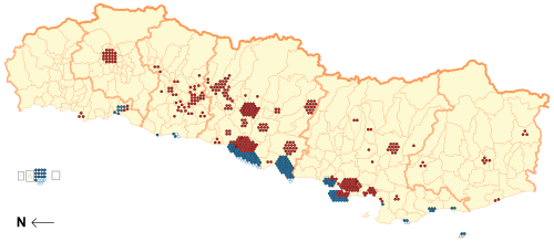
Population with destroyed or severely damaged homes
The table below shows the percentage of the population whose homes were destroyed or were severely damaged by the earthquake and tsunami in the six most affected regions. The data was collected in May and June of 2010.
Region % of pop. Valparaíso 7.4 Santiago 4.8 O'Higgins 12.2 Maule 20.7 Biobío 17.8 Araucanía 5.1 Total (six regions) 8.8 Source: Casen Post-Earthquake Survey, Ministry of Planning.
Humanitarian response
Main articles: Humanitarian response to the 2010 Chile earthquake and Timeline of relief efforts after the 2010 Chile earthquakeDespite President Michelle Bachelet's earlier statement that Chile would only ask for international aid once it had assessed the extent of the damage,[95] leaders of many countries and intergovernmental organizations, including the United Nations and European Union, responded to the earthquake and sent messages of condolence to the government and people of Chile over the loss of lives and property. Argentina, Mexico, the United States, United Kingdom, People's Republic of China, Singapore, Haiti, and Pakistan were among the countries that responded earliest following the quake.[96][97] Appeals for humanitarian aid were issued by the UK-based Oxfam, Save the Children and others.
Chilean television host Don Francisco led a telethon called Chile helps Chile with the goal of raising 15 billion pesos (about US$29 million) needed to build 30,000 emergency houses ("mediaguas"). The charity event, which ran for 24 hours in Santiago starting on Friday March 5 at 22:00, was summoned by the government and organized by several Chilean NGOs. At 23:00 on Saturday the goal was doubled, collecting 30.2 billion pesos (about US$58 million).[52]
The Chilean NGO Un Techo para Chile constructed 23,886 transitional houses for families affected by the earthquake.[98]
Conditions in the aftermath
Chaos and disorder
Nearly half the places in the country were declared "catastrophe zones", and curfews were imposed in some areas of looting and public disorder.[99] On February 28, 2010, a day after the earthquake, some affected cities were chaotic, with extensive looting of supermarkets in Concepción. Items stolen included not only food and other necessities, but also electronic goods and other durable merchandise. To control vandalism, a special force of carabineros was sent to disperse rioters with tear gas and water cannons.[100] However, despite these and other government acts (including the curfews), pillaging continued in both urban and rural areas of the affected zones.[101] Reportedly, military police arrested 160 in Concepción on March 1 and 2.[102]
 Kiosks destroyed by the tsunami in Pichilemu.
In Concepción, despite the militarization of the zone, mobs continued to steal from supermarkets and went as far as to set one store ablaze.[103] The government warned looters they would face the full weight of the law, as penalties for stealing are increased under a state of catastrophe. A week after the quake the police —tipped by neighbors— arrested three people with massive quantities of looted goods stashed in their homes. Other looted goods such as mattresses, furniture, television sets and other electronic appliances were abandoned in the streets of Concepción during the following days.[104]
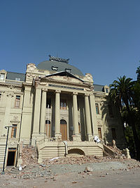 The damaged Museum of Fine Art
According to the BBC on March 5, the city and fishing port of Talcahuano, which lies but a few kilometers down the coast from Concepción, has been left largely to fend for itself. Neighbourhood vigilante groups, including one led by a public works employee with a gun license, and the few police present allow such behavior as residents' siphoning fuel from tanks at a petrol station, but step in if someone starts to attack a cash machine. One man stated, "I've personally saved dozens of people from attack in this apartment block."[105]
Chileans living in regions not affected by the earthquake (including those living abroad) also grieved, as they sought to learn more regarding kinsmen and friends affected by the earthquake. In the hardest-hit zones there was no communication with the exterior because of the failure of electricity and the destruction of telephone lines.[101]
Prison escape
In the prison of El Manzano in Concepción, a prison riot began after a failed escape attempt by the inmates. Different parts of the prison were set afire and the riot was brought under control only after the guards shot into the air and received help from military units.[106]
By March 1, prison guards in Chillán had recaptured 36 of 203 prisoners who had escaped following the earthquake. During their escape, prisoners burned seven houses close to the prison. A witness in Chillán asserted that he had been robbed by prisoners with a machine gun who had also forced his girlfriend to kiss them. Another witness alleged sexual molestation by around twenty men who were believed to be escaped prisoners. The leading Chilean newspaper El Mercurio described the situation in Chillán as reminiscent of the "Wild West".[106]
Government response
Four hours after the earthquake, when the death count was still low, President Bachelet gave a press conference in which she informed the population of the situation and stated that Chile did not yet need international aid.[95] However, about two million people were affected by the quake with more than 500,000 houses uninhabitable. In many cities, people slept in tents, in parks or simply on the streets for fear of aftershocks. The government began distributing food and other vital aid around the country.[107]
On February 28, President Bachelet said that her government had reached an agreement with the major supermarkets which would allow them to give away basic foodstuffs in stock to people affected by the earthquake.[108] By February 28, the Santiago Metro rapid-transit network was already partially up and running and expected to be fully operative on the following day, March 1.[109]
On March 4, President-elect Sebastián Piñera, who assumed office on March 11, was quoted as saying that his goals were "to cope with the emergency needs of citizens, find people who are still missing, provide prompt and timely assistance to the sick and wounded, and restore law and order so that people can return to peace."[110]
Economic recovery
Authorities of the central port city of San Antonio speaking on March 3, 2010, stated that the port had returned to eighty percent of capacity. On the same date, Raul Maturana, a spokesman for the Federation of Port Workers' union, stated that the port of Valparaíso was operating normally. However, ports in southern Chile, which were closer to the epicenter, remained closed.[111]
On March 4, President Bachelet said that Chile would need international loans and three to four years to rebuild.[112]
Food scarcity
On March 10 the National Commission for Agricultural emergencies (CNEA) assured that milk and wheat prices would not rise, despite fears of lack of fuel supply for transport and harvest of these products. In the same CNEA report the mill associations of central and southern Chile are said to have expressed that they had currently no production difficulties.[113] Despite of this in March 11 newspaper La Segunda cited the president of the bakeries association complaining on unjustified price rises for flour, who said of cases of price rises of 10 to 20%.[114]
The earthquake affected production at the Compañía de Cervecerías Unidas (CCU) and Cervecería Chile factories that together have a 90% share of the Chilean beer market. With an average annual per capita consumption of 36 liters, scarcity caused prices to rise from 990-1500 to 2000 Chilean pesos per litre. CCU responded by increasing capacity of their plant in Temuco that did not suffer major damage during the earthquake and by importing beer from their factories in Argentina. 50 trucks with beer are reported to have reached Santiago from Argentina. In March 2010, ten CCU executives said that the country will not run out of beer and that within two to three months production levels would be normalized.[115] Liquor store owners expressed complaints regarding CCU's beer rationing. The scarcity favoured consumption of "premium beers" like Kunstmann and Paceña.[116]
Tsunami
A tsunami warning was first declared for Chile and Peru,[117] and a tsunami watch for Ecuador, Colombia, Antarctica, Panama and Costa Rica.[118][119] The warning was later extended to a Pacific Ocean-wide warning, covering all coastal areas on the Pacific Ocean except the west coast of the United States, British Columbia, and Alaska.[120] Hawaiian media reported that tsunami warning sirens first sounded at 06:00 local time.[121] The U.S. Tsunami Warning Center issued advisories about potential tidal waves of less than 1 m (3 ft 3 in) striking the Pacific Ocean coastline between California and most of Alaska late in the afternoon or through the evening 12 or more hours after the initial earthquake.[122] Although the earthquake killed far fewer people than the Haitian earthquake less than 7 weeks prior, it was still devastating. The tsunami warning was cancelled for all countries except Japan and Russia in PTWC Bulletin 18 of 00:12 UTC on 28 February 2010.[123]
In general, tsunamis tend to come in several waves, of which the first may not be the highest.[124][125]
 The tsunami's passage as recorded by National Data Buoy Center Deep-ocean Assessment and Reporting of Tsunamis (DART) buoy 34142, located in the southeastern Pacific Ocean 630 nautical miles (1170 km) southwest of Lima, Peru.
The U.S. National Weather Service's Pacific Tsunami Warning Center issued a tsunami warning throughout a huge swathe of the Pacific region, including Antarctica.[126] In the Americas, the warning extended to Chile (including Easter Island), Colombia, Costa Rica, Ecuador, El Salvador, Guatemala, Mexico, and Panama.[126] A warning was also issued for the Oceania and Pacific Islands nations and territories of American Samoa, Australia, the Cook Islands, the Federated States of Micronesia (including the FSM states of Chuuk, Kosrae, Pohnpei and Yap), Fiji, French Polynesia, Guam, Hawaii, Jarvis Island, Johnston Island, the Kermadec Islands, Kiribati, Marcus Island, the Marshall Islands, Midway Island, New Caledonia, New Zealand, Niue, the Northern Mariana Islands, Palau, Papua New Guinea, Pitcairn Islands, Samoa, the Solomon Islands, Tokelau, Tonga, Tuvalu, Wallis and Futuna and Wake Island.[126] Tsunami warnings were also in effect as far away as East and Southeast Asia including Japan, Indonesia, the Philippines, Russia and Taiwan.[126]
Coastal areas of Canada's westernmost province British Columbia was under a tsunami advisory.[127] No large wave was expected to strike British Columbia, but strong local ocean currents combined with a wave put low-lying coastal regions at risk of flooding.[127] The first wave was expected to reach southern British Columbia at 15:11 local time.[127] Residents were advised to avoid beaches, harbours and marinas.[128]
A tsunami advisory was also issued for coastal areas of California, Oregon, Washington and southern Alaska in the United States.[129] This tsunami advisory was canceled as of 07:13 UTD on February 28.[130]
Russian authorities lifted a tsunami alert for the Kamchatka coast, after the arrival of a 0.8 m (2.6 ft) surge that caused no damage.[131] The tsunami was also reported to be small along the Japanese coast, and passed without incident. Many coastal areas in Japan had been evacuated as a precaution.[132]
The projections use DART (Deep-ocean Assessment and Reporting of Tsunamis) gauges spread along the sea floor, which is a fairly new technology. Initial deep sea readings showed wave height of 25 centimeters, which is huge for deep water according to Gerard Fryer of the Pacific Tsunami Warning Center. He went on to say, “although it was huge, we didn't quite know what it meant because we haven't much experience with those. As we get more under our belts, we'll get better."[133]
Chile

Some 30 minutes after the first shock, consecutive tsunamis hit coastal towns, among which Constitución suffered the hardest damage;[134] subsequently, a tsunami amplitude of up to 2.6 m (8 ft 6 in) high was recorded in the sea at Valparaíso.[25][135][136] A wave amplitude of 2.34 m (7.68 ft) was recorded at Talcahuano in the Biobío Region.[137] Robinson Crusoe Island, the largest of the Juan Fernández Islands, was struck by a large wave led to the deaths of four people on the island, with eleven people reported as missing, according to Provincial Governor Ivan De La Maza. President Bachelet is reported to have sent an aid mission to the remote island.[138][139]
As a precaution against the coming tsunami, partial evacuation was ordered in Easter Island, about 3,510 km (2,180 mi) away from the coast of Chile. The tsunami wave arrived in Easter Island at 12:05 UTC, measuring 0.35 m (1.15 ft).[140][141]
On 27 February, defense minister Francisco Vidal said that the Chilean Navy had made a mistake by not immediately issuing a tsunami warning after the earthquake, a step that could have helped coastal villagers flee to higher ground sooner. However, an alarm was later sounded by port captains and saved some lives.[142] The head of Chile's oceanographic service SHOA, which is part of the country's navy, was later fired for the organization's failure to provide clear warnings about the tsunami.[143]
Oceania
- New Zealand
Initially, the New Zealand Ministry of Civil Defence and Emergency Management (CDEM) said they did not expect a tsunami to reach New Zealand,[144] but later issued a warning stating that waves of up to 1 m (3 ft 3 in) high were likely for the eastern[145] and later the entire New Zealand coast.[146] By 19:55 UTC (08:40 local), CDEM reported wave activity of 50 cm (1.6 ft) in the Chatham Islands,[147] and 2 m (6 ft 7 in) surges were reported there later in the morning.[148] A surge 2.2 m (7 ft 3 in) high hit the South Island's Banks Peninsula,[146][149] while surges up to 1 m (3 ft 3 in) high were reported in the northern North Island.[150] By mid afternoon (local time), Civil Defence had downgraded the tsunami warning to an alert, while still advising that sea levels could change quickly for up to 24 hours from the initial surge.[151]
- Antarctica
The U.S. Antarctic Program's coastal station along the Antarctic Peninsula, Palmer Station, went on a tsunami alert shortly after the earthquake struck Chile. To prepare for a possible tsunami, station personnel removed all Zodiac boats from the water and moved any materials from low-lying areas that waves could have swept away. Personnel also retreated to the station’s highest building, GWR, while the tsunami warning was in effect, Ellis said. Palmer personnel developed a tsunami emergency plan following the 2004 earthquake in the Indian Ocean that created a tsunami that killed more than 230,000 people in 14 countries. While no noticeable tsunami occurred at Palmer, the station tide monitor displayed bumps of several centimeters, signifying that a small wave had indeed reached the shores of Anvers Island.[152]
- Australia
The Joint Australian Tsunami Warning Center (JATWC) sent out tsunami warnings for New South Wales, Queensland, Lord Howe Island, Norfolk Island, Tasmania, and Victoria. The organization warned of the possibility of dangerous waves, strong ocean currents and foreshore flooding to occur on the east coast of Australia for several hours on Sunday.[153] As a result of the warnings, patrolled beaches in New South Wales and Queensland remained closed (red flags) and lifeguards ushered people to leave the water. However beach goers and surfers ignored the warnings. Numerous onlookers also crowded parts of the shore to view potential effects of the tsunami.[154] The beach ban was lifted by the end of the day and there was no reports of damage, flooding or other emergencies. Tsunami waves of between 10 cm and 50 cm were recorded and their surges were believed to have created strong currents. Increases in sea levels include: Norfolk Island 50 cm, Gold Coast (Qld) 20 cm, Port Kembla (NSW) 14 cm, Southport (Tas) 17 cm.[154]
- French Polynesia
A wave measuring up to 6 ft (1.8 m) high struck portions of French Polynesia between 15:50 to 17:50 UTC with no reports of injuries as of February 28, 2010[update].[155] A wave 4 meters high is reported to have struck Hiva Oa in the Marquesas Islands.[156] The first waves were expected to hit the main island of Tahiti at approximately 16:50 UTC (07:50 local).[157] Cars and other automobiles were banned from roads closer than 500 m (1,600 ft) from the Pacific Ocean.[157]
Réseau France Outre-mer in Papeete reported that a wave measuring less than 1 m (3 ft 3 in) passed east of the Gambier Islands with no damage, according to Monique Richeton, the mayor of Rikitea.[155][157] Residents of the Tuamotus, which are low-lying, were told to move to the highest points on the island.[157]
- American Samoa
The first wave was expected to reach American Samoa, which is still recovering from the 2009 Samoa earthquake and tsunami, at 08:51 local time.[157] Lieutenant Governor Ipulasi Aitofele Sunia urged residents not to rush to A'oloau, a high elevation area on Tutuila, as it could cause traffic jams, putting safety at risk.[157] Many coastal towns, including the main city of Pago Pago, had already been heavily damaged in the 2009 tsunami. The first wave arrived on Pago Plaza at 21:58 UTC.
- Philippines
The Philippine Institute of Volcanology and Seismology (Phivolcs) issued an advisory that tsunami wave(s) were expected to hit the eastern coast of the Philippines on Sunday between 05:00 and 06:30 UTC (13:00 and 14:30 local). Residents of 19 eastern provinces "are advised to prepare for possible evacuation."[158] However, at 15:15 on February 28, 2010, all warnings have been cancelled.[159]
- Hawaii
United States Senators Daniel Inouye and Daniel Akaka issued a joint press release announcing the first tsunami evacuation in Hawaii since 1994.[160][161] Warning sirens were sounded throughout the state, as hotels in Waikiki evacuated tourists at 6 a.m. People in tall buildings were encouraged to move above the third floor. Waves measuring nine feet high were originally predicted to strike Hilo Bay on the Big Island of Hawai'i at 11:05 local time (21:05 GMT),[162] but by 11:18, major receding and waves had not been reported on the shoreline. By 11:40, several waves hit the islands amounting to raising and lowering of the sea near the coast, and a fourth wave hit around 13:12. The tsunami warning for Hawaii was canceled in the early afternoon on Saturday, February 27.
Gerard Fryer, a geophysicist for the Pacific Tsunami Warning Center was quoted as saying: “We expected the waves to be bigger in Hawaii, maybe about 50 percent bigger than they actually were."[163] Early in the morning, the Center expected waves of 10 feet. In actuality, the highest tsunami waves ended up being about 5 to 6 feet peak to trough.[133]
North America
- British Columbia
At around 23:00 UTC (15:00 local), a tsunami warning was issued for coastal British Columbia. Extra precautions were already in place due to the 2010 Winter Olympics being held in Vancouver at the time.[164]
- California
Small waves were expected in Southern California, and receding was reported at Long Beach. Minor damage was reported on some coastal areas. The tsunami damaged navigation buoys at Ventura.[165] Additionally, a boat was torn loose from its mooring and minor erosion occurred within Ventura Harbor. Damage to docks and pilings in the area was moderate.[166]
- Guerrero
In Guerrero, surges of between 30 cm and 1 meter and receding of up to 10 m were reported, and three small vessels were sunk at Tecpán de Galeana. The state tourism authorities announced they would be sending a letter to the CNN news network to protest the "alarming" way in which it had forecast a tsunami for the major tourist destination of Acapulco.[167]
Argentina has sent construction teams to Chiloé Island to help reconstruct some of the washed away coastal buildings. In July 2010, the government of Argentina released a statement that they would lend $300 million to Chile for reconstruction efforts using Argentine goods.[168]
Data
The following data, published by the Pacific Tsunami Warning Center and the West Coast and Alaska Tsunami Warning Center, lists measured and reported values of the tsunami when it arrived at specific places. Some data is taken from the Chilean Army.
Tsunami arrival data[137][169][170] Station Country or territory Latitude Longitude Time (UTC) Height (m) Height (ft) Pichilemu Chile34.23 S 72.0 W 06:48 3.02 10.0 Talcahuano Chile36.9 S 75.4 W 06:53 2.34 7.7 Valparaíso Chile33 S 71.6 W 07:08 1.29 4.2 Corral Chile39.9 S 73.4 W 07:39 0.90 2.9 San Felix Chile26.3 S 80.1 W 08:15 0.53 1.7 Caldera Chile27.1 S 70.8 W 08:34 0.45 1.5 Ancud Chile41.9 S 73.8 W 08:38 0.62 2.0 Coquimbo Chile30 S 71.3 W 08:52 1.32 4.3 Iquique Chile20.2 S 70.1 W 09:07 0.28 0.9 DART Lima  Peru
Peru18 S 86.4 W 09:41 0.24 0.8 Antofagasta Chile23.2 S 70.4 W 09:41 0.49 1.6 Arica Chile18.5 S 70.3 W 10:08 0.94 3.1 Callao Peru12.1 S 77.2 W 10:29 0.36 1.2 Easter Island Chile27.2 S 109.5 W 12:05 0.35 1.1 Quepos  Costa Rica
9.45 N 84.15 W 14:16 0.24 0.8 Galapagos Islands  Ecuador
0.4 S 90.3 W 14:52 0.35 1.2 DART Marquesas Islands  French Polynesia
8.5 S 125 W 15:31 0.18 0.6 Rikitea French Polynesia23.1 S 134.9 W 15:59 0.15 0.5 DART Manzanillo 16.0 N 107 W 16:11 0.07 0.2 Manzanillo  Mexico
19.1 N 104.3 W 17:05 0.32 1.0 Hiva Oa French Polynesia9.8 S 139.0 W 17:41 1.79 5.9 Nuku Hiva French Polynesia8.9 S 140.1 W 17:45 0.95 3.1 Papeete French Polynesia17.5 N 149.6 W 18:10 0.16 0.5 Cabo San Lucas Mexico22.9 N 109.9 W 18:33 0.36 1.2 Rarotonga  Cook Islands
21.2 S 159.8 W 19:07 0.15 0.5 Acapulco Mexico16.8 N 99.9 W 19:31 0.62 2.0 DART San Diego 32.2 N 120.7 W 19:31 0.06 0.2 Lottin Point  New Zealand
37.6 S 178.2 E 19:34 0.15 0.5 DART Tonga 23 S 168.1 W 20:03 0.04 0.1 Apia  Samoa
Samoa13.8 S 171.8 W 20:18 0.13 0.4 Nukualofa  Tonga
Tonga21.1 S 175.2 W 20:24 0.1 0.3 Pago Pago  American Samoa
14.3 S 170.7 W 20:27 0.22 0.7 Monterey, California  United States
36.6 N 121.9 W 20:31 0.28 1.1 San Diego, California United States32.7 N 117.2 W 20:36 0.13 0.4 San Francisco, California United States37.8 N 122.5 W 21:20 0.26 0.8 Hilo, Hawaii United States19.7 N 154.9 W 21:20 0.86 2.8 Kuamalapau, Hawaii United States20.8 N 156.9 W 21:36 0.18 0.6 Kahului, Hawaii United States20.9 N 156.5 W 21:47 0.98 3.2 Santa Barbara, California United States34.4 N 119.7 W 21:50 0.53 1.7 Barber's Point, Hawaii United States21.3 N 158.1 W 21:57 0.12 0.4 Honolulu, Hawaii United States21.3 N 150.4 W 22:00 0.25 0.8 Kawaihae, Hawaii United States20 N 155.5 W 22:11 0.52 1.7 Crescent City, California United States41.7 N 124.2 W 22:13 0.37 1.2 Vanuatu  Vanuatu
17.8 S 168.3 E 22:46 0.15 0.5 Johnston Atoll United States16.7 N 169.5 W 22:48 0.22 0.7 Nawiliwili, Hawaii United States22 N 159.4 W 23:23 0.37 1.2 Sitka, Alaska United States57.1 N 135.3 W 00:11 28 Feb 0.08 0.3 Guam  Guam
Guam13.4 N 144.7 E 03:07 0.16 0.5 Minamitorishima[171]  Japan
Japan24.1N 153.5E 03:43 0.1 0.3 DART Saipan 19.1 N 155.8 E 03:55 0.08 0.3 Otsuchi, Iwate[citation needed] Japan39.21 N 141.54 E 06:43 1.45 4.35 Yamada, Iwate[citation needed] Japan39.47 N 141.95 E 08:14 1.61 4.85 Hachinohe, Aomori[citation needed] Japan40.30 N 141.29 E 08:44 0.9 2.7 Nemuro, Hokkaido[citation needed] Japan43.20 N 145.35 E 09:23 1.0 3.0 Kuji, Iwate[citation needed] Japan40.11 N 141.46 E 10:01 1.2 3.6 Susaki, Kochi[citation needed] Japan33.24 N 133.17 E 10:42 1.2 3.6 Shibushi, Kagoshima[citation needed] Japan31.30 N 131.03 E 10:56 1.0 3.0 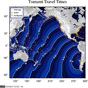 Tsunami ETA NOAA (hour 0=06:34 UTC Feb 27)
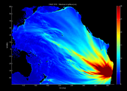 The energy model map of the tsunami.
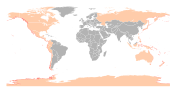 Countries with coastal areas that were at risk (in pink).
See also
- 2010 Pichilemu earthquake
- 2010 Haiti earthquake
- 03:34: Earthquake in Chile
- March 2010 Chile blackout
- List of earthquakes in Chile
- Seismicity of the Chilean coast
- 2011 Puyehue eruption
- List of 21st century earthquakes
- List of largest earthquakes by magnitude
Notes
- ^ The numbers were given by Chilean National Emergency Office (ONEMI) until 3. March. Up 14. March the Ministry of the Interior (Chile).
References
- ^ a b c d e f g h i "Chile's seismological office". Sismologia.cl. 2010-02-27. http://www.sismologia.cl/events/sensibles/2010/02/20100227063428.html. Retrieved 2011-03-23.
- ^ a b c d e f "USGS Earthquake Details". United States Geological Survey. http://earthquake.usgs.gov/earthquakes/eqinthenews/2010/us2010tfan/. Retrieved February 27, 2010.
- ^ a b c "PAGER–M 8.8–OFFSHORE MAULE, CHILE". Earthquake.usgs.gov. http://earthquake.usgs.gov/earthquakes/pager/events/us/2010tfan/index.html. Retrieved February 27, 2010.
- ^ a b c Subsecretaría del Interior de Chile (January 31 2011). «Informe final de fallecidos y desaparecidos por comuna»
- ^ a b "Reuters earthquake report". Reuters. June 10, 2010. http://www.reuters.com/article/idUSTRE61Q0S920100227. Retrieved February 27, 2010.
- ^ "Science Highlights 2010 - UNAVCO Event Response - Mw=8.8 Chile Earthquake Feb. 27, 2010". UNAVCO. http://www.unavco.org/community_science/science_highlights/2010/M8.8-Chile.html. Retrieved 2011-03-23.
- ^ "Confirman que el sismo de Chile se sintió en Buenos Aires" (in Spanish). Infobae. February 27, 2010. http://www.infobae.com/general/502937-101275-0-Confirman-que-el-sismo-Chile-se-sinti%C3%B3-Buenos-Aires. Retrieved 27 February 2010.
- ^ "En la región de Cuyo "se sintió muy fuerte" el temblor de Chile". Infobae.com. February 27, 2010. http://www.infobae.com/general/502942-101275-0-En-la-regi%C3%B3n-Cuyo-se-sinti%C3%B3-muy-fuerte-el-temblor-Chile. Retrieved February 27, 2010.
- ^ Peru.com. February 27, 2010. http://www.peru.com/noticias/portada20100227/83441/Temblor-sacude-Ica-y-causa-temor-en-pobladores-tras-terremoto-en-Chile-. Retrieved February 27, 2010.
- ^ "Tsunami After Major Earthquake Hits Chile". Sky News. February 27, 2010. http://news.sky.com/skynews/Home/World-News/Chile-Earthquake-Measuring-83-On-The-Richter-Scale-Hits-Concepcion-And-Capital-Santiago/Article/201002415561008?lpos=World_News_Carousel_Region_0&lid=ARTICLE_15561008_Chile%3A_Earthquake_Measuring_8.3_On_The_Richter_Scale%2C_Hits_Concepcion_And_Capital_Santiago. Retrieved February 27, 2010.
- ^ "Magnitude 8.8 - OFFSHORE BIO-BIO, CHILE". Earthquake.usgs.gov. http://earthquake.usgs.gov/earthquakes/recenteqsww/Quakes/us2010tfan.php#summary. Retrieved 2011-03-11.
- ^ Fisheries took ¥6 billion hit from Chile tsunami, Japan Times'. March 28, 2010.
- ^ "Apagón en el SIC del 27 de Febrero de 2010". Cdec-sic.cl. https://www.cdec-sic.cl/noticia_en.php?noticia_id=842. Retrieved 2011-03-11.
- ^ Casen Post-Earthquake Survey, Ministry of Planning.
- ^ a b Swiss Re puts Chile quake insurance cost at $4-7BN, Associated Press, March 10, 2010.
- ^ UNEP Year Book2011, An Overview of Our Changing Environment, United Nations Environment Programme 2011 page 2
- ^ "Chile Earthquake | Magnitude 8.8". British Geological Survey. 2010-02-27. http://www.bgs.ac.uk/research/highlights/chileearthquakeFeb2010.html. Retrieved 2011-03-11.
- ^ Fountain, Henry (February 27, 2010). "Underwater Plate Cuts 400-Mile Gash". The New York Times. http://www.nytimes.com/2010/02/28/world/americas/28quake.html. Retrieved February 27, 2010.
- ^ "Researchers show how far South American cities moved in quake, Research News, Ohio State University, March 8, 2010". Researchnews.osu.edu. http://researchnews.osu.edu/archive/chilemoves.htm. Retrieved 2011-03-23.
- ^ "Chile earthquake moved city of Concepcion 10ft to the west". The Daily Telegraph (London). March 9, 2010. http://www.telegraph.co.uk/news/worldnews/southamerica/chile/7403578/Chile-earthquake-moved-city-of-Concepcion-10ft-to-the-west.html.
- ^ van der Horst, Loretta (21 April 2010). "Satellite Images Show That Talcahuano “Grew” 1.5 Meters Higher As A Result Of Earthquake". Santiago Times. http://www.santiagotimes.cl/index.php?option=com_content&view=article&id=18655. Retrieved 1 May 2010.
- ^ Araneda, J.C.; Rudnick, H (October 2010). "Lessons from the 2010 Chilean earthquake and its impact on electricity supply". 2010 International Conference on Power System Technology. http://www.ece.unm.edu/~kevinwang/ChileEarthquakeElectricity2010.pdf. Retrieved 9 March 2011.
- ^ "Historic World Earthquakes". Earthquake.usgs.gov. United States Geological Survey. November 23, 2009. http://earthquake.usgs.gov/earthquakes/world/historical_mag.php. Retrieved February 27, 2010.
- ^ "Chile-Haiti Earthquake Comparison: Chile Was More Prepared". TheHuffingtonPost.com. 2 maj 2011. http://www.huffingtonpost.com/2010/02/27/chile-haiti-earthquake-co_n_479705.html.
- ^ a b c d e "Massive earthquake strikes Chile", BBC News, 28 February 2010, http://news.bbc.co.uk/2/hi/in_depth/8540289.stm
- ^ a b c Latest Earthquakes M5.0+ in the World, by USGS.
- ^ USGS, Earthquake Hazards Program (March 6, 2010). "10-degree Map Centered at 35°S,75°W". United States Geological Survey. http://earthquake.usgs.gov/earthquakes/recenteqsww/Maps/10/285_-35.php. Retrieved 6 March 2010.
- ^ USGS, Earthquake Hazards Program (February 27, 2010). "Magnitude 6.9 - Off the coast of Bio-Bio, Chile". United States Geological Survey. http://earthquake.usgs.gov/earthquakes/recenteqsww/Quakes/us2010tfa7.php. Retrieved February 27, 2010.[dead link]
- ^ USGS, Earthquake Hazards Program (February 27). "Magnitude 6.3–SALTA, Argentina". United States Geological Survey. http://earthquake.usgs.gov/earthquakes/recenteqsww/Quakes/us2010tfc3.php. Retrieved 27 February 2010.[dead link]
- ^ "Chile's earthquake death toll rises to 214". News.xinhuanet.com. http://news.xinhuanet.com/english2010/world/2010-02/28/c_13191160.htm. Retrieved 2010-03-01.
- ^ USGS, Earthquake Hazards Program (March 1). "Magnitude 4.9–SALTA, Argentina". United States Geological Survey. http://earthquake.usgs.gov/earthquakes/recenteqsww/Quakes/us2010thaz.php. Retrieved 6 March 2010.[dead link]
- ^ USGS, Earthquake Hazards Program (February 28). "Magnitude 5.0–MENDOZA, Argentina". United States Geological Survey. http://earthquake.usgs.gov/earthquakes/recenteqsww/Quakes/us2010tgbr.php. Retrieved 6 March 2010.[dead link]
- ^ USGS, Earthquake Hazards Program (March 2). "Magnitude 5.3–NEQUEN, Argentina". United States Geological Survey. http://earthquake.usgs.gov/earthquakes/recenteqsww/Quakes/us2010tkbp.php. Retrieved 6 March 2010.[dead link]
- ^ USGS, Earthquake Hazards Program (March 2). "Magnitude 5.2–SAN JUAN, Argentina". United States Geological Survey. http://earthquake.usgs.gov/earthquakes/recenteqsww/Quakes/us2010tick.php. Retrieved 6 March 2010.[dead link]
- ^ USGS, Earthquake Hazards Program (March 4). "Magnitude 5.1–MENDOZA, Argentina". United States Geological Survey. http://earthquake.usgs.gov/earthquakes/recenteqsww/Quakes/us2010tkbp.php. Retrieved 6 March 2010.[dead link]
- ^ USGS, Earthquake Hazards Program (March 4, 2010). "Magnitude 6.3 - ANTOFAGASTA, Chile". United States Geological Survey. http://earthquake.usgs.gov/earthquakes/recenteqsww/Quakes/us2010tkcs.php. Retrieved 6 March 2010.[dead link]
- ^ "Estado de SP sente reflexo do terremoto de 8,8 graus registrado no Chile" (in Portuguese). Folha Online. February 27, 2010. http://www1.folha.uol.com.br/folha/cotidiano/ult95u699876.shtml. Retrieved February 27, 2010.
- ^ "Latest Earthquakes in the World - Past 7 days". http://earthquake.usgs.gov/earthquakes/recenteqsww/Quakes/quakes_all.php. Retrieved Mar 5, 2010.
- ^ "Strong aftershocks rattle Chile". CNN.com. February 28, 2010. http://www.cnn.com/2010/WORLD/americas/03/05/chile.earthquake/index.html. Retrieved 2010-03-05.
- ^ Forero, Juan (March 12, 2010). "Aftershocks a reality check for Chilean President Sebastián Piñera". The Washington Post. http://www.washingtonpost.com/wp-dyn/content/article/2010/03/11/AR2010031104761.html.
- ^ Magnitude 6.9 LIBERTADOR O HIGGINS, CHILE, U.S. Geological Survey, Thurs., March 11, 2010, 11:39:44 at epicenter. This 6.9 aftershock/new earthquake (depending on how one looks at it) had an epicenter at 34.259 S, 71.929 W.
- ^ <Magnitude 6.1 - OFFSHORE MAULE, CHILE[dead link]
- ^ Magnitude 6.7 BÍO-BÍO, CHILE, U.S. Geological Survey, Tuesday, Monday, March 15, 2010 at 23:21:59 at epicenter (36.124S 73.147W, 18.0 kilometers depth).
- ^ Magnitude 5.2 - AISEN, CHILE[dead link]
- ^ Earthquakes, USGS (March 26, 2010). "Magnitude 6.2 - ATACAMA, CHILE". Earthquake Hazards Program. United States Geological Survey. http://earthquake.usgs.gov/earthquakes/recenteqsww/Quakes/us2010uhay.php. Retrieved 26 March 2010.[dead link]
- ^ "Magnitude 6.7 - OFFSHORE BIO-BIO, CHILE". USGS. 2010-03-26. http://earthquake.usgs.gov/earthquakes/eqinthenews/2010/us2010txai/#details. Retrieved 2010-03-27.
- ^ "Aftershock hits off coast of Chile, no damage". Reuters. 2010-03-15. http://www.reuters.com/article/idUSTRE62F0DC20100316. Retrieved 2010-03-27.
- ^ "Magnitude 6.4 - OFFSHORE BIO-BIO, CHILE". USGS. 2010-05-03. http://earthquake.usgs.gov/earthquakes/recenteqsww/Quakes/us2010vvcg.php. Retrieved 2010-05-03.[dead link]
- ^ "Magnitude 7.1 - ARAUCANIA, CHILE". Earthquake.usgs.gov. http://earthquake.usgs.gov/earthquakes/recenteqsww/Quakes/usc0000y49.php#details. Retrieved 2011-03-11.
- ^ "PAGER - M 7.1 - ARAUCANIA, CHILE". Earthquake.usgs.gov. http://earthquake.usgs.gov/earthquakes/pager/events/us/c0000y49/index.html. Retrieved 2011-03-11.
- ^ "Informe de Sismo". Sismologia.cl. http://www.sismologia.cl/events/sensibles/2011/01/20110102201957.html. Retrieved 2011-03-11.
- ^ a b "Magnitude 6.2 – Offshore Bio-Bio, Chile". USGS. 2011-06-01. http://earthquake.usgs.gov/earthquakes/recenteqsww/Quakes/usc0003wdc.php. Retrieved 2011-06-01.
- ^ "PAGER - Magnitude 6.2 – Offshore Bio-Bio, Chile". USGS. 2011-06-01. http://earthquake.usgs.gov/earthquakes/pager/events/us/c0003wdc/index.html. Retrieved 2011-06-01.
- ^ (Spanish) "Sismo 6,4 Richter afectó a 4 regiones de Chile: Desde el Maule a Los Ríos". La Nación. 2011-06-01. http://www.lanacion.cl/sismo-6-4-richter-afecto-a-4-regiones-de-chile-desde-el-maule-a-los-rios/noticias/2011-06-01/091836.html. Retrieved 2011-06-01.
- ^ AFP (2011-06-01). "Strong 6.4 magnitude quake shakes Chile". Google Hosted News. http://www.google.com/hostednews/afp/article/ALeqM5j9GLZ4LcoGpD87c0v-P6BDRhsfKw. Retrieved 2011-06-01.
- ^ "Magnitude 5.1 – Bio-Bio, Chile". USGS. 2011-06-01. http://earthquake.usgs.gov/earthquakes/recenteqsww/Quakes/usc0003wdz.php. Retrieved 2011-06-01.
- ^ NEIC (2011-06-01). "Magnitude 6.4 offshore Bio-Bio, Chile". USGS. http://www.webcitation.org/5z7PgvXTY. Retrieved 2011-06-01.
- ^ "NASA - Chilean Quake May Have Shortened Earth Days". Nasa.gov. 2010-03-01. http://www.nasa.gov/topics/earth/features/earth-20100301.html. Retrieved 2011-03-11.
- ^ "Earth days could be shorter after Chilean earthquake". News.com.au. 2009-07-22. http://www.news.com.au/features/earth-days-could-be-shorter-after-chilean-earthquake/story-e6frflor-1225836120460. Retrieved 2010-03-02.
- ^ "Cities located close to Buenos Aires". timeanddate.com. http://www.timeanddate.com/worldclock/distances.html?n=51. Retrieved 13 March 2010.
- ^ Mason, Betsy (2010-03-08). "Chile earthquake moved entire city 10 feet to the west". Dailycaller.com. http://dailycaller.com/2010/03/08/chile-earthquake-moved-entire-city-10-feet-to-the-west/. Retrieved 2011-03-23.
- ^ Researchers Show How Far South American Cities Moved In Quake. Retrieved March 9, 2010.
- ^ Chile ¨Grows” 1.2 Square Kilometers As A Result Of February 27 Earthquake, The Santiago Times, May 12, 2010.
- ^ Erdman, Jonathan (February 27, 2010). "How strong & rare was quake?". The Weather Channel. http://www.weather.com/outlook/weather-news/news/articles/0227-quake-perspective_2010-02-27. Retrieved 27 February 2010.
- ^ Vergara, Eva, "8.8-magnitude earthquake hits central Chile", Associated Press, http://news.yahoo.com/s/ap/20100227/ap_on_re_la_am_ca/lt_chile_earthquake_9, retrieved 27 February 2010[dead link]
- ^ Franklin, Jonathan; Gabbatt, Adam (March 1, 2010). "Chilean military takes control of quake-hit cities". The Guardian (London). http://www.guardian.co.uk/world/2010/mar/01/chile-military-earthquake-cities-looting.
- ^ "Información al visitante" (in Spanish). http://www.dibam.cl/bellas_artes/contenido.asp?id_contenido=798&id_submenu=1241&id_menu=18. Retrieved 10 March 2010. "Museo Nacional de Bellas Artes agradece las expresiones de apoyo y comprensión luego del terremoto que afectó su funcionamiento durante la semana pasada. Nos complace informar que reabriremos nuestras puertas el martes 9 de marzo en horario habitual."
- ^ "Massive quake hits Chile, triggers tsunami". MSNBC. 27 February 2010. http://www.msnbc.msn.com/id/35615455/ns/world_news-chile_earthquake/. Retrieved 27 February 2010.
- ^ Soto, Alonso (March 1, 2010), "Chile ports resume operations after quake--union", Reuters, http://uk.reuters.com/article/idUKN01241664._CH_.2420
- ^ "Esperan entrega de estudios estructurales de departamentos dañados en Viña", El Observador, March 4, 2010, http://diarioelobservador.cl/1951-Esperan_entrega_de_estudios_estructurales_de_departamentos_da_ntilde_ados_en_Vi_ntilde_a.html (Spanish).
- ^ "index". Lasegunda.com. 2006-09-29. http://www.lasegunda.com/ediciononline/cronica/detalle/index.asp?idnoticia=541275. Retrieved 2010-03-01.
- ^ "Surfista que sobrevivió en Curanipe: El maremoto se pareció al que hubo en Tailandia". Cooperativa.cl. http://www.cooperativa.cl/surfista-que-sobrevivio-en-curanipe--el-maremoto-se-parecio-al-que-hubo-en-tailandia/prontus_nots/2010-02-28/205555.html. Retrieved 2010-03-01.
- ^ "Ansalatina - CHILE: MAS DE 30 MUERTOS EN TALCA". ansa.it. http://www.ansa.it/ansalatina/notizie/notiziari/chile/20100227145035036363.html. Retrieved 2010-03-01.
- ^ Lacey, Marc (February 28, 2010). "Frantic Rescue Efforts in Chile as Troops Seek to Keep Order". The New York Times. http://www.nytimes.com/2010/03/01/world/americas/01chile.html?pagewanted=2.
- ^ "Terremoto de 8,8 grados deja unos 214 muertos en Chile". El Universo. 2001-02-27. http://www.eluniverso.com/2010/02/27/1/1361/terremoto-85-grados-deja-muertos-chile.html?p=1354&m=1835. Retrieved 2010-02-28.
- ^ "DestrucciĂłn de flamantes condominios en Chile despierta suspicacias". LaRepublica.pe. 2009-01-23. http://www.larepublica.pe/internacionales/01/03/2010/destruccion-de-flamantes-condominios-en-chile-despierta-suspicacias. Retrieved 2010-03-02.
- ^ "Ficha Condominio Alto Río - Departamentos en Concepción". elinmobiliario.cl. http://www.elinmobiliario.cl/proyecto/ficha.aspx?qs=18148&validacion=1. Retrieved 2010-03-02.
- ^ 123.cl - ENTEL.. "El sitio de Noticias del 123.cl". NOTICIAS.123.CL. http://noticias.123.cl/entel123/html/Tele13/Noticias/Regiones/Concepcion/397990.html. Retrieved 2010-03-02.[dead link]
- ^ "Chile port town badly damaged by tsunami", Reuters AlertNet, 27 February 2010, http://www.alertnet.org/thenews/newsdesk/N27115230.htm
- ^ 'The last wave almost wiped the village off the map', The Irish Times - Tuesday, March 2, 2010.
- ^ "Sin agua ni luz se mantiene Temuco bajo constantes movimientos telúricos", CronicaLibre.cl, 27 February 2010, http://www.cronicalibre.cl/index.php/nacionales/2448-sin-agua-ni-luz-se-mantiene-temuco-bajo-constantes-movimientos-teluricos (Spanish).
- ^ Carmen De Carlos. "Temuco, a la sombra de la luna - Internacional_Iberoamerica - Internacional". ABC.es. http://www.abc.es/20100228/internacional-iberoamerica/temuco-sombra-luna-201002281135.html. Retrieved 2010-03-02.
- ^ Rescue efforts continue in Chile, mining industry impacted, Market Watch, Feb. 28, 2010, 12:52 p.m. EST.
- ^ "Ya suman 802 los fallecidos por el terremoto y tsunami". Elmostrador.cl. http://www.elmostrador.cl/noticias/pais/2010/03/03/ya-suman-802-los-fallecidos-por-el-terremoto-y-tsunami/. Retrieved 2011-03-23.
- ^ "Bachellet confirmó que hay cinco muertos por el sismo en Chile", mdz online, http://www.mdzol.com/mdz/nota/193225-Bachellet-confirm%C3%B3-que-hay-cinco-muertos-por-el-sismo-en-Chile/, retrieved 27 February 2010. (Spanish)
- ^ a b http://earthquake.usgs.gov/earthquakes/pager/events/us/2010tfan/index.html#cities
- ^ "Sismo mayor intensidad (Actualización)". Oficina Nacional de Emergencia. 27 February 2010. http://www.onemi.cl/index.php?option=com_content&task=view&id=3807&Itemid=1919. Retrieved 02/03/2010.
- ^ "Situación regional. (Actualiza información)". Oficina Nacional de Emergencia. 28 February 2010. http://www.onemi.cl/index.php?option=com_content&task=view&id=3809&Itemid=1919. Retrieved 02/03/2010.
- ^ "Situación terremoto zona centro sur (Actualiza reporte)". Oficina Nacional de Emergencia. 1 March 2010. http://www.onemi.cl/index.php?option=com_content&task=view&id=3810&Itemid=1919. Retrieved 02/03/2010.
- ^ "Gestión ONEMI en terreno". Oficina Nacional de Emergencia. 2 March 2010. http://www.onemi.cl/index.php?option=com_content&task=view&id=3815&Itemid=1919. Retrieved 02/03/2010.
- ^ "Cursos de acción en atención a zonas afectadas". Oficina Nacional de Emergencia. 3 March 2010. http://www.onemi.cl/index.php?option=com_content&task=view&id=3816&Itemid=1969. Retrieved 03/03/2010.
- ^ Primer listado de víctimas identificadas, Subsecretaría del Interior, 4 de marzo de 2010, retrieved 04/March/2010
- ^ Víctimas fatales identificadas se elevan a las 452 personas on 5 de marzo de 2010, retrieved 06/March/2010
- ^ Lista oficial de fallecidos, fecha=8 de marzo de 2010, Subsecretaría del Interior, retrieved 08/March/2010
- ^ a b "Turba Terremoto en Chile: Aumenta el número de fallecidos. Bachelet descartó tsunami, y dijo que no necesita ayuda internacional". Impulsobaires.com. February 27, 2010. http://www.impulsobaires.com.ar/nota.php?id=86211. Retrieved 28 February 2010.
- ^ "Int'l community offers sympathy, aid to quake-stricken Chile". Xinhua News Agency. February 28, 2010. http://news.xinhuanet.com/english2010/world/2010-02/28/c_13191071.htm. Retrieved 27 February 2010.
- ^ Associated Press of Pakistan: President Saddened by Chile Earthquake; Conveys Solidarity to Govt, People of Chile. Retrieved 27 February 2010.
- ^ http://www.untechoparachile.cl/?page_id=1229
- ^ "Centenares de personas saquearon supermercado en Concepción". www.cooperativa.cl. February 28, 2010. http://www.cooperativa.cl/centenares-de-personas-saquearon-supermercado-en-concepcion/prontus_nots/2010-02-28/093816.html. Retrieved 28 February 2010.
- ^ "Turba saquea varios supermercados en Chile tras caos generado por el sismo de 8.8 grados de magnitud". Peru.com. February 28, 2010. http://www.peru.com/noticias/portada20100228/83563/Turba-saquea-varios-supermercados-en-Chile-tras-caos-generado-por-el-sismo-de-88-grados-de-magnitud. Retrieved 28 February 2010.
- ^ a b "Ya son 723 los muertos por el fuerte terremoto de 8.8 grados que destruyó gran parte de Chile". Peru.com. March 1, 2010. http://www.peru.com/noticias/portada20100301/83678/Ya-son-723-los-muertos-por-el-fuerte-terremoto-de-88-grados-que-destruyo-gran-parte-de-Chile. Retrieved 1 March 2010.
- ^ "Chile troops tackle quake looters". BBC News. March 1, 2010. http://news.bbc.co.uk/1/hi/world/americas/8542789.stm.
- ^ "Saqueos y violencia azotan Chile tras terremoto de 8.8 grados". Peru.com. March 1, 2010. http://www.peru.com/noticias/portada20100301/83810/Saqueos-y-violencia-azotan-Chile-tras-terremoto-de-88-grados-. Retrieved 1 March 2010.
- ^ "Chile earthquake: looters return £1.3 million of stolen goods". The Daily Telegraph (London). March 8, 2010. http://www.telegraph.co.uk/news/worldnews/southamerica/chile/7397527/Chile-earthquake-looters-return-1.3-million-of-stolen-goods.html.
- ^ Will Grant (March 5, 2010). "Lawlessness after quake in Chile fishing village". BBC. http://news.bbc.co.uk/2/hi/americas/8550960.stm. Retrieved March 5, 2010.
- ^ a b El Mercurio, March 1. Cuerpo C, page C13
- ^ . 28 February 2010. http://www.abc.net.au/news/stories/2010/03/01/2832608.htm?section=justin.
- ^ "Security concerns spread as Chile quake death toll rises". CNN. February 28, 2010. http://edition.cnn.com/2010/WORLD/americas/02/28/chile.quake/.
- ^ "Balance: 160 personas fueron detenidas durante la noche". Cooperativa.cl. http://www.cooperativa.cl/metro-comprometio-para-el-lunes-restablecimiento-total-del-servicio/prontus_nots/2010-02-28/121510.html. Retrieved 2010-03-01.
- ^ "Rebuilding Chile 'to take years'". BBC News. March 4, 2010. http://news.bbc.co.uk/2/hi/americas/8550140.stm.
- ^ Chile’s San Antonio Port Returns to 80% Capacity (Update1), Bloomberg, Rodrigo Orihuela(Buenos Aires) and James Attwood, March 3, 2010.
- ^ Wade, Terry (March 5, 2010). "Chile wants loans, focuses on aid for quake areas". Reuters. http://www.reuters.com/article/homepageCrisis/idUSN03127528._CH_.2400.
- ^ Minagri anuncia que consecuencias de terremoto no afectarán abastecimiento de trigo y leche, March 10, 2010.
- ^ Molineros aseguran normal abastecimiento de harina, pero panaderos acusan alzas en precios, La Segunda, March 11, 2010.
- ^ Rodrigo Bustamante Santiago de Chile. "El sismo hace escasear la cerveza en Chile". Bbc.co.uk. http://www.bbc.co.uk/mundo/america_latina/2010/03/100309_0140_chile_sismo_cerveza_gz.shtml. Retrieved 2011-03-23.
- ^ "Continúa la escasez de cerveza por terremoto". Mercurioantofagasta.cl. 2010-04-14. http://www.mercurioantofagasta.cl/prontus4_noticias/site/artic/20100414/pags/20100414000505.html. Retrieved 2011-03-23.
- ^ "Australia on tsunami watch after quake". News.ninemsn.com.au. February 27, 2010. http://news.ninemsn.com.au/national/1018157/australia-on-tsunami-watch-after-quake. Retrieved February 27, 2010.
- ^ "Massive earthquake, aftershocks rattle Chile tsunami warning issued". CNN (Time Warner). February 27, 2010. http://edition.cnn.com/2010/WORLD/americas/02/27/chile.quake/index.html. Retrieved February 27, 2010.
- ^ « Strong earthquake hits Chile, Tsunami warning issued in region », peoplestar.co.uk, Retrieved on February 27, 2010.
- ^ "Pacific Tsunami Warning Center". Pacific Tsunami Warning Center. February 27, 2010. http://www.prh.noaa.gov/ptwc/messages/pacific/2010/pacific.2010.02.27.104329.txt. Retrieved February 27, 2010.
- ^ "Tsunami warning in effect for Hawaii". Hawaii News Now. February 27, 2010. http://www.hawaiinewsnow.com/Global/story.asp?S=12055046. Retrieved February 27, 2010.[dead link]
- ^ West Coast and Alaska Tsunami Information[dead link]
- ^ "PTWC Bulletin 18: cancelling warning for all countries except Japan and Russia". http://www.prh.noaa.gov/ptwc/messages/pacific/2010/pacific.2010.02.27.234803.txt. Retrieved 2010-03-01.
- ^ "Tsunami threatens Australia, New Zealand, Hawaii, Pacific Rim". news.com.au. February 28, 2010. http://www.news.com.au/breaking-news/national/tsunami-threatens-australia-new-zealand-hawaii-pacific-rim/story-e6frfku9-1225835190018.
- ^ New Zealand is among 53 Pacific Ocean nations where tsunami alerts have been issued following an earthquake off Chile, NZCity, 28 February 2010.
- ^ a b c d Memmott, Mark (February 27, 2010). "'Massive' Earthquake Hits Chile; Tsunami Warnings Up Across Pacific". Los Angeles Times. http://www.npr.org/blogs/thetwo-way/2010/02/chile_earthquake_tsunami_hawai.html. Retrieved February 27, 2010.
- ^ a b c "Coastal B.C. under tsunami advisory". Vancouver Sun. February 27, 2010. http://www.vancouversun.com/Coastal+under+tsunami+advisory/2622092/story.html. Retrieved February 27, 2010.
- ^ "Coastal B.C. under tsunami advisory after massive Chilean earthquake". Canwest News Service (Montreal Gazette). February 27, 2010. http://www.montrealgazette.com/news/world/coast+under+tsunami+warning/2622118/story.html. Retrieved February 27, 2010.
- ^ "Tsunami advisory for Washington Coast". MyNorthwest.com. February 27, 2010. http://www.mynorthwest.com/?nid=11&sid=290506. Retrieved February 27, 2010.
- ^ Tsunami Advisory Cancellation #25 issued 02/27/2010 at 11:13PM PST, NOAA/NWS/West Coast and Alaska Tsunami Warning Center
- ^ "Tsunami waves hit Russia, no damage reported". Reuters. February 28, 2010. http://www.reuters.com/article/idUSTRE61R0RO20100228.
- ^ Fackler, Martin (February 28, 2010). "Officials Breathe Sigh of Relief as Tsunami Passes". The New York Times. http://www.nytimes.com/2010/03/01/world/asia/01tsunami.html.
- ^ a b Pang, Gordon Y.K. (February 28, 2010). "Warning center learns from miscalculation". Honolulu Advertiser. http://www.honoluluadvertiser.com/apps/pbcs.dll/article?AID=/20100228/NEWS01/2280361/1352.
- ^ « Pacific coastline devastated; 350 killed by tsunami that hit one small town »,msnbc.msn.com, Retrieved on March 1, 2010.
- ^ "Tsunami message from WCATWC". Wcatwc.arh.noaa.gov. http://wcatwc.arh.noaa.gov/2010/02/27/725245/04/message725245-04.htm. Retrieved February 27, 2010.
- ^ TSUNAMI BULLETIN NUMBER 004 by the NOAA Pacific Tsunami Warning Center
- ^ a b TSUNAMI BULLETINS–index of frequently updated bulletins issued by the Pacific Tsunami Warning Center, including the latest.
- ^ Tsunami kills 4 in Robinson Crusoe islands, Agence France-Presse/Reuters.
- ^ Gutierrez, Thelma (2010-02-27). "First waves of tsunami arrive at Hawaii". Honolulu, Hawaii: CNN. http://edition.cnn.com/2010/WORLD/americas/02/27/chile.quake.hawaii/?hpt=Sbin. Retrieved 27 February 2010.
- ^ http://www.prh.noaa.gov/ptwc/messages/pacific/2010/pacific.2010.02.27.164746.txt
- ^ "Partial evacuation of Chile's Easter Island ordered | ABS-CBN News Online Beta". Abs-cbnnews.com. http://www.abs-cbnnews.com/world/02/27/10/partial-evacuation-chiles-easter-island-ordered. Retrieved 2010-02-28.
- ^ "Chile minister says navy erred on tsunami". MSNBC. 2010-02-28. http://www.msnbc.msn.com/id/35637211/ns/world_news-chile_earthquake/. Retrieved 2011-03-11.
- ^ "Chile sacks official over tsunami alert". The New Zealand Herald. 6 March 2010. http://www.nzherald.co.nz/natural-disasters/news/article.cfm?c_id=68&objectid=10630298. Retrieved 19 September 2011.
- ^ National Advisory: Tsunami - No Threat to New Zealand, Ministry of Civil Defence & Emergency Management, 20:34 on 27/02/2010.
- ^ National Warning: Tsunami Threat to New Zealand, Ministry of Civil Defence & Emergency Management, 23:18 on 27/02/2010.
- ^ a b "NZ on tsunami alert". The Press. 28 February 2010. http://www.stuff.co.nz/the-press/news/3384741/NZ-on-tsunami-alert. Retrieved 19 September 2011.
- ^ "#ChileQuake National Warning:Tsunami Threat to NZ Update18". Civildefence.govt.nz. http://www.civildefence.govt.nz/memwebsite.nsf. Retrieved 2010-03-01.
- ^ Edward Gay and Derek Cheng, 1.5-meter tsunami wave hits Chathams, heading for mainland, New Zealand Herald, 28 February 2010.
- ^ "Lucky low tide keeps Chch safe". The Press. 1 March 2010. http://www.stuff.co.nz/the-press/news/3387060/Lucky-low-tide-keeps-Chch-safe. Retrieved 19 September 2011.
- ^ Edward Gay, Derek Cheng and Michael Dickison, Tsunami fears over as alert downgraded, New Zealand Herald, 28 February 2010.
- ^ "Tsunami alert downgraded after Chile quake". Stuff.co.nz. 8 March 2010. http://www.stuff.co.nz/national/3384728/Tsunami-alert-for-New-Zealand-after-massive-Chile-quake. Retrieved 19 September 2011.
- ^ "Not shaken". The Antarctic Sun. 2010-03-03. http://antarcticsun.usap.gov/features/contentHandler.cfm?id=2045.
- ^ Joint Australian Tsunami Warning Centre: Tsunami Warning is Current. Retrieved February 28, 2010.
- ^ a b "Tsunami beach ban cancelled in Australia, New Zealand, Hawaii, Pacific Rim". news.com.au. February 28, 2010. http://www.news.com.au/national/tsunami-threatens-australia-new-zealand-hawaii-pacific-rim/story-e6frfkvr-1225835186186. Retrieved February 28, 2010.
- ^ a b "Tsunami waves up to 6 feet hit French Polynesia". Honolulu Star-Bulletin (Black Press). February 27, 2010. http://www.starbulletin.com/news/breaking/85695562.html. Retrieved February 27, 2010.[dead link]
- ^ "Tsunami hits French Polynesia after Chile earthquake". AFP. February 28, 2010. http://www.news.com.au/breaking-news/world/tsunami-hits-french-polynesia-after-chile-earthquake/story-e6frfkui-1225835179883.
- ^ a b c d e f "Tsunami alert in Pacific after 8.8 quake in Chile". Radio New Zealand International. February 27, 2010. http://www.rnzi.com/pages/news.php?op=read&id=52179. Retrieved February 27, 2010.
- ^ Brace for possible tsunami after lunch Sunday–Phivolcs, By Alcuin Papa, Philippine Daily Inquirer, First Posted 02:54:00 02/28/2010
- ^ "Alert Cancellation - Phivolcs". Phivolcs.dost.gov.ph. http://www.phivolcs.dost.gov.ph/index.php?option=com_content&task=view&id=342&Itemid=1----TSUNAMI. Retrieved 2010-03-01.[dead link]
- ^ "Inouye, Akaka urge calm". Honolulu Advertiser. February 27, 2010. http://www.honoluluadvertiser.com/article/20100227/BREAKING01/100227027/1352. Retrieved February 27, 2010.[dead link]
- ^ "Caldwell serving as acting mayor". Honolulu Advertiser. February 27, 2010. http://www.honoluluadvertiser.com/apps/pbcs.dll/artikkel?Dato=20100227&Kategori=BREAKING01&Lopenr=100227022&Ref=AR&Show=0. Retrieved February 27, 2010.[dead link]
- ^ Schaefers, Allison (February 27, 2010). "9-foot waves forecast for Hilo Bay at 11:05". Honolulu Star-Bulletin. http://www.starbulletin.com/news/breaking/9-foot_waves_forecast_for_Hilo_Bay_at_1105_am.html. Retrieved February 27, 2010.[dead link]
- ^ SONG, JAYMES (February 28, 2010). "Tsunami that raced across Pacific delivers glancing blow to islands, Asian coasts". Grand Forks Herald. Associated Press Writer. http://www.grandforksherald.com/event/apArticle/id/D9E5B2F80/.
- ^ "Olympic Games proceed despite tsunami warning". Nationalpost.com. http://www.nationalpost.com/news/story.html?id=2622152. Retrieved 2010-03-01.
- ^ "Tsunami damages buoys off Ventura, officials say". Santa Clarita Valley Signal. 2010-02-27. http://www.the-signal.com/news/article/25296/. Retrieved 2010-02-27.
- ^ "Ventura County gets a surge from tsunami, but no injuries". Ventura County Star. 2010-02-27. http://www.vcstar.com/news/2010/feb/27/Ventura-county-gets-a-surge-but-no-damage/. Retrieved 2010-02-27.[dead link]
- ^ Cervantes, Juan (2010-02-28). "Guerrero reporta daños mínimos por oleaje" (in Spanish). El Universal (Mexico City). http://www.eluniversal.com.mx/notas/662271.html?TB_iframe=true&height=650&width=850. Retrieved 2010-03-05.
- ^ "Argentina To Lend $300M To Chile For Rebuilding-Related Goods". The Wall Street Journal. July 22, 2010. http://online.wsj.com/article/BT-CO-20100722-713786.html.
- ^ TSUNAMI BULLETIN NUMBER 015 issued by the Pacific Tsunami Warning Center.
- ^ "West Coast and Alaska Tsunami Warning Center". NOAA. http://wcatwc.arh.noaa.gov/2010/02/27/725245/15/message725245-15.htm. Retrieved 2010-02-27.
- ^ 著者来店. "小笠原諸島の南鳥島に津波第一波、10cm". Yomiuri.co.jp. http://www.yomiuri.co.jp/national/news/20100228-OYT1T00527.htm?from=top. Retrieved 2010-03-01.[dead link]
External links
- Informe de la comisión especial (de la cámara de diputados de Chile) sobre el estado de la institucionalidad en relación a su capacidad de respuesta frente a desastres naturales. (Report of a commission to the Chamber of Deputies of Chile about the institutional earthquake response, in Spanish language. The majority of the Chamber refused to aprobe the report.)
- Chile Earthquake coverage on ReliefWeb
- Aftershock survey
- Maps of the Chile Earthquake from NYT
- International Seismological Centre, Scientific compilation of data.
- Tsunami Event page for Feb 27, 2010 Chile tsunami - Maximum wave amplitude plot, Propagation animation, Model-data comparison plots. From the NOAA Center for Tsunami Research.
- Open Directory - Earthquakes: Past Earthquakes: Chile 2010 at Open Directory Project
- Chile Earthquake and Tsunami - February 27, 2010 in the Yahoo! Directory at Yahoo! Directory
- Chilean Earthquake Toll Passes 800; Aid Yet to Reach Many Devastated Areas - video report by Democracy Now!
- Harvard Center for Geographic Analysis GIS datasets
- 1960 Chile tsunami (earthquake magnitude Mw 9.5) Maximum amplitude plot - for comparison with Feb 27, 2010 Chile tsunami event. From the NOAA Center for Tsunami Research.
← Major earthquakes in 2010 → January Solomon Islands (7.1, Jan 3) · Eureka (USA) (6.5, Jan 10) · Haiti (7.0, Jan 12)†‡ · Drake Passage (Chile) (6.3, Jan 17)
February Chile (8.8, Feb 27)† · Salta (Argentina) (6.3, Feb 27)
March Kaohsiung (Taiwan) (6.4, Mar 4) · Elâzığ (Turkey) (6.1, Mar 8)† · 1st Pichilemu (Chile) (6.9, Mar 11) · 1st Biobío (Chile) (6.7, Mar 15) ·
April 2nd Biobío (Chile) (5.9, Apr 2) · Baja California (Mexico) (7.2, Apr 4) · 1st Sumatra (Indonesia) (7.8, Apr 6) · Yushu (China) (6.9, Apr 14)† · Afghanistan (5.4, Apr 18) · Australia (5.2, Apr 20) · 3rd Biobío (Chile) (6.2, Apr 23)
May 2nd Pichilemu (Chile) (6.0, May 2) · 4th Biobío (Chile) (6.4, May 3) · 2nd Sumatra (Indonesia) (7.2, May 9) · Algeria (5.1, May 14)
June Papua (Indonesia) (7.0, Jun 16) · Central Canada (5.0, Jun 23) · Oaxaca (Mexico) (6.2, Jun 30)
July Borrego Springs (USA) (5.4, July 7) · 5th Biobío (Chile) (6.5, Jul 14) · New Britain (Papua New Guinea) (7.3, Jul 18) · Mindanao (Philippines) (7.6, 7.4, Jul 24) · Iran (5.6, July 30)
August Ecuador (7.1, Aug 12)
September Canterbury (New Zealand) (7.1, Sep 4) · Lolol (Chile) (5.6, Sep 29)
October 3rd Sumatra (Indonesia) (7.7, Oct 25)†
November Serbia (5.3, Nov 3)
December Hosseinabad (Iran) (6.5, Dec 20) · Bonin Islands (Japan) (7.4, Dec 21)
† indicates earthquake resulting in at least 30 deaths
‡ indicates the deadliest earthquake of the year2010 Chile earthquake Humanitarian responses · Timeline of relief efforts Affected geography Atacama Trench | Chile • Biobío Region (Concepción · Dichato · Talcahuano) / Maule Region (Cauquenes · Constitución) / O'Higgins Region (Santa Cruz · Rancagua · Pichilemu · Bucalemu) / Valparaíso Region (Juan Fernández Islands · Robinson Crusoe Island)Other Chile helps Chile · Gracias a la Vida · Que Cante la Vida · 03:34: Earthquake in ChileSee also: List of earthquakes in Chile · List of 21st century earthquakes · List of tsunamis Categories:- 2010 Chile earthquake
- Tsunamis
- 2010 in French Polynesia
- History of Chile
-


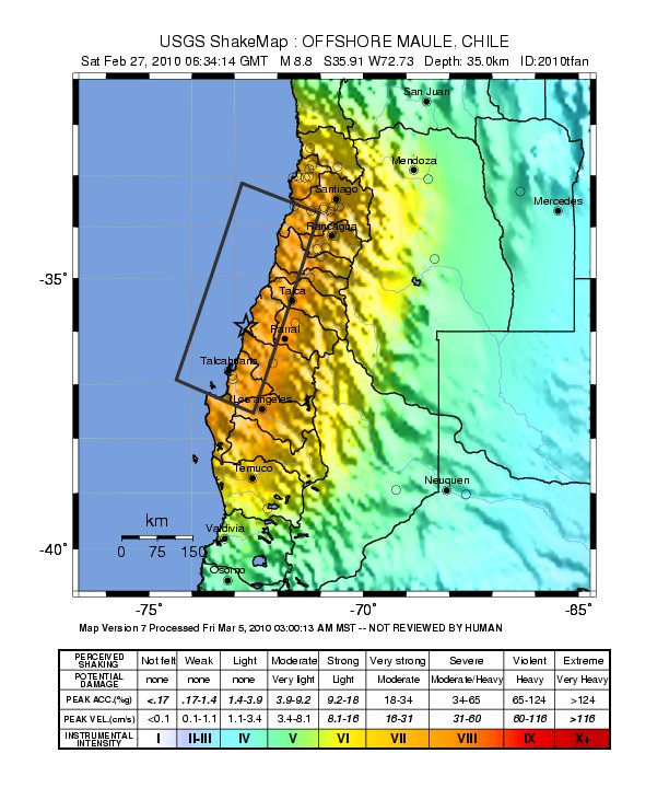
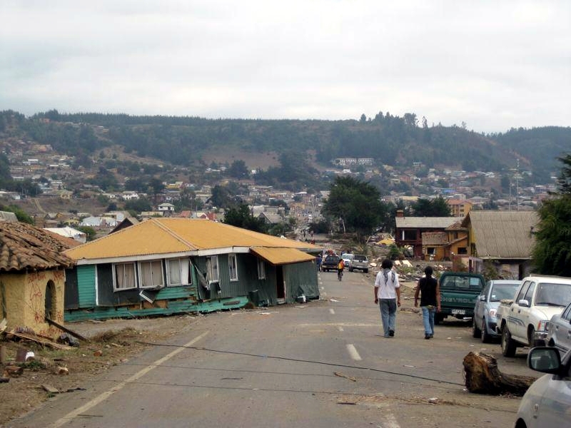

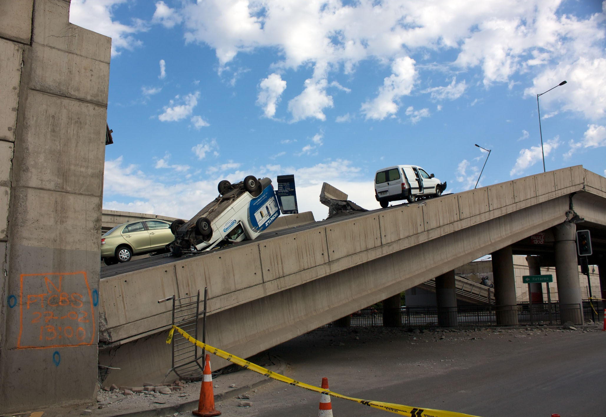
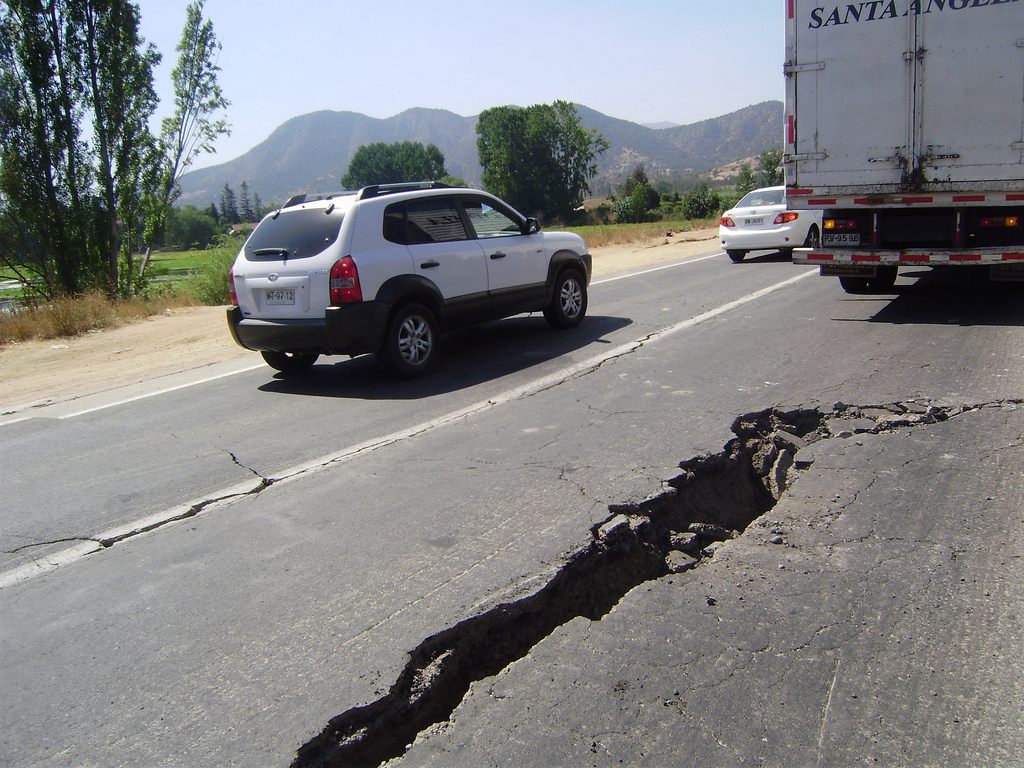


Wikimedia Foundation. 2010.