Chelmer railway station

Chelmer railway station
Chelmer
Chelmer stn.jpeg
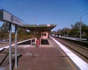
Station statistics
Address 140 Honour Avenue, Chelmer
Coordinates 27°30′43″S 152°58′22″E / 27.5120°S 152.9728°E / -27.5120; 152.9728Coordinates: 27°30′43″S 152°58′22″E / 27.5120°S 152.9728°E / -27.5120; 152.9728
Lines
  Ipswich Line
  Springfield Line
Platforms 4 total (2 island platforms)
Other information
Owned by Queensland Rail
Fare zone 2 (TransLink)
Services
Preceding station   Queensland Rail   Following station
Indooroopilly
toward Bowen Hills
Ipswich Line
Graceville
toward Rosewood
Indooroopilly
toward Bowen Hills
Springfield Line
Graceville
toward Richlands

Chelmer Station is a railway station in Chelmer, a suburb of Brisbane, Australia, on the Ipswich and Rosewood and Springfield lines.

Contents

History

Chelmer Station opened north of it's current location in 1876 as Oxley's Point. In 1888, the station was renamed Riverton. A siding was built at the current station location in 1881, which was later converted into Chelmer Station in 1889. Riverton Station was closed that same year.[1]

See also

References

External links


Wikimedia Foundation. 2010.

Игры ⚽ Поможем решить контрольную работу

Look at other dictionaries:

  • Chelmer railway station, Brisbane — Citytrain Station station name=Chelmer region=Brisbane South servicearea1=Ipswich IB1=Indooroopilly OB1=Graceville street=Honour Avenue and Halsbury Street suburb=Chelmer zone=2 distance=8.46 platforms=4 platform arch=2 island access=underpass… …   Wikipedia

  • Oxley railway station — Oxley Station statistics Address Ardoyne Road, Oxley Coordinates …   Wikipedia

  • Corinda railway station — Corinda Station statistics Address Cnr Watt Street Ruthven Street, Corinda Coordinates …   Wikipedia

  • Darra railway station — Darra Station statistics Address Darra Station Road, Darra Coordinates …   Wikipedia

  • Dinmore railway station — Dinmore Station statistics Address River Road and Mason Street, Dinmore Coordinates …   Wikipedia

  • Chelmer, Queensland — Chelmer Brisbane, Queensland Population: 2,715 (2004)[1] Postcode: 4068 …   Wikipedia

  • Milton railway station, Brisbane — Milton Station statistics Address Milton Road, Milton Coordinates …   Wikipedia

  • Indooroopilly railway station, Brisbane — Citytrain Station station name=Indooroopilly region=Brisbane West servicearea1=Ipswich IB1=Taringa OB1=Chelmer street=Coonan Street suburb=Indooroopilly zone=2 distance=7.38 platforms=4 platform arch=2 island access=underpass trainconnect=no… …   Wikipedia

  • Graceville railway station, Brisbane — Citytrain Station station name=Graceville region=Brisbane South servicearea1=Ipswich IB1=Chelmer OB1=Sherwood street=Honour Avenue and Appel Street suburb=Graceville zone=2/3 distance=9.47 platforms=4 platform arch=2 island access=underpass… …   Wikipedia

  • List of South East Queensland railway stations — This is a list of the suburban and interurban railway stations of south east Queensland, Australia focused around Brisbane, the capital city of Queensland.These services are operated by QR Citytrain under TransLink.For detailed travel information …   Wikipedia

Share the article and excerpts

Direct link
Do a right-click on the link above
and select “Copy Link”