- Chattahoochee RiverWalk
-
The Chattahoochee RiverWalk is a 22 mile walking and biking area along the Chattahoochee River in Columbus, Georgia, United States. The entire trail is paved with either asphalt, concrete, or brick. Due to the RiverWalk bike path, Columbus was recently identified by the League of American Bicyclists as one of the forty most Bicycle Friendly Communities in the United States.[1]
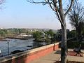
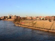 The Chattahoochee Riverwalk from the Dillingham Street Bridge.
Contents
History
In 1989 construction began on the first phase RiverWalk, and it was not until October 12, 1992 (Columbus Day) when the project was officially opened for use. A statue of Christopher Columbus can be found on the RiverWalk near the Dillingham Street bridge. The second phase of the RiverWalk extended it from the Columbus Convention and Trade Center in Downtown to Oxbow Meadows in South Columbus. Before expanding the North end of the RiverWalk, the city extended the path to the Infantry Center at Fort Benning. The stretch from the TSYS building to the Bibb Mill was constructed in the third phase, which was followed by the construction of the fourth phase which extended the RiverWalk from the Bibb Mill to the Lake Oliver Dam. Construction began in 2009 to connect the RiverWalk from the 14th Street bridge to the Eagle & Phenix Dam. This section opened in early 2011.
The Path
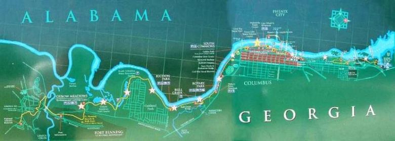
The RiverWalk begins in North Columbus at Lake Oliver and extends southward twenty two miles to Fort Benning. Currently, it is divided into three areas. The first area runs from the Lake Oliver Dam to the North Highlands Dam. The second section begins south of the North Highlands Dam, which can be accessed from First Avenue, and ends at the Fourteenth Street Pedestrian Bridge and TSYS. Construction is currently underway to connect the second and third sections of the RiverWalk. At this time the third section runs from the Eagle & Phenix Dam to Fort Benning. There are a total of eleven designated access points. Recent construction and expansion ensures a more continuous way for people who want to go to Fort Benning from Lake Oliver Marina. Now that this extension is complete, there is only two remaining sections of the RiverWalk to be completed: the City Mills site and the Bibb Mill site. The 14th Street bridge is also slated for major renovations to be completed in 2011.[2]
The Chattahoochee RiverWalk also connects to the Phenix City RiverWalk at the 14th Street Bridge. The Phenix City RiverWalk currently extends from the Dillingham Street bridge to the 14th Street bridge, but within the year it will extend all the way up to the City Mills Dam on the Alabama side of the Chattahooche.[3]
Sights
Sites along the RiverWalk include the site of the Battle of Columbus, Georgia, Total System Services, former Bibb Manufacturing Company, the National Infantry Museum, the National Civil War Naval Museum at Port Columbus, Golden Park baseball stadium, Oxbow Meadows Learning Center,[4] and Oxbow Creek Golf Course.
While traveling south of the Columbus Civic Center on the RiverWalk, patrons should advise caution for alligators. There are signs warning that the area is an Alligator Habitat.[5]
Map
Gallery
-

The Riverwalk begins just off of River Road at the Lake Oliver Dam. This access point is hidden approximately one quarter of a mile from River Rd.
-

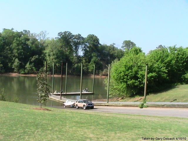
A boat being unloaded at Rotary Park
-

After being in a drought for a few years in the past, the Chattahoochee was filled with much needed rain in March of 2009. The river exceeded its banks, flooding the Riverwalk. This picture was taken after the water levels dropped.
-

This is a picture of Columbus in the 19th century. The bridge to the left was the Upper Bridge (now the 14th Street Pedestrian Bridge) and the bridge to the right was the Lower Bridge (now the Dillingham Street Bridge.
-

March 2009 flood waters had receded some in this picture, but the high water level is evident from the water seen on the Riverwalk.
-

A look at the 14th Street Bridge from Phenix City Riverwalk. This bridge now stands were the Upper Bridge once stood.
-

This picture shows a section of the Riverwalk just south of the North Highlands Dam, which can be seen in the background.
-

Another view of the Riverwalk from the North Highlands Dam area.
-
A view of the Eagle and Phenix Dam from Bay Street in front of Synovous.
-

A southward view of the Riverwalk. Picture taken on Bay Street at Synovous.
-

The newest edition of the Chattahoochee Riverwalk.
References
- ^ League of American Bicyclists
- ^ Renovations to the 14th Street Bridge
- ^ Phenix City RiverWalk on schedule
- ^ Oxbow Meadows Learning Center's Website
- ^ News Video explaining the "Alligator Habitat" signs on the Chattahoochee Riverwalk.
External links
- Chattahoochee Riverwalk Information
- Chattahoochee Riverwalk Bicycle Tours
- Journal of a Daily Chattahoochee Riverwalker
- New Construction on Riverwalk
- Whitewater Rafting Announcement
- New construction on Phenix City side of Chattahoochee Riverwalk
- Expected Impact of Whitewater Rafting
Columbus, Georgia Subject areas Airport · Greater area · Hospitals · Mayor · Media · Neighborhoods · Parks · Public school system · Public transitAttractions Chattahoochee RiverWalk · Columbus Civic Center · Golden Park · National Civil War Naval Museum · National Infantry Museum · RiverCenter for the Performing Arts · Springer Opera HouseShopping Columbus Park Crossing · Peachtree Mall · The Landings · The Shoppes at Bradley ParkNotable colleges & universities Surrounding cities
(with a pop. over 1K)Categories:- Geography of Columbus, Georgia
- Visitor attractions in Columbus, Georgia
- Protected areas of Muscogee County, Georgia
-


Wikimedia Foundation. 2010.