- Chatsworth, Los Angeles
-
Chatsworth — Neighborhood of Los Angeles — Location within Los Angeles/San Fernando Valley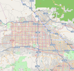
 Chatsworth
Coordinates: 34°15′26″N 118°36′04″W / 34.25722°N 118.60111°W Country United States State California County Los Angeles City Los Angeles Elevation 978 ft (298 m) Population (2000)[1] – Total 41,255 Time zone PST (UTC-8) – Summer (DST) PDT (UTC-7) ZIP code 91311 Area code(s) 818 Chatsworth is a district of Los Angeles, California, United States; in the northwestern San Fernando Valley. The district is bordered by the Santa Susana Mountains and unincorporated Los Angeles County lands to the north, Porter Ranch to the northeast, Northridge to the east, West Hills, Canoga Park, and Winnetka to the south, and the Simi Hills, Ventura County, Simi Valley to the west. The nearby Chatsworth Peak in eastern Simi Hills overlooks the district.
Contents
History
Native Americans
 The center of Chatsworth, 1911, on what is now Topanga Canyon Boulevard.
Chatsworth was originally inhabited by the Tongva-Fernandeño, Chumash-Venturaño, and Tataviam-Fernandeño Native American tribes. Native American civilizations had inhabited the Valley for an estimated 8,000 years. Stoney Point is the site of the Tongva Native American settlement of Asha'awanga or Momonga, that was also a trading place with the neighboring Tataviam and Chumash people.[2][3][4] The nearby Burro Flats Painted Cave remains a legacy of the Chumash culture's rock art and solstice ceremony spirituality.[5]
Spain and Mexico
The first European explorers came into the Chatsworth area on August 5, 1769, led by the Spanish military leader Gaspar de Portolà. With its establishment in 1797 and subsequent Spanish Land Grant by the King of Spain, Mission San Fernando (Mission San Fernando Rey de España) gained dominion over the San Fernando Valley's lands, including future Chatsworth.
The Native American trail that had existed from the Tongva-Tatavium village called rancheria Santa Susana (Chatsworth) to another village, replaced by Mission San Fernando, became the route for missionaries and other Spanish travel up and down California. It was part of the El Camino del Santa Susana y Simi trail that connected the Valley's Mission, Los Angeles pueblo (town), and the southern missions with the Mission San Buenaventura, the Presidio of Monterey, and the northward missions. The trail crossed over the Santa Susana Pass to the in Simi Valley, through present day city park Chatsworth Park South and the Santa Susana Pass State Historic Park. In 1795, the Spanish land grant had been issued for Rancho Simi, reconfirmed in 1842 by the Mexican governor.[6][7][8] Its lands included part of current Chatsworth, westward from Andora Avenue.
In 1821, after the successful Mexican War of Independence from Spain, the Mission San Fernando became part of Alta California, Mexico. In 1834, the Mexican government began redistributing the mission lands. In 1846, the Mexican land grant for Rancho Ex-Mission San Fernando was issued by Governor Pío Pico. It was bounded on the north by Rancho San Francisco and the Santa Susana Mountains, on the west by the Simi Hills, on the east by Rancho Tujunga, and on the south by the Montañas de Portesuelo (Santa Monica Mountains). The Rancho Ex-Mission San Fernando received a Federal land patent to retain ownership by the United States Public Land Commission in 1873, and was the single largest land grant in California.[9]
United States
In 1869, the grantee's son, Eulogio F. de Celis, returned from Spain to Los Angeles.[10] In 1874, the family sold their northern half of Rancho Ex-Mission San Fernando to northern Californians, California State Senator Charles Maclay and his partners George K. Porter, a San Francisco shoe manufacturer, and his brother Benjamin F. Porter. The Porters’ land was west of present day Sepulveda Boulevard including most of Chatsworth, and the Maclay land was east of Sepulveda Boulevard.[11] Roscoe Boulevard was the border on the south, with a syndicate led by Issac Lankershim acquiring the southern half of the Valley.

The Old Santa Susana Stage Road or Santa Susana Wagon Road is a route taken by early travellers between the San Fernando Valley and Simi Valley through Chatsworth and over the Santa Susana Pass. The main route climbs through what is now Santa Susana Pass State Historic Park, with a branch in Chatsworth Park South. It was an important artery linking the Los Angeles Basin and inland Ventura County, and was part of the main route for travel by stagecoach between Los Angeles and San Francisco from 1861 until the opening of rail traffic between the cities in 1876. The Old Santa Susana Stage Road is listed on the National Register of Historic Places. Part of the stage road is also a Historic-Cultural Monument of Ventura County and of the city of Los Angeles under the name 'Old Stagecoach Trail'.
The Santa Susana Pass Road continued in use as an alternative to the route along El Camino Viejo from 1861 to 1875, replacing the older road as the main route between Los Angeles and San Francisco. In 1876, the Southern Pacific Railroad opened a tunnel through the Newhall Pass, enabling rail connections from Los Angeles north to San Francisco, and rail travel soon replaced travel by stagecoach between Los Angeles and San Francisco. From this time, the stagecoach traffic to Santa Barbara once again used the coast route, and the Santa Susana Pass road was relegated to local traffic.[12]
A new wagon route bypassing the deteriorating Devil's Slide was opened in 1895. Initially called El Camino Nuevo (the New Road), it was later named the Chatsworth Grade Road, which continued in use until Santa Susana Pass Road (now Old Santa Susana Pass Road) was built in 1917.[12] In the 1920s Movie Ranches began in the hills of Chatsworth, for both the dramatic scenery and being within the Studio zone.
The present town was first called 'Chatsworth Park' and developed in 1888. It was named after Chatsworth House, the family seat of the Duke of Devonshire in Derbyshire, United Kingdom. The Devonshire name was also used for the naming the major east-west boulevard in Chatsworth.
Demographics
As of the 2000 census, and according to the Los Angeles Almanac, there were 41,255 people and 15,668 households residing in Chatsworth. The racial makeup of the neighborhood was 70.99% White, 14.33% Asian, 0.14% Pacific Islander, 3.51% African American, 0.51% Native American, 6.11% from other races, and 4.41% from two or more races. 16.31% of the population were Hispanic of any race.
Median household income in 2000 was $63,817.
In 2009, the Los Angeles Times "Mapping L.A." project supplied these Chatsworth neighborhood statistics: population: 33,829; median household income: $84,549.[13]
Government and infrastructure
The Chatsworth Branch Library, operated by the Los Angeles Public Library, is located at 21052 Devonshire Street.[14]
The Chatsworth Post Office, of the United States Postal Service, is located at 21606 Devonshire Street.[15] (The Chatsworth Post Office was one of the locations of an anthrax threat shortly after the 9/11 terrorist attacks.)[citation needed]
The U.S. Census Bureau operates the Los Angeles Regional Census Center in Chatsworth.[16][17]
Transportation
The Chatsworth Transportation Center and train station is a major transportation hub for the town and West Valley. It is served by 20 daily trains on the Metrolink Ventura County Line from Ventura to Union Station in Downtown Los Angeles, and by the Amtrak California Pacific Surfliner, with 10 trains up and down the state daily.[18] The Coast Line for freight transport by Union Pacific Railroad also uses the tracks, and was involved in the 2008 Chatsworth train collision.
Construction is underway to extend the Orange Line of the Los Angeles Metro system to Chatsworth Station, with a dedicated right-of-way across the Valley to North Hollywood Station of the Red Line subway.[19][20][21]
The Chatsworth Transportation Center also offers connections to several Los Angeles Metro, Simi Valley, and Santa Clarita bus routes. It is located at 10046 Old Depot Plaza Road, between Devonshire and Lassen streets.[22]
Education
Chatsworth residents are zoned to the Los Angeles Unified School District. Chatsworth High School, Lawrence Middle School, Germain Street Elementary, Superior Street Elementary and Chatsworth Park Elementary School are all located in Chatsworth.
The area has several private schools, including Sierra Canyon, Chatsworth Hills Academy, Chaminade College Preparatory Middle School, and St. John Eudes Elementary and Middle School.
There is also one charter school, Chime Charter Middle School previously known as Santa Susana School. The school is located just down the street from Chatsworth Park Elementary School.
Charter school
Our Community School - Kindergarten through Seventh Grade (Mayall/Jumilla) Ingenium Charter School - Kindergarten through Sixth Grade
Parks and recreation
Chatsworth is distinguished by having more parks and parkland acreage than most communities in Los Angeles. The City of Los Angeles Parks and Recreation Department, California Department of Parks and Recreation, and the Santa Monica Mountains Conservancy operate the various natural open space preserve parks and neighborhood recreation parks.
Open-space parks
- Chatsworth Park North includes more than 20 acres (81,000 m2) of the scenic Simi Hills and is operated by the Los Angeles Parks Department.[23][24] Chatsworth North Park has a baseball diamond, American football field, and outdoor basketball courts - all lighted; volleyball courts, a children's play area, hiking trails, a jogging path, and picnic tables with barbecue pits.[25] The Park now has fencing that blocks visitors from climbing the large boulder outcrops, however Stoney Point Park and Chatsworth Park South are nearby for bouldering and rockclimbing.
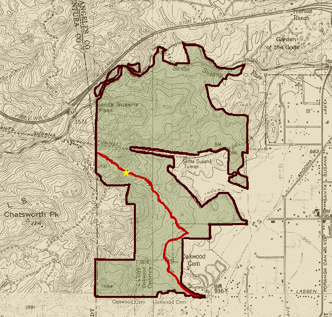
 West chatsworth and the Santa Susana Pass State Historic Park; with the Old Santa Susana Stage Road in red.
- Chatsworth Park South includes more than 100 acres (0.40 km2) of the rocky landmark Simi Hills.[26] Chatsworth Park South is adjacent to the Santa Susana Pass State Historic Park, a 174-acre (0.70 km2) National Register of Historic Places property consisting of historic features and deposits, prehistoric village site remnants, and portions of the Old Santa Susana Stage Road which was the main route for mail and travelers between Los Angeles and San Francisco from 1861 until the opening of rail connections between the two cities in 1876. The stage route was also declared Los Angeles City Historical Cultural Monument #92 (designated 01/05/1972) and Ventura County Historical Landmark #104 (designated 10/21/1986).[27] The park has miles of horseback, jogging, and hiking trails, picnic tables and barbecue pits, and bouldering outcrops.[28]
- Chatsworth Recreation Center facilities are located within the lower area of Chatsworth Park South; with lighted indoor basketball courts, lighted outdoor basketball courts, a children's play area, an indoor gymnasium, a stage, and lighted tennis courts.[29]
- The Minnie Hill Palmer House and Museum, one of the West Valley's historic original homestead houses, is in Chatsworth Park South for visits and the Chatsworth Historical Society archives.
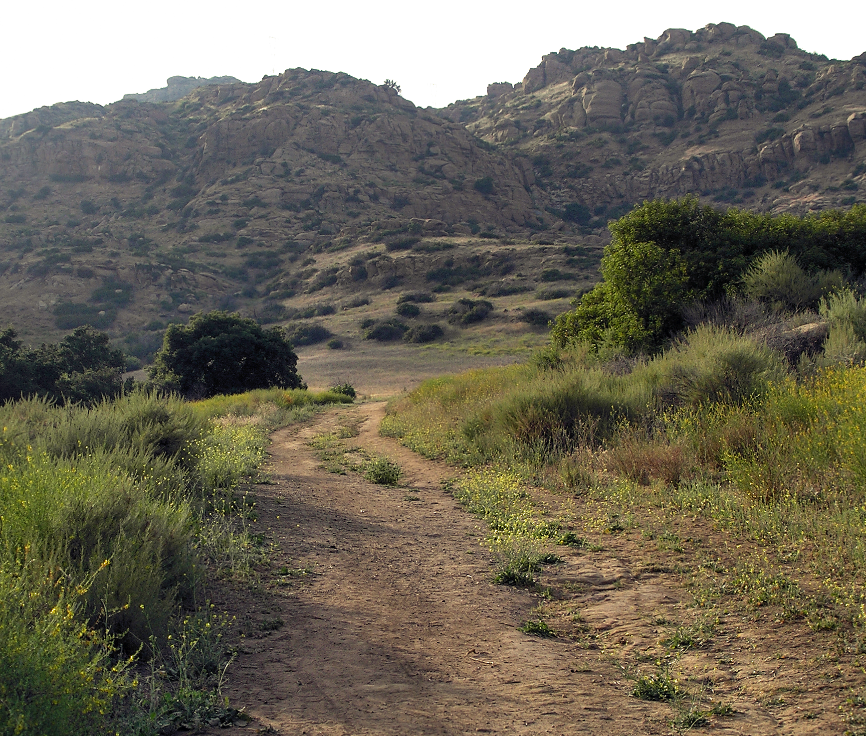
- Santa Susana Pass State Historic Park (SSPSHP) is a large natural area adjacent to and above town's western side.[30] The Santa Susana Pass State Historic Park protects and offers a historical site of the late 19th century, when Chatsworth was on a main thoroughfare for the figures of the American West. Joaquin Murrieta and his bandits hid out in the rocky crevices around Stony Point. The Old Stagecoach Trail above Chatsworth to the west, is now a popular hiking trail in the Simi Hills. It goes through Santa Susana Pass State Historic Park and Chatsworth Park South, and by Chatsworth Oaks Park. The State Park is open to the public with several parking and trailhead areas and many hiking and view opportunities.[31]
- Chatsworth Oaks Park is an approximately 3-acre (1.2 ha) natural open space park. It has barbecue pits, a children's play area, and picnic tables near the parking area. Beyond visitors may ride bicycles and hike in the park, which has no established trails but links to nearby Santa Susana Pass State Historic Park. The park overlooks the Chatsworth Nature Preserve, with birdwatching opportunities.[32]
 Stoney Point Park in Chatsworth.
- Stoney Point Park, at Stoney Point is a natural rock outcropping, geographic promentory landmark, and legendary bouldering and rock climbing location on 76-acre (31 ha). The boulders at Stoney Point Park merge and form alcoves, caves, and dens. The park also has bridle paths, hiking trails, and connections to adjacent parks to the north.[33] Stoney Point is the site of the Tongva settlement named Asha'awanga or Momonga.[2]
- Chatsworth Trails Park is in the Santa Susana Mountains foothills just north of the 118 Freeway with parking at 11200 Mayan Drive. Chatsworth Trails Park has miles of horseback, hiking, and mountain biking trails, and is also a hub connecting to the huge Michael D. Antonovich Regional Park at Joughin Ranch, the Indian Springs Open Space Park, and Rocky Peak Park at Rocky Peak.[34][35] The Rim of the Valley Trail passes through here, with trailhead access.[36]
- Sage Ranch Park overlooks Chatsworth from its 2,000-foot (610 m) high ridges in the Simi Hills near the Santa Susana Field Laboratory. It is a new open space park at the end of Woolsey Canyon Road. Sage Ranch Park has campsites, walking and hiking trails, and panoramic views of the San Fernando and Simi Valleys.[37][38]
Neighborhood parks
- Mason Park[39] It offers barbecue pits, a lighted baseball diamond, an unlighted baseball diamond, a children's play area, and picnic tables.[39]
- Mason Recreation Center[40] It has an indoor gymnasium that may also be used as an auditorium; the capacity is 400 has a kitchen, a multi-purpose field, and a stage.
- Mason Child Care Center [41] It is licensed to have up to 30 children of ages 3 and 4 and up to 60 school age children in educational and recreational activities at the center.
Modern terrain
The topography of modern Chatsworth is varied, with many industrial areas, sleepy home communities, large apartment and condominium complexes, parks, ranches, horse stables, horse trails, and farms, a few shopping centers, restaurants, and a train station. Congressman Buck McKeon (25th District) notes on his web page, "Chatsworth still has a lot of horse zoned properties and it is not unusual to see horses tied to the hitching post out back of the Los Toros Mexican Restaurant or the Cowboy Palace Saloon."[citation needed]
Chatsworth's residential homes are mostly single-story classic American ranch houses. The district's boundaries are not visible, marked only by signs on the streets, as a profusion of stores, apartments, and automobile traffic dominate.
Chatsworth Reservoir
A distinctive feature in Chatsworth is the Chatsworth Reservoir, mostly drained since the 1971 San Fernando earthquake. The property belongs to the Los Angeles Department of Water and Power. Chatsworth Oaks Park and the Chatsworth Nature Preserve are located here giving views of migrating birds and other animals, and their sounds such as the coyotes calling in the evening. The views of the rocky and dramatic Simi Hills surround the open space.[42]
Business
Chatsworth is the home of the National Notary Association and the headquarters for three major credit unions: Premier America (Formerly Litton Federal Credit Union), Matadors Community Credit Union and Telesis Community Credit Union.
The Santa Susana Field Laboratory (SSFL), once busy with Rocketdyne testing rocket engines and Atomics International doing nuclear research, is quiet and high in the Simi Hills west of Chatsworth.[43] It has been closed and will be undergoing an extensive environmental cleanup, and become an open-space park.[44] The park will permanently add to Chatsworth's scenic backdrop, greenway, and hiking opportunities.[45]
Some current businesses based in Chatsworth are: 3M Corporation, Girl Scouts,[citation needed] Capstone Turbine, Hydraulics International, and with Lamps Plus having production and distribution facilities here.
Entertainment industry
Chatsworth remained mostly rural until the 1960s, and as a result, its movie ranches became the site for many western films and rural-themed television shows. Noteworthy ones above Chatsworth were the Iverson Movie Ranch, Spahn Movie Ranch, and Corriganville Movie Ranch. The setting fit the popular conception of the American West; boulders larger than houses were strewn against a backdrop of mountains. Tumbleweeds were and still are a common sight. California Live Oaks (Quercus agrifolia) and white-barked California Sycamores (Platanus racemosa), trees native to Chatsworth, along with Australian eucalyptus trees (Eucalyptus globulus), and orange trees in groves all lent to the rural feel for natural film scenery.
Between 1912 and 1960, Hopalong Cassidy, Gene Autry, Roy Rogers and hundreds of other cowboys made movies at Iverson Movie Ranch. A five-hundred acre portion of the ranch was transformed into terraced Chinese farmland for filming the MGM classic The Good Earth (1937), originally a popular novel by Pearl S. Buck.[46] Disney's Zorro was filmed on the Chatsworth Spahn Movie Ranch, as were the opening credits of The Lone Ranger. Also filmed partly in Chatsworth by Roy Rogers Productions was the western series Brave Eagle starring Keith Larsen as a young Cheyenne chief, which ran on CBS in the 1955–1956 season.
Currently, in the film industry, Chatsworth continues to house numerous mainstream production offices, including that of the television show 24. Ghost of Zorro was filmed here in 1949. The Iraq scenes for the TV series Over There were filmed in Chatsworth. The Bad News Bears (1976) was filmed in Mason Park. The town also houses many adult production and distribution studios, including Anabolic Video, Black Market, Combat Zone, KBeech, Red Light District Video, Third World Media, and Wicked Pictures. Sex industry trade magazine AVN is also headquartered in Chatsworth.
Past and present residents
See also: Von Sternberg house by NeutraIn 1932 the film director Josef von Sternberg commissioned architect Richard Neutra to design a residence in the avant-garde American modernism architectural style, known as the Von Sternberg house. It was located inside a silver walled compound on his estate's acreage of walnut groves in Chatsworth. The author and philosopher Ayn Rand acquired the property, with the modernism evocative of her novel 'The Fountainhead,' and resided there. The landmark residence was demolished in 1972 for construction of the Teledyne complex.
Chatsworth's proximity to Hollywood studios meant that a number of actors and musicians call or have called the district home. Lucille Ball and Desi Arnaz established their first home on a 5-acre (20,000 m2) parcel in Chatsworth, which they called "Desilu," the same name as their studio. Roy Rogers and Dale Evans had a horse ranch in Chatsworth for several decades, as did Errol Flynn, and cowboy film star Montie Montana. In television, Mr. Ed, the 1960s equine star, was born in a red barn on "Harvester Farms" located near Topanga Canyon Boulevard and Devonshire Avenue. The site became the home of the Palomino Horse Association of America for a short period of time.
Oakwood Memorial Park Cemetery in Chatsworth is the final resting place of a number of Hollywood stars, including Fred Astaire, Ginger Rogers, Oscar winner Gloria Grahame, and silent film actor and director Grace Cunard. Some of the stars were in films shot on the Spahn and Iverson Movie Ranches above Chatsworth.
Recent examples include:
- R&B singer Brian McKnight
- Professional Skateboarder Paul Rodriguez Jr.
- Shock rock musician Marilyn Manson (between 2004 and 2006)[47]
- Author Gerina Dunwich
- Former child actress Noreen Corcoran
- Screenwriter and film director Bob Forward
- Helicopter pilot/television news reporter Desiree Horton
- Kansas City Royals 3rd baseman and 2nd overall pick in 2007 MLB Draft Mike Moustakas
- Rapper/Dancer - Kevin Federline
- Hip-hop/rapper - Xzibit
Actors Kevin Spacey, Mare Winningham, Adam Rich, Val Kilmer, and Kirk Cameron graduated from Chatsworth High School. Spacey thanked the drama department of his alma mater when he won his first Oscar.[citation needed]
See also
- Lassen Street Olive Trees (Chatsworth, California)
- Old Santa Susana Stage Road
- Burro Flats Painted Cave
- History of the San Fernando Valley to 1915
- List of Los Angeles Historic-Cultural Monuments in the San Fernando Valley
References
- ^ "Los Angeles Almanac: City of Los Angeles Population by Community & Race 2000 Census". http://www.laalmanac.com/population/po24la.htm. Retrieved April 5, 2010.
- ^ a b http://keepersofindigenousways.org/sitebuildercontent/sitebuilderpictures/NewTongvaMap6.2.08.jpg keepersofindigenousways.org "NewTongvaMap" accessed 6/18/2010
- ^ "Prehistoric milling site found in California." USA Today. March 3, 2006. Updated March 4, 2006. Retrieved on March 22, 2010.
- ^ Mercury News article
- ^ Kenneth Lubas (1971-01-31). "Indians Trying To Safeguard Cave Paintings of Ancestors: Mission Tribe Will Ask Rocketdyne To Enclose Historic Works in Glass for Protection Against Any Vandalism". Los Angeles Times.
- ^ Report of the Surveyor General 1844 - 1886
- ^ United States. District Court (California : Southern District) Land Case 103 SD
- ^ Diseño del Rancho Simi
- ^ C. A. Ensign, 1903, Notes of Litigation on the Title of a Mexican Land Grant, The Michigan Engineer, Volumes 22-25, pp1124-147, Michigan Engineering Society
- ^ Romantic Day, Pathetic End: Sad Burial of Once Wealthy Scion of Spain, Los Angeles Times, May 26, 1903, Eulogio F. de Celis
- ^ K. Roderick, 2001, The San Fernando Valley: America’s Suburb, Los Angeles Times, Los Angeles, California, ISBN 978-1883792558
- ^ a b Bevill, Arthur D. (2007). Santa Susana Pass State Historic Park Cultural Resource Survey Historic Overview. http://www.parks.ca.gov/pages/980/files/sspshp%20historic%20resources.pdf.
- ^ "Chatsworth" entry on the Los Angeles Times "Mapping L.A." website
- ^ "Chatsworth Branch Library." Los Angeles Public Library. Retrieved on December 6, 2008.
- ^ "Post Office Location - CHATSWORTH." United States Postal Service. Retrieved on December 6, 2008.
- ^ "The Los Angeles Region." U.S. Census Bureau. Retrieved on January 17, 2010.
- ^ "Boundary Map." Chatsworth Neighborhood Council. Retrieved on January 17, 2010.
- ^ http://metrolinktrains.com/ (accessed: 6/20/2010)
- ^ http://www.metro.net/projects/orangeline/ (accessed: 6/20/2010)
- ^ http://www.metro.net/around/rail/orange-line/ Official Orange Line website: map & times. (accessed: 6/20/2010)
- ^ http://www.metro.net/around/rail/red-line/ (accessed: 6/20/2010)
- ^ http://www.metrolinktrains.com/documents/Connecting_Transit/Chatsworth.pdf Connecting_Transit/Chatsworth (accessed: 6/20/2010)
- ^ "Chatsworth Park North". LAMountains.com. http://www.lamountains.com/parks.asp?parkid=70. Retrieved 2010-02-05.
- ^ http://www.laparks.org/dos/parks/facility/chatsworthPkNorth.htm
- ^ "Chatsworth North Park." City of Los Angeles. Retrieved on March 22, 2010.
- ^ "Chatsworth Park South". LAMountains.com. http://www.lamountains.com/parks.asp?parkid=71. Retrieved 2010-02-05.
- ^ http://www.parks.ca.gov/default.asp?page_id=611
- ^ "Chatsworth Park South." City of Los Angeles. Retrieved on March 22, 2010.
- ^ "Chatsworth Recreation Center." City of Los Angeles. Retrieved on March 22, 2010.
- ^ State Park=SSPSHP
- ^ http://www.lamountains.com/parks.asp?parkid=123 l.a.Parks: SSPSHP Hikes + Trails Map
- ^ "Chatsworth Oaks Park." City of Los Angeles. Retrieved on March 22, 2010.
- ^ "Stoney Point Park." City of Los Angeles. Retrieved on March 22, 2010.
- ^ http://www.wikimapia.org/#lat=34.2849142&lon=-118.6019611&z=15&l=0&m=b Chatsworth Trails Park Map; accessed: 6/20/2010
- ^ http://www.lamountains.com/parks.asp?parkid=36 Michael D. Antonovich Regional Park at Joughin Ranch; accessed 6/20/2010
- ^ http://www.nps.gov/pwro/rimofthevalley/ Rim of the Valley Trail; accessed 6/20/2010
- ^ http://www.fechser.com/Sage%20Ranch.htm Sage Ranch Park photos. accessed 6/18/2010
- ^ www.lamountains.com/parks.asp?parkid=53 Official Sage Ranch Park website. accessed 6/18/2010
- ^ a b "Mason Park." City of Los Angeles. Retrieved on March 22, 2010.
- ^ "Mason Recreation Center." City of Los Angeles. Retrieved on March 22, 2010.
- ^ "Mason Child Care Center." City of Los Angeles. Retrieved on March 22, 2010.
- ^ Chatsworth Nature Preserve
- ^ ACME-SSFL info site
- ^ http://www.dtsc-ssfl.com/ State DTSC-SSFL info site
- ^ SSFL forum
- ^ Hay, Peter (1991), MGM: When the Lion Roars, Atlanta: Turner Publishing, Inc., p. 140, ISBN 1-878685-04-X
- ^ http://www.marilynmanson.com/media/print/spin_05_07/
External links
- Chatsworth Neighborhood Council
- Chatsworth Historical Society
- official Santa Susana City Park website
- California State Parks Dept. - official Santa Susana Pass State Historic Park website
- LAMountains.com - Santa Susana Pass Historic Park hiking website
- official Los Angeles City Parks: Chatsworth Park South website
- (Chatsworth Equine Cultural Heritage Organization) Chatsworth Historical Trivia
Coordinates: 34°15′26″N 118°36′01″W / 34.25722°N 118.60028°W
Los Angeles city areas within the San Fernando and Crescenta Valleys Districts and
neighborhoodsArleta · Canoga Park · Chatsworth · Encino · Granada Hills · Lake View Terrace · Lake Balboa · Mission Hills · NoHo Arts District · North Hills · North Hollywood · Northridge · Pacoima · Panorama City · Porter Ranch · Reseda · Shadow Hills · Sherman Oaks · Studio City · Sun Valley · Sunland · Sylmar · Tarzana · Toluca Lake · Tujunga · Valley Village · Van Nuys · Ventura Business District · Warner Center · West Hills · Winnetka · Woodland Hills
Points of
interestSee also Downtown · Eastside/Northeast · Harbor Area · Greater Hollywood · Westlake & Silver Lake/Los Feliz · San Fernando and Crescenta Valleys · South Los Angeles · Westside · WilshireCity of Los Angeles Topics History • Transportation • Culture • Landmarks • Historic sites • Skyscrapers • Demographics • Crime • Sports • Media • Music • Notable people • Lists
Government Flag • Mayors • City Council • Other elected officials • Airport • DWP • Fire Department • Police • Public schools • Libraries • Port • TransportationRegions Downtown • Eastside/Northeast • Harbor Area • Greater Hollywood • Westlake & Silver Lake/Los Feliz • San Fernando and Crescenta Valleys • South Los Angeles • Westside • WilshireCategories:- Neighborhoods in Los Angeles, California
- Communities in the San Fernando Valley
- Populated places established in 1888
- San Fernando Valley


Wikimedia Foundation. 2010.