- Chad Basin National Park
-
Chad Basin National Park IUCN Category II (National Park)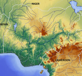

Location Borno State,  Nigeria
Coordinates 11°45′0″N 14°15′0″E / 11.75°N 14.25°ECoordinates: 11°45′0″N 14°15′0″E / 11.75°N 14.25°E Area 2258 sq. km The Chad Basin National Park is a national park in northeastern Nigeria, with a total area of about 2,258 km². The park is fragmented, with three sectors. The Chingurmi-Duguma sector is in Borno State, in a Sudanian Savanna ecological zone. The Bade-Nguru Wetlands and Bulatura sectors are in Yobe State in the Sahel ecological zone.[1]
Contents
Status
The park combines the former Chingurmi-Dugoma Game Reserve, Gorgoram and Zurgun Baneri Forest Reserves, and Bulature Oasis. As of 1999 it had not been surveyed, so the boundaries are not well-established. The park is used by many farmers, grazers and fishermen.[2] Despite significant investment in lodgings for tourists, the park sectors only attract a few hundred visitors each year due to the lack of spectacular wildlife.[3] By 2008, staff at the park office in Maiduguri knew little about the park, the lodgings had been abandoned, and tourists visiting the park sectors had to take off-road vehicles and be prepared to camp out.[4]
Chingurmi-Duguma sector
The Chingurmi-Duguma sector is in the Bama Local Government Area of Borno State, adjoining the Waza National Park in the Republic of Cameroon, around coordinates 11°45′0″N 14°15′0″E / 11.75°N 14.25°E. It has an area of 1,228 km2, with a stratified topology. The northern part is within the Sahel zone while southern sector has a typical Sudan–Guinea Savanna ecology, and includes Acacia-Balanites woodlands separated by dense stands of Elephant grass and Sorghum.[1]
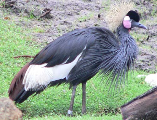
Waters from the Dorma river flood much of the sector in the rainy season, creating flood-plain wetlands that attract waterbirds and other wildlife. The resident Black Crowned Crane (Balearica pavonina) is abundant, but is considered vulnerable. The Helmeted Guineafowl (Numida meleagris) is also abundant. Demoiselle Cranes (Grus virgo) visit in the winter, as well as large numbers of White Storks (Ciconia ciconia).[5]
A 2007 report estimated that there were about 100 elephants in the sector, which may still migrate to and from the Waza park.[6] The Cameroon and Nigerian park authorities have been cooperating to prevent poaching of wildlife and to raise awareness among the local people of the longer-term value of conservation.[3] There have been discussions by the IUCN over making the sector and the Waza National Park an internationally designated protected area.[7]
Bade-Nguru Wetlands sector
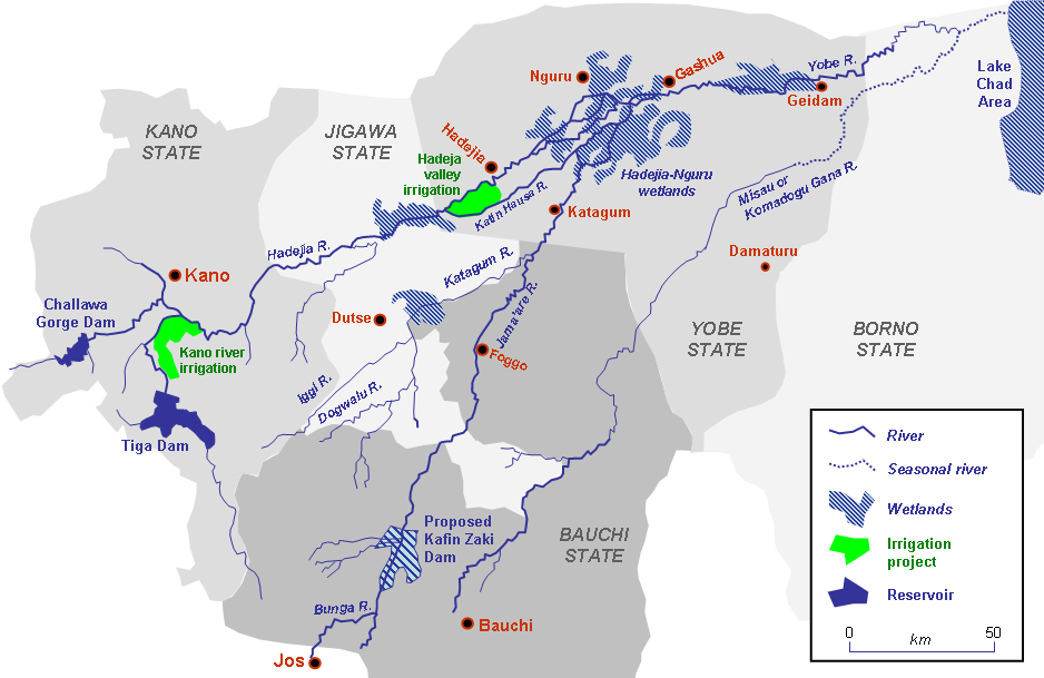
 Yobe River catchment area showing location of the Hadejia-Nguru wetlands
The Bade-Nguru Wetlands sector is part of the Hadejia-Nguru wetlands, and has an area of 938 km2 around coordinates 12°40′0″N 10°30′0″E / 12.666667°N 10.5°E. It lies in the southwest of the Bade and Jakusko Local Government Areas of Yobe State. The sector includes the Dagona Waterfowl Sanctuary, an important resting place for migratory birds.[1] It also includes five forest reserves.[8]
Annual rainfall ranges between 200-600 mm, during the period late May-September. With reduced flooding due to upstream dams and perhaps climate change, and with increasing population, the environment is degrading. There is growing competition between humans and wildlife. Farmers set out poison to kill the crop-destroying Quelea quelea, in the process killing non-target species. Marginal land is now coming under cultivation and tree cover in the forest reserves is being depleted.[9]
Bulatura sector
The Bulatura sector is in the Yusufari Local Government Area of Yobe State, and has an area of 92 km2 around coordinates 13°15′0″N 11°00′0″E / 13.25°N 11°E. The sector has a series of swampy valleys separated by scenic sand dunes. The valleys contain rich deposits of potash.[1]
References
- ^ a b c d "Chad Basin National Park". Nigeria National Park Service. http://nigeriaparkservice.org/chad/Default.aspx. Retrieved 2010-11-03.
- ^ Rod East, International Union for Conservation of Nature and Natural Resources. Antelope Specialist Group (1999). African antelope database 1998. IUCN. p. 54. ISBN 2831704774. http://books.google.ca/books?id=59Ci3C8BCmEC&pg=PA54.
- ^ a b Caterina Batello, Marzio Marzot, Adamou Harouna Touré, Peter Ervin Kenmore (2004). The future is an ancient lake: traditional knowledge, biodiversity and genetic resources for food and agriculture in Lake Chad Basin ecosystems. UN Food & Agriculture Organization. ISBN 9251050643. http://books.google.ca/books?id=P1lNboNEnQ0C&pg=PA241ff.
- ^ Lizzie Williams (2008). "Chad Basin National Park". Nigeria: the Bradt travel guide. Bradt Travel Guides. p. 280. ISBN 1841622397. http://books.google.ca/books?id=fwuQ71ZbaOcC&pg=PA280.
- ^ "Chad Basin National Park: Chingurmi - Duguma Sector". BirdLife International. http://www.birdlife.org/datazone/sitefactsheet.php?id=6737. Retrieved 2010-11-03.
- ^ J. J. Blanc, IUCN--The World Conservation Union (2007). African elephant status report 2007: an update from the African Elephant Database. IUCN. pp. 210–212. ISBN 2831709709. http://books.google.ca/books?id=t6tcxXz80XsC&pg=PA210.
- ^ Curt Meine, George Archibald (1996). The cranes: status survey and conservation action plan. IUCN. p. 45. ISBN 2831703263. http://books.google.ca/books?id=TUFH4RDiU6AC&pg=PA45.
- ^ Michele L. Thieme (2005). "Lake Chad Catchment". Freshwater ecoregions of Africa and Madagascar: a conservation assessment. Island Press. p. 194. ISBN 1559633654. http://books.google.ca/books?id=3nkL9NqqlscC&pg=PA194.
- ^ "Important Bird Area factsheet: Hadejia-Nguru wetlands, Nigeria". BirdLife International. http://www.birdlife.org/datazone/sitefactsheet.php?id=6754. Retrieved 2009-10-04.
Protected areas of Nigeria Forest Reserves Afi River • Akure • Akure Ofosu • Edumanom • Idanre • Ise • Ngel Nyaki • Oba Hills • Okeluse • Okomu • OluwaGame Reserves Borgu • Kashimbila • Ohosu • ZugurmaNational Parks Other Afi Mountain Wildlife Sanctuary • Mbe Mountains Community ForestCategories:- IUCN Category II
- National parks of Nigeria
- Borno State
- Yobe State

Wikimedia Foundation. 2010.