- Lye / Wollescote Cemetery
-
Lye / Wollescote Cemetery Details Year established 1879 Country England Location Cemetery Road, Lye, Stourbridge, West Midlands, DY9 2AN Coordinates 52°27′11″N 2°06′54″W / 52.4531523°N 2.1151149°WCoordinates: 52°27′11″N 2°06′54″W / 52.4531523°N 2.1151149°W
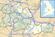

Owned by Dudley Metropolitan Borough Council Size 9.45 acres (3.82 ha) Website www.dudley.gov.uk Find a Grave www.findagrave.com The Lye / Wollescote Cemetery is an active 9.45 acres (3.82 ha) cemetery in Lye, West Midlands, England.[1]
Contents
History
The cemetery was opened in 1879 by the Lye and Wollescote Burial Board and was taken over by Dudley Metropolitan Borough Council in 1933.[1]
Chapel
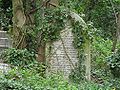
The "Lye and Wollescote Chapel" in the centre of the cemetery was originally called the "Mortuary Chappel". It is a Grade II listed pair of chapels built in 1879.[2] They are now derelict.[3]
Cemetery Road
The cemetery gave its name to "Cemetery Road" which runs along its front boundary and in which can be found the Holly Bush, one of the oldest pubs in Lye, and the rear of the grounds of Lye Cricket Club.[4]
External links
References
- ^ a b "Lye / Wollescote Cemetery". West Midlands, England: Dudley Metropolitan Borough Council. 2009-05-13. http://www.dudley.gov.uk/community-and-living/deaths-funerals--cremations/burials--graves/cemeteries--crematoriums-within-the-borough/lye--wollescote-cemetery. Retrieved 13 February 2010.
- ^ "Lye & Wollescote Cemetery Chapels". WhereCanWeGo.com. 2008-09-14. http://www.wherecanwego.com/Search/ViewEvent.aspx?e=220045&h=West+Midlands+Lye+%26+Wollescote+Cemetery+Chapels. Retrieved 13 February 2010.
- ^ "Ecology Based Projects". Land Care Associates. http://www.landcare.org.uk/ecologyprojects.html. Retrieved 13 February 2010.
- ^ Rye Cricket Club on Wikimapia
Cemeteries in England General Aldershot Military (Village) • Allerton • Anfield • Arnos Vale • Ascension Parish • Bishopwearmouth • Brandwood End • Brookwood • Cannock Chase • Carleton • City Road • Crookes • Everton • Ford Park • Gildencroft Quaker • Greenhaven Woodland • Hamilton Road • Harrogate (Stonefall) • Holywell • Jesmond • Key Hill • Layton • Linthorpe • Locksbrook • Lodge Hill • Mount • Norton • Osney • Rosary • Royal Burial Ground (Frogmore) • Sheffield General • Southampton Old • Southern • St Andrews Church • St James • St Sepulchre's • South Stoneham • St. Michael's • Tinsley Park • Toxteth Park • Warstone Lane • West Derby • Witton • Wolvercote • York
By city Brighton and Hove • LondonCategories:- Cemeteries in England
- Grade II listed buildings in the West Midlands
- 1879 establishments
- Death stubs


Wikimedia Foundation. 2010.