- Thornlie, Western Australia
-
Thornlie
Perth, Western Australia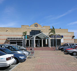
Thornlie Square shopping centre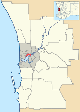
 Thornlie
Population: 22,265 (2006 census)[1] Established: 1956 Postcode: 6108 Area: 11.5 km² (4.4 sq mi) Location: 18 km (11 mi) SSE of Perth LGA: City of Gosnells State District: Gosnells, Cannington, Southern River Federal Division: Hasluck Suburbs around Thornlie: Langford Kenwick Maddington Parkwood Thornlie Gosnells Canning Vale Southern River Huntingdale Coordinates: 32°03′29″S 115°57′29″E / 32.058°S 115.958°E
Thornlie is a large outer suburb of Perth, Western Australia, located 18 kilometres south-east of Perth's central business district. It is part of the City of Gosnells local government area. The Canning River runs through the northern side of the suburb. The suburb contains the two smaller sub-developments of Crestwood and Forest Lakes, the latter being approximately 20 years younger than the main Thornlie development.
Contents
History
Captain Peter Pegus was the original settler of the area which is now known as Thornlie, however back in 1829 when Pegus was granted the land, he called it 'Coleraine'.[2] Prior to this the area would have been used by the indigenous Noongar population. In 1834 his premises and belongings were burned in a fire that was to prove the end of his settlement.[3]
The name Thornlie came about when Walter Padbury financed a farm known as "Thornlie Park". This farm was established in 1884 by Frank and Amy James, Amy being a niece of Walter Padbury.[4]
The James family subsequently sold the estate which had been a productive dairy farm,[5] in 1937 to the mine-manager and investor, Nat Harper.[6][4] When Harper died in 1954, the 1,715-acre (6.94 km2) Thornlie estate was put up for auction in two lots.[7] 228 acres (0.92 km2) of Lot 1 were purchased by D. and M. O'Sullivan and by June 1956 the Gosnells Roads Board had provided approval for the development of the area.[7] By March 1957 40 houses had been completed and by May 1958 there were 100 occupied homes.[7] Thornlie thus as a residential suburb was established in the late 1950s as a housing estate aimed mainly at middle-income earners and inner city dwellers.[7]
The first homes in the area included a section of residences constructed in the 1950s and early 1960s which lie to the north of the intersection of Thornlie Avenue and Spencer Road, and residences lying to the south of Thornlie Avenue between Spencer Road and the Canning River which were constructed in the 1960s and 1970s. During this time Thornlie development focus was on a getting out of town. It was aimed at inner city dwellers who might want to live in the more spacious surround that a semi-urban rural setting could offer. It is one reason why Thornlie has typically large quarter-acre blocks and is often described as one of Perth's ‘Leafy Suburbs’.
The more up-market Crestwood estate, which was an experiment in providing fully integrated facilities and services to home-owners, was established from the early 1970s in the southern part of Thornlie; the experiment did not lead to these provisions becoming common on the part of land developers in Perth. From the 1980s the newer Castle Glen and Forest Lakes housing estates, which were at that time to some extent in competition with one another for land purchasers, were established in the remaining land in the western and south-western portions of Thornlie.[citation needed]. The focus of these developments was on providing affordable housing for new home buyers, often couples with families.
Some semi-rural land in the western portion, mainly utilised for horse agistment and chicken-farming, was developed in the early 2000s. At one time there were several industrial activities taking place in the north-western portion. The last of these to close, about 2004, was the Ingham chicken-processing factory, the site of which is currently being redeveloped as the Yale residential estate which will begin land sales in early 2006.[citation needed]
Facilities
 Roe Highway at the Nicholson Road Exit.
Thornlie can be described as a well serviced residential area. It is bisected by a main transport artery, Spencer Road, and is served by Roe Highway, via Nicholson Road. It has also been serviced as of August 2005, by a passenger railway service terminating at the Thornlie railway station. Commuting services run every 15 minutes between the city and Thornlie. Speaking at the time about the newly completed rail development, the Planning and Infrastructure Minister Alannah MacTiernan stated:
"As well as the station building, car park and railway line, the project included construction of an electrical sub-station at Beckenham, the Kenwick Tunnel, the rail bridge over the Canning River, and the traffic bridge at Spencer Road." [8]
Telephone services are provided by the Cannington & Maddington telephone exchange.[9]
Commercial and Retail
Thornlie contains two local shopping centres - Thornlie Square Shopping Centre which contains two supermarkets and a Post Office, and Forest Lakes Forum which also has two supermarkets and numerous small retailers. Thornlie Square was the larger of the two until a recent expansion of Forest Lakes Forum prompted by the growth of the Forest Lakes residential estate. Thornlie also contains Spencer Village, a smaller retail strip located next to Thornlie train station, and there is a small commercial centre in Spencer Road adjacent to Thornlie Square.
Sporting
Lawn Bowls, tennis courts, a skate park, swimming pool, gym, a library and an oval for cricket and football are all available for community usage.
Schools
- Australian Islamic College [10]
- Coolabaroo Neighbourhood Centre [11][12]
- Forest Crescent Primary School [11]
- Sacred Heart Primary School [13]
- South Thornlie Primary School [11]
- Thornlie Primary School [11]
- Thornlie Senior High School [14]
- Thornlie TAFE Campus [15]
- Yale Primary School [11]
Community
Thornlie has two local papers distributed fortnightly, The Comment News and the Gosnells Examiner. 107.3 Heritage FM is a volunteer run Radio station for Thornlie and the Shire of Gosnells as a whole.
“[107.3 FM] first went to air on 26th January 1998 and broadcasts a number of specialist programs profiling the community, local sports, youth issues and crime prevention as well as promoting local bands and Australian music in general. Heritage FM also provides a wide range of music programs produced and presented by local residents, ranging from rock, folk, classical and blues through to jazz, choral, gospel, punk and heavy metal.”
The kind of community activities promoted include:
- Quiz nights
- Heritage bush walking
- Sport events
- Competitions and activities at the skate park
- Acoustic music in the park
- Ladies golf and
- Christian outreach
Another community program are the annual Safe City awards including the Community Initiative Award, the Constable Peter Ball Memorial Youth Award and the Community Kids Award.
Demographics
The 2006 Census reported[16]
- Thornlie had 8,017 occupied dwellings. 31.1% of these were fully owned.
- 60.6% of Thornlie residents were born in Australia; 11.3% in England; 3% in New Zealand, and significant smaller percentages from Malaysia, India and Scotland.
- 18.8% of Thornlie residents spoke another language at home.
- 1,447 children were aged 0-4 years. This was second only to Canning Vale with 1,836 for all Perth suburbs.[17]
- The median weekly family income was $1,193, which compared with $1,171 in Australia as a whole.
Residential subdivisions
Thornlie contains three distinct residential subdivisions in addition to older portions which were not separately named.
Crestwood Estate
Crestwood is a small private estate within Thornlie. It was built very much as an experimental concept and was in stark contrast to the usual patterns of suburban development in Perth in the early 1970s. Paul Ritter was the designer of Crestwood, and his concepts of shared public space and neighbourhood aesthetics continue to be models for today’s privately built estates.
Where the planning approach at the time was for large blocks and linear roads, Crestwood had small blocks and curved roads. Every road that enters into the area flows out again at some point, with no cul-de-sacs being constructed. It is also possible to walk the entire way through the estate without needing to cross a road due to a system of paths and underpasses. Every house is connected to a public area of parkland, and a shared pool facility sits in the middle of the estate.
Originally, Crestwood was intended to be built to about five times the size that exists today. The entire estate would then feature around a large pool complex with main administration buildings and recreational area. However, the larger development did not go ahead and the land was used in the 1980s and 1990s for two more conventional subdivisions, Forest Lakes and Castle Glen Estates.
While a lot of the concepts used in Crestwood did not end up being used widely in later residential developments in Perth, many of the ideas behind them did influence developers. After Crestwood, developments tended to be built with non-linear road systems, smaller blocks and often focused around a central park or lake.
Forest Lakes and Castle Glen
Forest Lakes and Castle Glen were the last significant residential developments in Thornlie, commencing in the early 1980s. They occupied land which was originally intended to become part of Crestwood Estate but were aimed at a more mainstream market while incorporating a few principles of Crestwood's design.
Gallery
-

Thornlie Leisure Centre
-

Thornlie Library[18]
-

Tom Bateman Reserve
-

Baseball Park
References
- ^ Australian Bureau of Statistics (25 October 2007). "Thornlie (State Suburb)". 2006 Census QuickStats. http://www.censusdata.abs.gov.au/ABSNavigation/prenav/LocationSearch?collection=Census&period=2006&areacode=SSC52396&producttype=QuickStats&breadcrumb=PL&action=401. Retrieved 2008-10-05.
- ^ McDonald, Gil; Bill Cooper (April 1988). "Survey and Settlement". The Gosnells Story (1st edition ed.). City of Gosnells. pp. 9–12. ISBN 0-7316-2737-7.
- ^ McDonald, Gil; Bill Cooper (April 1988). "A Corner of the Colony". The Gosnells Story (1st edition ed.). City of Gosnells. p. 27. ISBN 0-7316-2737-7.
- ^ a b History of Suburb Names > Thornlie www.gosnells.wa.gov.au. Retrieved 12 June 2007.
- ^ McDonald, Gil; Bill Cooper (April 1988). "A District Transformed". The Gosnells Story (1st edition ed.). City of Gosnells. p. 139. ISBN 0-7316-2737-7.
- ^ Harper, Nathaniel White (1865 - 1954) Australian Dictionary of Biography, Online Edition, 2006. Retrieved 2007-06-12.
- ^ a b c d McDonald, Gil; Bill Cooper. "From Village to City". The Gosnells Story (1st edition ed.). City of Gosnells. pp. 229–230. ISBN 0-7316-2737-7.
- ^ Thornlie line and station opening a major milestone for public transport network www.pta.wa.gov.au. Retrieved 12 June 2007.
- ^ ADSL2+ for CANNINGTON (WA) Exchang
- ^ Australian Islamic College. Retrieved 18 November 2007.
- ^ a b c d e ALPHABETICAL LISTING OF WESTERN AUSTRALIAN SCHOOLS BY EDUCATION DISTRICT 18 November 2007. Retrieved 18 November 2007.
- ^ Coolabaroo Neighbourhood Centre Retrieved 18 November 2007. Archived September 15, 2007 at the Wayback Machine
- ^ Sacred Heart Primary School Retrieved 18 November 2007.
- ^ Thornlie Senior High School www.thornlieshs.det.wa.edu.au. Retrieved 18 November 2007.
- ^ Swan TAFE - Thornlie Campus. Retrieved 18 November 2007.
- ^ Australian Bureau of Statistics (25 October 2007). "Thornlie (State Suburb)". 2006 Census QuickStats. http://www.censusdata.abs.gov.au/ABSNavigation/prenav/LocationSearch?collection=Census&period=2006&areacode=SSC52396&producttype=QuickStats&breadcrumb=PL&action=401. Retrieved 2008-02-28.
- ^ Alison Batcheler, The West Australian, 2007-07-21.
- ^ Thornlie Library Retrieved 2007-04-15.
External links
Suburbs of the City of Gosnells | Perth | Western Australia Beckenham · Canning Vale · Gosnells · Huntingdale · Kenwick · Langford · Maddington · Martin · Orange Grove · Southern River · Thornlie
Categories:- Suburbs of Perth, Western Australia


Wikimedia Foundation. 2010.