- Ōtagawa Station
-
Ōtagawa Station太田川駅
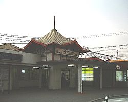
East Entrance (February 2002) Location Prefecture Aichi
(See other stations in Aichi)City Tōkai Neighborhood etc. 52 Ōta-machi Ushiroda Postal Code 477-0031 (in Japanese) 愛知県東海市大田町後田52 History Year opened 1912 Rail services Operator(s) Nagoya Railroad Line(s) Tokoname Line
Kōwa LineStatistics 13,243 passengers/day (2007)  Medium bus terminal at this station
Ōtagawa Station (太田川駅 Ōtagawa-eki) is a train station on the Meitetsu Tokoname Line and Kōwa Line which was opened by Aichi Electric Railroad on February 18, 1912,[1] but is now operated by Nagoya Railroad. It is located in Tōkai, Aichi, Japan.
Contents
Lines
Layout
Platforms
1 ■Meitetsu Kowa Line For Chita Handa, Kōwa, and Utsumi ■Meitetsu Tokoname Line For Tokoname (side line) 2 ■Meitetsu Tokoname Line For Tokoname and Central Japan International Airport ■Meitetsu Kowa Line For Kōwa and Utsumi 3 ■Tokoname Line For Jingū-mae, Meitetsu-Nagoya, Meitetsu-Gifu, Inuyama, Tsushima, and Toyohashi 4 ■Tokoname Line For Jingū-mae, Meitetsu-Nagoya, Meitetsu-Gifu, and Inuyama (side line) Adjacent stations
« Service » Meitetsu Tokoname Line Jingū-mae μSKY trains
(departing from Central Japan Int'l Airpot before 9 a.m.)Owari-Yokosuka Jingū-mae Limited Express (特急) Owari-Yokosuka Jingū-mae Rapid Express (快速急行) Owari-Yokosuka Ōe[2] Express (急行) Owari-Yokosuka Shinnittetsu-mae Local (普通) Owari-Yokosuka Meitetsu Kōwa Line (from Tokoname Line) Limited Express (特急) Chita Handa[3] (From Tokoname Line) Rapid Express (快速急行) Minami-Kagiya[4] (From Tokoname Line) Express (急行) Minami-Kagiya[4] (From Tokoname Line) Local (普通) Takayokosuka See Also
 Media related to Ōtagawa Station at Wikimedia Commons
Notes and references
External Links
- Official web page (Japanese)
Stations of the Meitetsu Tokoname Line・Meitetsu Airport Line・Meitetsu Chikkō Line Meitetsu Tokoname・Airport Line
Jingū-mae - Toyoda Honmachi - Dōtoku - Ōe - Daidōchō - Shibata - Nawa - Shūrakuen - Shinnittetsu-mae - Ōtagawa - Owari-Yokosuka - Teramoto - Asakura - Komi - Nagaura - Hinaga - Shin-Maiko - Ōnomachi - Nishinokuchi - Kabaike - Enokido - Taya - Tokoname - Rinkū-Tokoname - Central Japan International Airport
Meitetsu Chikkō Line
Ōe - Meiden-Chikkō - Higashi-NagoyakōStations of the Meitetsu Kōwa Line・Meitetsu Chita New Line (Meitetsu Kōwa Line)
Ōtagawa - Takayokosuka -Kagiya- Minami-Kagiya - Yawata Shinden - Tatsumigaoka - Shirasawa - Sakabe - Agui -Mukuoka- Uedai - Handaguchi - Sumiyoshichō - Chita-Handa - Narawa - Aoyama - Age - Chita-Taketoyo -Urashima- Fuki -Shikainami-Futto- Kōwaguchi -Tokishi- Kōwa
(Meitetsu Chita New Line)
Fuki - (Bessouike jct.) - Kaminoma - Mihama Ryokuen - Chita-Okuda - Noma -Onoura- UtsumiCoordinates: 35°01′13″N 136°53′33″E / 35.0203°N 136.8924°E
Categories:- Railway stations in Aichi Prefecture
- Railway stations opened in 1912
- Stations of Nagoya Railroad
- Aichi Prefecture railway station stubs

Wikimedia Foundation. 2010.