- Makhuduthamaga Local Municipality
-
Makhuduthamaga Local Municipality — Local municipality — Location in Limpopo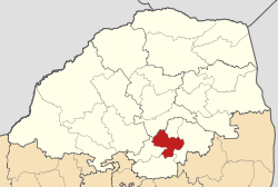
Coordinates: 24°45′S 29°45′E / 24.75°S 29.75°ECoordinates: 24°45′S 29°45′E / 24.75°S 29.75°E Country South Africa Province Limpopo District Sekhukhune District Seat Jane Furse Area - Total 2,096 km2 (809.3 sq mi) Population (2007)[1] - Total 262,726 - Density 125.3/km2 (324.6/sq mi) - Households 53,654 Racial makeup[2] (2007) - Black African 99.94% - White 0.00% - Coloured 0.01% - Indian or Asian 0.05% Time zone SAST (UTC+2) Municipal code LIM473 Website http://www.makhuduthamaga.gov.za/ Makhuduthamaga is a municipality in Sekhukhune District Municipality, Limpopo Province, South Africa.
The name is derived from the liberatory name given to those who supported the anti-apartheid struggle in Sekhukhuneland in the 1950s. Makhuduthamaga raged a war against the white commissioner and his assailants, Marentsara.[clarification needed]
References
- ^ "Community Survey, 2007: Basic Results Municipalities" (PDF). Statistics South Africa. http://www.statssa.gov.za/Publications/P03011/P030112007.pdf. Retrieved 2009-10-20.
- ^ "Community Survey 2007 interactive data". Statistics South Africa. http://www.statssa.gov.za/community_new/content.asp?link=interactivedata.asp. Retrieved 19 October 2009.
External links
Province of Limpopo, South Africa Provincial Capital: PolokwaneDistrict
and Local
MunicipalitiesGreater Giyani · Greater Letaba · Greater Tzaneen · Ba-Phalaborwa · MarulengBlouberg · Aganang · Molemole · Polokwane · Lepelle-NkumpiEphraim Mogale · Elias Motsoaledi · Makhuduthamaga · Fetakgomo · Greater TubatseCategories:- Local municipalities of Sekhukhune

Wikimedia Foundation. 2010.