- Nipmuck Trail
-
Nipmuck Trail 
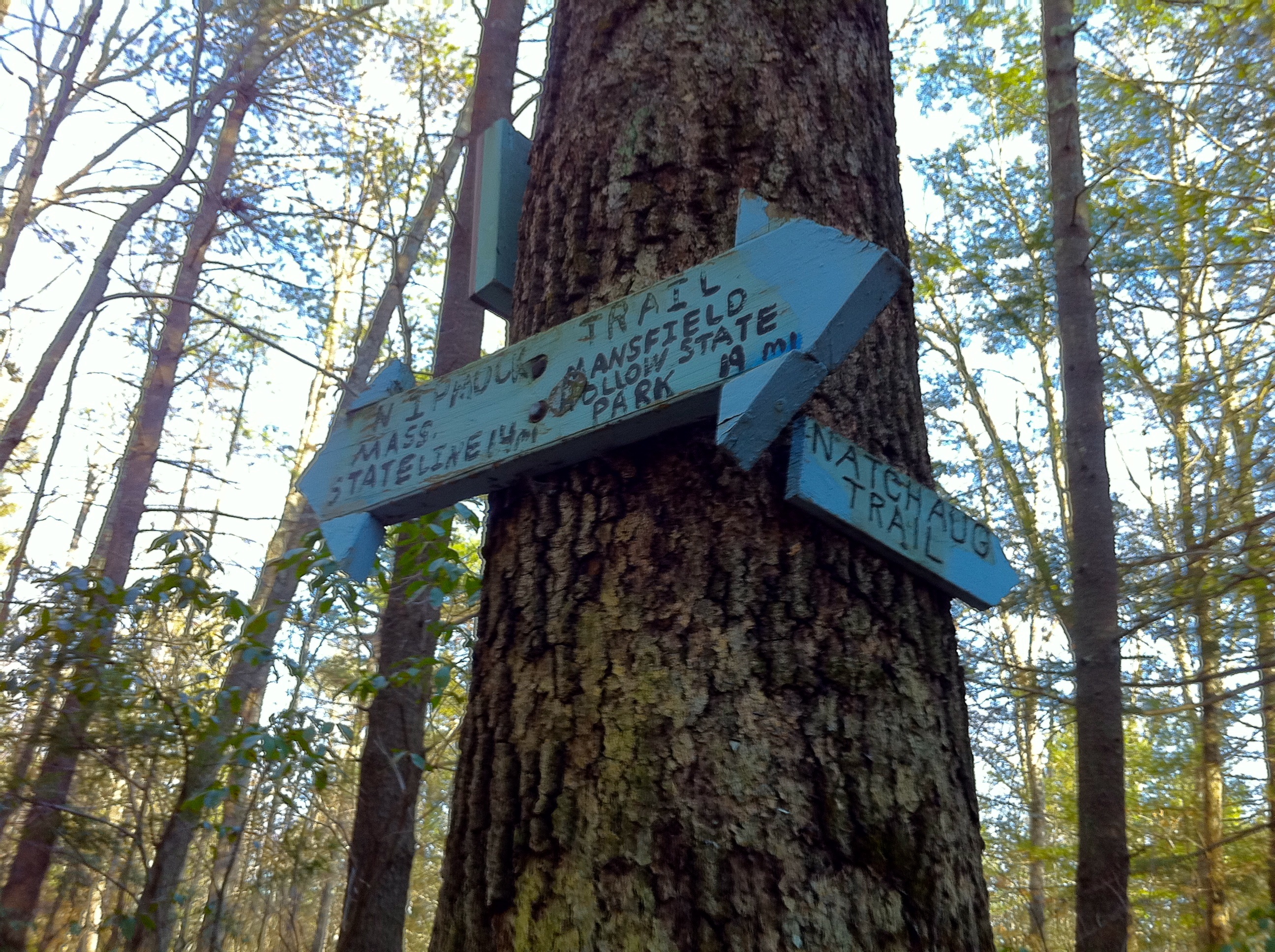
Nipmuck Trail sign on CT-171 outside Bigelow Hollow State Park. Length 34.5 miles (55.5 km) [1] Location Tolland County, Connecticut, USA Designation CFPA Blue-Blazed Trail Use hiking, cross-country skiing, snowshoeing, fishing, geocaching, other Hazards hunters, deer ticks, poison ivy The Nipmuck Trail is a Blue-Blazed hiking trail "system" which meanders through 34.5 miles (55.5 km) of forests in northeast Connecticut. It is maintained by the Connecticut Forest and Park Association and is considered one of the Blue-Blazed hiking trails. There are two southern trail heads (two tines of a fork) in the south of the town of Mansfield, Connecticut. The southwestern terminus is on Puddin Lane, the southeastern is in Mansfield Hollow State Park off Bassetts Bridge Road. The northern terminus is at the north end of Breakneck Pond along the Massachusetts border in Nipmuck State Forest. Camping permits may be obtained for up to five separate locations for backpacking.
For 9 miles (14 km) the Nipmuck Trail travels through the Yale-Myers Forest which is owned by Yale University. The trail also traverses 3.5 miles (5.6 km) of the University of Connecticut's East Campus (the protected Moss tract through the Fenton Forest).[2][3][4]
Contents
Trail description
The Nipmuck Trail is primarily used for hiking, backpacking, picnicking, and in the winter, snowshoeing.
Portions of the trail are suitable for, and are used for, cross-country skiing and geocaching. Site-specific activities enjoyed along the route include bird watching, hunting (very limited), fishing, horseback riding, bouldering and rock climbing (limited).
Trail route
Trail communities
The official Blue-Blazed Nipmuck Trail passes through land located within the following municipalities, from south to north:
Landscape, geology, and natural environment
 Pixie Falls in Natchaug State Forest in Ashford via side trail from Nipmuck Trail.
History and folklore
The Blue-Blazed Nipmuck Trail was created by the Connecticut Forest and Park Association.
Origin and name
Historic sites
Folklore
Hiking the trail
The mainline trail is blazed with blue rectangles. Trail descriptions are available from a number of commercial and non-commercial sources, and a complete guidebook is published by the Connecticut Forest and Park Association
Conservation and maintenance of the trail corridor
The last week of March 2010 the Connecticut Forest and Park Association acquired the largest conservation easement in an agreement with the University of Connecticut for the 3.5 miles (5.6 km) section of the Nipmuck Trail which passes through University of Connecticut protected property (the Moss tract through the Fenton Forest).[2] Also on that date a number of conveyances between the University of Connecticut, CFPA, the Norcross Wildlife Foundation and the towns of Willington and Mansfield secured the preservation of 531 acres (2.15 km2) of land on four forested properties near or surrounding the Nipmuck Trail.[3][4]
Recognition / Inspiration Programs
This trail system is a part of the 'Connecticut 400', one of the official Blue-Blazed (or similar) trails listed in the Connecticut Walk Book by the Connecticut Forest and Park Association (CFPA) and recognized, since 1976, with an award known as the Connecticut 400 Club by the Connecticut Chapter of the Appalachian Mountain Club (AMC). In 1976 there were only four hundred miles of Blue-Blazed trail but today (2010) the total length of the trails listed in the CFPA Connecticut Walk Books (East and West) exceeds 825 miles.[5][6][7]
The State of Connecticut Department of Environmental Protection (CT DEP) Forestry Division provides two awards for locating and visiting "letterboxes" (similar to geocaches) in Connecticut's State Forests. The commemorative 'State Forest Centennial Patch' is available to those who complete five sponsored "letterbox" hikes (in each separate state forest you must hike the described route, find the "letterbox/cache" and record your visit in the "letterbox" book). The State Forest Centennial campaign dates to 2003 (the centennial of the first official state forest in Connecticut). A walking stick is available for those who complete the letterbox hike of all thirty-two (32) of the state forests. Many of the "Blue-Blazed" hiking trails in Connecticut travel through or near one or more of the State Forests, often very close to the sponsored (DEP) letterbox.[8]
Image gallery
 Nipmuck Trail sign on CT-171 outside Bigelow Hollow State Park.
 Nipmuck Trail sign on CT-171 outside Bigelow Hollow State Park.
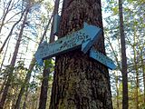 Natchaug Trail northern trailhead at intersection with Nipmuck Trail in Eastford, CT.
 Pixie Falls in Natchaug State Forest in Ashford via side trail from Nipmuck Trail.
 Pixie Falls in Natchaug State Forest in Ashford via side trail from Nipmuck Trail.
 Fenton River along Nipmuck Trail just north of CT Route44 (U Conn Forest).
 Fenton River along Nipmuck Trail just north of CT Route44 (U Conn Forest).
 Old stone house foundations at intersection of Nipmuck Trail and forest road half way between CT Routes 44 and 74.
 1' diameter fungus with peace sign on rock beside Nipmuck Trail in Yale-Myers Forest.
 Yale-Myers Forest Research Site off Nipmuck Trail.
 Southern Breakneck Pond on Nipmuck Trail facing north on the last day of winter.
 Yale-Myers Forest Signs and northern entrance to Nipmuck Trail on Bigelow Hollow Road AKA CT Route 197 near Bigelow Hollow State Park.
 Sturbridge Massachusetts end of partially frozen Breakneck Pond facing south. Northern terminus of Nipmuck Trail.
 Massachusetts/Connecticut state line marker dated 1954 at northern end of Breakneck Pond facing south.
 Connecticut/Massachusetts state line marker dated 1954 at northern end of Breakneck Pond facing north.
See also
- Blue-Blazed Trails
- Nipmuc
- Yale-Myers Forest
References
- ^ Colson, Ann T. (2006). Connecticut Walk Book West (19th edition). Connecticut Forest and Park Association. ISBN 0961905263.
- ^ a b The Daily Campus April 1, 2010: UConn helps to preserve local forest
- ^ a b UConn Today March 30, 2010: Deal Between Conservation Organizations, UConn, and Area Towns Protects 531 Acres in Eastern CT
- ^ a b The Day March 28, 2010: Agreement protects forest, trails near UConn
- ^ "The Connecticut 400". Rocks on Top. http://www.rocksontop.com/rocks/viewtopic.php?f=22&t=3408. Retrieved 2010-05-29.
- ^ Robinson, Ruth (1993-06-06). "Hikers Seek New Trails to Conquer". The New York Times. http://www.nytimes.com/1993/06/06/nyregion/hikers-seek-new-trails-to-conquer.html?sec=&spon=&pagewanted=all. Retrieved 2010-05-29.
- ^ "Hikes". Connecticut Museum Quest. http://www.ctmuseumquest.com/?page_id=23. Retrieved 2010-05-29.
- ^ "Forestry – Looking Beyond the Trees : Letterboxing in Connecticut's State Forests". Department of Environmental Protection, State of Connecticut. http://www.ct.gov/dep/cwp/view.asp?a=2697&q=322826&depNav_GID=1631. Retrieved 2010-05-29.
- Connecticut Forest & Park Association Cited September 13, 2008.
External links
Specific to this trail:
- Connecticut Explorers Guide: Nipmuck Trail Overview Map
- Connecticut Explorers Guide: Nipmuck Trail Southern Trailheads Map
- Connecticut Explorers Guide: Nipmuck Trail Southern Trails Junction to RT 74 Map
- HikeCT Nipmuck Trail page
Government Links:
Land and Conservation Trusts:
- Joshua's Tract Conservation and Historic Trust, Inc.
- Joshua's Tract/Tract Trails Walk Book
- Joshua's Tract/Trust Trail Maps
Further reading
- Books – Connecticut Hiking
- Colson, Ann (2005). Connecticut Walk Book East (19 ed.). Rockfall, Connecticut: Connecticut Forest and Park Association. pp. 1–261. ISBN 0961905255. http://books.google.com/books?id=x3vXPQAACAAJ.
- Colson, Ann (2006). Connecticut Walk Book West (19 ed.). Rockfall, Connecticut: Connecticut Forest and Park Association. pp. 1–353. ISBN 0961905263. http://books.google.com/books?id=5hZSAAAACAAJ.
- Emblidge, David (1998). Hikes in southern New England: Connecticut, Massachusetts, Vermont (1 ed.). Mechanicsburg, Pennsylvania: Stackpole Books. pp. 1–304. ISBN 0-8117-2669-X. http://books.google.com/books?id=H_4A-XrPYggC&lpg=PP1&pg=PP1#v=onepage&q&f=false.
- Keyarts, Eugene (2002). Pietrzyk, Cindi Dale. ed. Short Nature Walks: Connecticut Guide Book (7 ed.). Guilford, Connecticut: Falcon Publishing. pp. 1–192. ISBN 0-7627-2310-6. http://www.globepequot.com/isbn/0-7627-2310-6.
- Laubach, Rene; Smith, Charles W. G. (2007). AMC's Best Day Hikes in Connecticut (1 ed.). Guilford, Connecticut: Appalachian Mountain Club Books. pp. 1–320. ISBN 1-934028-10-X. http://www.globepequot.com/isbn/1-934028-10-X.
- Ostertag, Rhonda; Ostertag, George (2002). Hiking Southern New England (2 ed.). Guilford, Connecticut: Falcon Publishing. pp. 1–336. ISBN 0-7627-2246-0. http://www.globepequot.com/isbn/0-7627-2246-0.
- Books – Connecticut History and Geography
- De Forest, John (1853). History of the Indians of Connecticut from the earliest known period to 1850. Hartford, Connecticut: Wm. Jas. Hamersley. pp. 1–509. http://books.google.com/books?id=QysTAAAAYAAJ&dq=editions%3AHARVARD32044014634349&pg=PP1#v=onepage&q&f=false.
- Hayward, John (1857). New England Gazetteer: Containing Descriptions of the States, Counties, Cities and Towns of New England (2 ed.). Boston, Massachusetts: Otis Clapp. pp. 1–704. http://books.google.com/books?id=vMcMAAAAYAAJ&ots=qbWGmJHe8A&dq=New%20England%20Gazetteer%20states%20counties%20towns&pg=PR1#v=onepage&q=&f=false.
- Trumbull, Benjamin (1797). Volume One A Complete History of Connecticut - Civil and Ecclesiastical. Volume I (1818 printing ed.). New Haven, Connecticut: Maltby, Goldsmith & Co. and Samuel Wadsworth. pp. 1-1166. http://books.google.com/books?id=I2Z4ACHdrIoC Volume One.
- Trumbull, Benjamin (1797). Volume Two A Complete History of Connecticut - Civil and Ecclesiastical. Volume II (1818 printing ed.). New Haven, Connecticut: Maltby, Goldsmith & Co. and Samuel Wadsworth. pp. 1-1166. http://books.google.com/books?id=qwgWAAAAYAAJ&ots=N7363Fc8D4&dq=A%20Complete%20History%20of%20Connecticut%20-%20Civil%20and%20Ecclesiastical&pg=PR3#v=onepage&q&f=false Volume Two.
Coordinates: 41°45′56″N 72°13′03″W / 41.76556°N 72.2175°W
Hiking Trails in Connecticut Airline State Park Trail • Alain and May White Trails • American Legion • Appalachian Trail • Aspetuck Valley • Bigelow Hollow • Case Mountain • Charter Oak Greenway • Chatfield • Cockaponset • East Coast Greenway • Falls Brook • Farmington Canal Heritage Trail • Gay City • Hancock Brook • Hop River State Park Trail • Housatonic Range • Jericho • Kettletown • Lillinonah • Lone Pine • Macedonia Brook • Mattabesett • Mattatuck • McLean Game Refuge • Menunkatuck • Metacomet • Mohawk • Moosup Valley State Park Trail • Muir • Narragansett • Natchaug • Naugatuck • Nayantaquit • Nehantic • New England National Scenic Trail • Nipmuck • Old Furnace • Patchaug • Paugussett • Peoples • Pequot • Pine Knob • Pomperaug • Quinebaug • Quinnipiac • Ragged Mountain • Regicides • Salmon River • Saugatuck • Shenipsit • Sleeping Giant • Sleeping Giant State Park • Stony Creek Quarry • Sunny Valley Preserve • Tunxis • Washington–Rochambeau Revolutionary Route • Westwoods • Whitestone Cliffs • Wolcott Trail • Zoar

Protected areas of Connecticut National Park Service National Wildlife Refuges Silvio O. Conte • Stewart B. McKinney National Wildlife Refuge
National Trails State Parks Airline • Beckley Iron Furnace Industrial Monument • Bigelow Hollow • Black Rock • Bluff Point • Burr Pond • Camp Columbia • Campbell Falls • Chatfield Hollow • Collis P. Huntington • Connecticut Valley Railroad • Day Pond • Dennis Hill • Devil's Hopyard • Dinosaur • Fort Griswold Battlefield • Fort Trumbull • Gardner Lake • Gay City • George W. Seymour • Gillette Castle • Haddam Meadows • Haley Farm • Hammonasset Beach • Hampton Beach • Harkness Memorial • Haystack Mountain • Hop River State Park Trail • Hopeville Pond • Housatonic Meadows • Hurd • Indian Well • John A. Minetto • Kent Falls • Kettletown • Lake Waramaug • Larkin State Park Trail • Levy • Lovers Leap • Macedonia Brook • Mansfield Hollow • Mashamoquet Brook • Millers Pond • Mohawk Mountain • Moosup Valley State Park Trail • Mount Tom • Old Furnace • Osbornedale • Penwood • Putnam Memorial • Quaddick • Quinnipiac River • River Highlands • Rocky Neck • Selden Neck • Seth Low Pierrepont • Sherwood Island • Silver Sands • Sleeping Giant • Southford Falls • Squantz Pond • Stratton Brook • Talcott Mountain • Wadsworth Falls • West Rock Ridge • Wharton Brook • Windsor Locks Canal State Park Trail
State Forests Algonquin • American Legion • Centennial Watershed • Cockaponset • Enders • James L. Goodwin • Housatonic • Massacoe • Mattatuck • Meshomasic • Mohawk • Mohegan • Nassahegon • Natchaug • Nathan Hale • Nehantic • Nepaug • Nipmuck • Nye-Holman • Pachaug • Paugnut • People's • Pootatuck • Quaddick • Salmon River • Shenipsit • Topsmead • Tunxis • Wyantenock
Connecticut Department of Environmental Protection (web)Categories:- Hiking trails in Connecticut
- Protected areas of Tolland County, Connecticut
- Mansfield, Connecticut


Wikimedia Foundation. 2010.