- Cheetham Hill
-
For other uses, see Cheetham (disambiguation).
Coordinates: 53°30′14″N 2°13′52″W / 53.504°N 2.231°W
Cheetham Hill Cheetham 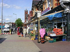
Cheetham Hill Road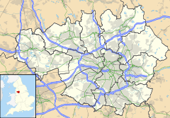
 Cheetham Hill
Cheetham Hill shown within Greater ManchesterPopulation 12,846 (2001 Census) OS grid reference SD846009 - London 164 mi (264 km) SE Metropolitan borough Manchester Metropolitan county Greater Manchester Region North West Country England Sovereign state United Kingdom Post town MANCHESTER Postcode district M8 Dialling code 0161 Police Greater Manchester Fire Greater Manchester Ambulance North West EU Parliament North West England UK Parliament Blackley and Broughton List of places: UK • England • Greater Manchester Cheetham Hill[1] is an inner city area of Manchester, England. As an electoral ward it is known as Cheetham and has a population of 12,846.[2][3] It lies on the west bank of the River Irk, 1.4 miles (2.3 km) north-northeast of Manchester city centre and close to the boundary with the City of Salford. Cheetham Hill is bounded by the neighbourhoods of Broughton, Crumpsall and Collyhurst, on the west, north and southeast respectively.
Historically a part of Lancashire, Cheetham Hill was originally a locality in Cheetham, a township within the parish of Manchester and hundred of Salford. The township of Cheetham was amalgamated into the then Borough of Manchester in 1838, and ceased to be a township in 1896 when it became part of the North Manchester township.[4][5]
Long existing as an industrial district, Cheetham Hill is the home of a multi-ethnic community, a result of several waves of immigration to Britain.[6] In the mid-19th century, Cheetham Hill attracted Irish people fleeing the Great Famine. Jews settled in Cheetham Hill during the late-19th and early-20th centuries, fleeing persecution in continental Europe. Migrants from the Indian subcontinent and Caribbean settled in the locality during the 1950s and 1960s. Since that time, Cheetham Hill has attracted people from Africa, Eastern Europe and the Far East, all contributing to a diverse, cosmopolitan community.[6]
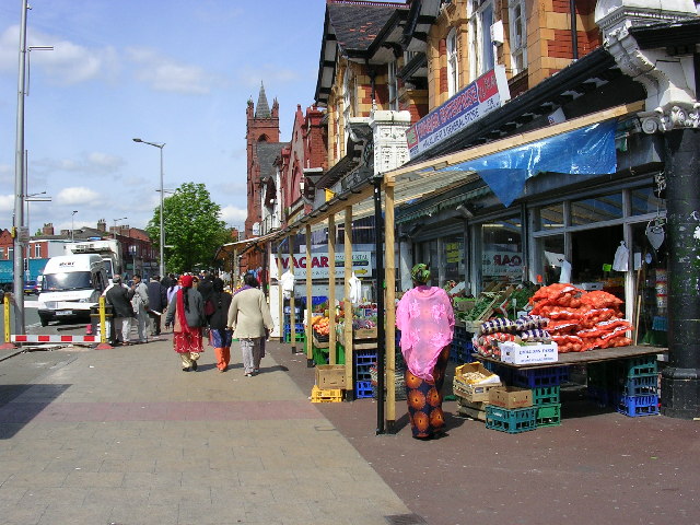
Heavily urbanised following the Industrial Revolution, Cheetham Hill today is bisected by Cheetham Hill Road, which is lined with churches, mosques, synagogues and temples, as well as terraced houses dating from Cheetham's history as a textile processing district. Joseph Holt's Brewery is on Empire Street, Cheetham. Markets along the road trade in wares and foodstuffs from all over the world.[6] The Museum of Transport in Manchester is located in Boyle Street, Cheetham Hill (former Queen's Road bus depot).
Contents
History
Further information: History of ManchesterNeolithic implements have been discovered at Cheetham Hill, implying human habitation 7–10,000 years ago.[7]
Unmentioned in the Domesday Book of 1086, Cheetham does not appear in records until 1212, when it was documented to have been a thegnage estate comprising "a plough-land", with an annual rate of 1 mark payable by the tenant, Roger de Middleton, to King John of England.[7] From the Middletons the estate of Cheetham passed to other families, including the Chethams and Pilkingtons.[7]
By the early 20th century, the southern end of Cheetham had a large Jewish population, and nine synagogues.[7] Michael Marks was a Jewish immigrant who lived in Cheetham Hill with his family. He and Thomas Spencer opened the first Marks and Spencer store on Cheetham Hill Road in 1893.[8] The business grew considerably over following years and in 1901 the companies first headquarters was built on Derby Street.[9]
During the Madchester phase of the history of Manchester, narcotic trade in the city became "extremely lucrative" and in the early 1980s a gang war started between two groups vying for control of the market in Manchester city centre - the Cheetham Hill Gang and The Gooch Close Gang, in Cheetham Hill and Moss Side respectively.[10] During this period Manchester acquired a reputation for gun crime, and was nicknamed "Gunchester" and the "Bronx of Britain" after a series of murders linked to turf wars and drug dealing associated with both Cheetham Hill and Moss Side.[11]
Governance
Further information: Politics in Manchester and Manchester City CouncilLying within the historic county boundaries of Lancashire since the early 12th century, Cheetham anciently constituted a thegnage estate, held by tenants who paid tax to the King.[7] Cheetham during the Middle Ages formed a township in the parish of Manchester, and hundred of Salford.[7] Governance continued on this basis until the Industrial Revolution, when Cheetham and the neighbouring Manchester Township had become suffiently urbanised and integrated to warrant an amalgamation into a single district: the then Borough of Manchester, in 1838.[4] There was a Cheetham Committee of Manchester Borough Council until 1875. Cheetham continued to hold the status of a township until 1896, when, together with Beswick, Blackley, Bradford, Clayton, Crumpsall, Harpurhey, Moston and Newton, it became part of the township of North Manchester.[4][5] North Manchester was a part of the City and County Borough of Manchester.
Following the Poor Law Amendment Act 1834, Cheetham formed part of the Manchester Poor Law Union from 1841 to 1850, Prestwich Poor Law Union from 1850 to 1915, and returned to Manchester Poor Law Union in 1915 until 1930. These were inter-parish units established to provide social security.[4]
Cheetham is an electoral ward of Manchester City Council[3] and is part of the Blackley and Broughton parliamentary constituency, the MP since 1997 is Graham Stringer of the Labour Party. Winston Churchill was Liberal MP for the area early in his political career (some years before he re-crossed the floor to the Conservative Party).
Geography
Further information: Geography of Greater Manchester
 Cheetham HillCheetham Hill, shown within Manchester.
At 53°30′14″N 2°13′51″W / 53.50389°N 2.23083°W (53.504°, -2.231°), and 164 miles (264 km) northwest of central London, Cheetham Hill is located above the midpoint of the Greater Manchester Urban Area, 1.4 miles (2.3 km) north-northeast of Manchester city centre. To the north, Cheetham Hill is bordered by Crumpsall, to the west by Broughton in Salford, to the east and south-east by Harpurhey and Collyhurst, and by Manchester city centre to the south.
Cheetham Hill lies on "rising ground",[12] and is completely urbanised.[7]
Demography
Further information: Demography of Greater ManchesterAccording to 2001 census the ethnic composition of Cheetham is:[3]
- White British - 43.34%
- White Irish - 3.43%
- White Other - 3.88%
- British Asian - 32.47%
- Black British - 5.62%
- Chinese or Other - 5.89%
- Mixed Race - 5.40%
Notable people
See also: List of people from Manchester- Jessie Fothergill, (1851–1891) novelist, was born in Cheetham Hill[13]
- Frances Hodgson Burnett — writer of The Secret Garden and A Little Princess was born in Cheetham Hill
- J. J. Thomson — English physicist who discovered the electron and won the Nobel Prize was born in Cheetham Hill
- Howard Jacobson — author, was born and raised in Cheetham Hill
- Abraham Hyman — survivor of the Titanic liner disaster, opened a delicatessen in Cheetham Hill, where it remains to this day[14]
- Jack Rosenthal — playwright, most famous for 'The Evacuees', 'Bar Mitzvah Boy', 'London's Burning' and early episodes of 'Coronation Street'
- Benny Rothman — political activist, famous for taking part in the Mass trespass of Kinder Scout in Derbyshire
- Don Arden — music promoter and manager of the Small Faces, ELO (born Harry Levy), father of Sharon Osbourne was born in Cheetham Hill
References
- ^ The Ordnance Survey records the placename as "Cheetham Hill". See:
Ordnance Survey. "Source data - 1:25,000 Scale Colour Raster; Grid reference at centre — SD 846 009 GB Grid". getamap.ordnancesurvey.co.uk. http://getamap.ordnancesurvey.co.uk/getamap/frames.htm?mapAction=gaz&gazName=g&gazString=SD8464900950. Retrieved 2008-11-01. - ^ Manchester City Council. "What's happening in Cheetham". manchester.gov.uk. http://www.manchester.gov.uk/site/scripts/documents_info.php?documentID=1680. Retrieved 2008-11-13.
- ^ a b c United Kingdom Census 2001 (2001). "Cheetham (Ward)". neighbourhood.statistics.gov.uk. http://neighbourhood.statistics.gov.uk/dissemination/LeadKeyFigures.do?a=7&b=6074491&c=Cheetham&d=14&e=15&g=351287&i=1001x1003x1004&m=0&r=1&s=1226620347259&enc=1. Retrieved 2008-11-13.
- ^ a b c d "Greater Manchester Gazetteer". Greater Manchester County Record Office. Places names - C. http://www.gmcro.co.uk/Guides/Gazeteer/gazzc.htm. Retrieved 17 October 2008.
- ^ a b Great Britain Historical GIS. "A vision of North Manchester CP". visionofbritain.org.uk. http://www.visionofbritain.org.uk/unit_page.jsp?u_id=10372288. Retrieved 2008-11-02
- ^ a b c "North Wards; Cheetham Hill" (PDF). northwards.net. December 2004. p. 9. http://www.northwards.net/files/finished.pdf.
- ^ a b c d e f g Brownbill 1911, pp. 259–262.
- ^ "Cheetham Hill". Manchester City Council. http://www.spinningtheweb.org.uk/m_display.php?irn=6&sub=cottonopolis&theme=places&crumb=Cheetham+Hill. Retrieved 10 March 2011.
- ^ "Marks and Spencer's Yorksjire roots". Genealogist. http://www.thegenealogist.co.uk/featuredarticles/jun10_mands.php. Retrieved 10 March 2011.
- ^ "A street guide to gangs in Manchester". bbc.co.uk. 2003-01-06. http://www.bbc.co.uk/manchester/have_your_say/2003/01/06/gangs.shtml. Retrieved 2008-11-14.
- ^ Chapman, Andrew; Keith (2006-06-11). "Tragedy of gun girl, 15". dailymail.co.uk. http://www.dailymail.co.uk/news/article-390089/Tragedy-gun-girl-15.html. Retrieved 2008-11-14.
- ^ Lewis 1848, pp. 562–569.
- ^ Oxford Dictionary of National Biography Retrieved on 24 September 2008
- ^ About Titanics ltd
The City of Manchester About Manchester Architecture · (Tallest buildings · Grade I buildings) · Cuisine · Culture · Economy · History · Media · (Television programmes) · Music · (Pop music) · People · Politics · Science · Sociology · Sport · Streets · Symbols · TransportDistricts Ancoats · Ardwick · Ardwick Green · Baguley · Belle Vue · Benchill · Beswick · Blackley · Bradford · Burnage · Castlefield · Cheetham Hill · Chinatown · Chorlton-cum-Hardy · Chorlton-on-Medlock · Chorltonville · City Centre · Clayton · Collyhurst · Crumpsall · Didsbury · Fallowfield · Gay Village · Gorton · Harpurhey · Hulme · Levenshulme · Longsight · Lower Crumpsall · Miles Platting · Moss Side · Moston · Newall Green · New Islington · New Moston · Newton Heath · Northenden · Northern Moor · Northern Quarter · Openshaw · Peel Hall · Piccadilly Village · Ringway · Rusholme · Sharston · Spinningfields · Whalley Range · Withington · Woodhouse Park · WythenshaweCategories:- Districts of Manchester
- UK locations with ethnic minority-majority populations
- Manchester City Council Wards


Wikimedia Foundation. 2010.