- New Idria, California
-
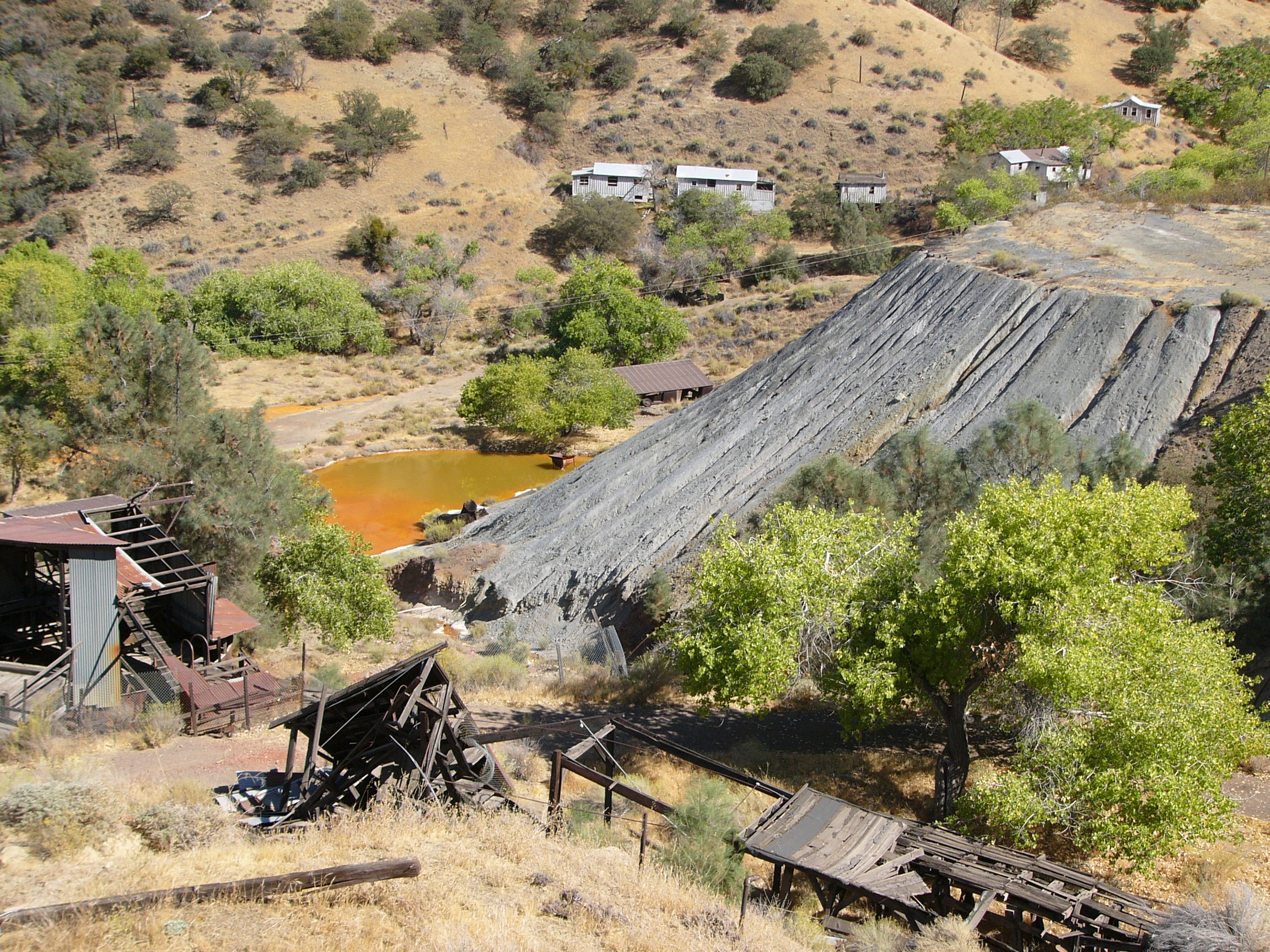
 New Idria grounds, 2004
New Idria was an unincorporated town in San Benito County, California. It is named after a now-inoperative quicksilver mine of the same name. The mine itself was named in honor of the world's second largest quicksilver mine in Idrija, Slovenia (Slovene pronunciation [ĭdrija]; California English pronunciation [īdria].)[1] The town grew to support the mining operations, but the mine closed in the 1970s. The town is currently an abandoned ghost town with more than 100 standing buildings, though vandalism has contributed to their deterioration in recent years.
According to the US Geological Survey, Idria (primary) and New Idria (variant) are both official names recognized for federal use in describing this community. Located in San Benito County, a feature ID Number of 1660786 has been assigned. The community is defined by the US Geological Survey as a populated place at 2,440 feet (608 m) AMSL elevation. NAD27 latitude and longitude are listed at 36°25′01″N 120°40′24″W / 36.41694°N 120.67333°W on the "Idria, California" 7.5-minute quadrangle (map).[2] The US Census Bureau flags the area with a "rural" indicator. Commercial road maps often identify the community as New Idria. The community is inside area code 831.
The US Postal Service agrees with the use of New Idria as name and includes the community in ZIP code 95043. The same ZIP code is shared with several other nearby communities.[3]
Contents
History
 A part of a mercury extraction plant of the New Idria Quicksilver Mining Company
The community was established to support the mine, which mainly extracted mercury, since cinnabar was abundant in the local rock formations. The history of mercury mining at the location begins in 1854. At one time, the New Idria mines were America's second most productive mines, with the New Almaden mines in the vicinity of San Jose, about 82 miles (132 km) northwest, being the first.[4]
The discovery of mercury ore at New Idria came soon after the discovery of gold in the Sierra foothills, which began the California gold rush. At that time, mercury was a key component in extracting gold from gold ore. Before New Idria and New Almaden, the mercury came almost exclusively from Europe.[4]
The New Idria Mining Company was formed soon after the discovery of cinnabar (quicksilver ore) in the southern Diablo Range of central California in 1854. The town of New Idria began around 1857 and about 300 men were employed at the mine by 1861. The first school opened in 1867 and the New Idria Post Office opened in 1869, with Edward A. Morse as the first postmaster.[5] In 1894, the New Idria Post Office dropped the word "New" and the town become known as Idria.[6] The New Idria Quicksilver Mining Company closed in 1972 and the town has since become a ghost town.[4]
New Idria is a California Historical Landmark (#324)[4] and home of the world’s first Gould Rotary Furnace, which revolutionized ore processing technology worldwide.[7]
The New Idria Mining District is known for its abundance of rare minerals such as benitoite, named after the San Benito River. Gem quality benitoite is only found in this area of the world. New Idria is also home to serpentinite rock. Many thousands of tectonic events acting on the serpentinite have produced extensive deposits of short-fiber asbestos.[8]
On July 30, 2010, a fire destroyed 13 buildings on the north side of town.[9]
Politics
In the state legislature New Idria is located in the 12th Senate District, represented by Republican Anthony Cannella, and in the 28th Assembly District, represented by Democrat Anna M. Caballero. Federally, New Idria is located in California's 17th congressional district, which has a Cook PVI of D +17[10] and is represented by Democrat Sam Farr.
Nearby areas
The area is inside Area code 831. It is included in the Monterey Bay Unified Air Pollution Control District and the Panoche Elementary School District.[11] San Benito Mountain, elevation 5,241 feet (1,597 m), is located 3.6 miles (5.8 km) southeast. The nearest city is King City along US101.
Environmental concerns in the area
The New Idria Mercury Mine was initially investigated in the 1990s by the EPA, for possible inclusion on the EPA's National Priorities List, but the site did not rank high enough at that time to be listed. A site reassessment was begun in 2002, and an expanded site assessment begun in 2009, which was concluded in October 2010.[12] In March 2011, the EPA proposed New Idria to its National Priority List; public comments will be accepted until May 9, 2011, see [1] for more information and a link to the public docket. Elevated levels of mercury were found downstream of the town, as well as significant levels of mercury and other heavy metals found within tailings piles on the site. The region has a long history of mining, with asbestos and chromium being mined in addition to mercury; the EPA's 2004 Risk Assessment for the nearby Clear Creek Management Area identified 86 separate abandoned mines in the vicinity.[13] The natural rock formations in the area have been shedding asbestos-rich debris into stream valleys for millions of years[8] The average New Idria rock contains 5-15% volume percent short fiber asbestos.[8] The 2010 edition of Rand McNally's The Road Atlas labels the area immediately south of New Idria as an "Asbestos Hazard Area".
 360° in the center of the New Idria ghost town.
See also
Notes
- ^ http://www.new-idria.org/pronun.html
- ^ "National Geographic Names Database," US Geological Survey, 1995.
- ^ ZIP Code information was derived from year 2000 US Census data.
- ^ a b c d http://www.new-idria.org/
- ^ Salley, Harold E. (1991) History of California Post Offices, 1849-1990, p. 99. The Depot, ISBN 0-943645-27-1
- ^ http://www.new-idria.org/timeline/t1880.html
- ^ http://www.new-idria.org/details/gould_furnace.html
- ^ a b c Ross, M (2003). "History of asbestos discovery and use and asbestos related disease in context with the occurrence of asbestos within ophiolite complexes." Geological Society of America, special paper 373
- ^ http://www.gilroydispatch.com/printer/article.asp?c=267552
- ^ "Will Gerrymandered Districts Stem the Wave of Voter Unrest?". Campaign Legal Center Blog. http://www.clcblog.org/blog_item-85.html. Retrieved 2007-10-20.
- ^ Area Code and school information was derived from US Department of Education files.
- ^ New Idria superfund status at U.S. EPA
- ^ US EPA Atlas Asbestos Mine Fact Sheet, 2004
External links
Coordinates: 36°25′01″N 120°40′24″W / 36.416944°N 120.673333°W
Municipalities and communities of San Benito County, California Cities 
CDPs Aromas‡ | Ridgemark | Tres Pinos
Unincorporated
communitiesGhost
townNew Idria
Footnotes ‡This populated place also has portions in an adjacent county or counties
Categories:- Former settlements in San Benito County, California
- Companies based in San Benito County, California
- Ghost towns in California
- California Historical Landmarks
- Unincorporated communities in California
- Mining communities in California
- Mining in California
- Buildings and structures in San Benito County, California


Wikimedia Foundation. 2010.