- Bouvet Island
-
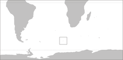
 Bouvet IslandLocation of Bouvet Island in the Atlantic Ocean
Bouvet Island Bouvetøya
Government Dependent territory - Monarch of Norway Harald V - Administration Polar Affairs Department Norwegian dependency - Claimed 1 December, 1927 - Annexed 23 January, 1928 - Dependency 27 February, 1930 - Nature reserve 17 December, 1971 Area - Total 49 km2
19 sq mi- Glaciated 93% Population - census uninhabited Time zone Standard: UTC+0[1]
DST: UTC+0[1]ISO 3166 code BV Internet TLD .bv¹ 1 Currently not in use. Bouvet Island (Norwegian: Bouvetøya) is an uninhabited Antarctic volcanic island in the South Atlantic Ocean, 2,525 km[2] south-southwest of South Africa. It is a dependent territory of Norway and, lying north of 60°S latitude, is not subject to the Antarctic Treaty. The centre of the island is an ice-filled crater of an inactive volcano, known as the Wilhelm II Plateau.[3] It is the most remote island in the world.[4]
Contents
Geography
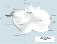 Map of Bouvet Island
Bouvet Island is located at 54°26′S 3°24′E / 54.433°S 3.4°E. It is 49 km2 (19 sq mi) in area, 93% of which is covered by glaciers, which block the south and east coasts.[5] A number of rocks and very small satellite islands lie offshore, including Lars Island to the southwest.
The nearest land is Queen Maud Land, Antarctica, which is over 1,750 kilometres (1,090 mi) away to the south, and which does not have a permanent population but is the site of a Norwegian all-year research station. To the northeast, it is about 2,500 kilometres (1,600 mi) to Cape Town.[3]
Bouvet Island has no ports or harbours, only offshore anchorages, and is therefore difficult to approach. Wave action has created a very steep coast. The easiest way to access the island is with a helicopter from a ship. The glaciers form a thick ice layer falling in high cliffs into the sea or onto the black beaches of volcanic sand. The 29.6 km (18.4 miles) of coastline are often surrounded by pack ice. The highest point on the island is called Olavtoppen, and has a peak 780 m (2,559 ft) above sea level. A lava shelf on the island's west coast formed between 1955 and 1958 and provides a nesting site for birds.
Because of the harsh climate and ice-bound terrain, vegetation is limited to lichens and mosses. Seals, seabirds and penguins are the only vertebrate fauna. As such the island is part of the Scotia Sea Islands tundra ecoregion, along with South Georgia and the South Sandwich Islands, the South Shetland Islands and the South Orkney Islands.
Despite being uninhabited, Bouvet Island has the unused Internet country code top-level domain (ccTLD) .bv.[6] It also has an amateur radio prefix, 3Y, and a few amateur radio expeditions have travelled to the island to use it. There is no telephone country code or area code, no telephone connection (except through satellite) and no postal code nor postal distribution. Bouvet Island is according to Norwegian law in the UTC+01 time zone.
Climate
Bouvetoya has an ocean-moderated polar climate (Köppen ET), with temperatures not too far from 0°C all year round.
Climate data for Bouvet Island Month Jan Feb Mar Apr May Jun Jul Aug Sep Oct Nov Dec Year Average high °C (°F) 3
(37)4
(39)3
(37)2
(36)1
(34)0
(32)−1
(30)−1
(30)−1
(30)0
(32)1
(34)3
(37)1.2
(34.1)Average low °C (°F) 0
(32)0
(32)0
(32)0
(32)−2
(28)−4
(25)−5
(23)−5
(23)−5
(23)−3
(27)−2
(28)−1
(30)−2.3
(28.0)Source: CIA World Fact Book[7] History
 Southeast coast of Bouvet Island, 1898
 Aerial photo
Bouvet Island was probably discovered on January 1, 1739, by Jean-Baptiste Charles Bouvet de Lozier, who commanded the French ships Aigle and Marie.[8](p96) However, the island's position was not fixed accurately, having been placed eight degrees to the east, and Bouvet did not circumnavigate his discovery, so it remained unknown whether it was an island or part of a continent.[9]
In 1772, Captain James Cook left South Africa on a mission to find the island. However, when arriving at 54°S 11°E / 54°S 11°E, where Bouvet had said he sighted the island, nothing was to be seen. Captain Cook assumed that Bouvet had taken an iceberg for an island, and he abandoned the search.[10]
The island was not sighted again until 1808, when it was seen by James Lindsay, the captain of the Samuel Enderby & Sons whaler Snow Swan. Though he did not land, he was the first to fix the island's position correctly. Since this deviated greatly from the incorrect position previously recorded for Bouvet, it was initially assumed to be a different island and was named Lindsay Island. Only later was it established[citation needed] that Bouvet and Lindsay must be the same.
Captain Benjamin Morrell of the sealer Wasp claimed to have landed on Bouvet in December 1822 to hunt for seals, but his account is disputed.[8](p435)
On December 10, 1825, Captain Norris, master of the Samuel Enderby & Sons whalers Sprightly and Lively, landed on the island, named it Liverpool Island, and claimed it for the British Crown. Again, it was not known with certainty at the time that this was the same island found previously. He also reported sighting a second island nearby, which he named Thompson Island. No trace of this island now remains.
In 1898, the German Valdivia expedition of Carl Chun visited the island but did not land.
The first extended stay on the island was in 1927, when the Norwegian crew of the ship Norvegia stayed for about a month. The island was claimed for Norway by expedition leader Lars Christensen on 1 December 1927.[11] By a Royal Norwegian Decree of January 23, 1928, Bouvet Island (Bouvetøya in Norwegian) became a Norwegian Territory. The United Kingdom waived its claim in favour of Norway the following year. In 1930 a Norwegian act was passed that made the island a dependent area subject to the sovereignty of the Kingdom (but not a part of the Kingdom).
In 1964, an abandoned lifeboat was discovered on the island although its origin has never been determined.[12][13]
In 1971, Bouvet Island and the adjacent territorial waters were designated a nature reserve. During the 1950s and 1960s, there was some interest from South Africa to establish a weather station, but conditions were deemed to be too hostile. An automated weather station was, however, set up in 1977 by the Norwegians.
On September 22, 1979, a satellite recorded a flash of light (which was later interpreted as having been caused by a nuclear bomb explosion or natural event such as a meteor) in a stretch of the southern Atlantic Ocean between Bouvet Island and Prince Edward Islands. This flash, since dubbed the Vela Incident, is still not completely resolved.[14]
In 1994, the Norwegians constructed a field station – a container building of 36 square metres (388 square feet). On October 19, 2007, the Norwegian Polar Institute announced that the station was no longer visible on satellite photographs. Later investigations indicated that a landslide or ice avalanche swept the building off its foundations. A replacement station is being planned (2009). An unmanned weather station on the island is reportedly still intact.[15]
Fiction
- Bouvet is the setting of the 2004 movie Alien vs. Predator, in which it is referred to using its Norwegian name "Bouvetøya"[16] even though in the unrated edition of the film, a satellite focuses in on the island which is geographically situated in the approximate location of Peter I Island.
- The island figures prominently in the book A Grue of Ice (published in the US as The Disappearing Island), an adventure novel based on Tristan da Cunha, Bouvet, and the mythical Thompson Island, by Geoffrey Jenkins.[17]
- Bouvet features in the novel Warhead by Andy Remic.
- Bouvet features in the novel Batmans Schönheit by Heinrich Steinfest.
See also
- .bv (Internet top-domain code for Bouvet Island)
- ISO 3166-2:BV, an ISO country code standard
- List of islands of Norway
- Sub-antarctic islands
References
- ^ a b Time zone of Bouvet Island. Timegenie.com
- ^ http://www.distancefromto.net
- ^ a b "Scotia Sea Islands tundra (AN1103)". WWF. http://www.worldwildlife.org/wildworld/profiles/terrestrial/an/an1103_full.html.
- ^ "Global Volcanism Program". volcano.si.edu. http://www.volcano.si.edu/world/region.cfm?rnum=18&rpage=highlights. Retrieved November 25, 2010.
- ^ "CIA - The World Factbook - Bouvet Island". CIA. 2007-01-14. https://www.cia.gov/library/publications/the-world-factbook/geos/bv.html.
- ^ "Norid: .bv and .sj domains are not in use". Norid. 2007-01-14. http://www.norid.no/domenenavnbaser/bv-sj.html.
- ^ "Monthly Averages for Bouvet Island". Climate Zone. 2011. http://www.climate-zone.com/climate/bouvet-island/celsius/bouvet-island.htm. Retrieved 2011-1-1.
- ^ a b Mills, William James (2003). Exploring Polar Frontiers: a historical encyclopedia, Volume 1. ABC-CLIO. ISBN 1576074226. http://books.google.co.uk/books?id=PYdBH4dOOM4C&pg=PA435.
- ^ "Bouvet Island". worldstats.org. 2007-01-14. Archived from the original on 2008-05-08. http://web.archive.org/web/20080508191713/http://www.worldstats.org/world/bouvet_island.shtml.
- ^ Boudewijn Buch - Eilanden (holland, 1991)
- ^ "Polar Pioneers: Hjalmar Riiser-Larsen". PolarFlight Online--North Polar Regions News and Information Magazine. 2007-07-05. http://polarflight-online.tripod.com/polarpers3.htm.
- ^ "MISR Image: Bouvet Island". NASA. 2007-01-14. http://eosweb.larc.nasa.gov/HPDOCS/misr/misr_html/bouvet_island.html.
- ^ "An abandoned lifeboat at world's end". A Blast From The Past. 2011-02-13. http://allkindsofhistory.wordpress.com/2011/02/13/an-abandoned-lifeboat-at-worlds-end/.
- ^ Alan Bellows (2007-10-22). "The Vela Incident". DamnInteresting.Com. http://www.damninteresting.com/?p=922.
- ^ "Norwegian field station gone with the wind". Norwegian Institute of Polar Research. 2007-10-19. http://npweb.npolar.no/Artikler/2007/1192800802.58.
- ^ IMDB article on Alien vs. Predator
- ^ Jenkins, Geoffrey. 1962. A Grue of Ice London: Collins. 320pp.
Further reading
- LeMasurier, W. E.; Thomson, J. W. (eds.) (1990). Volcanoes of the Antarctic Plate and Southern Oceans. American Geophysical Union. pp. 512 pp. ISBN 0-87590-172-7.
External links
Wikimedia Atlas of Bouvet Island
- Satellite map of Bouvet Island on BlooSee
- Information on Bouvet Island
- Bouvet Island entry at The World Factbook
- Bouvet Island - Bouvetøya
- Investigation into Bouvet's abandoned lifeboat mystery
- Bouvet Island at Infoplease
- 2000 Bouvet Island amateur radio expedition (3YØC)
- 1990 Bouvet Island amateur radio expedition (3Y5X)
Coordinates: 54°26′S 3°24′E / 54.433°S 3.4°E
Integral overseas areas and dependencies of Norway Integral territories Dependent territories Bouvet Island · Peter I Island · Queen Maud Land
Peri-Antarctic countries and overseas territories  "Peri-Antarctic" (meaning "close to the Antarctic") does not include territorial claims on Antarctica itself.
Outlying territories of European countries Territories under European sovereignty but closer to or on continents other than Europe (see inclusion criteria for further information)Denmark France Italy Netherlands Norway Portugal Spain United
KingdomAnguilla · Bermuda · British Virgin Islands · Cayman Islands · Falkland Islands · Montserrat · Saint Helena, Ascension and Tristan da Cunha · Turks and Caicos Islands · British Antarctic Territory · British Indian Ocean Territory · Pitcairn Islands · South Georgia and the South Sandwich IslandsCategories:- Bouvet Island
- Uninhabited islands of Norway
- Ridge volcanoes
- Inactive volcanoes
- Volcanoes of Norway
- Volcanoes of the Southern Ocean
- States and territories established in 1928
- Antarctic region


Wikimedia Foundation. 2010.