- N20 road (Ireland)
-
N20 road
Route information Length: 93 km (58 mi) Location Primary
destinations:(bypassed routes in italics)
- County Limerick
- Limerick City
- Dooradoyle
- Raheen
- Patrickswell
- Croom
- Rockhill
- County Cork
- Charleville
- Buttevant
- Newtwopothouse
- Mallow
- Ballynamona
- Blarney
- Killeens Cross
- Cork
Road network The N20 road is a national primary road in Ireland, connecting the cities of Cork and Limerick. Buttevant, Croom, Charleville, Mallow and Blarney are major towns along the route. Part of the route is a motorway, designated as the M20 Motorway.
Contents
Route
 N20 on the dual carriageway bypass into Limerick, approaching the exit for Dooradoyle. This section has been redesignated motorway, effective 28/8/09.
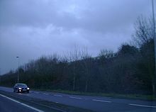 The N20 near Mallow. There is a short stretch of dual-carriageway before it reverts to the single-carriageway layout.
M20 Rosbrien Interchange (Limerick) to Patrickswell
The route starts at junction 1 at the Rosbrien interchange (south of Limerick City) where it connects to the M7 and the N18 which form the Limerick Southern Ring Road. The route continues from this interchange as motorway (see thumbnail). This route was redesignated as motorway in August 2009. The route bypasses Dooradoyle and Raheen, through which the old N20 route used to run until the early 2000s. Interchanges and link roads connect to these locations. Two further interchanges are located on the motorway, at either end of Patrickswell. At the latter, the M/N20 route leaves the main road (which continues as the N21 to Tralee), i.e. one must turn off the dual carriageway to stay on the M/N20.
N20 Patrickswell to Cork City
A wide two lane road brings traffic along the Croom bypass (prior to the opening of this bypass at a cost of €20 million on 12 July 2001, the route went through the town).[1] Past this new section of road, narrow two-lane road commences, ending at Charleville. The route passes through the town, running along Main Street. The road between Charleville and the next town, Buttevant is of similar design. At Mallow a relatively high specification road is encountered , with an older bypass of the town (early 1990s) passing up the hill from it as dual carriageway. A viaduct brings the road across the Blackwater River and Valley. The rest of the route to Cork is of high quality wide two lane, with a section of 2+1 road (a pilot installation) south of Mallow. The route becomes dual carriageway on the approach to Cork. New relief roads in Cork bring the route into the city centre while avoiding the winding streets through which the route ran until around 2000.
M20 motorway
 The M20 outside Limerick city approaching junction 2 northbound
 A distance sign on the M20
M20 motorway
Route information Part of 
Length: 8 km (5 mi)
Planned length: 90 km (56 mi)Existed: 2001 – present History: Postponed due to lack of funding Major junctions From: Rossbrien To: Attyflin Location Primary
destinations:Cork City, County Cork, Limerick Road network Under the government's collapsed Transport 21 initiative,[2] the Atlantic Corridor road project aimed to link Letterkenny to Waterford via Limerick and Cork with high quality roadway. A major part of this project involved the upgrading of the N20 route between Cork and Limerick.
It was proposed to upgrade or replace the entire N20 with a new M20 motorway, approximately 90 km (56 mi) in length, with up to eight newly constructed junctions or re-configured junctions. It was to be constructed in two stages: a southern section and a northern section.[3] It is hoped that this project will be progressed as a PPP scheme. Details of progress on the scheme can be found on the Cork National Roads Office website.[4]
The first segment of M20 motorway came into existence on 28 August 2009 following the approval by the Minister for Transport to redesignate a 10 km (6 mi) of existing N20 dual-carriageway between Rossbrien and Attyflin as motorway.[5]
On 10 November 2011, owing to funding issues caused by the current financial crisis in Ireland, the government announced that the planned completion of the M20 motorway is to be shelved for the foreseeable future, along with a number of other insfrastructural projects.
Junctions
M20 motorway Northbound exit Junction Southbound exit Dublin (M7  ), Limerick, Galway (N18)
Start of motorway Dooradoyle (R926) 
Dooradoyle(R926) Raheen(R510) 
Raheen(R510) Patrickswell(R526) 
Patrickswell(R526) Start of motorway — Cork, Mallow (N20) Tralee, Castleisland, Adare (N21)
M20 motorway (in planning) Northbound exit Junction Southbound exit Adare (N21), Croom — Adare (N21), Croom Bruree, Kilmallock (R518) — Bruree, Kilmallock (R518) Services Charleville, — Charleville, Buttevant — Buttevant Doneraile, Mallow East (N72) — Doneraile, Mallow East (N72) Mallow South — Mallow South Rathduff, Grenagh — Rathduff, Grenagh Blarney — Blarney Cork Northern Ring Road (N22) — Cork Northern Ring Road (N22) Cork — Cork See also
References
External links
- Roads Act 1993 (Classification of National Roads) Order 2006 – Department of Transport
- Mallow to Croom scheme
- M20 Cork to Limerick Motorway Scheme Public Consultation Brochure
Roads in Ireland Motorways National primary roads National secondary roads Regional roads (R101–R399) R101 · R102 · R103 · R104 · R105 · R106 · R107 · R108 · R109 · R110 · R111 · R112 · R113 · R114 · R115 · R116 · R117 · R118 · R119 · R120 · R121 · R122 · R123 · R124 · R125 · R126 · R127 · R128 · R129 · R130 · R131 · R132 · R133 · R134 · R135 · R136 · R148 · R149 · R150 · R151 · R152 · R153 · R154 · R155 · R156 · R157 · R158 · R159 · R160 · R161 · R162 · R163 · R164 · R165 · R166 · R167 · R168 · R169 · R170 · R171 · R172 · R173 · R174 · R175 · R176 · R177 · R178 · R179 · R180 · R181 · R182 · R183 · R184 · R185 · R186 · R187 · R188 · R189 · R190 · R191 · R192 · R193 · R194 · R195 · R196 · R197 · R198 · R199 · R200 · R201 · R202 · R203 · R204 · R205 · R206 · R207 · R208 · R209 · R210 · R211 · R212 · R213 · R214 · R229 · R230 · R231 · R232 · R233 · R234 · R235 · R236 · R237 · R238 · R239 · R240 · R241 · R242 · R243 · R244 · R245 · R246 · R247 · R248 · R249 · R250 · R251 · R252 · R253 · R254 · R255 · R256 · R257 · R258 · R259 · R260 · R261 · R262 · R263 · R264 · R265 · R266 · R267 · R268 · R277 · R278 · R279 · R280 · R281 · R282 · R283 · R284 · R285 · R286 · R287 · R288 · R289 · R290 · R291 · R292 · R293 · R294 · R295 · R296 · R297 · R298 · R299 · R310 · R311 · R312 · R313 · R314 · R315 · R316 · R317 · R318 · R319 · R320 · R321 · R322 · R323 · R324 · R325 · R326 · R327 · R328 · R329 · R330 · R331 · R332 · R333 · R334 · R335 · R336 · R337 · R338 · R339 · R340 · R341 · R342 · R343 · R344 · R345 · R346 · R347 · R348 · R349 · R350 · R351 · R352 · R353 · R355 · R356 · R357 · R358 · R359 · R360 · R361 · R362 · R363 · R364 · R365 · R366 · R367 · R368 · R369 · R370 · R371 · R372 · R373 · R374 · R375 · R376 · R377 · R378 · R379 · R389 · R390 · R391 · R392 · R393 · R394 · R395 · R396 · R397 · R398 · R399Regional roads (R400–R699) R400 · R401 · R402 · R403 · R404 · R405 · R406 · R407 · R408 · R409 · R410 · R411 · R412 · R413 · R414 · R415 · R416 · R417 · R418 · R419 · R420 · R421 · R422 · R423 · R424 · R425 · R426 · R427 · R428 · R429 · R430 · R431 · R432 · R433 · R434 · R435 · R436 · R437 · R438 · R439 · R440 · R441 · R442 · R443 · R444 · R445 · R446 · R448 · R449 · R458 · R459 · R460 · R461 · R462 · R463 · R464 · R465 · R466 · R467 · R468 · R469 · R470 · R471 · R472 · R473 · R474 · R475 · R476 · R477 · R478 · R479 · R480 · R481 · R482 · R483 · R484 · R485 · R486 · R487 · R488 · R489 · R490 · R491 · R492 · R493 · R494 · R495 · R496 · R497 · R498 · R499 · R500 · R501 · R502 · R503 · R504 · R505 · R506 · R507 · R509 · R510 · R511 · R512 · R513 · R514 · R515 · R516 · R517 · R518 · R519 · R520 · R521 · R522 · R523 · R524 · R525 · R526 · R527 · R548 · R549 · R550 · R551 · R552 · R553 · R554 · R555 · R556 · R557 · R558 · R559 · R560 · R561 · R563 · R564 · R565 · R566 · R567 · R568 · R569 · R570 · R571 · R572 · R573 · R574 · R575 · R576 · R577 · R578 · R579 · R580 · R581 · R582 · R583 · R584 · R585 · R586 · R587 · R588 · R589 · R590 · R591 · R592 · R593 · R594 · R595 · R596 · R597 · R598 · R599 · R600 · R601 · R602 · R603 · R604 · R605 · R606 · R607 · R608 · R609 · R610 · R611 · R612 · R613 · R614 · R615 · R616 · R617 · R618 · R619 · R620 · R621 · R622 · R623 · R624 · R626 · R627 · R628 · R629 · R630 · R631 · R632 · R633 · R634 · R635 · R637 · R638 · R639 · R659 · R660 · R661 · R662 · R663 · R664 · R665 · R666 · R667 · R668 · R669 · R670 · R671 · R672 · R673 · R674 · R675 · R676 · R677 · R678 · R679 · R680 · R681 · R682 · R683 · R684 · R685 · R686 · R687 · R688 · R689 · R690 · R691 · R692 · R693 · R694 · R695 · R696 · R697 · R698 · R699Regional roads (R700–R940) R700 · R701 · R702 · R703 · R704 · R705 · R706 · R707 · R708 · R709 · R710 · R724 · R725 · R726 · R727 · R729 · R730 · R731 · R733 · R734 · R735 · R736 · R737 · R738 · R739 · R740 · R741 · R742 · R743 · R744 · R745 · R746 · R747 · R748 · R749 · R750 · R751 · R752 · R753 · R754 · R755 · R756 · R757 · R758 · R759 · R760 · R761 · R762 · R763 · R764 · R765 · R766 · R767 · R768 · R769 · R770 · R772 · R773 · R774 · R801 · R802 · R803 · R804 · R805 · R806 · R807 · R808 · R809 · R810 · R811 · R812 · R813 · R814 · R815 · R816 · R817 · R818 · R819 · R820 · R821 · R822 · R824 · R825 · R826 · R827 · R828 · R829 · R830 · R831 · R833 · R834 · R835 · R836 · R837 · R838 · R839 · R840 · R841 · R842 · R843 · R846 · R847 · R848 · R849 · R851 · R852 · R853 · R854 · R855 · R857 · R858 · R859 · R860 · R863 · R864 · R865 · R866 · R867 · R868 · R870 · R871 · R873 · R874 · R875 · R876 · R877 · R880 · R883 · R884 · R885 · R886 · R887 · R888 · R889 · R890 · R891 · R895 · R896 · R898 · R899 · R900 · R901 · R902 · R903 · R904 · R906 · R907 · R908 · R909 · R910 · R911 · R913 · R914 · R915 · R916 · R917 · R918 · R919 · R920 · R921 · R922 · R923 · R924 · R925 · R926 · R927 · R928 · R929 · R930 · R931 · R932 · R933 · R934 · R935 · R936 · R937 · R940See also: National Development Plan · National Roads Authority · Local roads · Trunk roads Categories:- National primary roads in the Republic of Ireland
- Roads in County Limerick
- Roads in County Cork
- County Limerick


Wikimedia Foundation. 2010.