- Lichfield
-
Not to be confused with Litchfield (disambiguation).For other uses, see Lichfield (disambiguation).
Coordinates: 52°41′01″N 1°49′36″W / 52.6835°N 1.82653°W
City of Lichfield 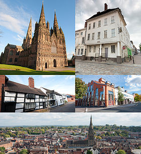
From top left: Lichfield Cathedral; Samuel Johnson Birthplace Museum; Quonians Lane; Garrick Theatre; Cityscape.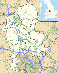
 City of Lichfield
City of Lichfield shown within StaffordshireArea 9.8 km2 (3.8 sq mi) Population 30,583 - Density 3,120 /km2 (8,100 /sq mi) OS grid reference SK115097 - London 124 miles (200 km) NNW Parish Lichfield District Lichfield Shire county Staffordshire Region West Midlands Country England Sovereign state United Kingdom Post town LICHFIELD Postcode district WS13 WS14 Dialling code 01543 Police Staffordshire Fire Staffordshire Ambulance West Midlands EU Parliament West Midlands UK Parliament Lichfield List of places: UK • England • Staffordshire Lichfield (
 /ˈlɪtʃfiːld/) is a cathedral city, civil parish[1] and district in Staffordshire, England. One of eight civil parishes with city status in England, Lichfield is situated roughly 25 km (16 mi) north of Birmingham. In 2008, its population was estimated at 30,583 and the wider Lichfield district at 97,900.[2]
Notable for its three-spired medieval cathedral, Lichfield was the birthplace of Samuel Johnson, the writer of the first authoritative Dictionary of the English Language. The city's recorded history began when St Chad arrived to establish his Bishopric in 669 CE and the settlement grew as the ecclesiastical centre of the Kingdom of Mercia. In 2009 the Staffordshire Hoard, the largest hoard of Anglo-Saxon gold and silver metalwork, was found 5.9 km (3.7 mi) south west of Lichfield.
The development of the city was consolidated in the 12th century under Bishop Clinton who fortified the Cathedral Close, and also laid out the town with the ladder-shaped street pattern that survives to this day. Lichfield's heyday was in the 18th century when it developed into a thriving coaching city. This was a period of great intellectual activity, the city being the home of many famous people including Samuel Johnson, David Garrick, Erasmus Darwin and Anna Seward, and prompted Johnson's remark that Lichfield was "a city of philosophers".
Today, the city still retains its old importance as an ecclesiastical centre, and its industrial and commercial development has been limited. The centre of the city retains an unspoilt charm with over 230 listed buildings in its historic streets, fine Georgian architecture and old cultural traditions.
Contents
Etymology
Legend has it that a thousand Christians were martyred in Lichfield around AD 300, during the reign of the Roman Emperor Diocletian, and that the name 'Lichfield' actually means 'field of the dead' (see Lich). There is however, no evidence to support this legend.[3] At Wall, 3.5 km (2.2 mi) to the south of the present city, there was a Romano-British village called Letocetum from the British (Celtic) for "grey wood", from which the first half of the name Lichfield is derived.[4] The second part of the name is derived from the Old English "feld", meaning 'open country'. In that sense 'Lichfield' would be 'common pasture in grey wood', 'grey' perhaps referring to varieties of tree prominent in the landscape, such as ash and elm.[5]
History
Prehistory and antiquity
Main article: LetocetumThe earliest evidence of settlement has been the discovery of Mesolithic flints on the high ground of St Michael’s churchyard, which may indicate an early flint industry. Traces of Neolithic settlement have been discovered on the south side of the sandstone ridge occupied by the Cathedral.[6]
3.5 km (2.2 mi) south west of Lichfield, near the point where Ryknild Street crosses Watling Street was the site of the Roman town of Letocetum. Established in 50 as a military fortress, by the 2nd century it had become a civilian settlement with a bath house and a mansio.[6] Letocetum fell into decline by the 4th century and the Romans had left by the 5th century. There have been scattered Romano-British finds in Lichfield, and it is possible that a burial discovered beneath the cathedral in 1751 was Romano-British.[6] There is no evidence as to what happened to Letocetum after the Romans left, however Lichfield may have emerged as its inhabitants relocated during its decline.
Middle Ages
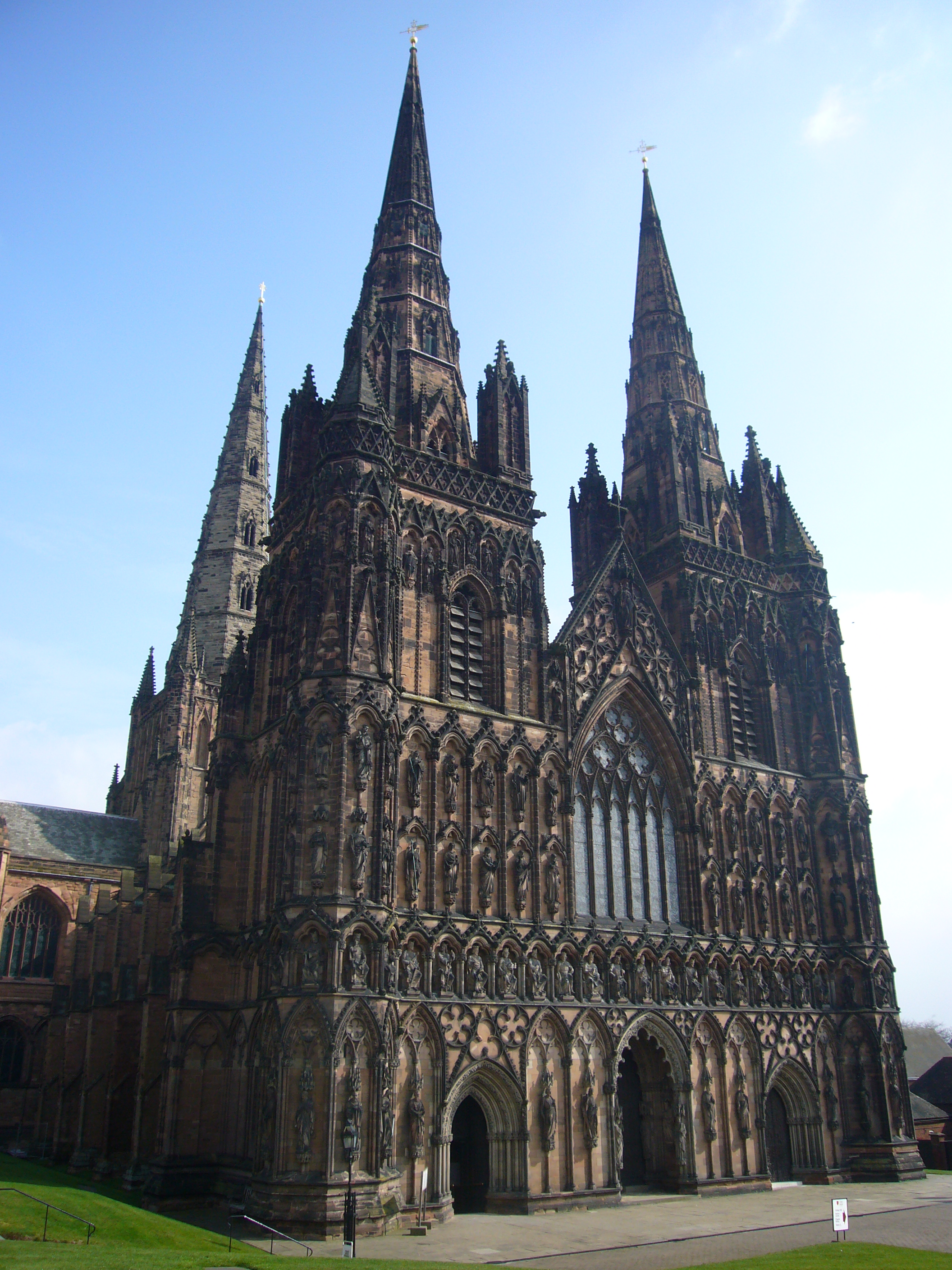
 The three spired cathedral was built between 1195 and 1249.
The early history of Lichfield is obscure. The first authentic record of Lichfield occurs in Bede's history, where it is called Licidfelth and mentioned as the place where St Chad fixed the episcopal see of the Mercians in 669. The first Christian king of Mercia, King Wulfhere donated land at Lichfield for Chad to build a monastery. It was because of this that the ecclesiastical centre of the Diocese of Mercia became settled at Lichfield, which was approximately 7 miles (11 km) north of the seat of the Mercian kings at Tamworth. The first cathedral to be built on the present site was in 700 when Bishop Hedda built a new church to house the bones of St Chad, which had become a sacred shrine to many pilgrims when he died in 672. The burial in the cathedral of the kings of Mercia, King Wulfhere in 674 and King Ceolred in 716, further increased the prestige of Lichfield.[7] In 786 Offa, King of Mercia, raised Lichfield to the dignity of an archbishopric, with authority over all the bishops from the Humber to the Thames. However after King Offa's death in 796, Lichfield's power waned and in 803 the primacy was restored to Canterbury by Pope Leo III after only 16 years. The Historia Britonum lists the city as one of the 28 cities of Britain around AD 833.
During the 9th century, the Kingdom of Mercia was devastated by the Vikings from Denmark. Lichfield itself was unwalled and the cathedral was despoiled, so Bishop Peter moved the see to the fortified and wealthier Chester in 1075.
 The Staffordshire Hoard was discovered in a field near Lichfield
His successor, Robert de Limesey, transferred it to Coventry, but it was eventually restored to Lichfield in 1148. Work began on the present Gothic cathedral in 1195. At the time of the Domesday survey, Lichfield was held by the bishop of Chester, where the see of the bishopric had been moved 10 years earlier; Lichfield was listed as a small village. The lord of the manor was the bishop of Chester until the reign of Edward VI.
Bishop Clinton was responsible for transforming the scattered settlements to the south of Minster Pool into the ladder plan streets we recognise today. Market Street, Wade Street, Bore Street and Frog Lane linked Dam Street, Conduit Street and Bakers Lane on one side with Bird Street and St John Street on the other. Bishop Clinton also fortified the cathedral close, enclosed the town with a bank and ditch, and gates were set up where roads into the town crossed the ditch.[7] In 1291 Lichfield was severely damaged by a fire, which destroyed most of the town, however the Cathedral and Close survived unscathed.[8] In 1387 Richard II gave a charter for the foundation of the gild of St Mary and St John the Baptist; this gild functioned as the local government, until its dissolution by Edward VI, who incorporated the town in 1548.
Early Modern
 Samuel Johnson was born in Breadmarket Street in 1709.
Henry VIII had a dramatic effect on Lichfield. The Reformation brought the disappearance of pilgrim traffic following the destruction of St Chad's shrine in 1538 which was a major loss to the city's economic prosperity. That year too the Franciscan Friary was dissolved, the site becoming a private estate. Further economic decline followed the outbreak of plague in 1593, which resulted in the death of over a third of the entire population.[9]
Three people were burned at the stake for heresy under Mary I. The last person in England to meet this fate was in Lichfield. Edward Wightman from Burton upon Trent was executed by burning in the Market Place on 11 April 1612 for his activities promoting himself as the divine Paraclete and Savior of the world.[10][11]
In the English Civil War, Lichfield was divided. The cathedral authorities, with a certain following, were for the king, but the townsfolk generally sided with the Parliament. This led to the fortification of the close in 1643. Lichfield's position as a focus of supply routes had an important strategic significance during the war, and both forces were anxious for control of the city. Lord Brooke, notorious for his hostility to the church, led an assault against it, but was killed by a deflected bullet on St Chad's day, an accident welcomed as a miracle by the Royalists. The close yielded and was retaken by Prince Rupert of the Rhine in this year; but on the breakdown of the king's cause in 1646 it again surrendered. The cathedral suffered extensive damage from the war, including the complete destruction of the central spire. It was subsequently restored at the end of the Commonwealth period under the supervision of Bishop Hacket, and thanks in part to the generosity of King Charles II.
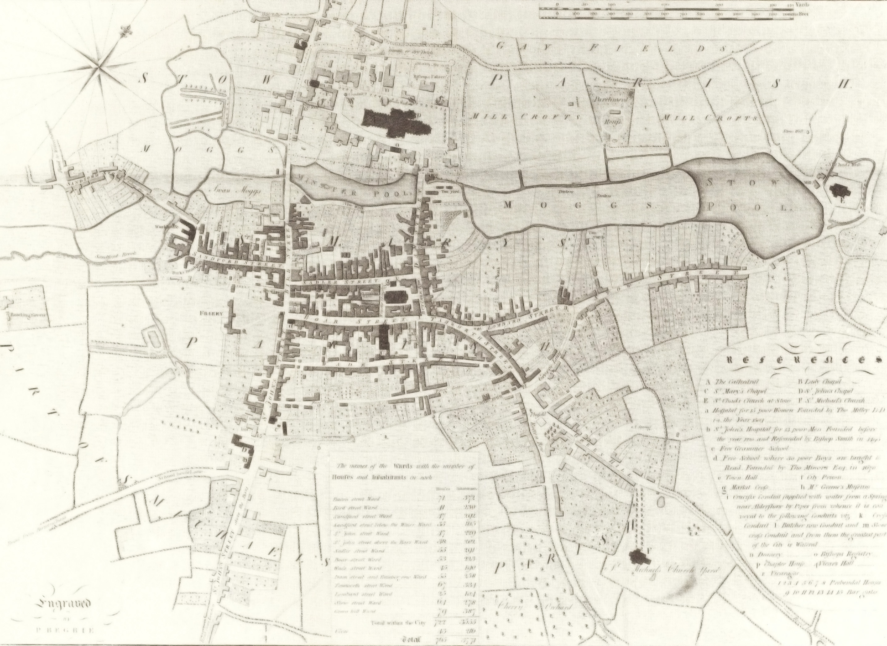
 Map of Lichfield in 1781
Lichfield started to develop a lively coaching trade as a stop-off on the busy route between London and Chester from the 1650s onwards, making it Staffordshire's most prosperous town. In the 18th century and reaching its peak in the period from 1800—1840, the city thrived as a busy coaching city on the main routes from London to the north-west and Birmingham to the north-east. It also became a centre of great intellectual activity being the home of many famous people including Samuel Johnson, David Garrick, Erasmus Darwin and Anna Seward; this prompted Johnson's remark that Lichfield was "a city of philosophers". In the 1720s Daniel Defoe described Lichfield as 'a fine, neat, well-built, and indifferent large city', the principal town in the region after Chester.[12] During the late 18th and early 19th century much of the medieval city was rebuilt with the red brick Georgian style buildings we see today. Also during this time the city underwent vast improvements with underground sewerage systems, paved streets and gas powered street lighting.[13] An infantry regiment of the British Army was formed at Lichfield in 1705 by Col. Luke Lillingstone in the King's Head pub in Bird Street. In 1751 it became the 38th regiment of foot and in 1783 the 1st Staffordshire Regiment; after reorganization in 1881 it became the 1st battalion of the South Staffordshire Regiment.[12]
Late Modern and contemporary
The arrival of the Industrial Revolution and the railways in 1837 signalled the end of Lichfield's position as an important staging post for coaching traffic. Whilst the industrial development at nearby Birmingham exploded, along with its population, Lichfield remained largely unchanged in character.
The first council houses were built in the Dimbles area of the city in the 1930s. The outbreak of World War II brought over 2000 evacuees from industrialised areas. However due to the lack of heavy industry in the city, Lichfield escaped lightly, although there were air raids in 1940 and 1941 and 3 Lichfeldians were killed. Just outside the city Wellington Bombers flew out of Fradley Aerodrome which was known as RAF Lichfield. After the war the council built many new houses in the 1960s including some high-rise flats, the late 70s and early 80s brought a large housing estate at Boley Park in the east of the city. The city's population tripled between 1951 and the late 1980s.
The city has continued expanding to the west, the Darwin Park housing estate has been under development for a number of years and has swelled the city's population by approximately 3,000. Plans have been approved for Friarsgate, a new £100 million shopping and leisure complex opposite Lichfield City Station. The police station, bus station, Ford garage and multi-storey car park will be demolished to make way for 22,000m2 of retail space and 2,000m2 of leisure facilities consisting of a flagship department store, six-screen cinema, hotel, 37 individual shops and 56 apartments.[14] In July 2009, The Staffordshire Hoard, the largest collection of Anglo-Saxon gold ever found, was discovered in a field in the parish of Hammerwich, 4 miles (6.4 km) south west of Lichfield.
Governance
Local government
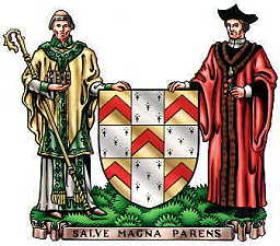
 The motto on Lichfield's coat of arms quotes Samuel Johnson's tribute to his native city in his Dictionary, "Salve, magna parens" ("Hail great parent").
Historically the Bishop of Lichfield had authority over the city. It was not until 1548 with Edward VI's charter that Lichfield had anything like a secular government. As a reward for the support given to Mary I by the bailiffs and citizens during the duke of Northumberland's attempt to prevent her accession, the queen issued a new charter in 1553, confirming the 1548 charter and in addition granting the city its own sheriff. The same charter made Lichfield a county separate from the rest of Staffordshire. It remained so until 1888.
The City Council has 28 members from the 6 wards of Boley Park, Chadsmead, Curborough, Leamonsley, St Johns and Stowe, who are elected every four years. After the 2011 parish council elections, the Conservatives remained in overall control, with 28 seats being divided between the Conservatives (26), Labour, (1), Liberal Democrat (1). The Mayor, Brian Bacon is the civic head of the Council and chairs Council meetings. The Council also appoints a Leader of Council to be the main person responsible for leadership of the Council's political and policy matters. The Council is also one of only 15 towns and cities in England and Wales which appoints a Sheriff.[15]
Members of Parliament
The Lichfield constituency sent two members to the parliament of 1304 and to a few succeeding parliaments, but the representation did not become regular until 1552; in 1867 it lost one member, and in 1885 its representation was merged into that of the county.[12] The Lichfield constituency was abolished in 1950 and replaced with the Lichfield and Tamworth constituency. This contituency lasted until 1983 when it was replaced with the Mid Staffordshire constituency.
The current Member of Parliament for Lichfield is the Conservative Michael Fabricant, who has been MP for Lichfield since 1997. Fabricant was first elected for the Mid Staffordshire constituency in 1992 regaining the seat for the Conservatives following Sylvia Heal's victory for Labour at the 1990 by-election. Fabricant took the seat with a majority of 6,236 and has remained a Member of Parliament since. The Mid Staffordshire seat was abolished at the 1997 general election, but Fabricant contested and won the Lichfield constituency, which partially replaced it, by just 238 votes. He has remained the Lichfield MP since, increasing his majority to 4,426 in 2001, 7,080 in 2005 and 17,683 in 2010.
Geography
Lichfield covers an area of approximately 3.8 sq mi (9.8 km2) in the south east of the county of Staffordshire in the West Midlands region of England. It is approximately 25 km (16 mi) north of Birmingham and 200 km (120 mi) north west of London. The city is located between the high ground of Cannock Chase on the west and the valleys of the Rivers Trent and Tame on the east. It is underlain by red sandstone, deposited during the arid desert conditions of the Triassic period. Mercia Mudstone underlies the north and north eastern edges of the city towards Elmhurst and Curborough. The red sandstone underlying the majority of Lichfield is present in many of its ancient buildings including Lichfield Cathedral and the Church of St Chad.[16]
The ground within the city slopes down from 116m in the north west to 86m on the sandstone shelf where Lichfield Cathedral stands. To the south and east of the city centre is a ridge which reaches 103m at St Michael on Greenhill. Boley Park lies on top of a ridge with its highest point on Borrowcop Hill at 113m. To the south east the level drops to 69m where Tamworth Road crosses the city boundary into Freeford. There is another high ridge south west of the city where there are two high points one at Berry Hill Farm at 123m and the other on Harehurst Hill near the city boundary at Aldershawe where the level reaches 134m.[17]
The city is built on the two sides of a shallow valley, into which flows two streams from the west, the Trunkfield Brook and the Leamonsley Brook and out of which the Curborough Brook runs to the north east, eventually flowing into the River Trent. The two streams have been dammed south of the Cathedral on Dam Street to form Minster Pool and near St Chads Road to form Stowe Pool.
 Panorama of the city, taken from Lichfield Cathedral central spire
 Panorama from Harehurst Hill 1.5 miles south west of the cathedral, showing Lichfield's distinctive 5 spires
Suburbs
Boley Park | Chadsmead | Christ Church | Darwin Park | The Dimbles | Leamonsley | Nether Stowe | Sandfields | Stowe
Nearby places
Major towns and cities are in upper case, not all nearby villages and hamlets are listed here:

Longdon, Armitage, Mavesyn Ridware, RUGELEY, STAFFORD Elmhurst, Curborough, Kings Bromley, Abbots Bromley, Uttoxeter, Ashbourne Streethay, Fradley, Alrewas, Croxall, Edingale, BURTON UPON TRENT, DERBY Hammerwich, Gentleshaw, Cannock Wood, Burntwood, Chasetown, CANNOCK 
Whittington, Fisherwick, Elford, Thorpe Constantine, Appleby Magna, Measham  Lichfield

Brownhills, Walsall Wood, Bloxwich, WALSALL, WOLVERHAMPTON Wall, Shenstone, Sutton Coldfield, BIRMINGHAM, Solihull Swinfen & Packington, Weeford, Hopwas, Hints, TAMWORTH, COVENTRY Demographics
At the time of the 2001 census, the population of the City of Lichfield was 27,900. Lichfield is 98.1% white and 79% Christian. 56.7% of the population over 16 were married. 63.2% were employed and 16% of the people were retired. All of these figures were higher than the national average.[18]
Population growth of the City of Lichfield since 1685 Year 1685 1781 1801 1831 1901 1911 1921 1931 1951 1961 1971 1981 1991 2001 Population 3,040 3,555 4,840 6,252 7,900 8,616 8,393 8,507 10,260 14,090 22,660 25,400 28,666 27,900 %± - 16.9% 36.1% 29.2% 26.4% 9.1% -2.6% 1.35% 19.1% 37.3% 60.8% 12.1% 12.9% -2.7% Economy
 The Tudor Café in Bore Street was built in 1510
Lichfield's wealth grew along with its importance as an ecclesiastical centre. The original settlement prospered as the place where pilgrims gathered to worship at the shrine of St Chad, this practice continued up until the Reformation when the shrine was destroyed.
In the Middle Ages, the main industry in Lichfield was making woollen cloth. There was also a leather industry in Lichfield. Much of the surrounding area was open pasture and there were many surrounding farms.
In the 18th century, Lichfield became a busy coaching centre. Inns and hostelries grew up to provide accommodation and industries dependant on the coaching trade such as coach builders, corn and hay merchants, saddlers and tanneries began to thrive. The main source of wealth to the city came from the money generated by its many visitors. The invention of the railways saw the decline in coach travel and with it came the decline in Lichfield's prosperity.
By the end of the 19th century, brewing was the principal industry, and in the neighbourhood were large market gardens which provided food for the growing populations of nearby Birmingham and the Black Country.
Today there are a number of light industrial areas predominantly in the east of the city, not dominated by any one particular industry. The district is famous for two local products: Armitage Shanks, manufacturers of baths/bidets and showers, and Arthur Price of England, master cutlers and silversmiths. Many residents commute to Birmingham.
Lichfield City Council has predicted that once completed, the new Friarsgate retail and leisure development could attract 11,000 more visitors to the city every month, generating annual sales of around £61 million and creating hundreds of jobs in the city.[19]
Culture and Community
 Lichfield Garrick Theatre was built in 2003
Culture
The Lichfield Greenhill Bower, a festival dating back to the Middle Ages takes place annually on Spring Bank Holiday. Originating from a celebration that took place after the Court of Arraye in the 12th century, the festival has evolved into what it is today but has kept many of its ancient traditions.[20] After a recreation of the Court of Arraye at the Guildhall, a procession of marching bands, morris men and carnival floats makes its way through the city, where the Bower Queen is crowned outside the Guildhall. There is a fun fair in the city centre, and another fair and jamboree in Beacon Park.[20]
The Lichfield Festival, an arts festival has taken place every July for 30 years. The festival is a celebration of classical music, dance, drama, film, jazz, literature, poetry, visual arts and world music. Events take place at many venues around the city but centre on Lichfield Cathedral and the Garrick Theatre. Popular events include the medieval market in the Cathedral Close and the fireworks display which closes the festival.[21]
Triennially the Lichfield Mysteries, the biggest community theatre event in the country takes place at the Cathedral and the Market Place. It consists of a cycle of 24 medieval style plays involving over 600 amateur actors.[22] Other weekend summer festivals include the Lichfield Folk Festival[23] and The Lichfield Real Ale, Jazz and Blues Festival.[24]
Dr Johnson’s Birthday Celebrations and Lichfield Heritage Weekend takes place on the third weekend in September with a variety of civic events including live music and free historical tours of local landmarks.
Community Facilities
 Beacon Park, in the city centre, hosts a wide range of community events.
There are many parks, gardens and open spaces in the city. The city centre park is Beacon Park which hosts a range of community events and activities throughout the year. Also in the city centre are two lakes, Minster Pool and Stowe Pool. The Garden of Remembrance, a memorial gardens laid out in 1920 after World War I is located on Bird Street. Many other parks are located on the outskirts of the city, these include Brownsfield Park, Darnford Park, Shortbutts Park, Stychbrook Park, Saddlers Wood and Christian Fields.[25]
There are two public sports leisure facilities in the city. Friary Grange Leisure Centre in the north west of the city offers raquet sports, a swimming pool and sports hall and fitness gym. King Edward VI Leisure Centre in the south of the city offers raquet sports, a sports hall and an artificial turf pitch.
Lichfield Library and Record Office is located on the corner of St John Street and The Friary. The building also provides adult education centre and a small art gallery. The current building became the library in 1989 after it moved from Lichfield Free Library and Museum on Bird Street.
The city is served by the Samuel Johnson Community Hospital located on Trent Valley Road. This hospital replaced the now demolished Victoria Hospital in 2006.
Places of Interest
 The Hospital of St John Baptist without the Barrs built in 1495 as an almshouse.
 The entrance to Cathedral Close at night, with Lichfield Cathedral in the background
 Lichfield Cathedral - The only medieval cathedral in Europe with three spires. The present building was started in 1195, and completed by the building of the Lady Chapel in the 1330s. It replaced a Norman building begun in 1085 which had replaced one, or possibly two, Saxon buildings from the seventh century.
- Cathedral Close - Surrounding the Cathedral with its many fine buildings is one of the most unspoilt in the country.
 Samuel Johnson Birthplace Museum - A museum to Samuel Johnson's life, work and personality.
- Erasmus Darwin House - Home to Erasmus Darwin, the house was restored to create a museum which opened to the public in 1999.
- Lichfield Heritage Centre - in St Mary's Church in the market square, an exhibition of 2,000 years of Lichfield's history.
 Bishop's Palace - Built in 1687, the palace was the residence of the Bishop of Lichfield until 1954; it is now used by the Cathedral School.
- Milley's Hospital - Located on Beacon Street, it dates back to 1504 and was a women's hospital.
- Hospital of St John Baptist without the Barrs - A distinctive Tudor building with a row of eight brick chimneys. This was built outside the city walls (barrs) to provide accommodation for travellers arriving after the city gates were closed. It now provides home for elderly people and has an adjacent Chapel.
- Church of St Chad - A 12th century church though extensively restored, on its site is a Holy Well by which St Chad is said to have prayed and used the waters' healing properties.
- St Michael on Greenhill - Overlooking the city the ancient churchyard is unique as one of the largest in the country at 9 acres (4 ha).
- Christ Church - An outstanding example of Victorian ecclesiastical architecture and a grade II* listed building.
- The Market Square - In the centre of the city the square contains two statues, one of Samuel Johnson overlooking the house in which he was born, and one of his great friend and biographer, James Boswell.
- Beacon Park - An 81-acre (33 ha) public park in the centre of the city, used for many sporting and recreational activities.
- Minster Pool & Stowe Pool - The two lakes occupying 16 acres in the heart of Lichfield, Stowe Pool is designated a SSSI site as is it home to native White-Clawed Crayfish.
- The Franciscan Friary - The ruins of the former Friary in Lichfield, now classed as a Scheduled Ancient Monument.
- Lichfield Clock Tower - A Grade II listed 19th century clock tower, located south of Festival Gardens.

 Letocetum - The remains of a Roman Staging Post and Bath House, in the village of Wall, 3.5 km (2.2 mi) south of the city.
- Staffordshire Regiment Museum - 2.5 miles (4 km) east of the city in Whittington, the museum covers the regiment's history, activities and members, and include photographs, uniforms, weapons, medals, artifacts, memorabilia and regimental regalia. Outdoors is a replica trench from World War I, and several armoured fighting vehicles.
- National Memorial Arboretum - 4 miles (6 km) north east of the city in Alrewas, the arboretum is a national site of remembrance and contains many memorials to the armed services.
 Cannock Chase - A designated Area of Outstanding Natural Beauty, is 5 miles (8 km) north west of the city. It comprises a mixture of natural deciduous woodland, coniferous plantations and open heathland. There are a number of visitor centres, museums and waymarked paths, including the Heart of England Way and the Staffordshire Way.
- Shugborough Hall - On Cannock Chase's north-eastern edge, the ancestral home of the Earls of Lichfield.
Transport
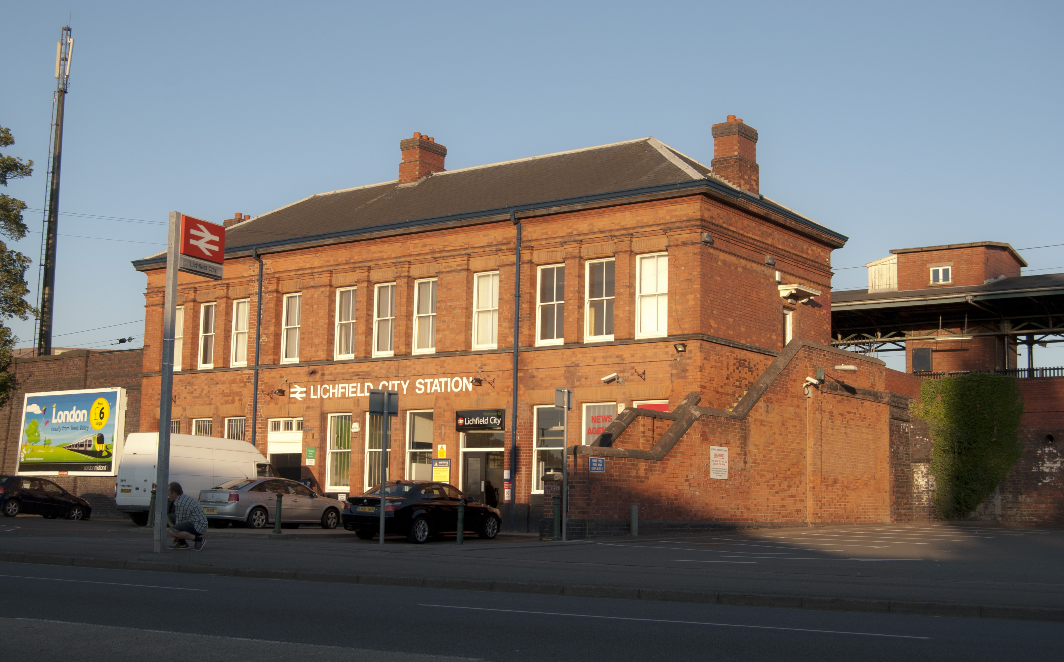
 Lichfield City station is one of the two railway stations in Lichfield
 The first section of Lichfield Canal to be re-watered on Tamworth Road
Lichfield is served by two railway stations, Lichfield City and Lichfield Trent Valley, both built by the London and North Western Railway. These stations are now on the Cross-City Line to Redditch via Birmingham. Additionally, Trent Valley station is on the West Coast Main Line with hourly direct semi-fast services to London Euston, and also to Stafford, Stoke and Crewe, supplemented by occasional fast services. Despite being north of Birmingham, trains between Lichfield Trent Valley and London Euston can take as little as 1 hour 9 minutes. Lichfield City is located in the city centre and Lichfield Trent Valley is located 1.37 km (0.85 mi) or 20 minutes walk north east of the city centre.
Lichfield has regular bus services in and around the city. The bus station is located on Birmingham Road opposite Lichfield City railway station although as part of the Friarsgate development plans have been approved for it to be re-located next to the railway station. Arriva Midlands as well as some other operators do regular services to Birmingham, Burntwood, Burton upon Trent, Nuneaton, Stafford, Staffordshire University, Sutton Coldfield, Stoke on Trent, Tamworth, Uttoxeter, and Walsall.
Lichfield is centrally located on the UK road network. Historically the Roman roads of Watling Street and Ryknild Street crossed 3.2 km (2.0 mi) south of the city at Letocetum. Today following much of the same routes are the A5 and A38. The A5 runs west towards Wales and south east towards Tamworth. The A38 runs south to Birmingham and north east to Derby. Running along the western perimeter of the city is the A51 road, which runs north to Chester and south west to Tamworth. The nearest motorway junction is Junction T5 of the M6 Toll, located 3.2 km (2.0 mi) south of the city. Junction 9 of the M42 and Junction 4A of the M6 are 19 km (12 mi) and 24 km (15 mi) south respectively.
Lichfield Canal was historically part of the Wyrley and Essington Canal and ran south of the city from 1797 until it was abandoned in 1955. Starting in the 1990's a works programme started to restore the canal along much of its original route and make it navigable by 2025. As of 2011, none of the 11.3 km (7.0 mi) stretch of canal is navigable. The nearest navigable canal to Lichfield is the Coventry Canal which runs through Streethay.
Two nearby airports serve Lichfield. Birmingham Airport is 32 km (20 mi) south and East Midlands Airport is 55 km (34 mi) north east.
Education
 The main entrance to the Lichfield Campus of Staffordshire University
In addition to nine Primary schools and 1 Infant school, Lichfield has three secondary schools:
- The Friary School
- King Edward VI School (formerly Lichfield Grammar School)
- Nether Stowe High School, a comprehensive school with specialist Maths and Computing college status
There are two independent schools:
- Lichfield Cathedral School — A co-educational school for ages 3 to 18, based in the Cathedral Close and Longdon.
- Maple Hayes School — A DfES Approved Special School for dyslexic children.
The Lichfield campus of Staffordshire University and South Staffordshire College is located on The Friary. This campus facility was opened in 1998 and offers further and higher education courses up to and including masters degrees. A £3 million School of Art, Design and Media, housed in purpose-built accommodation opened in 2006. This facility received the highest possible grade of 'outstanding provision' in the latest Ofsted inspection report.
Religion and beliefs
 St Michael on Greenhill, one of the three medieval parish churches in Lichfield
The largest religious denomination in Lichfield parish is Christianity; 78.7% of the people in the area polled as part of the 2001 Census professed the Christian faith. Lichfield has held a religious importance since St Chad became the first Bishop of Lichfield and built a monastery in 669 CE. After Chads death in 672 CE he was buried in a Anglo-Saxon church which later became part of Lichfield Cathedral.
The Anglican faith is in the majority with three parishes as well as the Cathedral. St Michael’s and St Mary’s serve one parish and Christ Church and St Chad's serve the other two. Lichfield is within the Diocese of Lichfield and represented by Jonathan Gledhill, the 98th Bishop of Lichfield.
There are two Roman Catholic churches; the Holy Cross and SS. Peter & Paul which are part of the Archdiocese of Birmingham. In the city centre there is a Methodist church and Wade Street Church, which is a United Reformed and Baptist church. There is a Pentecostal Church under the name Emmanuel Christian Centre in Nether Stowe and the Christadelphian Hall on Station Road. The Jehovah's Witnesses have a Kingdom Hall on Lombard Street.
There are five faith schools in the city all of which are primary schools. St Michael’s C of E School, Christ Church C of E School and St Chad’s C of E (VC) School are all Church of England faith schools. St Joseph's RC School and SS. Peter & Paul School are Roman Catholic faith schools.
There are no places of worship in Lichfield for any other major world religions.
Humanists and atheists in Lichfield are supported by the Lichfield, Walsall & South Staffordshire Humanists (LWASS), affiliated to the British Humanist Association.
Sport
Historically rugby was more popular in the city than football, this was largely due to the fact that it was the main sport at Lichfield Grammar School. However, both sports have remained at amateur level. Lichfield Rugby Union Football Club was founded in 1874. As of 2010–11 season they play in the Midlands 1 West League; which is the 6th level of the English Rugby Union system. The team plays at Cooke Fields located south east of the city on Tamworth Road, behind the Horse and Jockey public house.
AFC Lichfield is a community youth football club. The club currently have teams playing in the Lichfield & District Recreational League at under 7's, under 12's and under 15's. The club play there home matches at Beacon Park and the A51 Bypass. AFC Lichfield also boast a football academy offering FA coaching to boys and girls aged 4-8 years.
Lichfield City Football Club (formerly known as Beacon Park F.C. until June 2006) played in the Burton & District League until 2008. Following a successful season where goals from Adam Eccles and Simon Deeley saw the side win the Memorial cup. On the back of this success the club gained entrance to the Midland Football Combination. Lichfield gained promotion from the third division in their first full season and narrowly missed out on back to back promotions in the 2009–2010 season. In the 2011–12 season Lichfield will play in the first division after promotion in 2011. The 1st team play at Brownsfield Park next the new Lichfield City FC Social Club (formerly known as Enots). LCFC are a FA Charter Community club with teams from under 7's to Adults.
Lichfield Diamonds LFC is at the forefront of girls football in Staffordshire, being the first all female club to achieve Charter Standard Status. The team plays at the Collins Hill Sports Ground.
Lichfield Cricket Club, currently playing in the Third Division of the Birmingham and District Premier League. They also play at the Collins Hill Sports Ground.
Lichfield is served by four golf courses, these include the local authority 18 hole course at Beacon Park. Darnford Moors Golf Club; a new facility in the south of the city which provides a 9 hole pay and play facility, a driving range and coaching academy. Lichfield Country Club; based in Elmhurst, the club boasts a 18 hole par 72 championship course and the Midlands first American specification 9 hole par 3 course. Whittington Heath Golf Club; an 18 hole par 70 course south east of the city, laid out on heathland and woodland.
Lichfield Archers were formed over 40 years ago and shoot at Christian Fields, where they have 20 yard indoor and 100 yard outdoor ranges.
Notable Lichfeldians
 Statue of Dr. Johnson in Lichfield's Market Square
 Photograph by Richard Cockle Lucas (sculptor) of Johnson statue taken in 1859
- Joseph Addison (1672–1719) — Politician and writer
- Richard Allinson (born 1958) — Broadcaster, currently presenting the early morning weekend show on BBC Radio 2
- Elias Ashmole (1617–1692) — Antiquarian, politician, founder of Ashmolean Museum and advisor to Charles II
- Helen Baxendale (born 1970) — Actress
- Sian Brooke (born 1980) — Actress
- Adam Christodoulou (born 1989) — Racing driver, 2008 British Formula Renault Champion, 2009 Star Mazda Champion.
- Erasmus Darwin (1731–1802) — Scientist, inventor and literary man and grandfather of Charles Darwin
- Thomas Day (1748–1789) — Author and abolitionist, lived for a time at Stowe House
- Siobhan Dillon (born 1984) — Singer and actress
- Richard Lovell Edgeworth (1744–1817) — Politician, writer and inventor, lived for a time at Stowe House
- Richie Edwards (born 1974) — Bassist with rock bands The Darkness and Stone Gods
- John Floyer (1649–1734) — English physician and author of the 18th century
- Phil Ford — Television Writer
- Bryn Fowler (born 1982) — Musician, Bassist and backing vocalist in the band The Holloways
- Richard Garnett (1835–1906) — Scholar, librarian, biographer and poet
- David Garrick (1717–1779) — Famous 18th century actor, playwright, producer and theatre manager
- Saint Edmund Jennings (1567–1591) — Jesuit priest and martyr
- Samuel Johnson (1709–1784) — 18th century poet, essayist, lexicographer and writer of the first Dictionary of the English Language
- David Charles Manners (born 1965) — Theatre designer, author and charity founder
- Gary Mason (born 1979) — Motorcycle racer in the British Superbike Championship
- Robert Rock (born 1977) — Professional Golfer currently on the PGA European Tour, formerly a coach at Swingers Golf Centre
- Anna Seward (1747–1809) — Romantic poet, memorialist and letter writer
Twinnings
The City of Lichfield is twinned with:
 Limburg an der Lahn, Germany
 Sainte-Foy-lès-Lyon, France.
See also
- Bishops of Lichfield
- The Lichfield Gospels
- Earl of Lichfield
- Lichfield Cricket Club
- Lichfield Canal
- Garrick Theatre
- Heart of England Way
- Lichfield Bower
- Lichfield Rugby Union Football Club
- RAF Lichfield
References
- ^ "Names and codes for Administrative Geography". Office for National Statistics. 31 December 2008. http://www.ons.gov.uk/about-statistics/geography/products/geog-products-area/names-codes/administrative/index.html. Retrieved 15 September 2009.
- ^ "Lichfield City Council - Statistics". 18 June 2011. http://www.lichfield.gov.uk/cc-statistics.ihtml.
- ^ "Explaining the origin of the 'field of the dead' legend". British History Online. http://www.british-history.ac.uk/report.aspx?compid=42340. Retrieved 20 November 2008.
- ^ "English Place Name Society Database at Nottingham University". Nottingham.ac.uk. http://www.nottingham.ac.uk/~cczappdv/epnnewmap/detailpop.php?placeno=9823. Retrieved 2010-07-17.
- ^ [From: 'Lichfield: The place and street names, population and boundaries ', A History of the County of Stafford: Volume 14: Lichfield (1990), pp. 37-42. URL: http://www.british-history.ac.uk/report.aspx?compid=42340 Date accessed: 20 July 2009.]
- ^ a b c Greenslade, M.W. (1990), A History of the County of Stafford: Volume XIV: Lichfield, Victoria County History, ISBN 978-0197227787
- ^ a b From: 'Lichfield: History to c.1500', A History of the County of Stafford: Volume 14: Lichfield (1990), pp. 4-14. URL: http://www.british-history.ac.uk/report.aspx?compid=42336 Date accessed: 24 July 2009.
- ^ "Brief History of Lichfield". Local Histories. http://www.localhistories.org/lichfield.html. Retrieved 20 November 2008.
- ^ "'Lichfield: From the Reformation to c.1800', A History of the County of Stafford: Volume 14: Lichfield (1990), pp. 14-24.". British History Online. http://www.british-history.ac.uk/report.aspx?compid=42337. Retrieved 22 November 2008.
- ^ Wikisource: Dictionary of National Biography
- ^ Cobbett's complete collection of state trials and proceedings, 735–736.
- ^ a b c From: 'Lichfield: From the Reformation to c.1800', A History of the County of Stafford: Volume 14: Lichfield (1990), pp. 14-24. URL: http://www.british-history.ac.uk/report.aspx?compid=42337 Date accessed: 24 July 2009.
- ^ Clayton, Howard (1981), Coaching City, Abottsford Publishing, ISBN 978-0950356310
- ^ Lichfield District Council:Friarsgate Plans, http://www.lichfielddc.gov.uk/site/scripts/documents_info.php?documentID=1328, retrieved 26 January 2011
- ^ "Lichfield City Council Functions". Lichfield.gov.uk. http://www.lichfield.gov.uk/cc.ihtml. Retrieved 2010-07-17.
- ^ British Geological Survey:Geology of Britain viewer, http://maps.bgs.ac.uk/geologyviewer_google/googleviewer.html, retrieved 20 January 2011
- ^ Ordnance Survey Map:Lichfield, http://www.bing.com/maps/?FORM=MUKMMP&PUBL=Google&mkt=en-GB&crea=userid2508go2d31d19252d0b114ed487e8ed62ff0c8#JnE9LndzMTQrOWVqJTdlc3N0LjAlN2VwZy4xJmJiPTU2LjY0NzIyMTE5MTgxODYlN2UxMC4xNzMzMzk4NDM3NSU3ZTQ1LjcyNTQyNDg5MzQ3NzYlN2UtMTAuMTczMzM5ODQzNzU=, retrieved 20 January 2011
- ^ "Statistics". Lichfield. http://www.lichfield.gov.uk/cc-statistics.ihtml. Retrieved 2010-07-17.
- ^ "Economic benefits of new development to Lichfield". icLichfield. http://iclichfield.icnetwork.co.uk/news/localnews//tm_headline=credit-squeeze-delays-friarsgate&method=full&objectid=22250839&siteid=108911-name_page.html. Retrieved 20 November 2008.
- ^ a b Lichfield Bower: The Bower & Its Origins, http://www.lichfieldbower.co.uk/the-bower-and-it-s-origins/, retrieved 28 January 2011
- ^ Lichfield Festival: About Us, http://www.lichfieldfestival.org/about-us/, retrieved 28 January 2011
- ^ Lichfield Mysteries: Home Page, http://www.lichfieldmysteries.co.uk/, retrieved 28 January 2011
- ^ Lichfield Folk Festival, http://www.lichfieldfolkfestival.co.uk/minisite/minisite_home.aspx, retrieved 28 January 2011
- ^ Lichfield Arts: What's Onl, http://www.lichfieldarts.org.uk/rajb.asp, retrieved 28 January 2011
- ^ Lichfield District Council: Lichfield's Parks, http://www.lichfielddc.gov.uk/site/scripts/documents.php?categoryID=200145, retrieved 28 January 2011
External links
- Lichfield City Council
- Lichfield District Council
- Visit Lichfield - Travel and Tourism body
- Lichfield Arts
 "Lichfield". New International Encyclopedia. 1905.
- "Lichfield". Encyclopedia Americana. 1920.
- http://www.lichfieldpeople.co.uk
Lichfield District Council Lichfield District CouncilCivil parishes Alrewas • Armitage with Handsacre • Burntwood • Clifton Campville • Colton • Curborough and Elmhurst • Drayton Bassett • Edingale • Elford • Farewell and Chorley • Fazeley • Fisherwick • Fradley • Hammerwich • Hamstall Ridware • Harlaston • Hints • Kings Bromley • Lichfield • Longdon • Mavesyn Ridware • Shenstone • Streethay • Swinfen and Packington • Thorpe Constantine • Wall • Weeford • Whittington • Wigginton and HopwasCeremonial county of Staffordshire Unitary authorities Boroughs or districts Major settlements Biddulph • Burntwood • Burton upon Trent • Cannock • Cheadle • Eccleshall • Fazeley • Hednesford • Kidsgrove • Leek • Lichfield • Newcastle-under-Lyme • Penkridge • Rugeley • Stafford • Stoke-on-Trent (Burslem • Fenton • Hanley • Longton • Stoke • Tunstall) • Stone • Tamworth • Uttoxeter • Wombourne
See also: List of civil parishes in StaffordshireRivers Canals Topics MuseumsCities of the United Kingdom England Bath · Birmingham · Bradford · Brighton and Hove · Bristol · Cambridge · Canterbury · Carlisle · Chester · Chichester · Coventry · Derby · Durham · Ely · Exeter · Gloucester · Hereford · Kingston upon Hull · Lancaster · Leeds · Leicester · Lichfield · Lincoln · Liverpool · London · Manchester · Newcastle upon Tyne · Norwich · Nottingham · Oxford · Peterborough · Plymouth · Portsmouth · Preston · Ripon · St Albans · Salford · Salisbury · Sheffield · Southampton · Stoke-on-Trent · Sunderland · Truro · Wakefield · Wells · Westminster · Winchester · Wolverhampton · Worcester · York
Scotland Wales Northern Ireland Categories:- Lichfield
- Cities in the West Midlands (region)
- Civil parishes in Staffordshire
- Towns in Staffordshire


Wikimedia Foundation. 2010.