- Crookham, Berkshire
-
Coordinates: 51°22′34″N 1°13′52″W / 51.375997°N 1.231041°W
Crookham 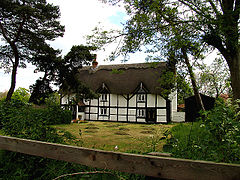
"Old Thatch"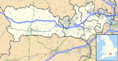
 Crookham
Crookham shown within BerkshireOS grid reference SU536641 Metropolitan borough West Berkshire Metropolitan county Berkshire Region South East Country England Sovereign state United Kingdom Post town Thatcham Postcode district RG19 Dialling code 0118 Police Thames Valley Fire Royal Berkshire Ambulance South Central EU Parliament South East England UK Parliament Berkshire List of places: UK • England • Berkshire Crookham is a village in the English county of Berkshire, and part of the civil parish of Greenham.
The settlement lies near to the A339 and A4 roads, and is located approximately 4 miles (6.4 km) south-east of Thatcham. Crookham - like the adjoining Crookham Common - is situated at the end of the runway of RAF Greenham Common.
History
The village was originally owned by Reading Abbey, and thus King Henry III of England visited the hamlet in 1229 - most probably to engage in hunting in the rural areas[1].
References
External links
 Media related to Crookham, Berkshire at Wikimedia CommonsCategories:
- Berkshire geography stubs
- Villages in Berkshire
- West Berkshire


Wikimedia Foundation. 2010.