- National Register of Historic Places listings in Columbia County, Wisconsin
-
Buildings, sites, structures, districts, and objects in Columbia County listed on the National Register of Historic Places
 Gov. James T. Lewis House
This document is intended to provide a comprehensive listing of entries in the National Register of Historic Places that are located in Columbia County, Wisconsin. The locations of National Register properties, the latitude and longitude coordinates of which are included below, may be seen in a Google map.[1]
-
- This National Park Service list is complete through NPS recent listings posted November 10, 2011.[2]
Current listings
[3] Landmark name Image Date listed Location City or town Summary 1 E. Clarke and Julia Arnold House 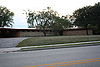
April 12, 2007 954 Dix St.
43°20′11″N 89°01′46″W / 43.336389°N 89.029444°WColumbus Frank Lloyd Wright-designed house 2 Clara F. Bacon House January 14, 2009 509 Madison Ave.
43°18′37″N 89°31′28″W / 43.310236°N 89.524533°WLodi 3 Albert M. and Alice Bellack House 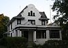
June 7, 2010 628 W. James St.
43°20′31″N 89°01′13″W / 43.342°N 89.020153°WColumbus 4 Bellmont Hotel November 4, 1993 120 N. Main St.
43°32′13″N 89°18′00″W / 43.536944°N 89.3°WPardeeville 5 H. H. Bennett Studio October 8, 1976 215 Broadway
43°37′41″N 89°46′28″W / 43.628056°N 89.774444°WWisconsin Dells 6 Bowman House April 3, 1986 714 Broadway St.
43°37′38″N 89°46′02″W / 43.627222°N 89.767222°WWisconsin Dells 7 Daniel and Nellie Byrns House October 16, 2008 221 Mill St.
43°18′40″N 89°31′49″W / 43.311231°N 89.530161°WLodi 8 F. A. Chadbourn House 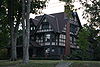
December 28, 1990 314 S. Charles St.
43°20′28″N 89°01′24″W / 43.341111°N 89.023333°WColumbus 9 Church Hill Historic District January 25, 1997 Roughly bounded by Adams, Pleasant, Lock, and Franklin Sts.
43°32′32″N 89°27′43″W / 43.542222°N 89.461944°WPortage 10 Columbus City Hall 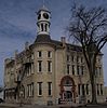
September 4, 1979 105 N. Dickason St.
43°20′15″N 89°00′56″W / 43.3375°N 89.015556°WColumbus 11 Columbus Downtown Historic District 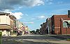
March 5, 1992 Roughly bounded by Mill, Water and Harrison Sts. and Dickason Blvd.
43°20′19″N 89°00′54″W / 43.338611°N 89.015°WColumbus 12 Columbus Fireman's Park Complex 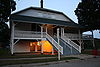
February 25, 2004 1049 Park Ave.
43°19′48″N 89°01′24″W / 43.33°N 89.023333°WColumbus 13 Columbus Post Office 
October 24, 2000 211 S. Dickason Blvd.
43°20′16″N 89°00′59″W / 43.337778°N 89.016389°WColumbus 14 Columbus Public Library 
November 15, 1990 112 S. Dickason Blvd.
43°20′20″N 89°00′58″W / 43.338889°N 89.016111°WColumbus 15 Angie Williams Cox Library November 15, 1990 129 N. Main St.
43°32′14″N 89°18′01″W / 43.537222°N 89.300278°WPardeeville 16 Durward's Glen November 7, 1978 NE of Merrimac off WI 78
43°26′12″N 89°35′37″W / 43.436667°N 89.593611°WMerrimac 17 Farmers and Merchants Union Bank 
October 18, 1972 159 W. James St.
43°20′19″N 89°00′55″W / 43.338697°N 89.015239°WColumbus The last Louis Sullivan jewel bank 18 Fred and Lucia Farnham House 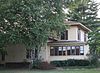
July 30, 2009 553 W. James St.
43°20′32″N 89°01′14″W / 43.342167°N 89.020519°WColumbus 19 Fort Winnebago Site May 17, 1979 Address Restricted Portage 20 Fort Winnebago Surgeon's Quarters October 28, 1970 0.1 mi. South of corporate city limits on WI 33
43°33′15″N 89°25′58″W / 43.554167°N 89.432778°WPortage 21 Fox-Wisconsin Portage Site March 14, 1973 Address Restricted Portage 22 Zona Gale House October 24, 1980 506 W. Edgewater St.
43°32′17″N 89°28′03″W / 43.538056°N 89.4675°WPortage 23 Goeres Park April 9, 2009 101 Fair St.
43°19′21″N 89°31′51″W / 43.322492°N 89.530714°WLodi 24 George Griswold House 
July 1, 2009 146 S. Dickason Blvd.
43°20′19″N 89°00′58″W / 43.338589°N 89.016047°WColumbus 25 Holsten Family Farmstead 
September 8, 1992 W1391 Weiner Rd.
43°17′24″N 89°04′06″W / 43.29°N 89.068333°WColumbus 26 Adolphus and Sarah Ingalsbe House 
July 1, 2009 546 Park Ave.
43°20′04″N 89°01′09″W / 43.334561°N 89.019275°WColumbus 27 John A. and Maggie Jones House 
July 30, 2009 307 N. Ludington St.
43°20′24″N 89°00′46″W / 43.339872°N 89.01265°WColumbus 28 Kilbourn Public Library December 27, 1974 429 Broadway
43°37′41″N 89°46′15″W / 43.628056°N 89.770833°WWisconsin Dells 29 Kingsley Bend Mound Group August 20, 1998 Address Restricted Wisconsin Dells Boundary increase (listed July 22, 2010): Address restricted, Town of Newport 30 John H. Kurth and Company Office Building 
December 2, 1993 729-733 Park Ave.
43°20′00″N 89°01′13″W / 43.333333°N 89.020278°WColumbus See: Kurth Brewery 31 Frank T. and Polly Lewis House January 14, 2009 509 N. Main St.
43°18′59″N 89°31′43″W / 43.316464°N 89.5286°WLodi 32 Gov. James T. Lewis House 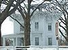
April 9, 1982 711 W. James St.
43°20′32″N 89°01′17″W / 43.342222°N 89.021389°WColumbus 33 Lodi School Hillside Improvement Site April 9, 2009 Corner Street, bounded by Pleasant Street and Columbus Street
43°18′40″N 89°31′30″W / 43.311111°N 89.525°WLodi 34 Lodi Street-Prairie Street Historic District June 22, 2000 Roughly Prairie St. from Second St. to Mill St.
43°18′48″N 89°31′42″W / 43.313333°N 89.528333°WLodi 35 Henry Merrell House 
July 8, 1993 505 E. Cook St.
43°32′34″N 89°27′13″W / 43.542778°N 89.453611°WPortage 36 Merrimac Ferry 
December 31, 1974 WI 113 at the Wisconsin River
43°22′05″N 89°37′26″W / 43.368056°N 89.623889°WMerrimac 37 Job Mills Block November 26, 2008 109-111 S. Main St.
43°18′44″N 89°31′31″W / 43.312136°N 89.525414°WLodi 38 Richard W. and Margaret Mills House February 18, 2009 104 Grand Ave.
43°18′45″N 89°31′56″W / 43.312453°N 89.532233°WLodi 39 Nashold 20-sided Barn February 11, 1988 Trunk Z, 0.4 mi. E of WI 146
43°25′44″N 89°05′15″W / 43.428889°N 89.0875°WFall River 40 Old Indian Agency House February 1, 1972 NE end of old Agency House Rd. (Rte.1) near NE city limits
43°33′33″N 89°26′14″W / 43.559167°N 89.437222°WPortage 41 Pardeeville Presbyterian Church January 15, 1980 105 S. Main St.
43°32′07″N 89°18′08″W / 43.535278°N 89.302222°WPardeeville 42 Portage Canal August 26, 1977 Between Fox and Wisconsin Rivers
43°32′49″N 89°26′50″W / 43.546944°N 89.447222°WPortage 43 Portage Industrial Waterfront Historic District March 17, 1995 Jct. of E. Mullet and Dodge Sts.
43°32′20″N 89°27′24″W / 43.538889°N 89.456667°WPortage 44 Portage Retail Historic District 
April 27, 1995 Roughly, Cook from Wisconsin to Main, Wisconsin from Cook to Edgewater and DeWitt from Conant to Edgewater
43°32′23″N 89°27′36″W / 43.539722°N 89.46°WPortage 45 Portage Street Historic District June 2, 2000 Roughly along Portage St. form Spring to Parr Sts.
43°18′53″N 89°31′29″W / 43.314722°N 89.524722°WLodi 46 Prairie Street Historic District 
January 7, 1999 Roughly along W. Prairie St., including parts of S. Lewis St. and S. Charles St.
43°20′23″N 89°01′22″W / 43.339722°N 89.022778°WColumbus 47 Joel M. Pruyn Block October 14, 2008 146 S. Main St.
43°18′45″N 89°31′32″W / 43.312425°N 89.525481°WLodi 48 John A. and Martha Robertson House January 22, 2009 456 Seminary St.
43°18′56″N 89°32′01″W / 43.315564°N 89.533578°WLodi 49 Reinhard and Amelia Schendel House 
June 7, 2010 211 North Ludington St.
43°20′21″N 89°00′49″W / 43.339167°N 89.013611°WColumbus 50 Frances Kurth Sharrow House 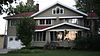
July 8, 2010 841 Park Ave.
43°19′57″N 89°01′19″W / 43.3325°N 89.021944°WColumbus 51 Society Hill Historic District March 5, 1992 Roughly bounded by W. Wisconsin, Cass and W. Emmett Sts. and MacFarlane Rd.
43°32′34″N 89°28′01″W / 43.542778°N 89.466944°WPortage 52 South Dickason Boulevard Residential Historic District 
March 4, 1999 Roughly along S. Dickason Blvd., from W. School St. to W. Harrison, also along S. Ludington St.
43°20′14″N 89°01′03″W / 43.337222°N 89.0175°WColumbus 53 Wawbeek-Horace A.J. Upham House June 19, 1985 WI 13
43°38′16″N 89°45′34″W / 43.637778°N 89.759444°WWisconsin Dells 54 Jacob Weber House January 20, 1978 825 Oak St.
43°37′44″N 89°46′27″W / 43.628889°N 89.774167°WWisconsin Dells 55 Zion Evangelical Lutheran Church and Parsonage 
July 8, 2009 236 and 254 W. Mill St.
43°20′24″N 89°00′55″W / 43.340044°N 89.015167°WColumbus References
- ^ The latitude and longitude information provided is primarily from the National Register Information System, and has been found to be fairly accurate for about 99% of listings. For 1%, the location info may be way off. We seek to correct the coordinate information wherever it is found to be erroneous. Please leave a note in the Discussion page for this article if you believe any specific location is incorrect.
- ^ "National Register of Historic Places: Weekly List Actions". National Park Service, United States Department of the Interior. Retrieved on November 10, 2011.
- ^ Numbers represent an ordering by significant words. Various colorings, defined here, differentiate National Historic Landmark sites and National Register of Historic Places Districts from other NRHP buildings, structures, sites or objects.
U.S. National Register of Historic Places Topics Lists by states Alabama • Alaska • Arizona • Arkansas • California • Colorado • Connecticut • Delaware • Florida • Georgia • Hawaii • Idaho • Illinois • Indiana • Iowa • Kansas • Kentucky • Louisiana • Maine • Maryland • Massachusetts • Michigan • Minnesota • Mississippi • Missouri • Montana • Nebraska • Nevada • New Hampshire • New Jersey • New Mexico • New York • North Carolina • North Dakota • Ohio • Oklahoma • Oregon • Pennsylvania • Rhode Island • South Carolina • South Dakota • Tennessee • Texas • Utah • Vermont • Virginia • Washington • West Virginia • Wisconsin • WyomingLists by territories Lists by associated states Other  Category:National Register of Historic Places •
  Portal:National Register of Historic PlacesCategories:
- Columbia County, Wisconsin
- Lists of historic places in Wisconsin
-


Wikimedia Foundation. 2010.