- Madurai district
-
This article is about the district. For its eponymous headquarters, see Madurai.
Madurai District
மதுரை மாவட்டம்
— district — Dawn in the city of Madurai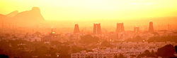
Coordinates 9°55′15.96″N 78°6′36″E / 9.9211°N 78.11°ECoordinates: 9°55′15.96″N 78°6′36″E / 9.9211°N 78.11°E Country India State Tamil Nadu Headquarters Madurai Largest city Madurai Collector Mr.U Sagayam IAS Parliamentary constituency 1 Assembly constituency 10 Municipal Corporations Madurai Population
• Density
3,041,038[1] (2011[update])
• 823 /km2 (2,132 /sq mi) (2011[update])
Sex ratio M-50.5%/F-49.5% ♂/♀ Literacy
• Male
• Female81.5%%
• 86.55%%
• 76.74%%Language(s) Tamil, Telegu, Sourashtra, English, Hindi Time zone IST (UTC+05:30) Area
• Coastline
3,741.73 square kilometres (1,444.69 sq mi)
• 0 kilometres (0 mi)
Website Official website of Madurai District Madurai district (Tamil: மதுரை மாவட்டம்) is one of the 32 districts of the state of Tamil Nadu, in southeastern India. The city of Madurai serves as the district headquarters. It houses the world famous Sri Meenakshi Sundareshwarar temple and is situated on the banks of river Vaigai. Thiruparankundram is one of the major tourist place in the district. Kazimar Periya Pallivasal and Madurai Maqbara in Kazimar Street are the oldest and major Islamic symbols in the city.
Contents
History
Madurai, also known as "Athens of the East". The main kingdoms which ruled Madurai during various times are the Pandyas and the Nayaks. Madurai is nicknamed "Thoonga Nagaram", roughly translated as, "city that never sleeps". Madurai called as temple city
Blocks
Madurai district comprises 13 Blocks.The Blocks become the best part of administration due to the number of villages in the district where rural administration is done by the Block hq. The Blocks are sub-divided by Firkas
- Thiruparankundram -- 7 Revenue Firkas
- T.Kallupatti -- 3 Revenue Firkas
- Tirumangalam -- 3 Revenue Firkas
- Kalligudi
- Sedapatti
- Usilampatti
- Vadipatti
- Melur
- Madurai West
- Madurai East
- Kottampatti
- Alanganallur
- Chellampatti[3]
Divisions
 Bull Taming, Alanganallur
Madurai district comprises seven Taluks.
- Madurai (North)
- Madurai (South)
- Tirumangalam
- Peraiyur
- Usilampatti
- Vadipatti
- Melur
Political Divisions
Assembly
ConstituencyPolitical
PartyElected
RepresentativeThirupparankundram DMDK A. K. T. Raja Usilampatti AIFB P. V. Kathiravan Madurai North AIADMK A. K. Bose Melur AIADMK R. Samy Madurai East AIADMK K. Tamilarasan Madurai Central DMDK R.Sundarrajan Sholavandan AIADMK M. V. Karuppaiah Tirumangalam AIADMK M. Muthuramalingam Madurai South CPI-M R. Annadurai Madurai West AIADMK K. Raju Lok Sabha
ConstituencyPolitical
PartyElected
RepresentativeMadurai DMK M.K. Azhagiri Source: Indian Elections / Election Commission of India.[4][5] Demographics
According to the 2011 census Madurai district has a population of 3,041,038,[6] roughly equal to the nation of Oman[7] or the US state of Iowa.[8] This gives it a ranking of 119th in India (out of a total of 640).[6] The district has a population density of 823 inhabitants per square kilometre (2,130 /sq mi) .[6] Its population growth rate over the decade 2001-2011 was 17.95 %.[6] Madurai has a sex ratio of 990 females for every 1000 males,[6] and a literacy rate of 81.66 %.[6]
Madurai district population is about 3,041,038 as of 2011,[9] with a decennial growth rate of 18%. The 60% of the district is urbanised, and the literacy rate of the district is about 81.7%.
Tourist attraction
- Kutladampatti falls
Geography
Climate
Madurai Climate chart (explanation) J F M A M J J A S O N D 2030201432211835235537257037264036265036251043525119342418832241453023512921Average max. and min. temperatures in °C Precipitation totals in mm Imperial conversion J F M A M J J A S O N D 0.886680.590700.795732.299772.899791.697791.996774.195774.793757.490755.7867328470Average max. and min. temperatures in °F Precipitation totals in inches References
- ^ "2011 Census of India" (Excel). Indian government. 16 April 2011. http://www.censusindia.gov.in/2011-prov-results/prov_data_products_tamilnadu.html.
- ^ www.tn.gov.in
- ^ http://www.madurai.tn.nic.in/block.html
- ^ "Election results". Indian Elections. http://www.indian-elections.com/assembly-elections/tamil-nadu/election-result-06.html.
- ^ "Parties Statistics". Election Commission of India. http://www.eci.gov.in/StatisticalReports/ElectionStatistics.asp.
- ^ a b c d e f "District Census 2011". Census2011.co.in. 2011. http://www.census2011.co.in/district.php. Retrieved 2011-09-30.
- ^ US Directorate of Intelligence. "Country Comparison:Population". https://www.cia.gov/library/publications/the-world-factbook/rankorder/2119rank.html. Retrieved 2011-10-01. "Oman 3,027,959"
- ^ "2010 Resident Population Data". U. S. Census Bureau. http://2010.census.gov/2010census/data/apportionment-pop-text.php. Retrieved 2011-09-30. "Iowa 3,046,355"
- ^ [1]
External links

Dindigul district Tiruchirappalli district Theni district 
Sivaganga district  Madurai district

Virudhunagar district Country State Region Pandya NaduTaluks Revenue blocks Alanganallur · Chellampatti · Kallikudi · Kottampatti · Madurai East · Madurai West · Melur · Sedapatti · T.Kallupatti · Thirumangalam · Thirupparankunram · Usilampatti · VadipattiHistory Early Cholas · Kalabhras · Pallavas · Medieval Cholas · Later Cholas · Later Pandyas · Delhi Sultanate · Madurai Sultanate · Vijayanagar Empire · Thanjavur Nayaks · Thanjavur Marathas · Company Raj · British RajPlaces of Worship Meenakshi Amman Temple · Edaganathar temple · Goripalayam Mosque · Kazimar Big Mosque · Thiruvedagam · Alagar Koyil · Koodal Azhagar Temple · Pazhamudircholai · Thirupparamkunram Murugan TemplePlaces of interest Universities Cities and towns · People · Villages
Categories:


Wikimedia Foundation. 2010.