Needles Ferry

Needles Ferry
Needles Ferry

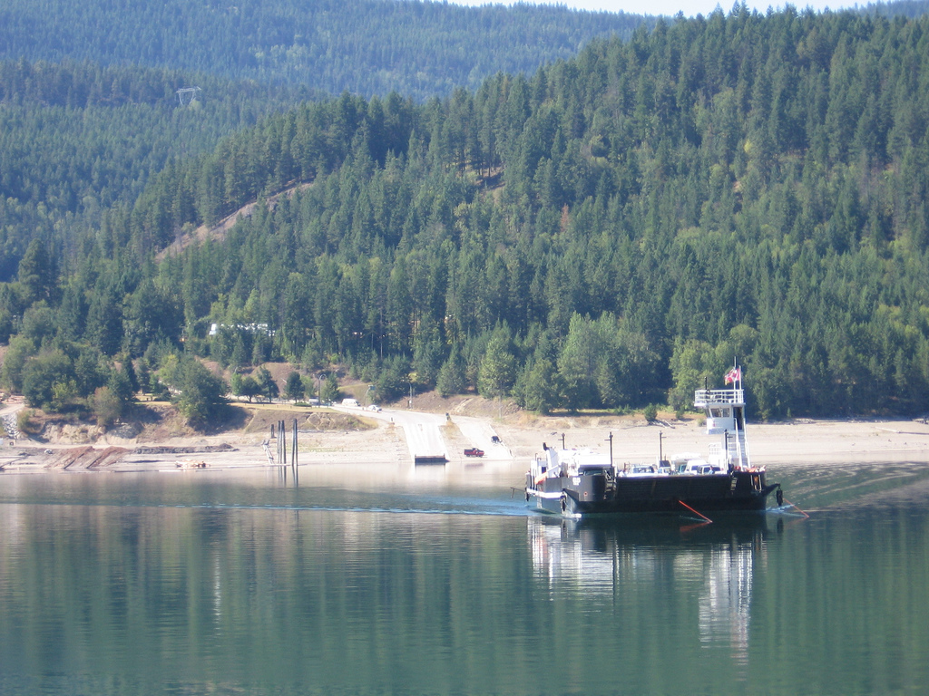
The Needles Ferry is a cable ferry across Lower Arrow Lake in British Columbia, Canada. It is situated 59 kilometres (37 mi) south of Nakusp and links Needles and Fauquier.[1]

Contents

Operation

The ferry operates under contract to the British Columbia Ministry of Transportation and is free of tolls. It travels back and forth every thirty minutes, from the first departure at 5am until the last departure at 10pm, with a crossing time of about five minutes. The ferry has capacity for 30 vehicles and 144 passengers.[1]

The ferry is diesel powered and pulls using a winding drum on a pair of 1-inch-diameter (25 mm) cables, plastic coated to prevent wear, which are suspended in the lake. The crossing is about 1 kilometre (0.62 mi) in length.

History

A ferry has been in operation from Needles since 1913.[2] Early farmers built the first ferry using Ford Model T parts. A small community in Needles, which pre-dated the ferry, was an area of fruit trees and scrub farming. Farmers provided fruit and vegetables to the mines of the Lardeau district (between Upper Arrow Lake and the head of Kootenay Lake). Canadian Pacific Railway lake steamers connected the farms to Arrowhead and Robson. The valley was flooded in the late 1960s by the construction of the Hugh Keenleyside Dam at Castlegar in the 1960s, leading people to abandon the town, after being expropriated from the lakeshore by Hydro. The ferry landing and a small cemetery are all that remain.[3]

Fauquier is the "centre" of the area that includes Edgewood and Burton with a few houses, gas station and grocery store.

See also

References

  1. ^ a b "Inland Ferry Schedules". Province of British Columbia. http://www.th.gov.bc.ca/marine/ferry_schedules.htm. Retrieved 2008-11-25. 
  2. ^ Marquardt, Riel (2006). The Backroad Chronicles: Adventure & History in British Columbia. Vol. I. Trafford Publishing. pp. 101. ISBN 9781412059039. http://books.google.ca/books?id=2drLxy7RsHUC. 
  3. ^ Needles Cemetery

External links


Coordinates: 49°52′24″N 118°06′03″W / 49.87333°N 118.10083°W / 49.87333; -118.10083


Wikimedia Foundation. 2010.

Игры ⚽ Нужно сделать НИР?

Look at other dictionaries:

  • Cable ferry — Coin operated cable ferry at Espevær in Bømlo, Norway A cable ferry is guided and in many cases propelled across a river or other larger body of water by cables connected to both shores. They are also called chain ferries, floating bridges, or… …   Wikipedia

  • Lee's Ferry — (also Lees Ferry or Lee Ferry) is a site on the Colorado River in Coconino County, Arizona, United States, about 12 km southwest of the town of Page, Arizona and the Glen Canyon Dam, and about 15 km south of the Utah Arizona border. It is the… …   Wikipedia

  • Frankie Yale — Infobox Person name=Francesco Ioele image size = 200px caption= NYPD mugshot of Frankie Yale birth date=1893 birth place=Longobucco, Calabria, Italy death date=death date|1928|7|1|mf=y Aged 34 or 35. death place=Brooklyn, New York, U.S.Francesco… …   Wikipedia

  • White Hand Gang — The White Hand Gang was a collection of the various Irish gangs operating on the New York Brooklyn and Red Hook waterfront from the early 1900s to 1925 organizing against the growing dominance of the Italian Black Hand (known as La Mano Nera).… …   Wikipedia

  • White Hand Gang — Als White Hand Gang wird eine Bande irischstämmiger Angehöriger in Brooklyn, New York City bezeichnet, die von 1900–1925 vor allem die „Waterfront“ des Stadtteils Red Hook kontrollierten. Geschichte Der Zusammenschluss war eine Reaktion auf die… …   Deutsch Wikipedia

  • Whatshan River — The Whatshan River is a tributary of the Columbia River in the Canadian province of British Columbia. The river s drainage basin is approximately convert|390|km2|sqmi in area.cite web |title = Whatshan Project Water Use Plan | publisher = BC… …   Wikipedia

  • List of crossings of the Columbia River — This is a list of bridges and other crossings of the Columbia River from the Pacific Ocean upstream to its source. Contents 1 Crossings 1.1 Oregon Washington 1.2 Washington 1.3 …   Wikipedia

  • Liste de ponts sur le Columbia — Article principal : Columbia (fleuve). Liste de ponts sur le fleuve Columbia classés de l aval à l amont. La liste comprend également des traversées en ferry et les barrages qui permettent un passage. Sommaire 1 Oregon Washington 2… …   Wikipédia en Français

  • Yarmouth bus station — is a facility for buses and coaches to wait for passengers in the town of Yarmouth on the Isle of Wight. It is conveniently located next to the Lymington ferry terminal allowing passengers arriving from and departing for the UK s mainland to… …   Wikipedia

  • List of California Historical Landmarks — This is a list of California Historical Landmarks. The official list may be seen [http://ohp.parks.ca.gov/listed resources/?view=all here] . NOTOC · =Alameda County= For more details, please see http://ohp.parks.ca.gov/default.asp?page id=21388.… …   Wikipedia

Share the article and excerpts

Direct link
Do a right-click on the link above
and select “Copy Link”