- Martlesham Heath
-
Coordinates: 52°03′40″N 1°16′21″E / 52.061177°N 1.272471°E
Martlesham Heath 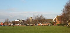
Martlesham Heath village green and centre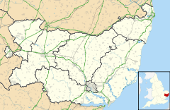
 Martlesham Heath
Martlesham Heath shown within SuffolkOS grid reference TM244453 District Suffolk Coastal Shire county Suffolk Region East Country England Sovereign state United Kingdom Post town IPSWICH Postcode district IP5 Dialling code 01473 Police Suffolk Fire Suffolk Ambulance East of England EU Parliament East of England UK Parliament Suffolk Coastal List of places: UK • England • Suffolk Martlesham Heath village is situated 6 miles east of Ipswich, in Suffolk, England. This was an ancient area of heathland and latterly the site of Martlesham Heath Airfield. A "new village" was established there in the mid-1970s and this has developed into a modern community, based on a traditional village pattern.
Contents
History
There is evidence of settlement in this area since the Bronze Age, with a number of round barrows surviving to the present. The main community of Martlesham grew up to the north-east, initially on the highest ground, where Martlesham Church is still located, then, later, centring on the point where the main London-to-Yarmouth road crosses the River Finn, a tributary to the Deben.
White's 1844 directory of Suffolk describes Martlesham as "a neat village near the confluence of a rivulet with the Deben" but mentions that the parish includes "a large, sandy, and unenclosed heath, extending about 2 miles S.W., and affording pasturage for numerous herds of sheep and cattle."
Martlesham Heath Airfield
Main article: RAF Martlesham HeathIn 1917, the Experimental Aircraft Flight of the Central Flying School was transferred from Upavon, Wiltshire to a site on the heathland at Martlesham and, on 16 January, 1917, Martlesham Heath Airfield was officially opened, as an experimental airfield. The unit was renamed the "Aeroplane Experimental Unit, Royal Flying Corps". After the end of World War I the site continued to be used and was, once again, renamed as the Aeroplane and Armament Experimental Establishment (A&AEE) of the Royal Air Force.
At the outbreak of the Second World War, the A&AEE was removed to a site at Boscombe Down, Hampshire, owing to the proximity of Martlesham Heath to the East Coast and its vulnerability to enemy attack. The airfield then took on a new role as a base for fighter squadrons defending Britain. Wing Commander (later Group Captain) Douglas Bader, D.S.O., D.F.C. served at Martlesham Heath with 222 and 242 Squadrons, in 1940.
At the end of hostilities, there was no longer a role for Martlesham Heath as an operational RAF airfield and no prospect of the A&AEE returning, but the site was again used for a number of experiments with planes and armaments. However, its use declined in the 1950s, and the airfield was closed in the early 1960s.
Various proposals were put forward for the development of the site, including the proposal that it should become a civil airport. Parts of the old airfield were let out to light industry and storage companies. In 1963 the lease of the site was sold by the Air Ministry to Bradford Property Trust Ltd, for a price of £72,500.
Adastral Park
Main article: Adastral ParkIn 1968, the Post Office purchased part of the airfield and surrounding farmland and announced that they would be relocating their Research Department from Dollis Hill to a new centre to be built at Martlesham Heath. The building work took place in the early 1970s and this site has remained as the central research and development facility through the changes that have taken place with the separation of British Telecom from the Post Office and the privatisation of British Telcommunications. In the 1980s, the facility was renamed as BT Labs and was subsequently developed into a high tech business park called Adastral Park in the 1990s.
New village
In 1972 a proposal was presented by Bradford Property Trust to the Planning Department of the local council to develop a "New Village" of Martlesham Heath, with houses for 3000 people, with associated shops, schools and recreational facilities. This was accepted and has resulted in the development of the present community of Martlesham Heath. The vision of this development was to create a completely new community, but based on a traditional pattern. Hence, the village is centred on a village green, with a pub, church and cricket pavilion. In order to maintain a consistent appearance as a village, homeowners at Martlesham Heath are restricted by covenants which govern changes that they can make to their houses and gardens: for example, residents are prevented from attaching external television aerials to their houses. However, many have erected satellite TV dishes, since these were not foreseen when the covenants were written and are therefore allowed. A cable TV system was built into the development (originally provided by BT but later sold to NTL) which was the best option before satellite, since it was provided at cost price and off-air broadcasts had poor reception.
This area is mostly prosperous, with most homeowners having a higher income than the national average. However, there are a few areas with higher levels of socio-economic deprivation.[citation needed]
The new village of Martlesham Heath is with both the administrative and ecclesiastical Parish of Martlesham
Transportation
There is no station in Martlesham Heath, but there are several bus services. These are: 63, 64, 65, 66, 70, 70A, 165, 178 and 179.
Services 63, 64, 65, 66, 70, 165 and 178 all go to Ipswich and service 62A, 62B and 66 operate through the evenings.
Services 63, 64, 65, 70A, 165, 178 and 179 all go to Woodbridge and service 62A, 62B operate through the evenings.
References
- David Dymond and Peter Northeast: A History of Suffolk, Phillimore, 1985. ISBN 0-85033-482-9
- William White: History, Gazetteer, and Directory of Suffolk, 1844
- Gordon Kinsey: Martlesham Heath, Terence Dalton Ltd, 1975. ISBN 0-900963-48-4
- Paul Firman: Martlesham - The Good and Bad Old Days, The Martlesham Monthly, ISBN 0-9542004-0-3
- Suffolk County Council: Martlesham Electoral Division Profile http://www.suffolk.gov.uk/NR/rdonlyres/F3AE2F7D-6C7D-427A-8078-EC8757BAB0C0/202444/52MartleshamElectoralDivisionprofile.pdf extracted June 2001
External links
 Media related to Martlesham Heath at Wikimedia CommonsCategories:
- Villages in Suffolk


Wikimedia Foundation. 2010.