- Maryland Route 227
-
Maryland Route 227

Map of Southern Maryland with MD 227 highlighted in redRoute information Maintained by MDSHA Length: 13.96 mi[1] (22.47 km) Major junctions West end: Road end at Marshall Hall  MD 210 in Bryans Road
 MD 224 in Pomonkey
 MD 229 near Pomfret
East end:  US 301 in White Plains
Location Counties: Charles Highway system Maryland highway system
Interstate • US • State • Minor • Former • Turnpikes←  MD 225
MD 228  →
→Maryland Route 227 (MD 227) is a state highway in the U.S. state of Maryland. The state highway runs 13.96 miles (22.47 km) from Marshall Hall east to U.S. Route 301 (US 301) in White Plains. MD 227 connects the communities of Bryans Road, Pomonkey, and Pomfret in northwestern Charles County. The state highway, which was constructed in the mid 1920s and early 1930s, originally had its western terminus at Pomonkey; the remainder of the current route was part of MD 224 and all of MD 226. MD 227 gained its present western terminus in the mid 1950s.
Contents
Route description
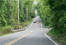 MD 227 eastbound at intersection with Brierwood Road
MD 227 begins at a boat ramp on the Potomac River adjacent to the ruins of the namesake mansion at Marshall Hall within Piscataway Park. The state highway heads south as Marshall Hall Road, a two-lane road through a forested area. MD 227 crosses Mill Swamp and begins to pass residential subdivisions as the highway approaches the community of Bryans Road, where the highway intersections MD 210 (Indian Head Highway). The state highway continues south as Livingston Road to Pomonkey, where MD 224 continues southwest as Livingston Road toward Mason Springs while MD 227 veers southeast as Pomfret Road. The state highway crosses Mattawoman Creek, passes by the historic farm McPherson's Purchase, and intersects the Indian Head Rail Trail on its way to Pomfret, where the highway meets Marshall Corner Road. MD 227 turns north onto Marshall Corner Road, curving to the east and passing the entrance to Green's Inheritance before meeting the southern end of MD 229 (Bensville Road). East of Pomfret, the state highway passes close to another pair of historic homes, Pleasant Hill and Oak Grove, the latter of which is on the intersecting Turkey Hill Road. MD 227 crosses Pages Swamp and passes close to another historic home, Spye Park, before reaching White Plains, where the state highway reaches its eastern terminus at US 301 (Robert Crain Highway) opposite county-maintained Willetts Crossing Road.[1][2]
History
Present-day MD 227 was built as part of three different state highways. Livingston Road between Bryans Road and Pomonkey was constructed around 1923 as part of MD 224, which originally ran from MD 6 at Doncaster to the District of Columbia in Forest Heights.[3][4] Marshall Hall Road was built as MD 226 between 1924 and 1927.[5][6] MD 227's portion of Marshall Corner Road was constructed between 1924 and 1926.[5][6] The final portion of MD 227, Pomfret Road, was started in 1929 and complete from Marshall Corner Road to the bridge over Mattawoman Creek in 1930.[7][8] The gap between Mattawoman Creek and Livingston Road was filled by 1933.[9] MD 227 was extended north over Livingston Road and Marshall Hall Road to its present western terminus, taking over all of MD 226's course, in 1956.[10]
Junction list
The entire route is in Charles County.
Location Mile[1] Destinations Notes Marshall Hall 0.00 Road end at Potomac River Western terminus Bryans Road 4.51 MD 210 (Indian Head Highway) – Indian Head, WashingtonPomonkey 5.84 MD 224 south (Livingston Road) – Mason SpringsPomfret 9.04 Marshall Corner Road south MD 227 turns north onto Marshall Corner Road 10.16 MD 229 north (Bensville Road) – BennsvilleWhite Plains 13.96 US 301 (Robert Crain Highway) / Willetts Crossing Road south – Waldorf, La PlataEastern terminus 1.000 mi = 1.609 km; 1.000 km = 0.621 mi References
- ^ a b c "Highway Location Reference: Charles County" (PDF). Maryland State Highway Administration. 2009. http://www.marylandroads.com/Location/2009_CHARLES.pdf. Retrieved 2011-01-11.
- ^ Google, Inc. Google Maps – Maryland Route 227 (Map). Cartography by Google, Inc. http://maps.google.com/maps?f=d&source=s_d&saddr=MD-227+E%2FMarshall+Hall+Boat+Ramp&daddr=MD-227+E%2FMarshall+Corner+Rd&geocode=FRBKTgIdxIhn-w%3BFbC6TAIdxNFp-w&hl=en&mra=ls&sll=38.631325,-77.02598&sspn=0.123102,0.308647&ie=UTF8&t=h&z=12. Retrieved 2011-01-11.
- ^ Maryland State Roads Commission. General Highway Map: State of Maryland (Map) (1939 ed.).
- ^ Maryland Geological Survey. Map of Maryland: Showing State Road System and State Aid Roads (Map) (1923 ed.).
- ^ a b Report of the State Roads Commission of Maryland. 1924-1926. Baltimore: Maryland State Roads Commission. January 1927. pp. 41, 77. http://www.archive.org/details/annualreportsofs1924mary. Retrieved 2011-01-11.
- ^ a b Maryland Geological Survey. Map of Maryland: Showing State Road System and State Aid Roads (Map) (1927 ed.).
- ^ Report of the State Roads Commission of Maryland. 1927-1930. Baltimore: Maryland State Roads Commission. 1930-10-01. pp. 206–207. http://www.archive.org/details/reportofstateroa1927mary. Retrieved 2011-01-11.
- ^ Maryland Geological Survey. Map of Maryland Showing State Road System: State Aid Roads and Improved County Road Connections (Map) (1930 ed.).
- ^ Maryland Geological Survey. Map of Maryland Showing State Road System: State Aid Roads and Improved County Road Connections (Map) (1933 ed.).
- ^ Maryland State Roads Commission. Maryland: Official Highway Map (Map) (1956 ed.).
External links
Roads in Charles County, Maryland State highways 
U.S. Highways Categories:- State highways in Maryland
- Roads in Charles County, Maryland


Wikimedia Foundation. 2010.