- Wiveliscombe
-
Coordinates: 51°02′35″N 3°18′49″W / 51.0431°N 3.3137°W
Wiveliscombe 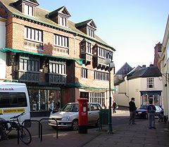
Court House, Wiveliscombe, built by the Hancock family (a local brewing family) in 1881[1]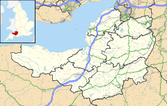
 Wiveliscombe
Wiveliscombe shown within SomersetPopulation 2,670 [2] OS grid reference ST080279 District Taunton Deane Shire county Somerset Region South West Country England Sovereign state United Kingdom Post town TAUNTON Postcode district TA4 Dialling code 01984 Police Avon and Somerset Fire Devon and Somerset Ambulance South Western EU Parliament South West England UK Parliament Taunton Deane List of places: UK • England • Somerset Wiveliscombe is a town and civil parish in Somerset, England, situated 9 miles (14 km) west of Taunton in the Taunton Deane district. The town has a population of 2,670.[2] The parish includes the nearby hamlet of Maundown.
Contents
History
North west of the town are Clatworthy Camp an Iron age hill fort and Clatworthy Reservoir. Nearby is Elworthy Barrows an unfinished Iron Age hill fort rather than Bronze Age barrows.[3] The Neolithic hillfort at King's Castle is 1 kilometre (0.62 mi) east of the town.
The parish of Wiveliscombe was part of the Kilmersdon Hundred,[4]
The Town Hall was built in 1840 by Richard Carver for Lord Ashburton. It housed a fish market, a butchers’ market and a pig market with an assembly room above them. It is a Grade II listed building.[5] It was bought by The Cooperative Society in 1929 and converted to shops, with the hall being left unused. Plans have now been drawn up for the creation of an Arts, Media, Cultural and Heritage Venue.[6]
In 2010 a new 10 Parishes Centre was announced which will provide a new community facility alongside the Children’s Centre being built at Croft Way.[7]
Governance
The parish council has responsibility for local issues, including setting an annual precept (local rate) to cover the council’s operating costs and producing annual accounts for public scrutiny. The parish council evaluates local planning applications and works with the local police, district council officers, and neighbourhood watch groups on matters of crime, security, and traffic. The parish council's role also includes initiating projects for the maintenance and repair of parish facilities, as well as consulting with the district council on the maintenance, repair, and improvement of highways, drainage, footpaths, public transport, and street cleaning. Conservation matters (including trees and listed buildings) and environmental issues are also the responsibility of the council.
The town falls within the Non-metropolitan district of Taunton Deane, which was formed on April 1, 1974 under the Local Government Act 1972, having previously been part of Wellington Rural District.[8] The district council is responsible for local planning and building control, local roads, council housing, environmental health, markets and fairs, refuse collection and recycling, cemeteries and crematoria, leisure services, parks, and tourism.
Somerset County Council is responsible for running the largest and most expensive local services such as education, social services, libraries, main roads, public transport, policing and fire services, trading standards, waste disposal and strategic planning.
It is also part of the Taunton Deane county constituency represented in the House of Commons of the Parliament of the United Kingdom. It elects one Member of Parliament (MP) by the first past the post system of election, and part of the South West England constituency of the European Parliament which elects six MEPs using the d'Hondt method of party-list proportional representation.
Geography
Wiveliscombe is a former borough, market and cloth making town just 5 miles (8 km) from the border between Devon and Somerset. It is situated at the foot of the Brendon Hills and acts as a gateway to Exmoor.
The town used to have a station on the Devon and Somerset Railway which closed in 1966.
Demographics
While the population of 2,670 is small for a town, the shops and services meet the needs of a much larger population, spread through the western fifth of Taunton Deane, in scattered farms and villages. A survey in 1997 revealed that there were at least 300 businesses within a 5 miles (8 km) mile radius of the town; 14 of these were trading internationally and a further 20 nationally. Wiveliscombe is also home to two breweries, Cotleigh Brewery and Exmoor Ales. It is also one of the first towns in the UK to set up a completely free goods and services exchange forum for the local ten parishes area.[9] The community radio station 10radio is based in the town, serving the community of the ten parishes from which its name is derived.
Churches
 The tower of St Andrews church
The Church of St Andrew dates from 1827-9 and was built from red sandstone with Hamstone dressings, although the font is octagonal and originated in the 14th century. The architect was Richard Carver. The church has been designated by English Heritage as a grade II* listed building.[10]
Within the churchyard is a 14th century Sandstone cross.[11]
The oldest place of worship in Wiveliscombe is the Congregational Chapel in Silver Street, built in 1708 as the Independent Chapel. It joined the Congregational Union of England and Wales in 1838, and today is home to the Wiveliscombe Evangelical Congregational Church. This chapel was built because the Independent Meeting House (built in 1689 after the Act of Toleration) had become too small. This earlier Meeting House was demolished sometime after the First World War, when North Street Motors was built on the site. This has now closed, and the premises are currently being used as a garden shop.
Education
Wiveliscombe Primary School serves most of the surrounding villages. Kingsmead School, for pupils aged 11 to 16, houses a Theatre and Sports Hall and a youth club complementing the town's Recreation Ground where the Tennis, Rugby, Cricket and Football Clubs have their bases.
References
- ^ "Nos 5 & 7 The Square". Images of England. http://www.imagesofengland.org.uk/details/default.aspx?id=270167. Retrieved 2008-02-16.
- ^ a b "Taunton Deane 2002 parish population estimates". Somerset County Council. http://www.webcitation.org/5lRyCZwqu. Retrieved 27 December 2009.
- ^ Barrow, "Hllforts and hilltops 1000BC - 1000AD" in Aston and Burrow, The Archaeology of Somerset (1982)
- ^ "Somerset Hundreds". GENUKI. http://www.genuki.org.uk/big/eng/SOM/Miscellaneous/. Retrieved 16 October 2011.
- ^ "Town Hall". Images of England. English Heritage. http://www.imagesofengland.org.uk/Details/Default.aspx?id=270163. Retrieved 14 May 2010.
- ^ "Wiveliscombe town hall". Somerset Rural Renaissance. http://www.somerset-rural-renaissance.co.uk/wiveliscombe-town-hall.html. Retrieved 14 May 2010.
- ^ "Building links at Wiveliscombe". Somerset Rural Renaissance. http://www.somerset-rural-renaissance.co.uk/projects-building-links-wiveliscombe.html. Retrieved 14 May 2010.
- ^ A Vision of Britain Through Time : Wellington Rural District
- ^ "Wiveliscombe". Somerset Market Towns. http://www.somersetmarkettowns.co.uk/town/wiveliscombe. Retrieved 2008-07-09.
- ^ "Church of St Andrew". Images of England. http://www.imagesofengland.org.uk/details/default.aspx?id=270127. Retrieved 2008-02-15.
- ^ "Churchyard cross, Church of St Andrew". Images of England. http://www.imagesofengland.org.uk/details/default.aspx?id=270129. Retrieved 2008-02-16.
External links
- Wiveliscombe at the Open Directory Project
- Wiveliscombe at The Somerset Urban Archaeological Survey, by Clare Gathercole
Towns, villages and hamlets in the Taunton Deane borough of Somerset, England  Ashbrittle · Ash Priors · Bathealton · Bickenhall · Bishop's Hull · Bishops Lydeard · Bradford on Tone · Burrowbridge · Cheddon Fitzpaine · Chipstable · Churchstanton · Combe Florey · Comeytrowe · Corfe · Cotford St Luke · Cothelstone · Creech St Michael · Curland · Durston · Fitzhead · Halse · Hatch Beauchamp · Kingston St Mary · Langford Budville · Lydeard St Lawrence · Milverton · North Curry · Norton Fitzwarren · Nynehead · Oake · Orchard Portman · Otterford · Pitminster · Ruishton · Sampford Arundel · Staple Fitzpaine · Stawley · Stoke St Gregory · Stoke St Mary · Taunton · Thornfalcon · Tolland · Trull · Wellington · Wellington Without · West Bagborough · West Buckland · West Hatch · West Monkton · WiveliscombeCategories:
- Towns in Taunton Deane
- Civil parishes in Somerset


Wikimedia Foundation. 2010.