- Molave, Zamboanga del Sur
-
- "Molave" redirects here. This can also refer to the wood of 'Vitex cofassus and Vitex parviflora.
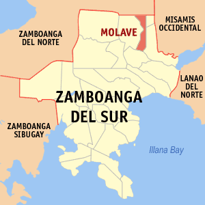
Molave — Municipality — Map of Zamboanga del Sur showing the location of Molave Location in the Philippines
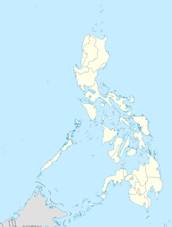
 Molave
Coordinates: 8°05′N 123°29′E / 8.083°N 123.483°ECoordinates: 8°05′N 123°29′E / 8.083°N 123.483°E Country  Philippines
Region Western Mindanao (Region IX) Province Zamboanga del Sur District 1st District of Zamboanga del Sur Founded June 16, 1948 Barangays 25 Government - Mayor Ireneo Q. Glepa Area - Total 251.50 km2 (97.1 sq mi) Population (2007) - Total 48,215 - Density 191.7/km2 (496.5/sq mi) Time zone PST (UTC+8) ZIP code Income class 1st class town; Partially Urban Molave is a 1st class municipality in the province of Zamboanga del Sur, Philippines. It has a population of 48,215 as of Aug 1, 2007 census. The name "Molave" refers to the hard, strong and resilient tree that abounds in the place during the 1950s. It was created through the efforts of Congressman Juan Alano, as a daughter municipality of Aurora by Republic Act No. 286 on June 16, 1948.[1] Molave is located in the eastern part of the province of Zamboanga del Sur. It has a total land area of 21,685 hectares.
Molave was designated as the new capital of the province of Zamboanga when it was created in June 16, 1948.[2]Molave served as its capital until Zamboanga's division into Zamboanga del Norte and Zamboanga del Sur. Molave came under the Zamboanga del Sur with the town of Pagadian as its capital.
Molave is politically subdivided into 25 barangays.
- Alicia
- Ariosa
- Bagong Argao
- Bagong Gutlang
- Blancia
- Bogo Capalaran
- Culo
- Dalaon
- Dipolo
- Dontulan
- Gonosan
- Lower Dimalinao
- Lower Dimorok
- Mabuhay
- Madasigon (Pob.)
- Makuguihon (Pob.)
- Maloloy-on (Pob.)
- Miligan
- Parasan
- Rizal
- Santo Rosario
- Silangit
- Simata
- Sudlon
- Upper Dimorok
Contents
Geographical Location
Molave is located in the eastern part of the Province of Zamboanga del Sur. It is bounded by the municipalities of Tambulig in the east, Mahayag in the west, Josefina and Province of Zamboanga del Norte in the north and Ramon Magsaysay in the south. It is approximately 38 km from its capital Pagadian City and 58 km to Ozamis City. It is situated on longitude 123 deg 29 min 50 sec, latitude 7 deg 5 min 50 sec and is 15 meters above sea level.
Climate
As shown in the climatologic map of PAG-ASA, Molave is of 4th type where rainfall is evenly distributed throughout the year. The area has a fairly warm temperature having an average temperature of 29.7 degrees Celsius.
Topography
Topography/Slope:
Molave is divided into two topographical areas, namely: the lowland area which covers 30% of the total land area is composed of nine (9) barangays and is situated in the east and southwest portion is generally flat, swampy and marshy; while the upland portion which covers 70% of the total land area is hilly and mostly deforested. The terrain and slope pattern is moderately sloping to rolling with 2 slope variations from 10% in the lowland to 27% in the mountainous areas.
Soil Type:
There are two types of soil found within the municipality. In the lowland areas and part of the upper barangays, the type of soil is San Miguel Silt Loam. Adtoyon Clay Loam is found in the upland areas. San Miguel Silt Loam is best suited for cultivation and requires only simple and good farm management practice. The other kind of soil which is the Adtoyon Clay Loam can be used for grazing and diversified crops like corn, cassava, camote, etc.
Historical Background
Nestled at the foot of a verdant hill and bounded by Salug Diut River and mountain ranges that makes it free from typhoons, is the municipality of Molave which has been the hub of commerce and center of trade in the eastern part of Zamboanga del Sur particularly the Salug Valley area. Its name was taken after a hardwood, the Molave tree that abounds in the place during its early days. Its creation started in the early thirties as a small patch of settlement in a marshy jungle that was originally known as Salug. The fertile land in the Salug Valley attracted more settlers from distant places of Luzon, Visayas and Mindanao which made it a conglomeration of Cebuano, Boholano, Ilongo, Tagalog, Ilocano, Leyteño, Misamisnon, Surigaonon and other different Muslim and ethnic groups. However, the Subanens were known to be the early settlers of this place. Many Chinese businessmen settled in this region before World War II and prospered.
The continuous influx of people from different places made possible the rapid development of this small start-up settlement. Then by June 16, 1948, Molave was created into a municipality by virtue of Republic Act No. 286 authored by the late Cong. Juan S. Alano from its mother town Aurora.
The late Dr. Pelagio Blancia was the first mayor by appointment. He was defeated in the 1951 local elections and the newly elected Mayor Javier Ariosa transferred the seat of government from Camp 7 (now Barangay Blancia) to its present site.
Dr. Pelagio Blancia is a delegate with Roseller T. Lim and Lobregat to the 1971 Constitutional Convention. His wife Encarnacion Blancia who came from the Ortega Clan of Negros became mayor of the town.
It was during the 3 consecutive terms of Mayor Flavio 'Jun' Saniel, Jr. that Infrastructure projects were implemented. Mayor Saniel is the son of former town councilor Flavio Saniel, Sr. who hailed from Argao,Cebu. He rose from humble beginnings to the highest rank. He became a member and President of the Fraternal Order of Eagles in the Philippines.
Vice-Mayor Ireneo 'Loloy' Glepa is the incumbent mayor of this town. He is the son of the late Mr. Monico Glepa and Graciana Querque Glepa who owned Molave Bakery & Grocery back then, hailed from Dalaguete, Cebu and Aloran, Misamis Occidental respectively. A well beloved couple due to their kindness and generosity. Mayor I. Glepa once became the youngest and longest serving Vice-Mayor of Molave. He was unopposed for two terms as a vice mayor before being elected overwhelmingly in the last May 2010 election.
Economy
The town is the hub of commerce and trade in the Salug Valley area.
For year 2002, the municipal total income increased by 25% or an increase of P 9.9 million.
The municipal public market generated the highest income of P 3 million, followed by the water system with P 1.4 million and then the slaughterhouse having P 366,841.50.
When the local government unit earns revenues from taxes and its public economic enterprises, this shall mean more, bigger and better projects and programs for the people. Rice trading, milling and farming is a major industry in the area. It's rice supplies the Mindanao and Visayas areas even to Metro Manila. The towns of Midsalip, Sominot, Ramon Magsaysay, Aurora, Mahayag, Josefina, Dumingag, Sergio Osmeña , Don Victoriano , Tambulig, Bonifacio, Tangub City all converge to this bustling town due to its proximity, much cheaper goods and commodities than some major cities like Ozamis City and Pagadian City.
It has mall type establishments like Cinema Square and Juanita Enterprises. Ogis Lechon manok is based in this town with its Dressing Plant located in Mabuhay, Zamboanga del Sur. Molave Glass House owned by young enterprenuer Mr. Stephen Arapoc supplies Aluminum cladding to Visayas and Mindanao Area.
Agriculture
The municipality is basically an agricultural community where 91.85% of the total land area is devoted to agriculture. 1,378.50 hectares of fertile land is fully irrigated and planted with rice. Other agricultural crops are corn, coconut, cassava, banana, camote and various kinds of vegetables are produced within the locality and marketed to neighboring towns and cities and even reaching to Cebu. There are 23 farmer cooperatives within the municipality of which 19 are registered and 4 are not registered with a total of 7,566 farmer members. [1] However, commerce and industry activity of the municipality is fast developing due to its strategic location thus making it as the hub of commerce and trade of the Salug Valley area. Various large commercial and industrial establishments are sprouting within the poblacion area attracting more investors to engage business within the municipality.
Health
The municipality has 10 existing Barangay Health Stations, 1 lying-in (Maternity) clinic, 26 Health and Nutrition Posts and a Municipal Health Center, staffed by 1 rural health physician, 1 dentist, 1 sanitary inspector, 3 nurses and 11 midwives. Further, it has 3 private hospitals, 5 private clinics and 10 pharmacies. [2]
Lumapas Hospital ,Igano Community Hospital and Blancia Hospital are located in this bustling town with modern facilities.
Sports and Recreation
Sporting facilities include municipal gymnasium, 3 tennis courts, 4 basketball courts, 3 volleyball courts and a sports complex facility of the Molave Regional Pilot School. Providing recreation are the municipal plaza with its playground paraphernalia, and a landscaped tourism spot. A pylon stands at the heart of the plaza to serve as a landmark.
A Drive Range Golf Course is located 4 km. away from the town in barangay Parasan. Eriberta Springs is a favorite attraction located at Brgy. Diwan, Mahayag formely part of Molave.
Hotels like Alexxandra Hotel, Casa Maria Pension, Guest House and RJYM offers modern amenities to visitors and guests.
Night life is fun with La Pergola with delicious treats of Italian Foods and pastries and Resto-bar like in Alexxandra Hotel.
Barbecue stands and Karaoke stalls are located at the back of Molave Gymnasium.
Peace and Order
The Molave Municipal Police station has two (2) PCOs and twenty four (24) PNCOs serving the populace. This station has two (2) outposts/detachments situated at barangay Dipolo and Sudlon.
Molave is generally peaceful with a crime efficiency rate of 95% and 160 crime incidents reported as of 2007, a decrease of 5% or 8 crime incidents compared to 2006’s or last year’s one hundred sixty eight (168) crime incidents. The presence of the 10th Infantry Battalion of the 1st Infantry Division stationed at Barangay Bag-ong Argao and the 906th Provincial Mobile Group had help much in keeping its peaceful environment for the whole municipality and of Salug Valley area. [3]
Education
As center of education and culture, there are four (4) private pre-schools; twenty three (23) public and 1 private elementary school; six (6) primary schools; five secondary schools and 2 (1 private and 1 public) tertiary schools.
To meet the growing needs of young Molavenians for quality basic education, the LGU shouldered an equity of P600,000.00 for a six room 2-storey TEEP building for MRPS. At MVTS another six room 2-storey SEDIP building and a two room science laboratory have been built for P6.8M with the 10% equity put up by the joint efforts of the LGU and the PTCA whose president happens to be Mayor Saniel.
This linkage dates back to a time long before MVTS principal Dr. Linda M. Saniel assumed the leadership of MVTS.
All barangay Elementary and Secondary Schools have also been recipient of TEEP/SEDIP rehab or construction funds.
Colleges:
- Blancia Carreon College Foundation, Inc. [4]
- Western Mindanao State University - External Studies Unit, Molave
High Schools:
- Blancia Carreon College Foundation, Inc. (High School Department) [5]
- Molave Vocational Technical School (MVTS)
- Sacred Heart High School
- Parasan National High School
- Simata National High School
References
- ^ "An act creating the municipality of Molave in the province of Zamboanga and making said municipality the capital of the province". LawPH.com. http://lawph.com/statutes/ra286.html. Retrieved 2011-04-08.
- ^ "An act creating the municipality of Molave in the province of Zamboanga and making said municipality the capital of the province". LawPH.com. http://lawph.com/statutes/ra286.html. Retrieved 2011-04-08.
External links
- Philippine Standard Geographic Code
- 2000 Philippine Census Information
- Life 4 Water, Inc. Zamboanga Del Sur Projects
- [6]
Municipalities Aurora • Bayog • Dimataling • Dinas • Dumalinao • Dumingag • Guipos • Josefina • Kumalarang • Labangan • Lakewood • Lapuyan • Mahayag • Margosatubig • Midsalip • Molave • Pitogo • Ramon Magsaysay • San Miguel • San Pablo • Sominot • Tabina • Tambulig • Tigbao • Tukuran • Vincenzo A. SagunComponent city PagadianCategories:- Municipalities of Zamboanga del Sur

Wikimedia Foundation. 2010.