- Cuxhaven (district)
-
Cuxhaven — District — 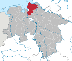
Country  Germany
State Lower Saxony Capital Cuxhaven Area - Total 2,073 km2 (800.4 sq mi) Population (31 December 2010)[1] - Total 200,464 - Density 96.7/km2 (250.5/sq mi) Time zone CET (UTC+1) - Summer (DST) CEST (UTC+2) Vehicle registration CUX Website landkreis-cuxhaven.de Cuxhaven is a district (Landkreis) in Lower Saxony, Germany. It is bounded by (from the east and clockwise) the districts of Stade, Rotenburg, Osterholz and Wesermarsch, the city of Bremerhaven and the North Sea.
Contents
History
The district was established in 1977 by merging the former districts of Land Hadeln and Wesermünde. The city of Cuxhaven lost its status as a district-free city and became the capital of the new district.
Geography
The District is often nicknamed "Cuxland". It is located on the coast of the North Sea and is enclosed by the river mouths of Elbe and Weser. The coasts are part of the Lower Saxony Wadden Sea National Park.
Coat of arms
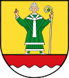
The arms display Saint Nicholas, who is the patron saint of fishermen. The coast of the North Sea is symbolised at the bottom of the arms. Cities and municipalities
Cities Samtgemeinden
Free municipalities- 1. Am Dobrock
- 2. Bederkesa
- 4. Hagen
- 5. Hemmoor
- Hechthausen
- Hemmoor1, 2
- Osten
- 6. Land Hadeln
- 7. Land Wursten
1seat of the Samtgemeinde; 2town References
- ^ "Bevölkerungsfortschreibung" (in German). Landesbetrieb für Statistik und Kommunikationstechnologie Niedersachsen. 31 December 2009. http://www1.nls.niedersachsen.de/statistik/html/parametereingabe.asp?DT=K1000014&CM=Bev%F6lkerungsfortschreibung.
External links
- Official website (German)
- Cuxland touristical website (German)
 Urban and rural districts in the state of Lower Saxony in Germany
Region HanoverUrban districts Rural districts Ammerland · Aurich · Bentheim · Celle · Cloppenburg · Cuxhaven · Diepholz · Emsland · Friesland · Gifhorn · Goslar · Göttingen · Hamelin-Pyrmont · Harburg · Heidekreis · Helmstedt · Hildesheim · Holzminden · Leer · Lüchow-Dannenberg · Lüneburg · Nienburg · Northeim · Oldenburg · Osnabrück · Osterholz · Osterode · Peine · Rotenburg · Schaumburg · Stade · Uelzen · Vechta · Verden · Wesermarsch · Wittmund · WolfenbüttelCategories:- Districts of Lower Saxony
- 1977 establishments
- Cuxhaven district


Wikimedia Foundation. 2010.