- List of storms in the 2007 Atlantic hurricane season
The
2007 Atlantic hurricane season was an event in the annual cycle oftropical cyclone formation. It officially startedJune 1 ,2007 , and endedNovember 30 ,2007 , dates that conventionally delimit the period when mosttropical cyclone s form in theAtlantic basin during the year. However, the formation of Subtropical Storm Andrea onMay 9 ,2007 marked an earlier beginning to the season, and the season extended past the official end of the season when Tropical Storm Olga developed onDecember 11 . The 2007 season was fairly active, with 15 named storms, though the intensities of the storms did not meet the predictions.hurricane season related|season=2007 Atlantic hurricane|list=yes
stats = yestorms
ubtropical Storm Andrea
Infobox Hurricane Small
Basin=Atl
Type=subtropical
Track=Andrea 2007 track.pngMay 9
Dissipated=May 11
1-min winds=50
Pressure=1001extratropical cyclone that formed off the mid-Atlantic coast onMay 6 deepened steadily along a cold front that pushed throughFlorida . When the system lost most of itsbaroclinic support, development ceased until its low moved into warmer waters near theBahamas . However, interaction between the low and a strong high-pressure system to the north generated hurricane-force winds in the system. Decreasing vertical wind shear allowed the storm to generate deeper convection much closer to the center.cite web|url=http://www.nhc.noaa.gov/pdf/TCR-AL012007_Andrea.pdf|title=Tropical Cyclone Report for Subtropical Storm Andrea|accessdate=2007-11-29|author=|Jaime R. Rhome|coauthors=Jack Bevin; Mark Willis|date=2007-06-01|publisher=National Hurricane Center] ByMay 9 the previouslyextratropical cyclone had transformed into Subtropical Storm Andrea while located about 140 miles (225 km) southeast of Savannah, Georgia.cite web|url=http://www.nhc.noaa.gov/archive/2007/al01/al012007.public.001.shtml?|title=Subtropical Storm Andrea Advisory 1|accessdate=2007-11-30|author=Knabb|date=2007-05-09|publisher=National Hurricane Center]Tropical storm watches were immediately issued for parts of coastal Georgia and
Florida , though all were later dropped. Andrea was the first named storm to form in May since Arlene in 1981, and the first pre-season storm since Ana in April 2003.cite web|url=http://www.hurricanecity.com/offseason.htm|title=Storms & Hurricanes in the off season|accessdate=2007-11-30|author=Unisys|publisher=Hurricane City] Andrea began its subtropical phase as it was weakening, and continued this deterioration as it moved southward into an environment with higher wind shear. ByMay 11 Andrea had lost all significant convection and degenerated into a remnant low. Though it produced intermittent bursts of convection, Andrea's chance of regeneration was extinguished when an advancing cold front pushed it northward and eventually absorbed the system.The storm produced rough surf and large waves along the coastline from
Florida toNorth Carolina , causing beach erosion and some damage.cite web|url=ftp://ftp.met.fsu.edu/pub/weather/tropical/Disturbance/2007050903.WONT41author=Brown|title=Special Tropical Disturbance Statement for May 9|publisher=National Hurricane Center|accessdate=2007-05-09|author=Brown|date=2007-05-08] No deaths were directly attributable to Andrea, though six people died from the waves generated during its extratropical phase. The storm was also blamed for high winds that could have fueled severe wildfires in northernFlorida and southern Georgia.cite news|url=http://www.orlandosentinel.com/news/local/state/orl-fire1207may12,0,3010146.story?coll=orl-news-headlines-state|title='Fire of a lifetime' hits North Florida|accessdate=2007-05-13|author=Kevin Spear and Jim Stratton|date=2007-05-12|publisher=Orlando Sentinel] However, because Andrea never made landfall, most of the resulting damage was associated with large waves, higher than normal tides, associated coastal flooding, and beach erosion caused by the storm.* See the NHC's [http://www.nhc.noaa.gov/archive/2007/ANDREA.shtml? advisory archive] on Subtropical Storm Andrea.
* See NHC's end-of-season [http://www.nhc.noaa.gov/pdf/TCR-AL012007_Andrea.pdf report] on Subtropical Storm Andrea.Tropical Storm Barry
Infobox Hurricane Small
Basin=Atl
Track=Barry 2007 track.pngJune 1
Dissipated=June 2
1-min winds=50
Pressure=997May 30 , a broad low pressure area formed in theGulf of Honduras . Moving northward, the system slowly deepened as it moved through the northwest Caribbean Sea and into the southeastGulf of Mexico . OnJune 1 , the first day of the officially defined hurricane season, this cyclone organized into Tropical Storm Barry despite being located in an area of high shear, and warnings were immediately issued along the westernFlorida coastline. Barry provided much-needed precipitation to parts of Florida and Georgia, which were experiencing drought conditions. [ [http://www.srh.noaa.gov/data/warn_archive/TAE/ESF/0524_094417.txt Drought Information Statement - National Weather Service Tallahassee, FL] ] Barry made landfall near Tampa Bay,Florida onJune 2 as a minimal tropical storm. Soon thereafter Barry was downgraded to a tropical depression as it began its extratropical transition. Barry became anextratropical cyclone late in the afternoon ofJune 2 . OnJune 3 , the cyclone moved up the coast ofthe Carolinas bringing rains into theMid-Atlantic states andNew England . ByJune 5 its center had moved northward intoAtlantic Canada .* See the NHC's [http://www.nhc.noaa.gov/archive/2007/BARRY.shtml? advisory archive] on Tropical Storm Barry.
* See the HPC's [http://www.hpc.ncep.noaa.gov/tropical/BARRY/BARRY_archive.shtml advisory archive] on Tropical Storm Barry.
* See NHC's end-of-season [http://www.nhc.noaa.gov/pdf/TCR-AL022007_Barry.pdf report] on Tropical Storm Barry.Tropical Storm Chantal
Infobox Hurricane Small
Basin=Atl
Track=Chantal 2007 track.pngJuly 30
Dissipated=August 1
1-min winds=45
Pressure=997low pressure developed near theBahamas onJuly 28 , and slowly organized while moving to the north-northeast. Late onJuly 30 , it was upgraded to a tropical depression, the third of the season, after maintaining deep convection near the center for most of the day.On
July 31 , the system strengthened into a tropical storm south ofNova Scotia , the first in nearly two months. However, Chantal became extratropical later that day as it tracked towards Newfoundland over the cooler waters of the north Atlantic.On
August 1 , flooding was reported from Placentia to the capital city of St. John's, where about 100 mm (4 inches) of rain caused the postponement of the annualRoyal St. John's Regatta . Up to 150 mm (6 inches) of rain fell in the Whitbourne area, according toEnvironment Canada . [ [http://www.thestar.com/News/article/242061 TheStar.com | News | Storm pummels Newfoundland ] ] The most serious flooding was across the southernAvalon Peninsula , where dozens of roads were washed out, houses were flooded above their basements and several communities were isolated. [ [http://www.canada.com/cityguides/halifax/info/story.html?id=b3f93a19-1a81-4558-b1c8-3a585572d909&k=72967 Chantal leaves 'havoc' behind in Newfoundland ] ] Ferry service between Argentia and North Sydney,Nova Scotia , was suspended, and one ferry was diverted to Port aux Basques. [http://ca.news.yahoo.com/s/capress/070802/national/bc_tropical_weather_damage_1] ]States of emergency were declared in at least five communities in the areas surrounding
Placentia Bay andConception Bay , and theNewfoundland and Labrador Municipal Affairs MinisterJack Byrne requested a federaldisaster area declaration. Damage is estimated to be well into the millions of dollars, with at least $4 million in damage in the town of Placentia alone.* See the NHC's [http://www.nhc.noaa.gov/archive/2007/CHANTAL.shtml? advisory archive] on Tropical Storm Chantal.
* See NHC's end-of-season [http://www.nhc.noaa.gov/pdf/TCR-AL032007_Chantal.pdf report] on Tropical Storm Chantal.Hurricane Dean
Infobox Hurricane Small
Basin=Atl
Track=Dean 2007 track.pngAugust 13
Dissipated=August 23
1-min winds=150
Pressure=905Africa in the second week of August. It quickly organized itself and formed into a low onAugust 12 . Tropical Depression Four formed onAugust 13 in the eastern Atlantic from atropical wave to the south ofCape Verde . The depression was already exhibiting persistent deep convection, albeit confined to the western portion of its circulation due to easterly wind shear.cite web|author=Knabb|year=2007|title=Tropical Depression Four Discussion One|publisher=National Hurricane Center|accessdate=2007-08-14|url=http://www.nhc.noaa.gov/archive/2007/al04/al042007.discus.001.shtml?] The depression was expected to strengthen significantly over the following days due to abatingwind shear and warmingsea surface temperature s which created conditions favorable for tropical intensification.cite web|author=Knabb|year=2007|title=Tropical Depression Four Discussion Two|publisher=National Hurricane Center|accessdate=2007-08-14|url=http://www.nhc.noaa.gov/archive/2007/al04/al042007.discus.002.shtml?] The depression moved briskly westward, south of a deep layered ridge,cite web|author=Brown/Franklin|year=2007|title=Tropical Depression Four Discussion Three|publisher=National Hurricane Center|accessdate=2007-08-14|url=http://www.nhc.noaa.gov/archive/2007/al04/al042007.discus.003.shtml?] quickly escaping the easterly shear.cite web|author=Rhome|year=2007|title=Tropical Depression Four Discussion Four|publisher=National Hurricane Center|accessdate=2007-08-14|url=http://www.nhc.noaa.gov/archive/2007/al04/al042007.discus.004.shtml?]Based on satellite images and microwave and
QuikSCAT data, the depression was upgraded to Tropical Storm Dean onAugust 14 .cite web|author=Avila|year=2007|title=Tropical Storm Dean Discussion Five|publisher=National Hurricane Center|accessdate=2007-08-14|url=http://www.nhc.noaa.gov/archive/2007/al04/al042007.discus.005.shtml?] The storm continued to strengthen overnight as it gained organization,cite web|author=Beven|year=2007|title=Tropical Storm Dean Discussion Eight|publisher=National Hurricane Center|accessdate=2007-08-15|url=http://www.nhc.noaa.gov/archive/2007/al04/al042007.discus.008.shtml?] and onAugust 16 it was upgraded to the first hurricane of the 2007 season.cite web|author=Beven|year=2007|title=Tropical Storm Dean Discussion Twelve|publisher=National Hurricane Center|accessdate=2007-08-16|url=http://www.nhc.noaa.gov/archive/2007/al04/al042007.discus.012.shtml?]On
August 17 the eye of the hurricane passed into theCaribbean between the islands ofMartinique andSaint Lucia as a Category 2 hurricane.cite web|author=Avila|year=2007|title=Hurricane Dean Discussion Seventeen|publisher=National Hurricane Center|accessdate=2007-08-17|url=http://www.nhc.noaa.gov/archive/2007/al04/al042007.discus.017.shtml?] In the warm waters of the Caribbean, Dean rapidly strengthened into a Category 5 hurricane with convert|165|mi/h|km/h|abbr=on sustained winds. Aneyewall replacement cycle weakened Dean, which then passed just south of Jamaica as a Category 4 hurricane. cite web|author=Franklin|year=2008|title=Tropical Cyclone Report, Hurricane Dean|publisher=National Hurricane Center|accessdate=2008-02-01|url=http://www.nhc.noaa.gov/pdf/TCR-AL042007_Dean.pdf] Dean regained Category 5 status late onAugust 20 and at that strength it made landfall on theYucatán Peninsula ofMexico nearCosta Maya onAugust 21 . Dean weakened to a category one storm over land.At least 42 people have been killed by Hurricane Dean (see Impact of Hurricane Dean). None of these deaths, however, have been attributed to its first landfall, as a Category 5 hurricane, likely because the landfall brought the heaviest storm surges onto sparsely-populated lands north of
Chetumal Bay , including the Sian Ka'an Biosphere Reserve.* See the NHC's [http://www.nhc.noaa.gov/archive/2007/DEAN.shtml? advisory archive] on Hurricane Dean.
* See the NHC's end-of-season [http://www.nhc.noaa.gov/pdf/TCR-AL042007_Dean.pdf report] on Hurricane Dean.Tropical Storm Erin
Infobox Hurricane Small
Basin=Atl
Track=Erin 2007 track.pngAugust 14
Dissipated=August 17
1-min winds=35
Pressure=1003August 9 , an area ofconvection developed just south ofJamaica in association with a trough of low pressure.cite web|author=Beven|year=2007|title=August 9 Tropical Weather Outlook|publisher=National Hurricane Center|accessdate=2007-08-14|url=ftp://ftp.met.fsu.edu/pub/weather/tropical/Outlook-A/2007081002.ABNT20] The system tracked west-northwestward, and byAugust 10 consisted of a broad surface trough with minimal shower activity.cite web|author=Beven|year=2007|title=August 10 Tropical Weather Outlook|publisher=National Hurricane Center|accessdate=2007-08-14|url=ftp://ftp.met.fsu.edu/pub/weather/tropical/Outlook-A/2007081102.ABNT20] Convection increased onAugust 11 ,cite web|author=Rhome|year=2007|title=August 11 Tropical Weather Outlook|publisher=National Hurricane Center|accessdate=2007-08-14|url=ftp://ftp.met.fsu.edu/pub/weather/tropical/Outlook-A/2007081121.ABNT20] and byAugust 12 the interaction between atropical wave and an upper-level low in the area resulted in a large area of disorganized thunderstorms extending from the westernCaribbean Sea into the centralBahamas .cite web|author=Blake|year=2007|title=August 12 Tropical Weather Outlook|publisher=National Hurricane Center|accessdate=2007-08-14|url=ftp://ftp.met.fsu.edu/pub/weather/tropical/Outlook-A/2007081215.ABNT20] Upper-level winds gradually became more beneficial for development, and onAugust 13 a broadlow pressure area formed about 90 miles (145 km) north-northeast ofCancún ,Quintana Roo .cite web|author=Knabb/Blake|year=2007|title=August 13 Tropical Weather Outlook|publisher=National Hurricane Center|accessdate=2007-08-14|url=ftp://ftp.met.fsu.edu/pub/weather/tropical/Outlook-A/2007081315.ABNT20] Late onAugust 14 , a reconnaissance flight into the system reported a small circulation center, but at the time was not well-defined enough to result in the initiation of tropical cyclone advisories. However, deep convection was maintained near the increasingly organizing center, and at 0300UTC onAugust 15 theNational Hurricane Center classified it as Tropical Depression Five about 425 miles (685 km) southeast of Brownsville,Texas .cite web|author=Franklin|year=2007|title=Tropical Depression Five Discussion One|publisher=National Hurricane Center|accessdate=2007-08-14|url=http://www.nhc.noaa.gov/archive/2007/al05/al052007.discus.001.shtml?]Based on reconnaissance data received from an
NOAA plane investigating the depression, it was upgraded to Tropical Storm Erin onAugust 15 .cite web|author=Avila|year=2007|title=Tropical Storm Erin Tropical Cyclone Update|publisher=National Hurricane Center|accessdate=2007-08-15|url=http://www.nhc.noaa.gov/archive/2007/al05/al052007.update.08151515.shtml?] It weakened to a tropical depression as it made landfall nearLamar, Texas , onAugust 16 ,cite web|author=Avila|year=2007|title=Tropical Storm Erin Intermediate Advisory 7a|publisher=National Hurricane Center|accessdate=2007-08-16|url=http://www.nhc.noaa.gov/archive/2007/al05/al052007.public_a.007.shtml?] and the NHC issued its last advisory on the system shortly thereafter as it moved inland, and the HPC dropped the system as a tropical depression when it lost its surface wind circulation on the afternoon ofAugust 19 .cite web|author=Avila|year=2007|title=Tropical Storm Erin Advisory 8|publisher=National Hurricane Center|accessdate=2007-08-16|url=http://www.nhc.noaa.gov/archive/2007/al05/al052007.public.008.shtml?]Two people were killed when a warehouse collapsed in Texas. [ [http://www.chron.com/disp/story.mpl/ap/nation/5065272.html Texans, dealing with rain and flooding, brace Hurricane Dean] ] In total, 16 people died as a result of Erin. Damage was estimated at $25 million.
* See the NHC's [http://www.nhc.noaa.gov/archive/2007/ERIN.shtml? advisory archive] on Tropical Storm Erin.
* See the HPC's [http://www.hpc.ncep.noaa.gov/tropical/ERIN/ERIN_archive.shtml advisory archive] on Tropical Storm Erin.
* See the NHC's end-of-season [http://www.nhc.noaa.gov/pdf/TCR-AL052007_Erin.pdf report] on Tropical Storm Erin.Hurricane Felix
Infobox Hurricane Small
Basin=Atl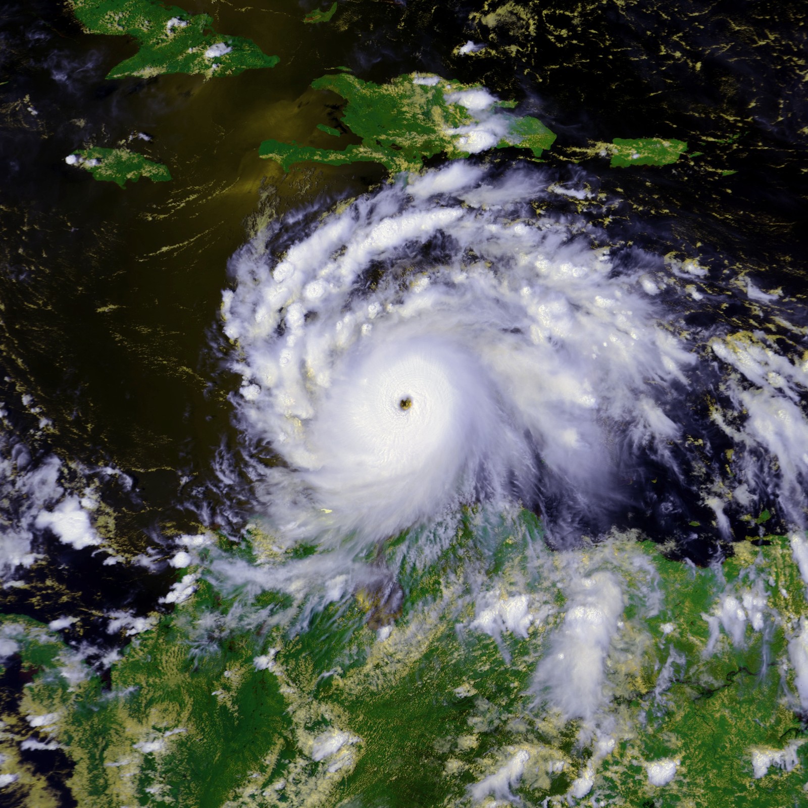
Track=Felix_2007_track.pngAugust 31
Dissipated=September 6
1-min winds=150
Pressure=929August 31 , an area of disturbed weather east of theWindward Islands was numbered Tropical Depression Six after satellite imagery showed that a tropical low had formed.cite web|author=Blake/Avila|date=2007-08-31 |title=Tropical Depression Six Public Advisory One|publisher=National Hurricane Center|accessdate=2007-08-31|url=http://www.nhc.noaa.gov/archive/2007/al06/al062007.public.001.shtml?] Early onSeptember 1 , it was upgraded to a tropical storm and named Felix. Later that day, Felix was upgraded to a hurricane. OnSeptember 2 , Felix was upgraded to a major hurricane. It rapidly intensified into a Category 5 storm by the end of the evening, and after briefly weakening to Category 4 status Felix again restrengthened and struck northeasternNicaragua with winds of 160 mph (260 km/h) onSeptember 4 . (See Impact of Hurricane Felix). It rapidly weakened over land and the last advisory was issued onSeptember 5 . At least 133 people were killed by Hurricane Felix with another 70 others missing.* See the NHC's [http://www.nhc.noaa.gov/archive/2007/FELIX.shtml? advisory archive] on Hurricane Felix.
* See NHC's end-of-season [http://www.nhc.noaa.gov/pdf/TCR-AL062007_Felix.pdf report] on Hurricane Felix.Tropical Storm Gabrielle
Infobox Hurricane Small
Basin=Atl
Track=Gabrielle 2007 track.pngSeptember 8
Dissipated=September 11
1-min winds=50
Pressure=1004cold front that moved off the southeastern coast of the United States onSeptember 1 developed a weak low over the waters near Georgia. The low drifted eastward and weakened over the next few days until it joined with convection from an upper-level trough that had been moving over the western Atlantic.cite web|url=http://www.nhc.noaa.gov/pdf/TCR-AL072007_Gabrielle.pdf|title=Tropical Cyclone Report for Tropical Storm Gabrielle|accessdate=2007-10-30|author=Daniel P. Brown|date=2007-10-29|publisher=National Hurricane Center] An Air Force ReserveHurricane Hunter investigating the low onSeptember 7 was unable to find a well-defined circulation, but did find evidence of tropical storm-force surface winds. Subsequent satellite imagery from that evening discovered a broad and elongated low, indicating that Subtropical Storm Gabrielle had formed about convert|360|nmi|km southeast ofCape Hatteras .cite web|url=http://www.nhc.noaa.gov/archive/2007/al07/al072007.discus.001.shtml?|title=Subtropical Storm Gabrielle Discussion 1|accessdate=2007-10-30|author=Beven/Roberts|date=2007-09-07|publisher=National Hurricane Center]For the next twelve hours, the system's strongest winds and thunderstorms remained well to the north of the center. On
September 8 new convection eventually united with the center, leading the transition of Gabrielle into a tropical storm. Gabrielle gradually strengthened as it travelled northwest towardsNorth Carolina andVirginia . The storm reached its peak intensity of 60 mph (95 km/h) just before it arrived in Cape Lookout, though strong wind shear kept most of the convection and surface winds offshore. Gabrielle weakened over land, and moved back into the Atlantic onSeptember 10 . The circulation deteriorated further, and the storm dissipated southwest ofNova Scotia the next day.cite web|url=http://www.nhc.noaa.gov/archive/2007/al07/al072007.discus.016.shtml?|title=Subtropical Storm Gabrielle Discussion 16|accessdate=2007-10-30|author=Brown|date=2007-09-11|publisher=National Hurricane Center] Damages in eastern North Carolina were very light, and there were no casualties associated with this system.* See the NHC's [http://www.nhc.noaa.gov/archive/2007/GABRIELLE.shtml? advisory archive] on Tropical Storm Gabrielle.
* See NHC's end-of-season [http://www.nhc.noaa.gov/pdf/TCR-AL072007_Gabrielle.pdf report] on Tropical Storm Gabrielle.Tropical Storm Ingrid
Infobox Hurricane Small
Basin=Atl
Track=Ingrid 2007 track.pngSeptember 12
Dissipated=September 17
1-min winds=40
Pressure=1002September 6 . Strong easterly shear inhibited its development until the 9th, when it developed a broad area of low pressure in the mid-tropical Atlantic.cite web|author=National Hurricane Center|year=2007|title=Tropical Cyclone Report for Tropical Storm Ingrid|accessdate=2007-10-18|url=http://www.nhc.noaa.gov/pdf/TCR-AL082007_Ingrid.pdf] By the morning ofSeptember 12 , the shear had weakened, allowing the system to organize into Tropical Depression Eight about convert|980|nmi|km east of theLesser Antilles .The depression moved west-nortwestward for the next week, steering along the southern edge of a mid-tropospheric ridge. Unfavorable conditions caused by moderate westerly shear inhibited the storm's initial development. Despite this, the cyclone slowly developed into a weak tropical storm on
September 13 , and reached its maximum intensity the next day. The shearing winds from a tropical upper tropospheric trough persisted over the cyclone, returning Ingrid to a depression onSeptember 15 . The final advisory was issued on the 17th as the system degenerated into an open wave north of the Leeward Islands.cite web|author=Franklin|year=2007|title=Tropical Storm Ingrid Advisory Twenty|publisher=National Hurricane Center|accessdate=2007-10-18|url=http://www.nhc.noaa.gov/archive/2007/al08/al082007.fstadv.020.shtml?] There were no reports of damage or casualties associated with Ingrid because the storm never threatened land.* See the NHC's [http://www.nhc.noaa.gov/archive/2007/INGRID.shtml? advisory archive] on Tropical Storm Ingrid.
* See NHC's end-of-season [http://www.nhc.noaa.gov/pdf/TCR-AL082007_Ingrid.pdf report] on Tropical Storm Ingrid.Hurricane Humberto
Infobox Hurricane Small
Basin=Atl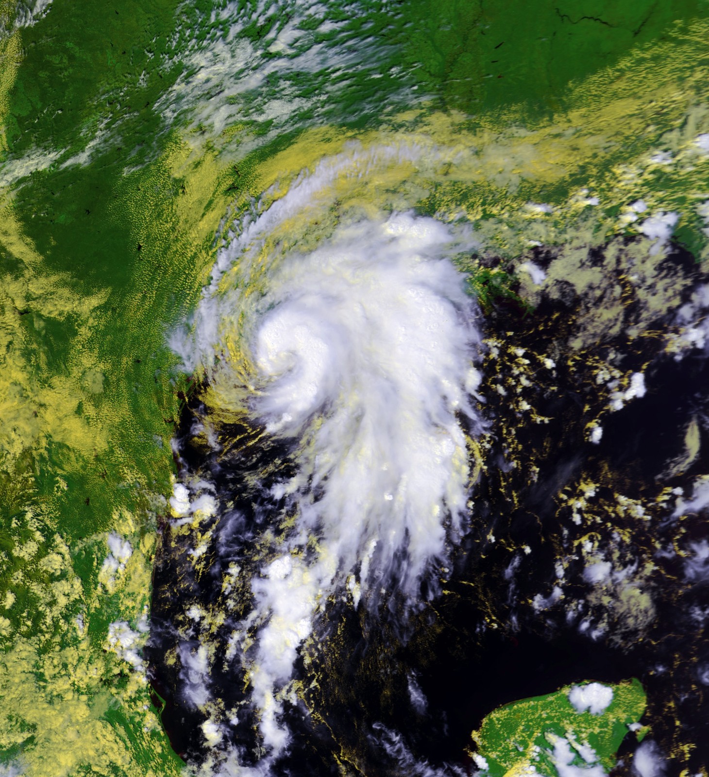
Track=Humberto 2007 track.pngSeptember 12
Dissipated=September 14
1-min winds=80
Pressure=985September 8 , weak surface trough and an upper-level low produced disorganized showers and thunderstorms between westernCuba and the easternGulf of Mexico . [cite web|author=Beven|year=2007|title=September 8 Tropical Weather Outlook|publisher=National Hurricane Center|accessdate=2007-09-12|url=ftp://ftp.met.fsu.edu/pub/weather/tropical/Outlook-A/2007090821.ABNT20] The area of thunderstorms continued to move west-northwestward across the Gulf of Mexico and onSeptember 12 thunderstorms organized enough to be classified as Tropical Depression Nine about 60 miles (100 km) southeast ofMatagorda, Texas . [cite web|author=Rhome|year=2007|title=September 10 Tropical Weather Outlook|publisher=National Hurricane Center|accessdate=2007-09-12|url=ftp://ftp.met.fsu.edu/pub/weather/tropical/Outlook-A/2007091009.ABNT20] cite web|author=Franklin|year=2007|title=Tropical Depression Nine Discussion One|publisher=National Hurricane Center|accessdate=2007-09-12|url=http://www.nhc.noaa.gov/archive/2007/al09/al092007.discus.001.shtml?] The depression quickly intensified, and within three hours of forming, it became Tropical Storm Humberto. [cite web|author=Franklin|year=2007|title=Tropical Storm Humberto Public Advisory One-A|publisher=National Hurricane Center|accessdate=2007-09-12|url=http://www.nhc.noaa.gov/archive/2007/al09/al092007.public_a.001.shtml] Humberto turned to thenorth and eventuallynorth-northeast and continued to rapidly intensify. In the early morning hours ofSeptember 13 ,Hurricane Hunter aircraft found that Humberto had strengthened into a hurricane while located about 15 miles (20 km) off the coast ofTexas . cite web|author=Mainelli & Avila|year=2007|title=Hurricane Humberto Special Discussion Four|publisher=National Hurricane Center|accessdate=2007-09-13|url=http://www.nhc.noaa.gov/archive/2007/al09/al092007.discus.004.shtml?] Around 0700 UTC (3 a.m. CDT), Hurricane Humberto made landfall nearHigh Island, Texas as a category 1 hurricane.cite web|author=Mainelli & Avila|year=2007|title=Hurricane Humberto Discussion Five|publisher=National Hurricane Center|accessdate=2007-09-13|url=http://www.nhc.noaa.gov/archive/2007/al09/al092007.discus.005.shtml?] Humberto quickly weakened and entered SouthwestLouisiana as a tropical storm during the afternoon ofSeptember 13 . cite web|author=Franklin|year=2007|title=Tropical Storm Humberto Discussion Six|publisher=National Hurricane Center|accessdate=2007-09-13|url=http://www.nhc.noaa.gov/archive/2007/al09/al092007.discus.006.shtml?]Hurricane Humberto caused some structural damage on High Island and widespread tree and power line damage in the Beaumont-Port Arthur area.cite news | first = Beth | last = Gallaspy | coauthors= | title = Hurricane Humberto hammers SE Texas, kills Bridge City man | date =
2007-09-13 | publisher = Beaumont Enterprise| url = http://www.beaumontenterprise.com/site/news.cfm?newsid=18812791&BRD=2287&PAG=461&dept_id=512588&rfi=6 | work = The Beaumont Enterprise | accessdate = 2007-09-13 | language = English] Power outages caused four oil refineries to halt production in Beaumont. One person was reported dead as a result of the storm, a Bridge City man killed when his carport crashed on him outside his house. Damage was estimated at $50 million.* See the NHC's [http://www.nhc.noaa.gov/archive/2007/HUMBERTO.shtml? advisory archive] on Hurricane Humberto.
* See the HPC's [http://www.hpc.ncep.noaa.gov/tropical/HUMBERTO/HUMBERTO_archive.shtml advisory archive] on Tropical Depression Humberto.
* See NHC's end-of-season [http://www.nhc.noaa.gov/pdf/TCR-AL092007_Humberto.pdf report] on Hurricane Humberto.Tropical Depression Ten
Infobox Hurricane Small
Basin=Atl
Track=10-L 2007 track.pngSeptember 21
Dissipated=September 22
1-min winds=30
Pressure=1005Florida onSeptember 18 . It slowly tracked westward, breaking itself away from a trough over the Atlantic while crossing the Florida Peninsula onSeptember 19 , emerging in theGulf of Mexico onSeptember 20 . It slowly organized itself and was classified as a subtropical depression on the morning ofSeptember 21 just south of theFlorida Panhandle . Three hours later, it was reclassified as fully tropical. At 8 pm EDT (0000 UTC) later that day, Tropical Depression Ten began to move onshore, and never reached tropical storm strength.Damage from the precursor low was reported in
Eustis, Florida from one or moretornado es that damaged or destroyed about 50 houses, but caused no serious injuries. [ [http://www.orlandosentinel.com/news/local/lake/orl-bk-tornadowarning092007,0,1891646.story?track=rss Topic Galleries - OrlandoSentinel.com ] ] No deaths were reported from the tornado, and damage totaled $6.2 million.* See the NHC's [http://www.nhc.noaa.gov/archive/2007/TEN.shtml? advisory archive] on Tropical Depression Ten.
* See NHC's end-of-season [http://www.nhc.noaa.gov/pdf/TCR-AL102007_Ten.pdf report] on Tropical Depression Ten.Tropical Storm Jerry
Infobox Hurricane Small
Basin=Atl
Track=Jerry 2007 track.pngSeptember 23
Dissipated=September 24
1-min winds=35
Pressure=1003low pressure area over the central Atlantic onSeptember 21 . Late the next day, it had been determined that a subtropical depression had formed, as a warm core had developed but the system was still involved with an upper-level low, and its strongest winds were well removed from the center.cite web|url=http://www.nhc.noaa.gov/pdf/TCR-AL112007_Jerry.pdf|title=Tropical Cyclone Report for Tropical Storm Jerry|accessdate=2007-11-09|author=Lixion A. Avila|date=2007-10-24|publisher=National Hurricane Center] Early onSeptember 23 , bothsatellite estimates andQuikScat data determined that the depression had strengthened into Subtropical Storm Jerry, despite the lack of a well-defined inner core.cite web|url=http://www.nhc.noaa.gov/archive/2007/al11/al112007.discus.002.shtml?|title=Subtropical Storm Jerry Discussion #2|accessdate=2007-11-09|author=Pasch|date=2007-09-23|publisher=National Hurricane Center] The storm became fully tropical that evening as a weak and sheared tropical storm with 40 mph (65 km/h) winds over a small radius.cite web|url=http://www.nhc.noaa.gov/archive/2007/al11/al112007.discus.004.shtml?|title=Tropical Storm Jerry Discussion #4|accessdate=2007-11-09|author=Brown|date=2007-09-23|publisher=National Hurricane Center] It remained a tropical storm untilSeptember 24 , when it weakened to a tropical depression ahead of a powerfulcold front with little deep convection remaining in the system.cite web|url=http://www.nhc.noaa.gov/archive/2007/al11/al112007.discus.006.shtml?|title=Tropical Depression Jerry Discussion #6|accessdate=2007-11-09|author=Pasch|date=2007-09-24|publisher=National Hurricane Center] It completely dissipated by early onSeptember 25 . Jerry never approached land during its lifespan, and no damage or casualties were reported. No ships were impacted by Jerry.* See the NHC's [http://www.nhc.noaa.gov/archive/2007/JERRY.shtml? archive history] on Tropical Storm Jerry.
* See NHC's end-of-season [http://www.nhc.noaa.gov/pdf/TCR-AL112007_Jerry.pdf report] on Tropical Storm Jerry.Hurricane Karen
Infobox Hurricane Small
Basin=Atl
Track=Karen 2007 track.pngSeptember 25
Dissipated=September 29
1-min winds=65
Pressure=988Africa onSeptember 21 . As it moved westward, deep convection gradually increased over the disturbance as its broad low-level circulation became better-defined. BySeptember 24 , as the system traveled northwestward it organized enough to become a tropical depression.cite web|url=http://www.nhc.noaa.gov/pdf/TCR-AL152007_Fifteen.pdf|title=Tropical Cyclone Report for Hurricane Karen|accessdate=2007-11-27|author=Richard J. Pasch|date=2007-11-21|publisher=National Hurricane Center] Six hours later the depression was upgraded to Tropical Storm Karen.cite web|url=http://www.nhc.noaa.gov/archive/2007/al12/al122007.discus.002.shtml?|title=Tropical Storm Karen Discussion 2|accessdate=2007-11-27|author=Bevin|date=2007-09-25|publisher=National Hurricane Center]Karen's organization and intensity remained steady for the next day. Early on the 26th, however, the storm strengthened significantly. In post-operational analysis the cyclone was determined to have reached hurricane-strength for about twelve hours. The strengthening was short-lived because a sharp upper-level trough to the west of Karen increased the amount of vertical
wind shear over the hurricane. BySeptember 28 these unfavorable conditions had weakened Karen to a marginal tropical storm and left its low-level circulation exposed.cite web|url=http://www.nhc.noaa.gov/archive/2007/al12/al122007.discus.014.shtml?|title=Tropical Storm Karen Discussion 14|accessdate=2007-11-27|author=Mainelli|date=2007-09-28|publisher=National Hurricane Center] Meanwhile, the storm began heading northward and experiencing intermittent bursts of deep convection. However, the relentless wind shear exposed the system's circulation until it dissipated in the mid-Atlantic onSeptember 29 . Karen's remnants lingered near theLeeward Islands for the next few days, although the system never directly affected land. As a result, no reported damages or casualties were associated with Karen.* See the NHC's [http://www.nhc.noaa.gov/archive/2007/KAREN.shtml? archive history] on Hurricane Karen.
* See NHC's end-of-season [http://www.nhc.noaa.gov/pdf/TCR-AL122007_Karen.pdf report] on Hurricane Karen.Hurricane Lorenzo
Infobox Hurricane Small
Basin=Atl
Track=Lorenzo 2007 track.pngSeptember 25
Dissipated=September 28
1-min winds=70
Pressure=990tropical wave moved off the western coast ofAfrica onSeptember 11 ,cite web|author=National Hurricane Center|year=2007|title=Tropical Cyclone Report for Hurricane Lorenzo|accessdate=2007-10-19|url=http://www.nhc.noaa.gov/pdf/TCR-AL132007_Lorenzo.pdf] traversed the Caribbean and crossed the Yucatán onSeptember 21 . The disturbance developed a small surface low on the 24th while moving erratically over the southwestern Gulf of Mexico. Strong upper-level winds initially prevented the system from developing convection; however, it relaxed on the following day and convection increased.cite web|author=Franklin and Brown|year=2007|title=September 24 5:30 p.m. Tropical Weather Outlook|publisher=National Hurricane Center|accessdate=2007-09-26|url=http://www.nhc.noaa.gov/archive/text/TWOAT/TWOAT.200709242124.txt] On theevening ofSeptember 25 , a Hurricane Hunter aircraft found evidence that the low qualified as a tropical depression.cite web|author=Franklin|year=2007|title=Tropical Depression Thirteen Discussion 1|publisher=National Hurricane Center|accessdate=2007-09-26|url=http://www.nhc.noaa.gov/archive/2007/al13/al132007.discus.001.shtml?]Under weak steering currents, the depression drifted south and southwest, executing a small cyclonic loop into the
Bay of Campeche . Upper-level winds gave way to an anticyclone above the depression, and the system became a Tropical Storm Lorenzo onSeptember 27 about convert|130|nmi|km east ofTuxpan . Rapid intensification brought Lorenzo to hurricane status early that evening, less than twelve hours after becoming a tropical storm. Lorenzo reached its peak intensity onSeptember 28 , then weakened slightly before making landfall nearTecolutla, Mexico as a minimal hurricane. The small circulation weakened rapidly after landfall, and the system dissipated the next day.Six deaths in
Mexico were attributable to Lorenzo; mostly attributable to flash floods and mudslides. The states ofPuebla andVeracruz reported damage from rain and high winds. Two hundred people were forced to evacuate inHidalgo when theSan Lorenzo River overflowed its banks. Lorenzo made landfall in virtually the same location that Hurricane Dean had struck a month earlier.* See the NHC's [http://www.nhc.noaa.gov/archive/2007/LORENZO.shtml? advisory archive] on Hurricane Lorenzo.
* See NHC's end-of-season [http://www.nhc.noaa.gov/pdf/TCR-AL132007_Lorenzo.pdf report] on Hurricane Lorenzo.Tropical Storm Melissa
Infobox Hurricane Small
Basin=Atl
Track=Melissa 2007 track.pngSeptember 28
Dissipated=September 30
1-min winds=35
Pressure=1005September 26 . The next day an area of low pressure developed near theCape Verde islands, and the system soon organized into Tropical Depression Fourteen onSeptember 28 .cite web|url=http://www.nhc.noaa.gov/archive/2007/al14/al142007.discus.001.shtml?|title=Tropical Depression Fourteen Discussion 1|accessdate=2007-09-29|author=Avila|date=2007-09-28|publisher=National Hurricane Center] The depression drifted westward between very weak steering currents. Ordinarily a system would be steered along the edge of a subtropical ridge, but a low pressure system over the northeastern Atlantic subdued its development.cite web|url=http://www.nhc.noaa.gov/pdf/TCR-AL142007_Melissa.pdf|title=Tropical Cyclone Report for Tropical Storm Melissa|accessdate=2007-10-23|author=Richard D. Knabb|date=2007-10-13|publisher=National Hurricane Center]While inching westward, the depression strengthened slightly and became Tropical Storm Melissa on
September 29 , tying the record for most tropical storms to form in a month.cite web|url=http://www.nhc.noaa.gov/archive/2007/tws/MIATWSAT_sep.shtml?|title=Tropical Weather Summary - September 2007|accessdate=2007-11-12|author=Mainelli et al|date=2007-10-01|publisher=National Hurricane Center] The next day increasing westerly shear weakened Melissa back to a tropical depression. As it lost deep convection, the depression moved rapidly toward the west-northwest along the southern edge of a regenerating low-level ridge. Thunderstorm activity sputtered, and the depression degenerated to a remnant low on the 30th about convert|475|nmi|km west of the Cape Verde Islands. The low tracked along the low-level ridge for the several days, and merged with a frontal zone northeast of theLeeward Islands onOctober 5 . Since Melissa did not affect land, there were no reports of damage or casualties associated with the storm.* See the NHC's [http://www.nhc.noaa.gov/archive/2007/MELISSA.shtml? archive history] on Tropical Storm Melissa.
* See NHC's end-of-season [http://www.nhc.noaa.gov/pdf/TCR-AL142007_Melissa.pdf report] on Tropical Storm Melissa.Tropical Depression Fifteen
Infobox Hurricane Small
Basin=Atl
Track=15-L 2007 track.pngOctober 11
Dissipated=October 12
1-min winds=30
Pressure=1011Caribbean Sea into the western Atlantic. OnOctober 8 the eastern end of the system formed a surface low and gradually developed convection as it moved northeastward. It is possible that the system's formation was helped by the remains of Hurricane Karen.cite web|url=http://www.nhc.noaa.gov/pdf/TCR-AL152007_Fifteen.pdf|title=Tropical Cyclone Report for Tropical Depression Fifteen|accessdate=2007-11-26|author=Jack Bevin|date=2007-11-22|publisher=National Hurricane Center] While convert|645|nmi|km|abbr=on southeast ofBermuda the system was sufficiently organized to declare it a tropical depression onOctober 11 . The depression maintained its intensity while an upper-level trough moved through the area. In its wake the cyclone was left with hostile conditions, including strong northerly wind shear.cite web|url=http://www.nhc.noaa.gov/archive/2007/al15/al152007.discus.003.shtml?|title=Tropical Depression Fifteen Discussion 1|accessdate=2007-11-26|author=Bevin|date=2007-10-12|publisher=National Hurricane Center] The depression weakened to a remnant low onOctober 12 and merged with a frontal zone two days later. The resulting extratropical low strengthened slightly until it was absorbed by a larger extratropical system north of theAzores onOctober 17 . Because the system remained far from land, no damages were reported.* See the NHC's [http://www.nhc.noaa.gov/archive/2007/FIFTEEN.shtml? advisory archive] on Tropical Depression Fifteen.
* See NHC's end-of-season [http://www.nhc.noaa.gov/pdf/TCR-AL152007_Fifteen.pdf report] on Tropical Depression Fifteen.Hurricane Noel
Infobox Hurricane Small
Basin=Atl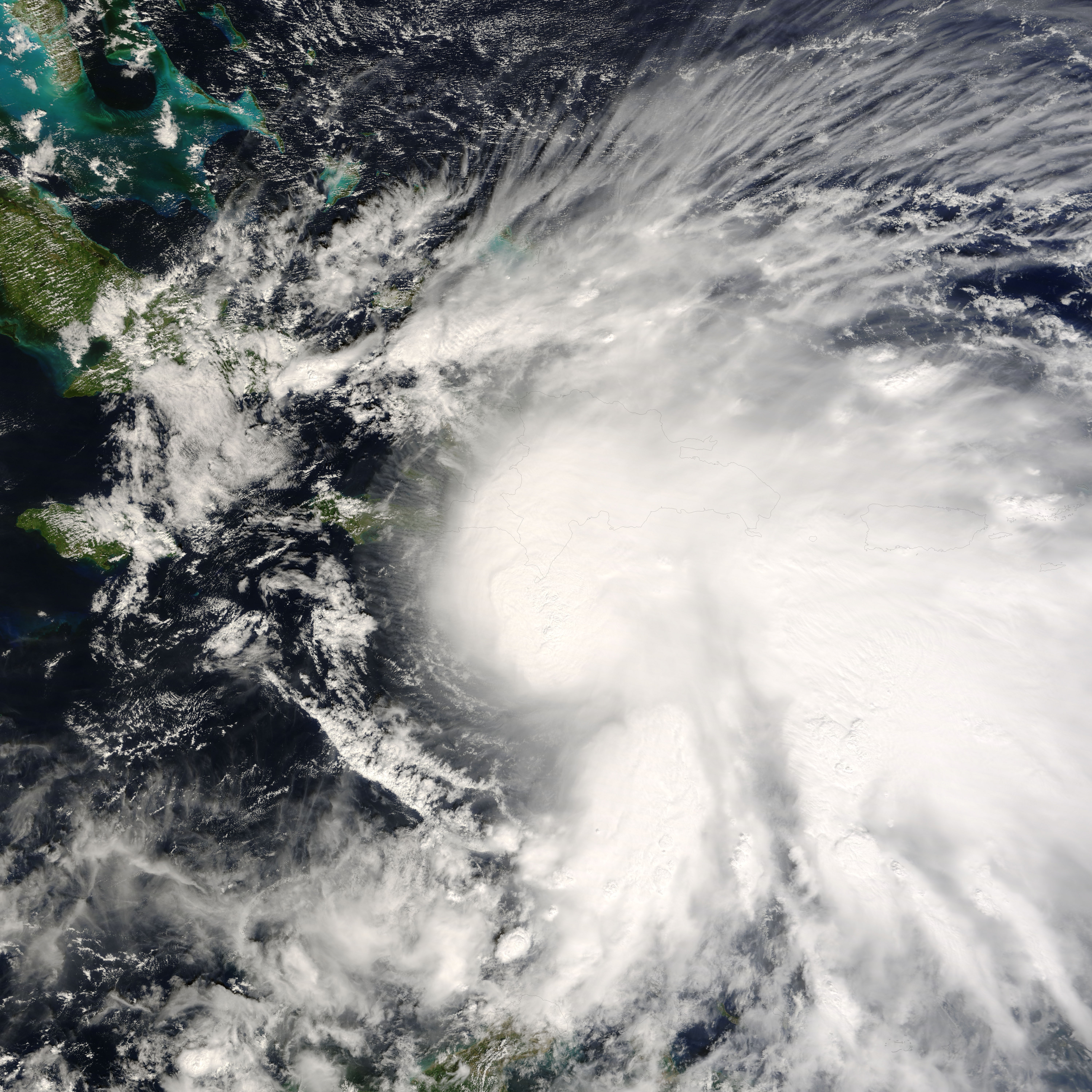
Track=Noel 2007 track.pngOctober 28
Dissipated=November 2
1-min winds=70
Pressure=980October 27 , a low pressure system that had been slowly developing over the eastern Caribbean gained enough organization to be declared Tropical Depression Sixteen. It steadily intensified and became a tropical storm on the afternoon ofOctober 28 . It made landfall inHaiti onOctober 29 , and then meandered across the westernCaribbean nearCuba for the next three days. Noel brought torrential rain to the region, killing at least 168 people. It then accelerated northeastward, passing through the Bahamas before strengthening to a hurricane onNovember 1 . Noel began an extratropical transition onNovember 2 . While sustained winds were still at Category 1 strength, the NHC issued its final advisory that afternoon. TheCanadian Hurricane Centre issued ongoing advisories every three hours on Post-tropical Storm Noel as it approached Canada's eastern provinces until it completed its transition to being fully extratropical onNovember 4 while overLabrador , shortly before it crossed back into the Atlantic, heading towards West Greenland.* See the NHC's [http://www.nhc.noaa.gov/archive/2007/NOEL.shtml advisory archive] on Hurricane Noel.
* See the NHC's end-of-season [http://www.nhc.noaa.gov/pdf/TCR-AL162007_Noel.pdf report] on Hurricane Noel.Tropical Storm Olga
Infobox Hurricane Small
Basin=Atl
Track=Olga 2007 track.pngDecember 11
Dissipated=December 13
1-min winds=50
Pressure=1003Lesser Antilles . It slowly acquired subtropical characteristics, and late onDecember 10 , the NHC declared it Subtropical Storm Olga while just north ofPuerto Rico . It is the first post-season storm since Tropical Storm Zeta in the 2005 season, making this season one of the few with activity both before and after the official bounds of the hurricane season. The storm made landfall onDecember 11 on the eastern tip of theDominican Republic . Later that evening, Olga transitioned into a tropical storm just after making landfall. Further weakening took place and the storm degenerated into a remnant low late onDecember 12 .Flooding and mudslides caused at least 40 deaths - one in Puerto Rico, two in
Haiti and at least 37 in the Dominican Republic. [http://www.nhc.noaa.gov/pdf/AL172007-Olga.pdf]* See the NHC's [http://www.nhc.noaa.gov/archive/2007/OLGA.shtml advisory archive] on Tropical Storm Olga.
* See the NHC's end-of-season [http://www.nhc.noaa.gov/pdf/TCR-AL172007_Olga.pdf report] on Tropical Storm Olga.Retirement
Hurricanes Dean, Felix, and Noel were retired by the
World Meteorological Organization onMay 13 ,2008 at the 30th Session of the World Meteorological Organization's Regional Association IV Hurricane Committee during its annual meeting in Orlando,Florida . The names were replaced with Dorian, Fernand, and Nestor. [cite web|url = http://www.noaanews.noaa.gov/stories2008/20080513_stormnames.html|title = Dean, Felix and Noel "Retired" from List of Storm Names|accessmonthday =May 13 |accessyear = 2008|date =May 13 ,2008 |publisher = NOAA]ee also
*
List of Atlantic hurricanes
*List of storms in the 2006 Atlantic hurricane season References
External links
* [http://www.nhc.noaa.gov National Hurricane Center Website]
Wikimedia Foundation. 2010.