- Cothelstone
-
Coordinates: 51°04′37″N 3°09′53″W / 51.0770°N 3.1647°W
Cothelstone 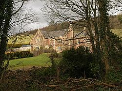
Vicarage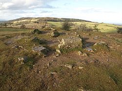
Summit of Cothelstone Hill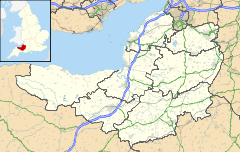
 Cothelstone
Cothelstone shown within SomersetPopulation 111 [1] OS grid reference ST185315 District Taunton Deane Shire county Somerset Region South West Country England Sovereign state United Kingdom Post town TAUNTON Postcode district TA4 Dialling code 01823 Police Avon and Somerset Fire Devon and Somerset Ambulance South Western EU Parliament South West England UK Parliament Taunton Deane List of places: UK • England • Somerset Cothelstone is a village and civil parish in Somerset, England, situated in the Quantock Hills six miles north of Taunton in the Taunton Deane district. The parish, which includes the hamlet of Toulton, has a population of 111.[1]
The view from Cothelstone with a telescope on a fine day is said to include 14 counties and 150 churches.[2]
Contents
History
The manor of Cothelstone was given to the Stawell family after the Norman conquest of England in 1066.[2] The parish of Cothelstone was part of the Taunton Deane Hundred.[3]
During the English Civil War, Sir John Stawell of Cothelstone had raised a small force at his own expense to defend the King. When Taunton fell to parliamentary troops and was held by Robert Blake he attacked Stawell at Bishops Lydeard and imprisoned him. After the restoration, Charles II conferred the title of Baron Stawell on Sir John's son, Ralph.[2]
Governance
The parish council has responsibility for local issues, including setting an annual precept (local rate) to cover the council’s operating costs and producing annual accounts for public scrutiny. The parish council evaluates local planning applications and works with the local police, district council officers, and neighbourhood watch groups on matters of crime, security, and traffic. The parish council's role also includes initiating projects for the maintenance and repair of parish facilities, as well as consulting with the district council on the maintenance, repair, and improvement of highways, drainage, footpaths, public transport, and street cleaning. Conservation matters (including trees and listed buildings) and environmental issues are also the responsibility of the council.
The village falls within the Non-metropolitan district of Taunton Deane, which was formed on April 1, 1974 under the Local Government Act 1972, having previously been part of Taunton Rural District.[4] The district council is responsible for local planning and building control, local roads, council housing, environmental health, markets and fairs, refuse collection and recycling, cemeteries and crematoria, leisure services, parks, and tourism.
Somerset County Council is responsible for running the largest and most expensive local services such as education, social services, libraries, main roads, public transport, policing and fire services, trading standards, waste disposal and strategic planning.
It is also part of the Taunton Deane county constituency represented in the House of Commons of the Parliament of the United Kingdom. It elects one Member of Parliament (MP) by the first past the post system of election, and part of the South West England constituency of the European Parliament which elects seven MEPs using the d'Hondt method of party-list proportional representation.
Landmarks
Cothelstone Manor was built in the mid 16th century, largely demolished by the parliamentary troops in 1646 and rebuilt by E.J. Esdaile in 1855–56.[5] The 16th-century gatehouse[6] and gazebo[7] and 17th-century Banqueting Hall have survived.[8]
The nearby St Agnes' Well is a Grade II* Well house dating from the Medieval period and restored in the nineteenth century. It is constructed of coursed red sandstone masonry with corbel roof. Its water is accessed via an arched doorway behind which is a large volume of clear shallow water. The water is also piped off for farm use. It has a varied folklore, noted as being a healing well, a wishing well of considerable power, an aid to fertility, and virgins used divinations to 'discover' their future husbands on the eve of St Agnes's feast day. It is currently undergoing further restoration.[9][10][11]
Religious sites
The red sandstone Church of St Thomas of Canterbury dates from the 12th century and was largely restored in 1864. It includes memorials to the Stawell family including: Sir Matthew de Stawell, died 1379, and his wife Elizabeth, and John Stawell, died 1603. The church has been designated by English Heritage as a Grade I listed building.[12]
References
- ^ a b "Taunton Deane 2002 parish population estimates". Somerset County Council. http://www.webcitation.org/5lRyCZwqu. Retrieved 27 December 2009.
- ^ a b c Waite, Vincent (1964). Portrait of the Quantocks. London: Robert Hale. ISBN 0709111584.
- ^ "Somerset Hundreds". GENUKI. http://www.genuki.org.uk/big/eng/SOM/Miscellaneous/. Retrieved 21 October 2011.
- ^ A Vision of Britain Through Time : Taunton Rural District
- ^ "Cothelstone Manor". Images of England. http://www.imagesofengland.org.uk/Details/Default.aspx?id=270297. Retrieved 2008-03-09.
- ^ "Gatehouse". Images of England. http://www.imagesofengland.org.uk/Details/Default.aspx?id=270296. Retrieved 2008-03-09.
- ^ "Gazebo". Images of England. http://www.imagesofengland.org.uk/Details/Default.aspx?id=270298. Retrieved 2008-03-09.
- ^ "Banqueting Hall". Images of England. http://www.imagesofengland.org.uk/Details/Default.aspx?id=270301. Retrieved 2008-03-09.
- ^ "St Agnes' Well". Images of England. English Heritage. http://www.imagesofengland.org.uk/Details/Default.aspx?id=270303&mode=adv. Retrieved 2008-11-03.
- ^ "St. Agnes Well — Holy Well or Sacred Spring". The Megalithic Portal. http://www.megalithic.co.uk/article.php?sid=15299. Retrieved 2008-11-03.
- ^ "Holy well based at Cothelstone". http://wellobsessed.com/page3.htm. Retrieved 2008-11-03.
- ^ "Church of St Thomas of Canterbury". Images of England. http://www.imagesofengland.org.uk/Details/Default.aspx?id=270300. Retrieved 2008-03-09.
External links
 Media related to Cothelstone at Wikimedia Commons
Towns, villages and hamlets in the Taunton Deane borough of Somerset, England 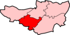 Ashbrittle · Ash Priors · Bathealton · Bickenhall · Bishop's Hull · Bishops Lydeard · Bradford on Tone · Burrowbridge · Cheddon Fitzpaine · Chipstable · Churchstanton · Combe Florey · Comeytrowe · Corfe · Cotford St Luke · Cothelstone · Creech St Michael · Curland · Durston · Fitzhead · Halse · Hatch Beauchamp · Kingston St Mary · Langford Budville · Lydeard St Lawrence · Milverton · North Curry · Norton Fitzwarren · Nynehead · Oake · Orchard Portman · Otterford · Pitminster · Ruishton · Sampford Arundel · Staple Fitzpaine · Stawley · Stoke St Gregory · Stoke St Mary · Taunton · Thornfalcon · Tolland · Trull · Wellington · Wellington Without · West Bagborough · West Buckland · West Hatch · West Monkton · WiveliscombeCategories:
- Villages in Taunton Deane
- Civil parishes in Somerset


Wikimedia Foundation. 2010.