- Coyote Buttes
-
 The Magic Crest of South Coyote Buttes.
Coyote Buttes is a section of the Paria Canyon-Vermilion Cliffs Wilderness managed by the Bureau of Land Management (BLM), spanning extreme South Central Utah and North Central Arizona, just south of US 89 halfway between Kanab, Utah and Page, Arizona. It is divided into two areas: Coyote Buttes North and Coyote Buttes South. Visiting either of the Coyote Buttes areas requires purchasing a hiking permit in advance. Only 20 people per day are allowed to hike in. The BLM Website explains how to obtain a permit.
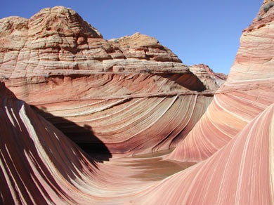
One of the highlights of Coyote Buttes North Area is the spectacular rock formation known simply as The Wave, an incredible sandstone formation which has been photographed countless times, and the Second Wave, another fabulous sandstone swirl.
The Wave and Buckskin Gulch share the Wire Pass Trailhead on House Rock Valley Road.
Gallery
-

Coyote Buttes -

Coyote Buttes -

The Wave
 Panorama, Brain Rock Garden, Coyote Buttes
External links
Coordinates: 36°58′04″N 112°00′41″W / 36.96778°N 112.01139°WCategories:- Buttes of the United States
- Rock formations in Utah
- Rock formations in Arizona
- Mountains of Utah
- Mountains of Arizona
- Landforms of Coconino County, Arizona
- Landforms of Kane County, Utah
- Kanab, Utah
- Bureau of Land Management areas in Utah
- Protected areas of Coconino County, Arizona
- Protected areas of Kane County, Utah
- Utah geography stubs
- Arizona geography stubs
-


Wikimedia Foundation. 2010.