Mount Adelung

Mount Adelung
Adelung
гора Аделунга, Adelunga Toghi
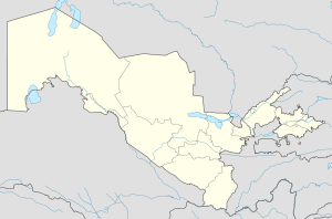
Adelung is located in Uzbekistan
Adelung
Location in Uzbekistan
Coordinates: 42°07′N 70°58′E / 42.117°N 70.967°E / 42.117; 70.967
Country Flag of Uzbekistan.svg Uzbekistan
Province Tashkent Province
Elevation 4,301 m (14,111 ft)
Mt. Adelung is the highest point in Tashkent Province, but NOT the highest point in Uzbekistan.

Mount Adelung (Russian: Гора Аделунга) is the highest peak in Pskem Range (Russian: Пскемский хребет) in the extreme north-east of the Tashkent Province, Uzbekistan.[1] Mount Adelung is 4,301 meters high, just 2 meters higher than the nearby Mount Beshtor, located a little further to the south-west in the same range, and it is often erroneously identified in various web sources as the "highest point in Uzbekistan". In fact, this honor goes to the Khazret Sultan, a peak with an altitude of 4,643 m in Surkhandarya Province, in the Uzbek part of the Gissar Range, on the border with Tajikistan, which was formerly known as Peak of the 22nd Congress of the Communist Party.[2][3]

Some web sources use the name Adelunga Toghi, where Adelunga corresponds to the Russian possessive form of Adelung and Toghi presumably stands for mountain in the Uzbek language (tog’ in Latin script, тоғ in Cyrillic script). It is not known at this stage of writing which Adelung the mountain is named after.

References

  1. ^ Physical map of Tashkent Province, Uzgeodezkadastr, Tashkent, 2002 (low resolution)
  2. ^ Atlas of the Soviet Central Asian Republics, Geodesy and Cartography Authority, Moscow, 1988, in Russian.
  3. ^ Administrative map of the Republic of Uzbekistan, State Committee of Land Resources, Geodesy, Cartography, and State Cadastre, Tashkent, 2007.

Coordinates: 42°07′N 70°58′E / 42.117°N 70.967°E / 42.117; 70.967


Wikimedia Foundation. 2010.

Игры ⚽ Поможем решить контрольную работу

Look at other dictionaries:

  • Mount Beshtor — Beshtor гора Бештор, гора Беш Тёр …   Wikipedia

  • Pskem Range — ( ru. Пскемский хребет) extends over 120 km from north east to south west in the extreme north eastern finger of Uzbekistan s Tashkent Province. The range is a water divide between Pskem River to the north and the rivers Sandalysh, Chatkal, and… …   Wikipedia

  • Пскемский хребет — Пскемский хребет …   Википедия

  • Kartouwe — exhibit in Königstein Fortress (Germany) Half kartouwe exhibit in Ma …   Wikipedia

  • Lord's Prayer — For alternative meanings, see: Lord s Prayer (disambiguation), Our Father (disambiguation), and Pater Noster (disambiguation). The Sermon on the Mount by Carl Heinrich Bloch The Lord s Prayer (also called the Pater Noster[1] …   Wikipedia

  • Macedonian language — This article is about the modern Slavic language. For the extinct Paleo Balkan language, see Ancient Macedonian language. For other uses, see Macedonian (disambiguation). Macedonian Македонски јазик Makedonski jazik Pronunciation …   Wikipedia

  • Californien [1] — Californien, 1) (Geogr. u. Statistik). A) Alt od. Nieder C. (California la vieja), Gebiet der nordamerikanischen Republik Mexiko, eine schmale, sich von N. (32°28 u. Br.) nach S. (Cap San Lucas 22°52 u. Br.) erstreckende, 390 Ml. lange u. 11–43… …   Pierer's Universal-Lexikon

  • Liste der Söhne und Töchter der Stadt Bremen — Die folgende Übersicht enthält bedeutende in Bremen geborene Persönlichkeiten, unabhängig von ihrem späteren Wirkungskreis. Unter dem Abschnitt Sonstige Persönlichkeiten werden einige Personen genannt, die in Bremen wirkten, aber anderenorts… …   Deutsch Wikipedia

Share the article and excerpts

Direct link
Do a right-click on the link above
and select “Copy Link”