- County Laois
-
County Laois
Contae Laoise
Coat of armsMotto: I bpáirt leis an bpobal (Irish)
"In partnership with the community"
Country Ireland Province Leinster Dáil Éireann Laois-Offaly EU Parliament East County seat Portlaoise Government – Type County Council Area – Total 1,720 km2 (664.1 sq mi) Area rank 23rd Population (2011) 80,458 – Rank 23rd Car plates LS Website laois.ie County Laois (
 /ˈliːʃ/ "leash"; Irish: Contae Laoise) is a county in Ireland. It is part of the Midlands Region and is also located in the province of Leinster. It was formerly known as Queen's County (Irish: Contae na Banríona) until the establishment of the Irish Free State in 1922. The county's name was formerly spelt as Laoighis and Leix. Laois County Council is the local authority for the county. The population of the county is 80,458 according to the 2011 census - 20% higher than it was in the 2006 census which is the highest percentage population growth in the country.
Contents
Geography and political subdivisions
Laois is the 23rd largest of Ireland’s 32 counties in area and 24th largest in terms of population.[1] It is the seventh largest of Leinster’s 12 counties in size and tenth largest in terms of population. The county is landlocked and,uniquely, does not border any other county which touches the coast. It is therefore considered to be "the most landlocked county in Ireland."[2], although County Roscommon is the geographical centre of Ireland.
Towns and villages
 Countryside south of Portlaoise.
- Abbeyleix
- Aghaboe
- Arles
- Ballacolla
- Ballaghmore
- Ballickmoyler
- Ballinakill
- Ballybrittas
- Ballybrophy
- Ballyhide
- Ballyfin
- Ballylinan
- Ballyroan
- Barrowhouse
- Borris-in-Ossory
- Castletown
- Clonaslee
- Cullohill
- Donaghmore
- Durrow
- Emo
- Errill
- Graiguecullen , County Laois
- Jamestown
- Killeshin
- Mountmellick
- Mountrath
- Newtown
- Portarlington
- Portlaoise
- Rathdowney
- Rosenallis
- Shanahoe
- Stradbally
- The Swan
- Timahoe
- Vicarstown
Climate
A new weather station broadcasts from Durrow providing real time data.[3] The station was set up in May 2008. It is a Davis ProVantage 2 station and monitors temperature, rain, wind, wind direction, humidity and atmospheric pressure.
History
Historical populations Year Pop. ±% 1653 9,915 — 1659 11,115 +12.1% 1821 134,275 +1108.1% 1831 145,851 +8.6% 1841 153,930 +5.5% 1851 111,664 −27.5% 1861 90,650 −18.8% 1871 79,771 −12.0% 1881 73,124 −8.3% 1891 64,883 −11.3% 1901 57,417 −11.5% 1911 54,629 −4.9% 1926 51,540 −5.7% 1936 50,109 −2.8% 1946 49,697 −0.8% 1951 48,430 −2.5% 1956 47,087 −2.8% 1961 45,069 −4.3% 1966 44,595 −1.1% 1971 45,259 +1.5% 1979 49,936 +10.3% 1981 51,171 +2.5% 1986 53,284 +4.1% 1991 52,314 −1.8% 1996 52,945 +1.2% 2002 58,774 +11.0% 2006 67,059 +14.1% 2011 80,458 +20.0% [4][5][6][7][8][9] Prehistoric
The first people in Laois were bands of hunters and gatherers who passed through the county about 8,500 years ago. They hunted in the forests that covered Laois and fished in its rivers, gathering nuts and berries to supplement their diets.
Next came Ireland’s first farmers. These people of the Neolithic period (4000 to 2500 BC) cleared forests and planted crops. Their burial mounds remain in Clonaslee and Cuffsborough.
Around 2500 BC, the people of the Bronze Age lived in Laois. They produced weapons, tools and golden objects. Visitors to the county can see a stone circle they left behind at Monamonry, as well as the remains of their hill forts at Clopook and Monelly. Skirk, near Borris-in-Ossory, has a Bronze Age standing stone and ring fort.
In ancient times the O'Moore tribe name of Ui Laoighis was applied to their territory, this name being derived from a famous Ulster ancestor named Lughaid Laoighesach, descendant of a renowned Conall Cearmach chief of the Red Branch Knights of Ulster.
The next stage is known as the pre-Christian Celtic Iron Age. For the first time iron appeared in Ireland, as factions fought bloody battles for control of the land. At Ballydavis, archaeologists have discovered ring barrows that date from this time period.
By the first century AD, Laois was part of the Kingdom of Ossory. The county was divided roughly into seven parts, which were ruled by the Seven Septs of Laois: O’More (O’Moore), O’Lalor, O’Doran, O’Dowling, O’Devoy (O’Deevy), O’Kelly and McEvoy.
Introduction of Christianity
When Christianity came to Ireland, holy men and women founded religious communities in Laois. Between 550 and 600, St. Canice founded Aghaboe Abbey and St. Mochua founded a religious community at Timahoe. An early Christian community lived at Dun Masc or Masc’s fort, on the Rock of Dunamase.
The Synod of Rathbreasail that established the Irish dioceses was held near Mountrath in 1111, moving the Church away from its monastic base. As religious orders with strong ties to Rome replaced older religious communities, the wooden buildings of the early Christian churches in Laois gave way to stone monasteries. The Augustinians and Dominicans established themselves at Aghaboe Abbey, while the Cistercians took over an older religious community at Abbeyleix.
Norman Invasion
The Norman invasion of Ireland in 1169-71 affected Laois as it was a part of the Kingdom of Leinster. In Laois, the fortress on the Rock of Dunamase was part of the dowry of the Irish princess Aoife, who was given in marriage in 1170 to the Norman warrior Strongbow. Advancing Normans surveyed the county from wooden towers built on top of earthen mounds, known as mottes. They also built stone fortresses, such as Lea Castle, just outside Portarlington. Several of the county’s towns were first established as Norman boroughs, including Castletown, Durrow and Timahoe.
From 1175 until about 1325, Normans controlled the best land in the county, while Gaelic society retreated to the bogs, forests and the Slieve Bloom Mountains. The early 14th century saw a Gaelic revival, as a burst of force from the Irish chieftains caused the Normans to withdraw. The Dempseys seized Lea Castle, while Dunamase came into the ownership of the O’Mores. Tower houses belonging to Irish chieftains survive at Ballaghmore and Cullahill, both decorated with Sheila-na-gigs.
In 1548, English warriors confiscated the lands of the O’Mores, and built “Campa,” known as the Fort of Leix, today’s Portlaoise.
County status
Shired in 1556 by Queen Mary as Queen's County,[10] Laois received its present Irish language name following the Irish War of Independence. Laois was also sometimes spelt "Leix". Portlaoise (previously Maryborough) is the county town. Laois was the subject of two Plantations or colonisations by English settlers. The first occurred in 1556, when the Thomas Radclyffe, 3rd Earl of Sussex dispossessed the O'Moore clan and attempted to replace them with English settlers. However, this only led to a long drawn-out guerilla war in the county and left a small English community clustered around garrisons. There was a more successful plantation in the county in the 17th century, which expanded the existing English settlement with more landowners and tenants from England. Neither plantation was fully successful due to a lack of tenants and because of continuous raids and attacks by the O' Moores.
In 1659, a group of Quakers settled in Mountmellick, while a group of Huguenots were given refuge in Portarlington in 1666 after their service to William of Orange in the Williamite War in Ireland.
What followed was a period of relative calm. Anglo-Irish landowners enclosed the land and built fine houses, including Durrow Castle, Heywood House and Emo Court. In 1836, a branch of the Grand Canal stretched to Mountmellick, further stimulating industry in that town.
The Great Famine of 1845-49 devastated the county. The county’s workhouses could not cope with the number of destitute people seeking shelter. By the time the workhouse opened at Donaghmore in 1853, many of the poorest had emigrated or died.
Despite the change of the county's name in 1922, when land is sold in the county the relevant title deeds are still updated as being in Queen's County.
Local government
Main article: Laois County CouncilLocal matters are dealt with by Laois County Council which elects 25 members. For the purpose of elections it is divided into five local electoral: Borris-in-Ossory (6) , Emo (4), Lugacurran (4), Mountmellick (4) and Portlaoise (7). Laois historically supported Fianna Fáil party in Irish elections. However in the last local election there was a sharp swing to the opposition Fine Gael party. Laois is in the five seat Laois–Offaly constituency for elections to Dáil Éireann.
2009 Irish Local Elections[11]
Laois County CouncilParty Seats Change Fine Gael 12 + 3 Fianna Fáil 8 - 3 Sinn Féin 1 = Labour Party 1 = Independent 3 = Places of interest
- Slieve Bloom Mountains
- Rock of Dunamase
- Emo Court
- Castle Durrow
- Stradbally House
- Mountmellick Quaker Museum
- Ballyfin House
- Dunamaise Arts Centre, Portlaoise
- Offaly Historical and Archaeological Society
- Portlaoise Leisure Centre
Demographics
The population of County Laois is expanding rapidly, given its easy commute to the employment centres of Kildare and Dublin, and affordable housing in pleasant surroundings. Laois’s population growth during the period 2002-2006 (14%) has been stronger than the National average (8.2%),[12] as follows:[13]
- 2002 ... 58,774
- 2006 ... 67,012 ... +14.01%
- 2011 ... 80,458
Economy
Agricultural activities occupy approximately 70 % of the land area of the county (1,200 km2/460 sq mi). However agriculture's share of income in the BMW region of which Laois is a part has declined sharply in the past decade, and represented only approximately 3.9% of annual income (GVA) in 2005 Central Statistics Office. The county is home to over 230,000 cattle, four cows for every person. The remaining area includes considerable stretches of raised bog, and the Slieve Bloom mountains, which are partially covered by coniferous forest.
The county has a small industrial base, with industrial parks at Portlaoise, Portarlington and Mountmellick. Over 1500 people work in the industrial sector in County Laois. The county makes up part of the Border Midlands and West region (BMW) for the purposes of EU funding.
Many people in Laois commute to nearby County Kildare, and further afield to County Dublin, where wages are on average higher.
Transport
The M7 road runs through County Laois. This is one of the busiest roadways in Ireland connecting Dublin and Limerick and acts as a trunk route for the M8 which connects Cork to Dublin. The M8 joins the M7 to the south of Portlaoise. Road infrastructure has improved greatly in the county over the past decade. Most major interurban routes through Laois have now been upgraded to motorway standard. All major traffic bottlenecks in Laois such as Abbeyleix and Mountrath have been bypassed following the opening of the M7/M8 tolled motorway project in May 2010. Both towns were major intercity bottlenecks for motorists especially Abbeyleix where delays of up to 30 minutes or more was common.
Bus Éireann provides regular intercity bus services in the county. The Dublin to Limerick service runs every hour through towns and villages on the old N7 road (now R445) while the Dublin to Cork inter city bus service runs every two hours through towns in the county.
Laois is also well served by rail travel. Iarnród Éireann train services between Heuston station Dublin and Cork/Limerick travel through the county with railway stations at Portlaoise, Portarlington and Ballybrophy.
People
- John George Adair (1823–1885), builder of Glenveagh Castle and financier of JA Ranch in the Texas Panhandle.
- Darina Allen (1953- ), TV chef.
- John Barrett (1753–1821), Vice Provost, Trinity College, 1807–1821.
- Sir Jonah Barrington (1760–1834).
- Lisa Burke, Sky News weathercaster.
- William Dargan (1799–1867), responsible for the Industrial Exhibition, 1853.
- Cecil Day-Lewis (1904–1972), British Poet-Laureate, 1967–1972.
- Dr. Daniel Delany (1747–1814), Bishop of Kildare and Leighlin.
- Eileen Dunne (1958- ), TV newscaster.
- Oliver J. Flanagan (1920–1987), Minister for Defence, 1976–1977.
- Hon. William Russell Grace (1832–1904), mayor of New York 1880-1885.
- Stephen Hunt (1981-), professional footballer playing for Reading and Ireland.
- James Fintan Lalor (1807–1849), Young Irelander.
- Peter Lalor (1827–1889), leader of the Eureka Stockade miners revolt, Ballarat,Victoria,Australia.
- Dr. Bartholomew Mosse (1712–1759), founder, Rotunda Maternity Hospital, Dublin.
- Valentine O'Hara (1875–1945), author and authority on Russia and the Baltic states.
- Kevin O'Higgins (1892–1927), Irish Free State Minister for Justice.
- John Shaw (1773–1823), U.S. Naval Officer.
- Kivas Tully (1820–1905), architect, Trinity College, Toronto, the Custom House and the Bank of Montreal.
- Robert Sheehan (1988- ), best known for playing Nathan Young on E4's comedy drama, Misfits
See also
- List of abbeys and priories in the Republic of Ireland (County Laois)
- List of towns and villages in Ireland
- Lord Lieutenant of Queen's County
- High Sheriff of Queen's County
References
- ^ Corry, Eoghan (2005). The GAA Book of Lists. Hodder Headline Ireland. pp. 186–191.
- ^ Laoissurfclub.com, about: Laois Surf Club
- ^ Laoisweather.com
- ^ For 1653 and 1659 figures from Civil Survey Census of those years, Paper of Mr Hardinge to Royal Irish Academy March 14, 1865.
- ^ Census for post 1821 figures.
- ^ Histpop.org
- ^ Nisranew.nisra.gov.uk
- ^ Lee, J. J. (1981). "On the accuracy of the Pre-famine Irish censuses". In Goldstrom, J. M.; Clarkson, L. A.. Irish Population, Economy, and Society: Essays in Honour of the Late K. H. Connell. Oxford, England: Clarendon Press.
- ^ Mokyr, Joel; O Grada, Cormac (November). "New Developments in Irish Population History, 1700-1850". The Economic History Review. Volume 37 (Issue 4): 473–488. doi:10.1111/j.1468-0289.1984.tb00344.x. http://www3.interscience.wiley.com/journal/120035880/abstract
- ^ "An Act whereby the King and Queen's Majesties, and the Heires and Successors of the Queen, be entituled to the Counties of Leix, Slewmarge, Irry, Glinmaliry, and Offaily, and for making the same Countries Shire Grounds."; Phil. & Mar., 1556 c.2
- ^ [1]. Retrieved: 2011-02-13.
- ^ "Demographic context". Offaly County Council Development Plan 2009 - 2015. http://www.offaly.ie/NR/rdonlyres/A4AD027E-87E4-4353-917B-47C75D92768F/1095/Chapter2ContextandChallenges_FEB08.pdf. Retrieved 2008-06-28.
- ^ "Draft Stradbally Town Plan". Laois County Council. http://www.laois.ie/media/Media,4872,en.pdf. Retrieved 2008-06-29.
External links
Counties of Ireland The counties are listed per provinceConnacht 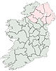
Munster Leinster Ulster Italics denote non-administrative counties. Brackets denote eponymous cities or non-traditional counties. † denotes counties of Northern IrelandCategories:- County Laois
- Leinster
- Counties of the Republic of Ireland
- States and territories established in 1556
- Local administrative units of the Republic of Ireland


Wikimedia Foundation. 2010.