- Dowlish Wake
-
Coordinates: 50°54′31″N 2°53′25″W / 50.9085°N 2.8903°W
Dowlish Wake 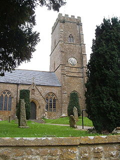
St Andrews Church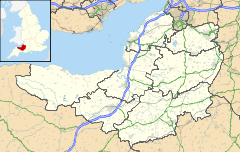
 Dowlish Wake
Dowlish Wake shown within SomersetPopulation 293 [1] OS grid reference ST375125 District South Somerset Shire county Somerset Region South West Country England Sovereign state United Kingdom Post town CHARD Postcode district TA19 Dialling code 01460 Police Avon and Somerset Fire Devon and Somerset Ambulance South Western EU Parliament South West England UK Parliament Yeovil List of places: UK • England • Somerset Dowlish Wake is a small village and civil parish in Somerset, England, situated 2 miles (3 km) south of Ilminster and 5 miles (8 km) north-east of Chard in the South Somerset district. The village has a population of 293[1] and is home to several thatched houses.
The village contains The New Inn pub,[2] and a Pottery and Craft Gallery.[3] The post office closed in 1991.
Contents
History
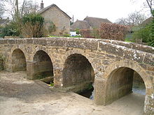 Packhorse bridge
The parish of Dowlish Wake was part of the South Petherton Hundred.[4]
The village is situated on Dowlish Brook, which is crossed by a 17th-century packhorse bridge[5] (widened in the 1990s) and a road bridge dating from the 18th century.[6] There was a flour mill on the brook in the 17th century but only the Mill House survives today.[7] Until the early 1990s parts of the village were regularly cut off by floodwaters between two fords which cross the main road, however this has largely been prevented by recent drainage improvements.
The village was a centre for the manufacture of silk and there are the remains of several limestone quarries. It was on the route of the Chard Canal, which was built around 1835–40 and was intended to be part of a ship canal between the Bristol Channel and the English Channel, but this was never built.
The sports pavilion on the Lawrence Kellett recreation field was rebuilt in 2007.
In 2004 a stone in a village garden, used by a widow to mark the grave of her pet cat, was identified by the village potter as a 9th-century Saxon carving of St Peter.[8]
Governance
As a civil parish Dowlish Wake has its own parish council with responsibility for local issues, including setting an annual precept (local rate) to cover the council’s operating costs and producing annual accounts for public scrutiny. The parish council evaluates local planning applications and works with the local police, district council officers, and neighbourhood watch groups on matters of crime, security, and traffic. The council's role also includes initiating projects for the maintenance and repair of parish facilities, as well as consulting with the district council on the maintenance, repair, and improvement of highways, drainage, footpaths, public transport, and street cleaning. Conservation matters (including trees and listed buildings) and environmental issues are also the responsibility of the council. The village is part of the South Somerset local government district within the wider Somerset County Council, having previously been part of Chard Rural District.[9]
Yeovil is a county constituency represented in the House of Commons of the Parliament of the United Kingdom. It elects one Member of Parliament (MP) by the first past the post system of election. The constituency covers the towns of Yeovil, Chard, Crewkerne and Ilminster in Somerset. Until 1983 Somerset was split into four constituencies and Yeovil constituency also contained the towns of Ilchester, Martock and Somerton but they were moved into the newly created constituency of Somerton and Frome. From the next election, Yeovil constituency will contain Ilchester once again to equalise the populations of the Somerset constituencies. The Boundary Commission for England estimate the electorate of Yeovil constituency after the pending boundary changes to be 77,049. The current MP is David Laws, a member of the Liberal Democrats.[10]
Residents of Dowlish Wake also form part of the electorate for the South West England constituency for elections to the European Parliament,[11] which elects seven MEPs using the d'Hondt method of party-list proportional representation.
Cider Mill
The village is the home of the cider produced at Perrys Cider Mill, manufacturers of several award-winning Ciders.[12] The barn which is used as the cider mill, and now also contains a museum, has 16th-century origins, and may originally have been used as a smithy.[13] A cafe opened at the cider mills in 2008.
Manor house
 Dower House
The hamstone Manor House has 11th-century origins, with the present building being from all periods from the 15th century. It was known as Dowlish Farm by 1688, having been held by the Wake family from the 12th century; it passed through marriage to the Speke family at the end of the 15th century; they sold it in 1920.[14]
Dower House
The Dower House dates from 1664 and was leased to female members of the Speke family during the later 18th century giving the building its name.[15]
Church and hall
The hamstone Norman Church of St Andrew includes fragments of the chancel dating from the 13th century, a 14th-century tower; however, most of the church was rebuilt in 1861–62. It has been designated by English Heritage as a Grade II* listed building.[16]
Speke Hall, next to the church, was used as the day and Sunday school from its erection by William Speke in 1840 until 1949. It now serves as the village hall, hosting regular social functions.[17]
Notable residents
The Manor was the home of the family of John Hanning Speke who took part in 3 expeditions to Central Africa from 1854-1862, the last two in search of the source of the Nile. He discovered Lake Victoria and maintained that it was the source of the White Nile. On his 3rd expedition Speke identified Ripon Falls, the outlet of Lake Victoria, as the source of the Nile; this was confirmed by Henry Morton Stanley in a later expedition. Speke was killed in Neston Park in Wiltshire by his own gun while hunting with his cousin on the 18th of September 1864; Dr David Livingstone and Sir Roderick Murchison, President of the Royal Geographical Society attended his funeral. There is a life size bust of Speke and a memorial to him in the church.Meadowbank was the home of the family of Gary Mortimer, hot air balloonist.[18]
References
- ^ a b "South Somerset population estimates for 2002". Somerset County Council. http://www.webcitation.org/5lRyCVNCk. Retrieved 27 December 2009.
- ^ "Welcome". New Inn. New Inn, Dowlish Wake. http://www.newinn-ilminster.co.uk/. Retrieved 2008-07-16.
- ^ "Chris Brewchorne". Somerset Art Week. Somerset Art Week. http://www.somersetartweek.org.uk/artist.cfm?ID=874&CFID=716654&CFTOKEN=67549176. Retrieved 2008-07-16.
- ^ "Somerset Hundreds". GENUKI. http://www.genuki.org.uk/big/eng/SOM/Miscellaneous/. Retrieved 20 October 2011.
- ^ "Packhorse bridge". Images of England. English Heritage. http://www.imagesofengland.org.uk/Details/Default.aspx?id=262166. Retrieved 2008-07-16.
- ^ "Road bridge over Dowlish Stream, about 20 metres north-west of Mill Farmhouse". Images of England. English Heritage. http://www.imagesofengland.org.uk/Details/Default.aspx?id=262176. Retrieved 2008-07-16.
- ^ "The Mill, Mill Lane, Dowlish Wake". Somerset Historic Environment Record. Somerset County Council. http://webapp1.somerset.gov.uk/her/details.asp?prn=17661. Retrieved 2008-07-16.
- ^ "Cat headstone sells for £200,000". BBC News (BBC). 2004-12-10. http://news.bbc.co.uk/1/hi/england/somerset/4085045.stm. Retrieved 2008-07-16.
- ^ A Vision of Britain Through Time : Chard Rural District
- ^ "Alphabetical List of Constituencies and Members of Parliament". House Of Commons Information Office. Archived from the original on 2008-01-17. http://web.archive.org/web/20080117044453/http://www.parliament.uk/directories/hciolists/alcm.cfm#Y. Retrieved 2008-01-19.
- ^ "UK MEPs for the South West". European Parliament UK Office. Archived from the original on 2007-12-17. http://web.archive.org/web/20071217202015/http://www.europarl.org.uk/uk_meps/southwest.asp. Retrieved 2008-01-11.
- ^ "History". Perry's Farmhouse Cider. Perry's Farmhouse Cider. https://www.perryscider.co.uk/shop/history.asp. Retrieved 2008-07-16.
- ^ "Perry's Cider Mill". Images of England. English Heritage. http://www.imagesofengland.org.uk/Details/Default.aspx?id=262168&. Retrieved 2008-07-16.
- ^ "Dowlish Manor Farmhouse". Images of England. English Heritage. http://www.imagesofengland.org.uk/Details/Default.aspx?id=262162. Retrieved 2008-07-16.
- ^ "The Dower House". Somerset Historic Environment Record. Somerset County Council. http://webapp1.somerset.gov.uk/her/details.asp?prn=57233. Retrieved 2008-07-16.
- ^ "Church of St Andrew". Images of England. English Heritage. http://www.imagesofengland.org.uk/Details/Default.aspx?id=262156. Retrieved 2008-07-16.
- ^ "Spoke Hall, about 10 metres north-west of Church of St Andrew". Images of England. English Heritage. http://www.imagesofengland.org.uk/Details/Default.aspx?id=262161. Retrieved 2008-07-16.
- ^ Lloyd, Clare (1985). The Travelling Naturalists. Christopher Helm Publishers Ltd. ISBN 978-0709916581.
External links
 Media related to Dowlish Wake at Wikimedia CommonsCategories:
- Villages in South Somerset
- Civil parishes in Somerset


Wikimedia Foundation. 2010.