- Downton, Hampshire
-
Coordinates: 50°44′N 1°37′W / 50.74°N 1.62°W
Downton 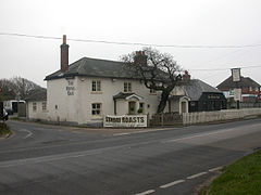
Downton, The Royal Oak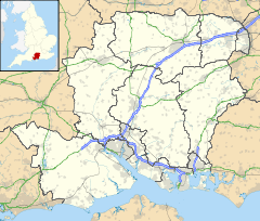
 Downton
Downton shown within HampshireOS grid reference SZ2693 Parish Hordle District New Forest Shire county Hampshire Region South East Country England Sovereign state United Kingdom Post town LYMINGTON Postcode district SO41 Police Hampshire Fire Hampshire Ambulance South Central EU Parliament South East England UK Parliament New Forest West List of places: UK • England • Hampshire Downton is a hamlet in Hampshire, England situated - mostly - around a crossroads on the A337 road where the road from Lymington to New Milton intersects with the road from the original settlement of Hordle northwards. It is mostly in the parish of Hordle, although most of the population live in the part that is in the parish of Milford. Part of the Green belt, its population is static.[1]
History
Downton is first mentioned in the Pipe rolls for 1160 as a 'new place'.[2] The name is first recorded as Dunchinton although more commonly Donketon and Coates states that this is most likely derived from Dunneca's farm or otherwise from *OE dunnocatu-n (farm of hedge sparrows).[3] In 1263 the estate seems to have belonged to Thomas de Orweye although, by 1397, it had expanded to include part of Everton in Milford.[4] After c. 1500 the manor became part of the extensive possessions of the Milles family of Southampton, builders of Hurst Castle. The manor was purchased at end of the 18th century by Sir William Cornwallis (with adjoining manors) whose heir, Mrs. Anne Whitby was the grand mother of last lord of the manor, Col. William Cornwallis-West.[4] He went bankrupt in 1923 and the estate was sold. The western part, owned by the Ashley Clinton family, was sold a few years later although the planned large scale development was prevented.
Piecemeal house building followed for the next few decades. Before the 1980s, the A337 road west of Downton made six sharp turns,[5] but the road has since been straightened.
The region has always been one of dispersed settlement although, with its forge and the inn known as The Royal Oak,[4] Downton provided one centre for the provision of services in Hordle. Whilst the inn remains, today the adjacent businesses are car-related. Currently it is threatened by plans for extensive gravel extraction.[6]
References
- ^ Hordle, Imperial Gazetteer of England and Wales, 1870-72, at visionofbritain.org
- ^ Pipe Rolls 11 Henry II
- ^ R. Coates, Place names of Hampshire, 19
- ^ a b c "Hordle". A History of the County of Hampshire: Volume 5 (1912). http://www.british-history.ac.uk/report.aspx?compid=42057. Retrieved 2010-12-27..
- ^ See the 1940's Ordnance Survey Popular Edition map for an example of the old road layout
- ^ http://www.heri-tage.org.uk/news.htm
Towns, villages and hamlets in the New Forest District of Hampshire, England 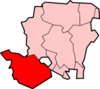
Allum Green | Applemore | Ashlett | Ashley | Ashurst | Bartley | Barton on Sea | Bashley | Beaulieu | Bisterne | Blashford | Blissford | Bolderwood | Boldre | Bramshaw | Bransgore | Breamore | Brockenhurst | Brook | Brookheath | Bucklers Hard | Burgate | Burley | Bull Hill | Cadnam | Calshot | Colbury | Copythorne | Crow | Damerham | Denny Lodge | Dibden | Dibden Purlieu | Downton | East Boldre | East End | East Hill | East Martin | East Mills | Emery Down | Ellingham | Everton | Exbury | Fawley | Fordingbridge | Fritham | Frogham | Furze Hill | Godshill | Gorley Lynch | Hale | Hale Park | Hale Purlieu | Hangersley | Harbridge | Hightown | Highwood | Hordle | Hungerford | Hyde | Hythe | Ibsley | Keyhaven | Lepe | Linbrook | Linford | Linwood | Lopshill | Lower Daggons | Lymington | Lyndhurst | Marchwood | Martin | Milford on Sea | Minstead | Mockbeggar | Netley Marsh | New Milton | Norley Wood | North Gorley | Ossemsley | Pennington | Picket Hill | Picket Post | Pilley | Portmore | Poulner | Ringwood | Rockbourne | Rockford | Sandford | Sandleheath | Shobley | Sopley | South Baddesley | South Gorley | Stuckton | Sway | Tinkers Cross | Tiptoe | Totton and Eling | Walhampton | Whitsbury | Whitsbury Common | Whitsbury Cross | Woodgreen | Woodlands
Categories:- New Forest
- Villages in Hampshire


Wikimedia Foundation. 2010.