- Chaoyang, Liaoning
-
Chaoyang
朝阳
ᠴᠤᠤᠶᠠᠩ— Prefecture-level city — 朝阳市 Location of Chaoyang in Liaoning
Coordinates: 41°18′N 123°46′E / 41.3°N 123.767°E Country China Province Liaoning City Seat Shuangta District Districts and Counties List- Shuangta District
- Longcheng District
- Beipiao City
- Lingyuan City
- Chaoyang County
- Jianping County
- Harqin Left Mongol Autonomous County
Government - CPC Chief Chen Tiexin - Mayor Zhang Tiemin Area[1] - Prefecture-level city 19,698 km2 (7,605.4 sq mi) Population (2007)[2] - Prefecture-level city 3,402,000 - Urban 428,000 Time zone China Standard (UTC+8) Postcode 122000 Area code(s) 421 Website http://www.zgcy.gov.cn/ Chaoyang (simplified Chinese: 朝阳; traditional Chinese: 朝陽; pinyin: Cháoyáng) is a prefecture-level city of Liaoning Province, in the Northeast of the People's Republic of China.
Chaoyang is located almost directly in between the capital of the province, Shenyang, and the capital of China, Beijing. With a vast land area of almost 20,000 square kilometers, it is the largest prefecture in Liaoning, and forms the border with Hebei Province and the Inner Mongolia Autonomous Region.
The area under Chaoyang’s jurisdictional control is split up into two counties (Jianping, Chaoyang), two urban districts (Longcheng, Shuangta), two county-level cities (Beipiao, Lingyuan), and the Harqin Left Wing Mongolian Autonomous County. The total regional population is 3.4 million, while the urban center where the government office is located has a population of 430,000 and forms the core of Chaoyang.
Known as China's 'fossil city', many important paleontological discoveries have been made in Chaoyang, and the Harqin region is the oldest currently known prehistoric site in northern China. Two of the most remarkable Early Cretaceous birds known to date were recovered in the vicinity of the Jiufotang Formation rocks and named Longipteryx chaoyangensis and Sapeornis chaoyangensis in reference to the city.
Contents
Name
The name “Chaoyang” originates from a poem found in one of the oldest collections of Chinese poetry, the Shijing.“A wutong tree grew on a mountain. A fenghuang bird perched at the top and sang towards the morning sun” (Chaoyang’s name means “morning sun” in Chinese). The eastern part of Chaoyang is home to a mountain that has been called Fenghuang Mountain since ancient times. In 1778, this mountain was connected with the poem from the Shijing and Chaoyang was given its current name.
History
Chaoyang has a long and rich history. The discovery of the over five thousand year old Niuheliang Hongshan Cultural Ruins in the region has drawn attention to Chaoyang as one of the birthplaces of ancient Chinese culture.[3] The area first appears in Chinese historical records as “Liucheng County” in the Early Han period of the 3rd century B.C. In 342 AD, King of the Former Yan Murong Huang made Chaoyang his capital under the name Longcheng, and the city remained the capital through the Later Yan and Northern Yan periods.[4] Since this time, Chaoyang has functioned as a center of Buddhism in Northeast China, with the construction of Longxiang temple in 345 AD forming the beginning of Buddhist culture in the Northeast.
The Mongols seized Chaoyang and surrounding regions. It is very difficult to locate nomadic people, but when they submitted to the Manchu Qing Dynasty, Chaoyang was controlled by Chinggisid princes and descendants of Jelme. Their territories became Tümed Right Wing Banner, Kharachin Left Wing Banner, Kharachin Right Wing Banner, and Kharachin Middle Banner, all of which were under Josutu League.[5]
Although the Manchu Empire officially prohibited the Chinese from immigrate to the Mongol land, the southernmost league of Mongolia was flooded by Chinese peasants. As a result, several Chinese prefectures were created within the Mongol land, and the Chinese came under the jurisdiction of the neighboring Chengde-fu. In 1891, a Chinese secret society named Jindandao raised a rebellion, massacring tens of thousands of Mongols and forcing survivors to flee northward.[6]
Under Manchukuo, the eastern part of Chaoyang, including the city of Chaoyang, belonged to Kin-chow Province while the western part constituted Jehol Province.[5] The People's Republic of China incorporated Chaoyang into Liaoning Province in 1955 although ethnic Mongols wished to join Inner Mongolia.[6] It declared a prefecture level city in 1984.[7]
Administrative divisions
The prefecture is divided into 7 administrative areas. There are 2 districts, 2 subordinate cities and 3 counties of which one county is an Autonomous County for the Mongolian minority.
Map 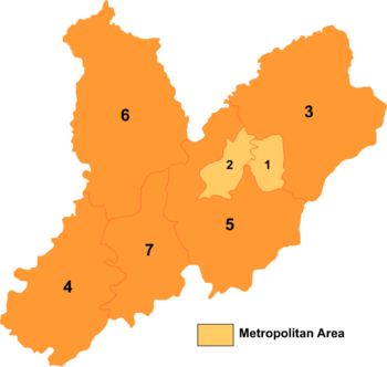
# Name Hanzi Hanyu Pinyin Population
(2003 est.)Area (km²) Density
(/km²)1 Shuangta District 双塔区 Shuāngtǎ Qū 310,000 211 1,469 2 Longcheng District 龙城区 Lóngchéng Qū 170,000 346 491 3 Beipiao City 北票市 Běipiào Shì 620,000 4,583 135 4 Lingyuan 凌源市 Língyuán Shì 650,000 3,297 197 5 Chaoyang County 朝阳县 Cháoyáng Xiàn 620,000 4,216 147 6 Jianping County 建平县 Jiànpíng Xiàn 580,000 4,838 120 7 Harqin Left Wing Mongolian
Autonomous County喀喇沁左翼
蒙古族自治县Kālāqìn Zuǒyì
Měnggǔzú Zìzhìxiàn420,000 2,240 188 Geography
Chaoyang has a rather dry, monsoon-influenced humid continental climate (Koppen Dwa) characterised by hot, humid summers, due to the monsoon, and dry, cold winters, due to the Siberian anticyclone. The four seasons here are distinctive. Nearly half of the annual rainfall occurs in July and August alone. Monthly mean temperatures range from −9.7 °C (14.5 °F) in January to 24.8 °C (76.6 °F) in July, for an annual average of 9.04 °C (48.3 °F).
Climate data for Chaoyang City (1971−2000) Month Jan Feb Mar Apr May Jun Jul Aug Sep Oct Nov Dec Year Average high °C (°F) −2.1
(28.2)1.9
(35.4)9.3
(48.7)18.9
(66.0)25.2
(77.4)28.9
(84.0)30.1
(86.2)29.2
(84.6)24.8
(76.6)17.6
(63.7)7.6
(45.7)0.4
(32.7)16.0 Average low °C (°F) −16.2
(2.8)−12.8
(9.0)−5.2
(22.6)4.3
(39.7)11.3
(52.3)16.6
(61.9)19.9
(67.8)17.9
(64.2)10.8
(51.4)3.3
(37.9)−5.3
(22.5)−12.8
(9.0)2.7 Precipitation mm (inches) 1.5
(0.059)1.6
(0.063)6.5
(0.256)20.0
(0.787)42.4
(1.669)81.1
(3.193)153.8
(6.055)101.4
(3.992)44.7
(1.76)18.2
(0.717)6.5
(0.256)2.9
(0.114)480.6
(18.921)% humidity 43 38 37 38 44 59 73 74 64 53 49 46 51.5 Avg. precipitation days (≥ 0.1 mm) 1.4 1.5 2.7 4.9 7.1 10.7 12.1 9.7 6.8 4.1 2.3 1.3 64.6 Sunshine hours 206.3 207.9 243.3 249.0 263.7 243.4 227.0 235.5 245.4 235.6 199.2 191.4 2,747.7 Source: China Meteorological Administration Economy
Agriculture forms the backbone of Chaoyang's economy. In addition to wheat, corn, beans, and potatoes, Chaoyang is also an important region for the growing of cotton and fruit. The city has also begun to venture into the production of shaji (sea-buckthorn berries), which have become popular in China because of their dual use as food and as medicine. Chaoyang is home to the largest manmade thicket of shaji. Chaoyang has more than 1,600 industrial enterprises, manufacturing a wide range of products including steel, machinery, textiles, diesel engines, automobiles, and paper.[8] Lingyuan Iron and Steel Works and the Liaoning Tyre Factory are two of the largest such enterprises.
Fossils
Liaoning, and in particular Chaoyang, has become the focus of great interest in the world of palaeontology. During the 1990s, many new, unique and fascinating fossils were discovered in this region. Some of the finds have completely revolutionised our ideas of dinosaurs and shed new light on the origin of birds. Chaoyang's fossils are in the Jiufotang Formation. These fossils include: Liaoxipterus, a genus of ctenochasmatid pterodactyloid pterosaur from the Lower Cretaceous; Microraptor, a feathered dinosaur; and several early birds such as Longipteryx Chaoyangensis, Sapeornis Yanornis and Shenzhouraptor an eary bird. Insects have also been found such as Dictyoptera, a fossilised cockroach and Hymenoptera, a fossil bee, which also date to the Lower Cretaceous period. A local trade in rare fossils has developed in the wake of the finds, with an estimated sixty vendors gathering in one area, called Ancient Street.[9]
 Ancient Street
Friendship cities
 Obihiro, Japan - (2000)
References
- ^ "Chaoyang geographical location". Chaoyang Government. http://www.zgcy.gov.cn/cy/cyfc%201-1.html. Retrieved 2010-01-15.
- ^ "Chaoyang demographics". Chaoyang Government. http://www.zgcy.gov.cn/cy/cyfc%201-1.html. Retrieved 2010-01-15.
- ^ "History and Culture". Chaoyang Government. http://www.zgcy.gov.cn/cy/cyfc%203-2.html. Retrieved 2010-01-15.
- ^ "History and Culture". Chaoyang Government. http://www.zgcy.gov.cn/cy/cyfc%203-3.html. Retrieved 2010-01-15.
- ^ a b Yamazaki Sōyo 山崎惣與, Manshū-koku chimei daijiten 滿洲國地名大辭典, p.556, 1941.
- ^ a b Borjigin Burensain ボルジギン・ブレンサイン, Harachin Tomedo imin to kingendai Mongoru shakai ハラチン・トメド移民と近現代モンゴル社会 (Mongolian immigrants from the Qaračin and Tumed areas within modern Mongolian society), Kingendai Uchi Mongoru Tōbu no henyō 近現代内モンゴル東部の変容 (Social and Cultural Change in Eastern Inner Mongolia in the Modern Period), pp. 318-345, 2007.
- ^ "Chaoyang". http://www.xzqh.org. http://www.xzqh.org/quhua/21ln/13chaoyang.htm. Retrieved 2010-01-15.[dead link]
- ^ "Chaoyang". Teach in China. http://www.teach-in-china.cn/chaoyang.php. Retrieved 2010-01-15.[dead link]
- ^ Jerry Guo, "Fossils Fuel a Chinese Boom", Time, August 27, 2007
Coordinates: 41°35′N 120°26′E / 41.583°N 120.433°E
Liaoning Province county-level divisions Shenyang (capital) Shenyang: Shenhe District · Huanggu District · Heping District · Dadong District · Tiexi District · Sujiatun District · Dongling District · Shenbei New Area · Yuhong District · Xinmin City · Faku County · Liaozhong County · Kangping County · Hunnan New Area*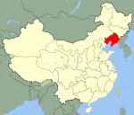 Liaoning in China
Dalian: Xigang District · Zhongshan District · Shahekou District · Ganjingzi District · Lüshunkou District · Jinzhou District (Jinzhou New Area*) · Wafangdian City · Pulandian City · Zhuanghe City · Changhai County
Anshan: Tiedong District · Tiexi District · Lishan District · Qianshan District · Haicheng City · Tai'an County · Xiuyan Autonomous County
Fushun: Shuncheng District · Xinfu District · Dongzhou District · Wanghua District · Fushun County · Xinbin Autonomous County · Qingyuan Autonomous County
Benxi: Pingshan District · Xihu District · Mingshan District · Nanfen District · Benxi Autonomous County · Huanren Autonomous County
Dandong: Zhenxing District · Yuanbao District · Zhen'an District · Fengcheng City · Donggang City · Kuandian Autonomous County
Jinzhou: Taihe District · Guta District · Linghe District · Linghai City · Beizhen City · Heishan County · Yi County
Yingkou: Zhanqian District · Xishi District · Bayuquan District · Laobian District · Dashiqiao City · Gaizhou City
Fuxin: Haizhou District · Xinqiu District · Taiping District · Qinghemen District · Xihe District · Zhangwu County · Fuxin Autonomous County
Liaoyang: Baita District · Wensheng District · Hongwei District · Gongchangling District · Taizihe District · Dengta City · Liaoyang County
Panjin: Xinglongtai District · Shuangtaizi District · Dawa County · Panshan County
Tieling: Yinzhou District · Qinghe District · Diaobingshan City · Kaiyuan City · Tieling County · Xifeng County · Changtu County
Chaoyang: Shuangta District · Longcheng District · Beipiao City · Lingyuan City · Chaoyang County · Jianping County · Harqin Autonomous County
Huludao: Longgang District · Lianshan District · Nanpiao District · Xingcheng City · Suizhong County · Jianchang County■ = Sub-provincial city ■ = Prefecture-level city
*Not a formal administrative areaCategories:- Cities in Liaoning
- Prefecture-level divisions of Liaoning


Wikimedia Foundation. 2010.