- Demopolis Municipal Airport
-
Demopolis Municipal Airport 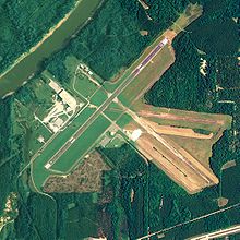
NAIP aerial image, 18 August 2006 IATA: none – ICAO: KDYA – FAA LID: DYA Summary Airport type Public Owner City of Demopolis Serves Demopolis, Alabama Location Marengo County, Alabama Elevation AMSL 112 ft / 34 m Coordinates 32°27′50″N 087°57′15″W / 32.46389°N 87.95417°WCoordinates: 32°27′50″N 087°57′15″W / 32.46389°N 87.95417°W Map Location of airport in Alabama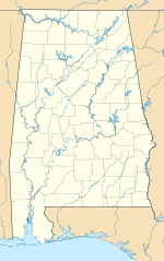
 DYA
DYARunways Direction Length Surface ft m 4/22 5,002 1,525 Asphalt Statistics (2010) Aircraft operations 5,250 Based aircraft 18 Source: Federal Aviation Administration[1] Demopolis Municipal Airport[1][2] (ICAO: KDYA, FAA LID: DYA, formerly 7A2) is a city-owned public-use airport located six nautical miles (7 mi, 11 km) southwest of the central business district of Demopolis, a city in Marengo County, Alabama, United States.[1] It is also known as Demopolis Regional Airport[3] and Julian D. "Buzz" Sawyer Airport.[4]
This airport is included in the FAA's National Plan of Integrated Airport Systems for 2011–2015[5] and 2009–2013,[6] both of which categorized it as a general aviation facility.
Although most U.S. airports use the same three-letter location identifier for the FAA and IATA, this airport is assigned DYA by the FAA but has no designation from the IATA.[7]
Contents
History
During World War II the airfield was built by the United States Army Air Force and opened in October 1943. It was assigned to Third Air Force. It was used to train pilots as an axillary airfield to the group and replacement training center at Key Field, Mississippi. With the end of the war in September 1945, activities at Demopolis Army Airfield were diminished. The airfield was returned to civil control in 1946.[8]
Facilities and aircraft
The airport covers an area of 438 acres (177 ha) at an elevation of 112 feet (34 m) above mean sea level. It has one runway designated 4/22 with an asphalt surface measuring 5,002 by 100 feet (1,525 x 30 m).[1]
For the 12-month period ending September 9, 2010, the airport had 5,250 aircraft operations, an average of 14 per day: 99% general aviation and 1% military. At that time there were 18 aircraft based at this airport: 89% single-engine and 11% multi-engine.[1]
See also
References
- ^ a b c d e FAA Airport Master Record for DYA (Form 5010 PDF). Federal Aviation Administration. Effective 25 August 2011.
- ^ "Demopolis Municipal Airport". City of Demopolis. http://www.demopolisal.gov/airport.html. Retrieved 12 October 2011.
- ^ "Demopolis’ Sawyer tapped for Aviation Hall of Fame". The Demopolis Times. 7 December 2010. http://www.demopolistimes.com/2010/12/07/demopolis%E2%80%99-sawyer-tapped-for-aviation-hall-of-fame/.
- ^ "Airport renamed after Sawyer". The Demopolis Times. 26 April 2011. http://www.demopolistimes.com/2011/04/26/airport-renamed-after-sawyer/.
- ^ "2011–2015 NPIAS Report, Appendix A (PDF, 2.03 MB)". 2011–2015 National Plan of Integrated Airport Systems. Federal Aviation Administration. 4 October 2010. http://www.faa.gov/airports/planning_capacity/npias/reports/media/2011/npias_2011_appA.pdf.
- ^ "2009–2013 NPIAS Report, Appendix A: Part 1 (PDF, 1.33 MB)". 2009–2013 National Plan of Integrated Airport Systems. Federal Aviation Administration. 15 October 2008. http://www.faa.gov/airports/planning_capacity/npias/reports/media/2009/npias_2009_appA_part1.pdf.
- ^ Great Circle Mapper: KDYA - Demopolis Municipal Airport - Demopolis, Alabama
- ^
 This article incorporates public domain material from websites or documents of the Air Force Historical Research Agency.
External links
- Aerial image as of 23 January 1993 from USGS The National Map
- FAA Terminal Procedures for DYA, effective 20 October 2011
- Resources for this airport:
- AirNav airport information for DYA
- FlightAware airport information and live flight tracker
- SkyVector aeronautical chart for DYA
 USAAF Third Air Force in World War II
Airfields Group Training Stations · Replacement Training Stations · Tactical Airfields
Units Commands II Air Support Command · III Air Support Command · III Bomber Command · III Fighter Command · III Reconnaissance Command · III Tactical Air CommandDivisions III Tactical Air DivisionWings 8th Fighter Wing · 9th Fighter Wing · 40th Bombardment WingGroups Air Commando 2nd Air Commando · 3rd Air CommandoBombardment 3rd Bombardment · 12th Bombardment · 17th Bombardment · 21st Bombardment · 29th Bombardment · 30th Bombardment Group · 38th Bombardment · 44th Bombardment · 46th Bombardment · 47th Bombardment · 85th Bombardment · 88th Bombardment · 90th Bombardment · 91st Bombardment · 92nd Bombardment · 93rd Bombardment · 94th Bombardment · 95th Bombardment · 97th Bombardment · 98th Bombardment · 99th Bombardment · 100th Bombardment · 309th Bombardment · 310th Bombardment · 312th Bombardment · 319th Bombardment · 320th Bombardment · 321st Bombardment · 322d Bombardment · 323d Bombardment · 335th Bombardment · 336th Bombardment · 340th Bombardment · 344th Bombardment · 345th Bombardment · 386th Bombardment · 387th Bombardment · 391st Bombardment · 394th Bombardment · 396th Bombardment · 397th Bombardment · 409th Bombardment · 410th Bombardment · 411th Bombardment · 416th Bombardment · 417th Bombardment · 418th Bombardment · 451st Bombardment · 454th Bombardment · 463rd Bombardment · 483rd Bombardment · 488th BombardmentFighter 20th Fighter · 31st Fighter · 49th Fighter · 50th Fighter · 53rd Fighter · 54th Fighter · 56th Fighter · 59th Fighter · 79th Fighter · 80th Fighter · 81st Fighter · 84th Fighter · 85th Fighter · 311th Fighter · 332nd Fighter · 337th Fighter · 338th Fighter · 339th Fighter · 361st Fighter · 369th Fighter · 372nd Fighter · 404th Fighter · 405th Fighter · 408th Fighter · 414th Fighter · 506th FighterFighter-Bomber 27th Fighter-Bomber · 48th Fighter-Bomber · 86th Fighter-Bomber · 406th Fighter-Bomber · 407th Fighter-BomberReconnaissance 2d Reconnaissance · 9th Reconnaissance · 10th Reconnaissance · 26th Reconnaissance · 65th Reconnaissance · 67th Reconnaissance · 68th Reconnaissance · 69th Reconnaissance · 70th Reconnaissance · 75th Reconnaissance · 77th Reconnaissance · 423d Reconnaissance · 424th Reconnaissance · 426th ReconnaissanceCategories:- 1943 establishments
- USAAF Third Air Force Group Training Stations
- USAAF Third Air Force Replacement Training Stations
- Airfields of the United States Army Air Forces in Alabama
- Airports in Alabama
- Buildings and structures in Marengo County, Alabama
- Transportation in Marengo County, Alabama


Wikimedia Foundation. 2010.