- Bellevue, Washington
-
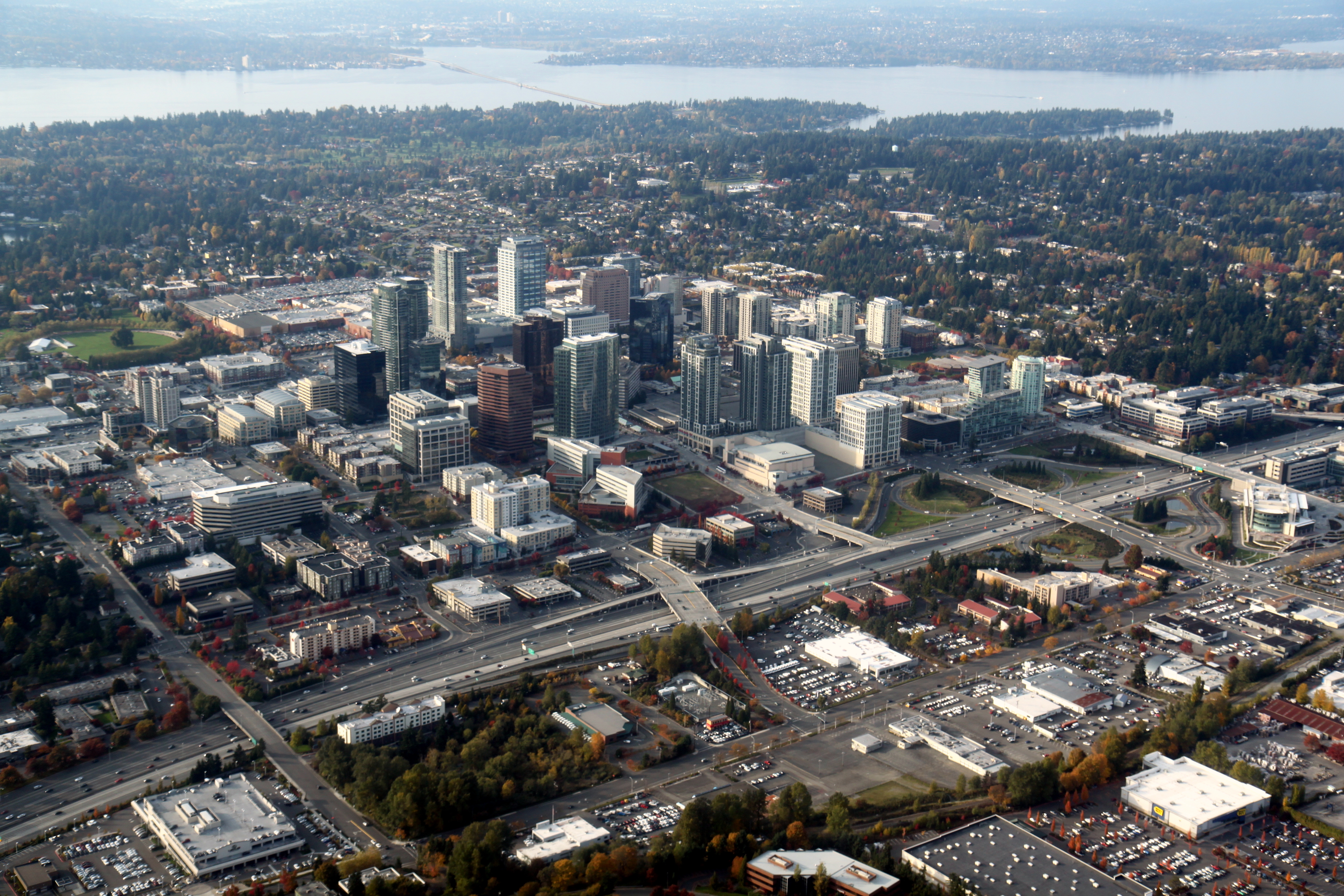
Bellevue — City — City of Bellevue Downtown Bellevue seen in 2011 against the backdrop of Lake Washington

SealLocation of Bellevue within King County, Washington, and King County within Washington. U.S. Census Map
Coordinates: 47°35′51″N 122°9′33″W / 47.5975°N 122.15917°WCoordinates: 47°35′51″N 122°9′33″W / 47.5975°N 122.15917°W Country United States State Washington County King Government – Mayor Don Davidson Area – City 33.9 sq mi (87.8 km2) – Land 30.7 sq mi (79.6 km2) – Water 3.2 sq mi (8.2 km2) Elevation 85 ft (26 m) Population (2010)[1] [2] – City 122,363 – Density 3,947.1/sq mi (1,524/km2) – Metro 3,439,809 Time zone PST (UTC−8) – Summer (DST) PDT (UTC−7) Area code 425 FIPS code 53-05210[3] GNIS feature ID 1512000[4] Website http://www.bellevuewa.gov/ Bellevue (
 /ˈbɛlvjuː/ US dict: bĕl′·vyōō) is a city in the Eastside region of King County, Washington, United States, across Lake Washington from Seattle. Long known as a suburb or satellite city of Seattle,[5] it is now categorized as an edge city or a boomburb.[6] The population was 122,363 at the 2010 census.
Downtown Bellevue is undergoing rapid change. It is currently the second largest city center in Washington state with over 35,000 employees and 5,000 residents.[7] Based on per capita income, Bellevue is the 6th wealthiest of 522 communities in the state of Washington.[8] In 2008, Bellevue was named number 1 in CNNMoney's list of the best places to live and launch a business.[9] More recently, Bellevue was ranked as the 4th best place to live in America.[10] The name "Bellevue" is French for "beautiful view".[11]
Contents
History and growth
Bellevue was founded in 1869 by William Meydenbauer and was officially incorporated on March 21, 1953. Prior to the opening of the Lake Washington Floating Bridge in 1940, Bellevue was a rural area with little development. Once the bridge opened, access from Seattle improved, and the area gradually grew into a bedroom community.[11]
 Bellevue seen from Meydenbauer Bay in 1902
Following the 1963 opening of a second bridge across the lake, the Evergreen Point Floating Bridge, the city began to grow more rapidly. It has since become one of the largest cities in the state, with several high-rise structures in its core and a burgeoning business community.[11]
Reflective of Bellevue's growth over the years is Bellevue Square, now one of the largest shopping centers in the region. Opened in 1946,[11] Bellevue Square underwent a significant expansion in the 1980s. More recently, an expansion to Bellevue Square along Bellevue Way called "The Lodge" and the new One Lincoln Tower promise to strengthen downtown Bellevue's role as the largest Seattle Eastside shopping and dining destination.
The city's long-term plans include the Bel-Red Corridor Project, a large-scale planning effort to encourage the redevelopment of a large northern section of the city bordering the adjacent town of Redmond.[12] Patterned after what many civic leaders consider the successful redevelopment of the downtown core, early plans include "superblock" mixed use projects similar to Lincoln Square. Premised on the 2008 approval of the extension of Link Light Rail to the Eastside, the city hopes to mitigate transportation problems impeding earlier efforts in redeveloping the downtown core; viewed as an economic development opportunity by many in the business and building development community, the process has focused on infrastructure and the encouragement of private construction in a large-scale urban renewal effort.
Geography
Bellevue is located at 47°37′N 122°12′W / 47.61°N 122.2°W (47.597554, -122.159245).[13]
According to the United States Census Bureau, the city has a total area of 33.9 square miles (87.8 km2), of which, 30.8 square miles (79.6 km2) of it is land and 3.2 square miles (8.2 km2) of it (9.29%) is water.
The city's name is derived from a French term for "beautiful view". Under favorable weather conditions, scenic vistas of the Olympic Mountains and Cascade Mountains can be viewed from hilltops (and strategically positioned high-rise buildings) within the incorporated city.
The city lies between Lake Washington to the west and the smaller Lake Sammamish to the east. Much of Bellevue is drained by the Kelsey Creek watershed, whose source is located in the Larsen and Phantom Lake green belt and whose outlet is near where Interstate 90 meets Lake Washington's eastern shore. The city is bisected by Interstate 405 running north-south, and the southern portion is crossed from west to east by Interstate 90. The State Route 520 freeway roughly delineates the upper reaches of Bellevue.
South of I-90 the city surrounds an unincorporated part of King County called Eastgate. South of Eastgate, the city continues up Cougar Mountain. On top of Cougar Mountain, there is another unincorporated King County island called Hilltop. To the west of Cougar Mountain, Bellevue includes the Coal Creek and Factoria neighborhoods.
Bellevue is bordered by the cities of Kirkland to the north and Redmond to the northeast along the Overlake and Crossroads neighborhoods. Across the short East Channel Bridge, I-90 connects Bellevue to Mercer Island to the southwest. Issaquah is to the east, down I-90 at the south end of Lake Sammamish. The city is also bordered to the west by the suburbs of Medina, Clyde Hill, Hunts Point and Yarrow Point. The south end of Bellevue is bordered by the city of Renton, and to the southeast, the relatively recently incorporated city of Newcastle.
Cityscape
Communities within Bellevue include Bridle Trails, Crossroads, Eastgate/Cougar Mountain, Factoria, Newport, Northeast Bellevue, Northwest Bellevue, Sammamish/East Bellevue, Somerset, Sunset, West Bellevue, West Lake Hills, Wilburton, and Woodridge.[14]
Climate
Bellevue Climate chart (explanation) J F M A M J J A S O N D 4.546353.750363.854382.858422.165471.7695217555176571.771523.360464.952405.54635Average max. and min. temperatures in °F Precipitation totals in inches Metric conversion J F M A M J J A S O N D 11482941029712371146531884321112524132524144322118416812411414082Average max. and min. temperatures in °C Precipitation totals in mm Climate data for Bellevue, Washington Month Jan Feb Mar Apr May Jun Jul Aug Sep Oct Nov Dec Year Record high °F (°C) 64
(18)66
(19)78
(26)83
(28)89
(32)92
(33)96
(36)93
(34)93
(34)87
(31)66
(19)62
(17)96
(36)Average high °F (°C) 46
(8)50
(10)54
(12)58
(14)65
(18)69
(21)75
(24)76
(24)71
(22)60
(16)52
(11)46
(8)60 Average low °F (°C) 35
(2)36
(2)38
(3)42
(6)47
(8)52
(11)55
(13)57
(14)52
(11)46
(8)40
(4)35
(2)45 Record low °F (°C) 18
(−8)19
(−7)28
(−2)32
(0)35
(2)42
(6)48
(9)47
(8)42
(6)29
(−2)20
(−7)10
(−12)10
(−12)Precipitation inches (mm) 4.49
(114)3.67
(93.2)3.84
(97.5)2.84
(72.1)2.10
(53.3)1.68
(42.7)0.97
(24.6)0.97
(24.6)1.71
(43.4)3.32
(84.3)4.92
(125)5.45
(138.4)35.96
(913.4)Source: [15] Surrounding cities

Seattle Kirkland Redmond Mercer Island 
Sammamish  Bellevue

Renton Newcastle Issaquah Transportation
 I-405 as seen from the NE 8th Street Overpass
Bellevue is the main Eastside hub for both the local transit authority, King County Metro, and Sound Transit, the regional transit system. The Bellevue Transit Center, which serves both Metro and Sound buses, is located in the heart of the downtown business district and is connected to Interstate 405 by NE 6th St. and a direct-access Texas T HOV ramp. Local buses run into Kirkland, Redmond, Issaquah, Renton, and the University District;[16] regional buses go to Bothell, Lynnwood, Everett, Seattle, Renton, Kent and Auburn, among other cities.[17]
The East Link light rail line is planned to run from Seattle through Mercer Island and Bellevue before ending in Redmond. A measure including this and other regional road and transit projects went before voters on November 4, 2008 and was approved. However, the financial uncertainty of the area's other numerous transportation projects reflect the political fragmentation of the Puget Sound area. What is becoming apparent are the increasing costs associated with the central Puget Sound's regional transportation infrastructure.[18]
The Bellevue City Council has lobbied hard for Sound Transit—a regional transit authority—to construct its light-rail line underground through Bellevue's rapidly growing downtown.[19] But the cost of doing so would exceed the budget that voters approved for that project. Sound Transit has agreed to keep the tunnel option in play during the final phases of design, and Bellevue promised to devote between $104 million to $150 million toward a potential tunnel in the form of cash, services, free access to rights-of-way and one-time tax revenues that result from the East Link project. Bellevue City Council member Claudia Balducci is a member of the Sound Transit board of directors.
The City of Bellevue has undertaken an extensive "Bel-Red Area Transformation" process which seeks to plan some 900 acres (3.6 km2) in the northern portion of the city,[20] all of which is premised on the extension of light rail to the Eastside under Sound Transit 2.[21] The top-down and highly integrated land use and transportation planning is similar to earlier planning for the Downtown.
Bellevue is also served by a railroad, a Burlington Northern branch line known as the Woodinville Subdivision, which includes the historic Wilburton Trestle. This local freight line is the subject of debate over whether to railbank the line and construct a multi-purpose trail. As of March 2009, the Port of Seattle had to postpone its acquisition of the corridor because of instability in the bond market.
Government and politics
 Bellevue City Hall
Bellevue has a Council-Manager form of government with seven, non-partisan council members elected at large for staggered four-year terms.[22] The City Council selects a Mayor from among its members, who serves as council chair but has no veto power. As of 2010, the mayor is Don Davidson, the Deputy Mayor is Conrad Lee and the city's manager is Steve Sarkozy.
The position of Mayor is largely ceremonial in Bellevue as the City Manager runs the City's day-to-day operations. The mayor runs council meetings, helps choose the issues that get on the council's meeting agendas, and serves as the city's most visible spokesperson. The position of Mayor is part-time. In practice, operational authority is held by the City Manager, the position that supervises an employee/consultant form of municipal authority. Indeed, more consideration is given the selection of City Manager than many candidates for City Council, the position of Mayor is elected not by popular vote but by the seven members of Council.
In the 2004 U.S. presidential election, Bellevue residents cast 57.10% of their votes for Democrat John Kerry.[23]
Education
Main article: Bellevue School DistrictBellevue is home to Bellevue College (BC) and City University.
The city hosts the Bellevue School District. There are four main public high schools - Bellevue High School, Interlake High School, Newport High School, and Sammamish High School, as well as two alternative high schools, International School and Robinswood High School, which closed in 2010. Newsweek's 2010 ranking of U.S. public high schools places five of Bellevue's high schools in the top 100 public high schools in the nation.[24] Portions of Bellevue also lie within the boundaries of Lake Washington School District, Renton School District and Issaquah School District.
At the elementary level, Bellevue is home to the Eastside's only Waldorf Education, at Three Cedars School, and to several Montessori schools[citation needed], as well as Bellevue Christian School.
Economy
See also: List of companies based in Bellevue, WashingtonWith its immediate proximity to Redmond, home of Microsoft, and direct highway access to Seattle via Interstate 90 and State Route 520, Bellevue is now home to the headquarters of many small and large businesses, many of which are technology companies that started in the 1990s. The city has numerous thriving commercial districts, including three major shopping centers aside from Bellevue Square: Factoria Mall to the South, Crossroads Mall to the East, and the Overlake Shopping District in the North.
 Panorama of Bellevue, Washington.
Demographics
Historical populations Census Pop. %± 1900 254 — 1910 150 −40.9% 1920 1,213 708.7% 1930 1,071 −11.7% 1940 1,177 9.9% 1950 7,658 550.6% 1960 12,809 67.3% 1970 61,102 377.0% 1980 73,903 21.0% 1990 86,874 17.6% 2000 109,569 26.1% 2010 122,363 11.7% source:[25][26] As of the census[3] of 2000, there were 109,569 people, 45,836 households, and 29,060 families residing in the city. The population density was 3,563.6 people per square mile (1,375.8/km2). There were 48,396 housing units at an average density of 1,574.0 per square mile (607.7/km2). The racial makeup of the city was 74.33% White, 1.99% African American, 0.32% Native American, 17.39% Asian, 0.23% Pacific Islander, 2.54% from other races, and 3.19% from two or more races. Hispanic or Latino of any race were 5.32% of the population.
According to the 2008 American Community Survey, the city's population was 72.9% White (64.2% non-Hispanic-White alone), 27.4% Asian, 2.6% Black or African American, 0.6% American Indian and Alaska Native, 2.9% from some other race and 5.6% from Hispanic or Latino (of any race). Additionally, 4.6% are two or more races. 33.1% are foreign born. 34.5% of the population 5 years and over speak a language other than English at home.[27]
There were 45,836 households out of which 27.5% had children under the age of 18 living with them, 53.0% were married couples living together, 7.5% had a female householder with no husband present, and 36.6% were non-families. 28.4% of all households were made up of individuals and 7.9% had someone living alone who was 65 years of age or older. The average household size was 2.37 and the average family size was 2.93.
In the city the age distribution of the population shows 21.1% under the age of 18, 7.8% from 18 to 24, 32.6% from 25 to 44, 25.0% from 45 to 64, and 13.4% who were 65 years of age or older. The median age was 38 years. For every 100 females there were 98.4 males. For every 100 females age 18 and over, there were 96.6 males.
According to a 2008 estimate, the median income for a household in the city was $81,184, and the median income for a family was $99,822.[28] Males had a median income of $66,456 versus $47,124 for females. The per capita income for the city was $56,905. About 3.8% of families and 5.7% of the population were below the poverty line, including 5.7% of those under age 18 and 6.3% of those age 65 or over.
In 2006 Bellevue was rated one of the 25 safest cities in America,[29] based on the per-capita incidence of violent crime. On the same subject, the Bellevue Police Department is strongly supported by the community.[30]
Culture
Recurring cultural events
Bellevue is the site of the popular annual Bellevue Arts and Crafts Fair (originally Pacific Northwest Arts and Crafts Fair), held since 1947 at the end of July. The biennial Bellevue Sculpture Exhibition draws thousands of visitors to the Downtown Park to view up to 46 three-dimensional artworks from artists around the country. In celebration of its strawberry farming history, Bellevue holds an annual Strawberry Festival.[31] The Bellevue 24-Hour Relay has also been hosted every July in Bellevue Downtown Park.
Places of interest
 Bellevue Arts Museum
The Bellevue Arts Museum first opened in 1975, then moved to Bellevue Square in 1983. In 2001 the museum moved into its own building, designed by Steven Holl. The museum subsequently ran into financial difficulties and was forced to close to the public in 2003. After a lengthy fundraising campaign, a remodel, and a new mission to become a national centre for the fine art of craft and design, the museum re-opened on June 18, 2005 with an exhibition of teapots.[32] The Rosalie Whyel Museum of Doll Art contains one of the largest doll collections in the world—more than a thousand dolls—displayed on two floors of a Victorian-style building.[33] The KidsQuest Children's Museum is located in Factoria Mall. The museum's primary visitors are mothers and care givers with children from pre-crawlers to 12 years of age. Its 10,000-square-foot (930 m2) space houses play and discovery areas, exhibits, offices, educational activities and classroom space. Near Interstate 405 is Meydenbauer Center, a convention center that brings corporate meetings and charity events to the downtown area. Meydenbauer also includes a 410-seat theater which attracts operas, ballets, and orchestral performances.[34]
Sports and recreation
Since the 1970s, the city has taken an active role in ensuring that its commercial development does not overwhelm its natural land and water resources.[35] Today, the Bellevue Parks and Community Services Department manages more than 2,500 acres (10 km2) of parks and open spaces, including the Downtown Park and the Bellevue Botanical Garden, as well as several playgrounds, beach parks, and trails. More than 5,500 Bellevue residents participate in volunteer activities through this department annually.[36]
Bellevue was home to the American Basketball Association team, the Bellevue Blackhawks. The Blackhawks in 2005, despite being ranked 13th in the league, made it to the championship game in front of 15,000 fans in Little Rock, Arkansas.[37] The team has been inactive since 2006.[38]
Well-known residents
Notable people
- Ann Wilson, co-founder of Heart[39]
- Alan White, drummer of progressive rock band Yes
- Nancy Wilson, co-founder of Heart[39]
- Rob McKenna Attorney General of Washington
- Megan Hilty, Broadway Actress
- Jeremiah Slaczka, Co-founder and Creative Director of video game developer 5TH Cell
- Gabe Newell, Co-Founder of Valve Software
- William S. Ayer, President and CEO of Alaska Airlines
- Layne Staley, lead singer of rock band Alice in Chains (1967–2002)
- Marty O'Donnell, lead composer for Bungie Studios
- Ricky "Horror" Olson, Motionless in White bassist, vocals (2009–present)
- Peter Horton, 6' 2" actor from Children of the Corn.
Sportspeople
- John Olerud (former MLB baseball player)[40]
- Evan Meek, MLB (baseball player) Pittsburgh Pirates
- Todd Hollandsworth former major league baseball player
- Tim Lincecum MLB player and starting pitcher for the San Francisco Giants
- Aaron Curry, Linebacker for the Oakland Raiders
- Detlef Schrempf, former NBA player for the Seattle SuperSonics
- Michael Brantley, outfielder for the Cleveland Indians
- Edgar Martinez, former MLB player for the Seattle Mariners
- Martin Harrison, NFL Linebacker for the Seattle Seahawks, San Francisco 49ers and Minnesota Vikings. Newport High School grad in 1985, UW 1990.
- Deon Butler, Wide Receiver for the Seattle Seahawks
- Golden Tate, Wide Receiver for the Seattle Seahawks
- Sigi Schmid, Seattle Sounders FC head coach
Sister cities
Bellevue has the following sister cities:[41][42]
See also
References
- ^ "Annual Estimates of the Population for Incorporated Places Over 100,000, Ranked by July 1, 2007 Population: April 1, 2000 to July 1, 2009". United States Census Bureau, Population Division. July 10, 2008. http://www.census.gov/popest/cities/tables/SUB-EST2009-01.csv. Retrieved June 29, 2010.
- ^ "Population Estimates for the 100 Most Populous Metropolitan Statistical Areas" (PDF). United States Census Bureau. April 5, 2007. http://www.census.gov/Press-Release/www/releases/archives/cb07-51tbl2.pdf. Retrieved June 29, 2010.
- ^ a b "American FactFinder". United States Census Bureau. http://factfinder.census.gov. Retrieved 2008-01-31.
- ^ "US Board on Geographic Names". United States Geological Survey. 2007-10-25. http://geonames.usgs.gov. Retrieved 2008-01-31.
- ^ Danny Westneat (2006-12-14). "Is Bellevue a "new Brooklyn?"". The Seattle Times. http://seattletimes.nwsource.com/html/localnews/2003476791_danny14.html. Retrieved 2007-02-28.
- ^ K. Hinton, A. Tijerino (2001-06-22). ""Boomburbs": The Emergence of Large, Fast-Growing Suburban Cities in the United States" (PDF). Fannie Mae Foundation. http://www.fanniemaefoundation.org/programs/pdf/census/boomburb.PDF. Retrieved 2006-08-10.[dead link]
- ^ "Bellevue Downtown Association". 2007. http://www.bellevuedowntown.org/downtown/econdev.html. Retrieved 2008-06-01.
- ^ "State & County QuickFacts — Bellevue, Washington". United States Census Bureau. http://quickfacts.census.gov/qfd/states/53/5305210.html. Retrieved 2008-07-18.
- ^ "100 best places to live and launch". CNNMoney.com. 2008-07-02. http://money.cnn.com/galleries/2008/fsb/0803/gallery.best_places_to_launch.fsb/index.html. Retrieved 2008-09-24.
- ^ "Best Places to Live". CNNMoney.com. http://money.cnn.com/magazines/moneymag/bplive/2010/snapshots/PL5305210.html. Retrieved 2010-07-16.
- ^ a b c d Stein, Alan J. (1998-11-09). "Bellevue -- Thumbnail History". HistoryLink. http://www.historylink.org/essays/output.cfm?file_id=313. Retrieved 2008-06-09.
- ^ "Bel-Red Area Transformation". City of Bellevue. http://www.ci.bellevue.wa.us/bel-red_intro.htm. Retrieved 2008-07-18.
- ^ "US Gazetteer files: 2010, 2000, and 1990". United States Census Bureau. 2011-02-12. http://www.census.gov/geo/www/gazetteer/gazette.html. Retrieved 2011-04-23.
- ^ "ls_nep400.jpg." City of Bellevue. Retrieved on October 18, 2009.
- ^ "Average Weather for Bellevue, WA - Temperature and Precipitation". Weather.com. http://www.weather.com/outlook/health/fitness/wxclimatology/monthly/graph/USWA0027. Retrieved September 6, 2010.
- ^ http://transit.metrokc.gov/up/sc/rideralert/ra-022008-bellevuetc.html[dead link]
- ^ http://www.soundtransit.org/x1272.xml[dead link]
- ^ http://www.wsdot.wa.gov/Projects/Viaduct/CostEstimates/[dead link]
- ^ Hicks, Joshua Adam (2010-03-23). "Bellevue City Council unanimous on new downtown light-rail tunnel". Bellevue Reporter. Retrieved 2011-06-08.
- ^ "Bel-Red Area Transformation". City of Bellevue. Retrieved 2011-06-08.
- ^ Sound Transit 2. Retrieved 2011-06-08.
- ^ City of Bellevue, Municipal Research and Service Center of Washington
- ^ "Atlas of U.S. Presidential Elections". Dave Leip. http://www.uselectionatlas.org.
- ^ [1], The Top of the Class - The complete list of the 1,500 top U.S. high schools
- ^ Moffatt, Riley. Population History of Western U.S. Cities & Towns, 1850–1990. Lanham: Scarecrow, 1996, 314.
- ^ "Subcounty population estimates: Washington 2000–2009" (CSV). United States Census Bureau, Population Division. 2009-03-18. http://www.census.gov/popest/cities/files/SUB-EST2009-53.csv. Retrieved 2009-04-27.[dead link]
- ^ "Bellevue city, Washington - ACS Demographic and Housing Estimates: 2007". United States Census Bureau. http://factfinder.census.gov/servlet/ADPTable?_bm=y&-geo_id=16000US5305210&-qr_name=ACS_2007_1YR_G00_DP5&-ds_name=&-_lang=en&-redoLog=false. Retrieved 2009-08-23.
- ^ [2]
- ^ Christie, Les (2006-10-30). "http://money.cnn.com/2006/10/30/real_estate/Most_dangerous_cities/index.htm". CNNMoney.com. http://money.cnn.com/2006/10/30/real_estate/Most_dangerous_cities/index.htm. Retrieved 2008-07-18.
- ^ City of Bellevue - Police earn high marks in survey
- ^ "Bellevue Strawberry Festival". 2008. http://www.bellevuestrawberryfestival.org/Index.asp. Retrieved 2008-06-07.
- ^ Pastier, John (2001-01-08). "Bellevue Art Museum". HistoryLink.org. http://www.historylink.org/essays/output.cfm?file_id=2936. Retrieved 2006-12-07.
- ^ "Rosalie Whyel Doll Museum". 2006. http://www.dollart.com/. Retrieved 2006-12-07.
- ^ Wallace, Robert (July 8, 2007). "Study Meydenbauer expansion options carefully". Puget Sound Business Journal. http://www.bizjournals.com/seattle/stories/2007/07/09/focus5.html. Retrieved December 16, 2010.
- ^ Girling, Cynthia L.; Helphand, Kenneth I. (1996). Yard, Street, Park: The Design of Suburban Open Space. John Wiley and Sons. pp. 213–216. ISBN 9780471178446. http://books.google.com/books?id=u6xqBKdpSdgC&pg=PA213.
- ^ Bellevue Parks & Community Services (2010). "Bellevue Parks at a Glance". http://www.bellevuewa.gov/pdf/Parks/bellevue_parks_at_a_glance.pdf. Retrieved December 16, 2010.
- ^ "IBAC Corporation Unit Announces Alignment with the American Basketball Associations (ABA) Arkansas Rivercatz". Business Wire. November 1, 2006. http://goliath.ecnext.com/coms2/gi_0199-5978352/IBAC-Corporation-Unit-Announces-Alignment.html. Retrieved December 16, 2010.
- ^ Caputo, Matt; Munson, Chris (December 3, 2008). "Dead Balls: A reporter exposes the ABA graveyard". SLAM Magazine Online. http://www.slamonline.com/online/columnists/2008/12/dead-balls/. Retrieved December 16, 2010.
- ^ a b Peterson, Matt (September 17, 2002). "Spotlight: Sammamish High School". The Seattle Times. http://community.seattletimes.nwsource.com/archive/?date=20020917&slug=school17e
- ^ "Olerud inducted into WIAA Hall of Fame". May 2, 2009. http://www.pnwlocalnews.com/east_king/bel/sports/43180557.html
- ^ "Washington's Sister Cities, Counties, States and Ports". Washington State Lieutenant Governor's Office. http://www.ltgov.wa.gov/International/Washington%20Organizations/Sisters/.
- ^ "Online Directory: Washington, USA". Sister Cities International. http://www.sister-cities.org/icrc/directory/usa/WA.
External links
Categories:- Cities in the Seattle metropolitan area
- Bellevue, Washington
- Populated places established in 1869


Wikimedia Foundation. 2010.