- Monticello, Guilford County, North Carolina
-
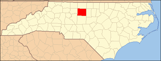
Monticello — Unincorporated area — Location within the state of North Carolina
 Monticello
Coordinates: 36°13′9″N 79°40′40″W / 36.21917°N 79.67778°WCoordinates: 36°13′9″N 79°40′40″W / 36.21917°N 79.67778°W Country United States State North Carolina County Guilford Time zone Eastern (EST) (UTC-5) – Summer (DST) EDT (UTC-4) ZIP codes FIPS code GNIS feature ID 990156 Monticello is an unincorporated area in Guilford County, North Carolina northeast of Browns Summit, North Carolina, northeast of U.S. Route 29, on North Carolina Highway 150. Its elevation is 843 feet or 257 m.
Other communities in North Carolina
Another community named Monticello is located in Iredell County, North Carolina at coordinates 354756N 0805606W, and another was located in Washington County, North Carolina at coordinates 35.7657178 -76.7363312 354557N 0764411W, but no longer exists, according to the Geographic Names Information System of the United States Geological Survey.[1]
References
Municipalities and communities of Guilford County, North Carolina Cities Archdale‡ | Burlington‡ | Greensboro | High Point‡

Towns Gibsonville‡ | Jamestown | Kernersville‡ | Oak Ridge | Pleasant Garden | Sedalia | Stokesdale | Summerfield | Whitsett
CDPs Unincorporated
communitiesBrowns Summit | Climax | Colfax | Julian | Monticello
Footnotes ‡This populated place also has portions in an adjacent county or counties
Categories:- Populated places in Guilford County, North Carolina
- Unincorporated communities in North Carolina
- North Carolina geography stubs

Wikimedia Foundation. 2010.