- Sevierville, Tennessee
Infobox Settlement
official_name = Sevierville, Tennessee
settlement_type =City
nickname =
motto =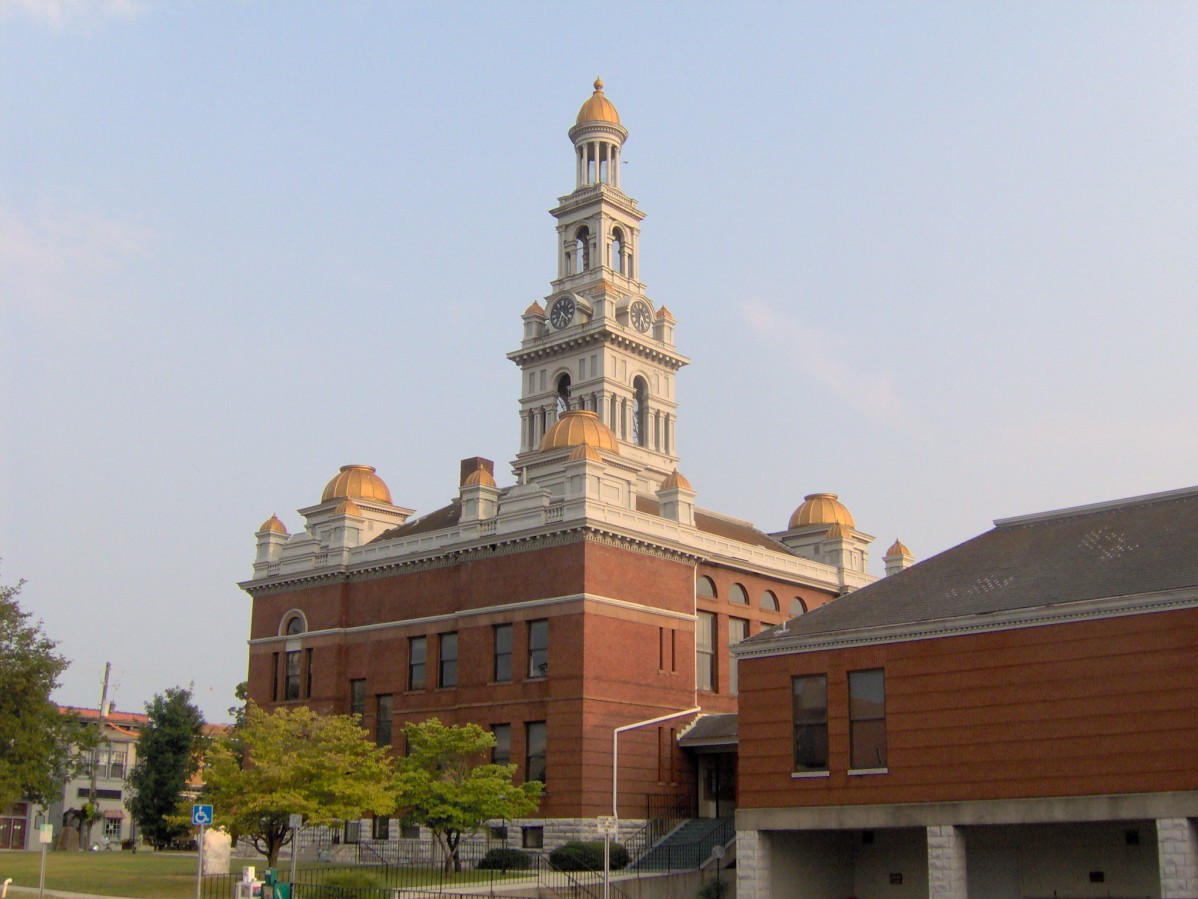
imagesize = 200px
image_caption = Sevier County Courthouse
image_
mapsize = 250px
map_caption = Location inTennessee
mapsize1 =
map_caption1 =
subdivision_type = Country
subdivision_type1 = State
subdivision_type2 = County
subdivision_name =United States
subdivision_name1 =Tennessee
subdivision_name2 = Sevier
government_type =
leader_title =Mayor
leader_name = Bryan Atchley (R)
established_title = Founded
established_title2 = Incorporated
established_date = 1795
established_date2 = 1901
area_magnitude =
area_total_sq_mi = 20.0
area_total_km2 = 51.8
area_land_sq_mi = 19.9
area_land_km2 = 51.5
area_water_sq_mi = 0.1
area_water_km2 = 0.3
area_water_percent = 0.50
area_urban_sq_mi =
area_urban_km2 =
area_metro_sq_mi =
area_metro_km2 =
population_as_of = 2004
population_note =
population_total = 14101
population_metro =
population_urban =
population_density_sq_mi = 591.1
population_density_km2 = 228.2
timezone = EST
utc_offset = -5
timezone_DST = EDT
utc_offset_DST = -4
latd = 35 |latm = 52 |lats = 39 |latNS = N
longd = 83 |longm = 34 |longs = 12 |longEW = W
elevation_ft = 903
elevation_m = 275
website = http://www.seviervilletn.org
postal_code_type =
postal_code =
area_code = 865
blank_name = FIPS code
blank_info = 47-67120GR|2
blank1_name = GNIS feature ID
blank1_info = 1307042GR|3
footnotes =Sevierville (pronEng|səˈvɪərvɪl) is a city in
Sevier County, Tennessee , located in the Southeastern United States. Itspopulation was 11,757 at the 2000 United States Census; in 2004 the estimated population was 14,101. Sevierville is thecounty seat GR|6 ofSevier County, Tennessee .Geography
Sevierville is located at coor dms|35|52|39|N|83|34|12|W|city (35.877560, -83.569927)GR|1. In the town's eastern section, the Little Pigeon River is formed by the confluence of its East Fork and Middle Fork, both of which flow down from their sources high in the
Great Smoky Mountains . Five miles downstream to the west, the Little Pigeon absorbs its West Fork before turning north and flowing for another five miles (8 km) to its mouth along theFrench Broad River . Sevierville is centered around the stretch of land between these two junctions of the East and Middle Fork and the West Fork, known traditionally as Forks-of-the-Pigeon or Forks-of-the-River.Sevierville is situated in an area where the Foothills of the Great Smokies give way to the
Tennessee Valley , and thus the town has long acted as a nexus between Knoxville to the north and theAppalachia n towns in the mountains to the south. TheGreat Smoky Mountains National Park is located approximately ten miles south of Sevierville.Due to its hilly terrain and the relatively poor roads of 19th-century Sevier County, a number of smaller communities developed independently along the outskirts of Sevierville. These include Harrisburg and Fair Garden to the east and Catlettsburg and Boyd's Creek to the north. In addition, the
United States Postal Service associates the name "Sevierville" withZIP codes for much of Sevier County, including the town of Pittman Center and other geographically extensive areas located outside Sevierville's city limits.Several major state and federal highways intersect in Sevierville.
U.S. Route 441 , commonly called "The Parkway," connects Sevierville with Knoxville to the north and the national park andCherokee, North Carolina to the south. The Sevierville section of US-441 has been named "Forks-of-the-River Parkway." State Route 66, also called Winfield Dunn Parkway, connects Sevierville withInterstate 40 to the north.U.S. Route 411 traverses Sevierville from east to west, connecting Sevierville with Blount County and Cocke County. State Route 416 connects Sevierville with Pittman Center andU.S. Route 321 at the park boundary to the southeast.According to the
United States Census Bureau , the city has a total area of 20.0 square miles (51.8 km²), of which, 19.9 square miles (51.5 km²) of it is land and 0.1 square miles (0.3 km²) of it (0.50%) is water.Demographics
As of the
census GR|2 of 2000, there were 11,757 people, 5,002 households, and 3,206 families residing in the city. Thepopulation density was 591.1 people per square mile (228.2/km²). There were 5,787 housing units at an average density of 291.0/sq mi (112.3/km²). The racial makeup of the city was 95.64% White, 1.17% African American, 0.37% Native American, 0.93% Asian, 0.02% Pacific Islander, 0.73% from other races, and 1.16% from two or more races. Hispanic or Latino of any race were 1.62% of the population.There were 5,002 households out of which 28.5% had children under the age of 18 living with them, 47.3% were married couples living together, 13.2% had a female householder with no husband present, and 35.9% were non-families. 30.4% of all households were made up of individuals and 12.2% had someone living alone who was 65 years of age or older. The average household size was 2.27 and the average family size was 2.82.
In the city the population was spread out with 22.1% under the age of 18, 9.8% from 18 to 24, 28.9% from 25 to 44, 23.2% from 45 to 64, and 16.0% who were 65 years of age or older. The median age was 37 years. For every 100 females there were 89.0 males. For every 100 females age 18 and over, there were 84.2 males.
The median income for a household in the city was $30,623, and the median income for a family was $37,972. Males had a median income of $27,247 versus $19,401 for females. The
per capita income for the city was $18,576. About 14.5% of families and 16.9% of the population were below thepoverty line , including 24.1% of those under age 18 and 17.2% of those age 65 or over.Sevierville is the principal city of the Sevierville, Tennessee
Micropolitan Statistical Area which includes all of Sevier County and is a component of the Knoxville-Sevierville-La FolletteCombined Statistical Area .History
Native Americans of the
Woodland period were among the first human inhabitants of what is now Sevierville, arriving sometime around 200 A.D. and living in villages scattered around the Forks-of-the-River area. [Tennessee Historical Commission Marker, "McMahan Indian Mound," in Sevierville, Tennessee. Information accessed 3 September 2007.]Between 1200 and 1500 A.D., during the Dallas Phase of the Mississippian period, a group of Native Americans established a relatively large village centered around a temple mound just above the confluence of the West Fork and the Little Pigeon River. This mound was approximately convert|16|ft|m high and convert|240|ft|m across and was surrounded by a
palisade . An excavation in 1881 unearthed burials, arrow-points, a marble pipe, glass beads, pottery, and engraved objects. [William Holmes, " [http://www.ibiblio.org/pub/docs/books/gutenberg/1/9/4/1/19416/19416.txt Illustrated Catalogue of a Portion of the Collection Made During the Field Season of 1881] ." "Third Annual Report of the Bureau of Ethnology to the Secretary of the Smithsonian Institution, 1881-82" (Washington: Government Printing Office, 1884), 427-510. Transcribed for use online by Project Gutenburg, 2006. Retrieved: 4 October 2007.] At the time of this first excavation, the mound was located on a farm owned by the McMahan family, and was thus given the name McMahan Indian Mound.By the early 1700s, the
Cherokee controlled much of the Tennessee side of the Smokies, establishing a series of settlements along theLittle Tennessee River . A section of theGreat Indian Warpath forked at the mouth of Boyd's Creek, just north of Sevierville. The main branch crossed the French Broad and continued along Dumplin Creek to the Nolichucky basin in northeastern Tennessee. The other branch, known as the Tuckaleechee and Southeastern Trail, turned south along the West Fork of the Little Pigeon River. This second branch forked again at modern-day Pigeon Forge, with the main trail turning east en route to Little River and the other branch, known as the Indian Gap Trail, crossing the crest of the Smokies to the south and descending into the Oconaluftee area of North Carolina. [Robbie Jones, "The Historic Architecture of Sevier County, Tennessee" (Sevierville, Tenn.: Smoky Mountain Historical Society, 1997), 3-7.] The various Cherokee trails criss-crossing Sevier Co. brought the first Euro-American traders and settlers to the area.Early Euro-American settlement
European long hunters and traders arrived in the Sevierville area in the mid-1700s. Isaac Thomas (1735?-1818), the most notable of these early traders, was well-respected by the Cherokee, and may have lived at the Overhill town of Chota at one time. [" [http://freepages.genealogy.rootsweb.com/~cafamilies/thomas/isaac.html Isaac Thomas & Elizabeth Massengill] ." 13 April 2001. The source quotes Jean Fladger Shanelec, "For His Own Personal Adventure", 1996. Retrieved: 26 September 2007.] Europeans like Thomas were mainly in search of animal furs, for which they exchanged manufactured goods.
As settlers began to trickle into East Tennessee, relations with the Cherokee began to turn hostile. During the Revolutionary War, the Cherokee, who had aligned themselves with the British, launched sporadic attacks against the sparse settlements in the Tennessee Valley. In December of 1780, Col. John Sevier, fresh off a victory over the British at
King's Mountain , launched apunitive expedition against the Cherokee. Sevier routed the Cherokee at the Battle of Boyd's Creek and proceeded to destroy several Cherokee settlements along the Little Tennessee.A temporary truce secured by James White in 1783 led to an influx of Euro-American settlers in the French Broad valley. [Goodspeed Publishing Company, " [http://www.smokykin.com/smhs/sevier.html Sevier County] ." "History of Tennessee" (1887), B32-35. Transcribed for the web by Cliff Manis with revision by Robert Beckwith, 1996. Retrieved: 4 October 2007.] Hugh Henry (1756-1838) erected a small fort near the mouth of Dumplin Creek in 1782 known as Henry's Station. He was joined the following year by Samuel Newell (1754-1841), who established Newell's Station along Boyd's Creek, and Joshua Gist, who settled near the creek's mouth. Other early forts in the area included Willson's Station at the confluence of the East and Middle Fork of the Little Pigeon and Wear's Fort at the junction of the Southeastern and Tuckaleechee Trail and Indian Gap Trail. [J.G.M. Ramsey, "The Annals of Tennessee" (Johnson City, Tenn.: Tennessee Overmountain Press, 1999), 369.] [Jones, "Historic Architecture of Sevier County", 3, 11.] The Cherokee signed away all rights to what is now Sevier County in the 1785 Treaty of Dumplin, which was negotiated at Henry's Station.
In 1783, Isaac Thomas established a farm, trading post, and tavern at the confluence of the West Fork and the Little Pigeon River. He was joined shortly thereafter by Spencer Clack (1740-1832) and James McMahan, and a community known as Forks of the Little Pigeon developed around them. In 1789, Reverend Richard Wood (1756-1831) established Forks-of-the-River Baptist Church, which reported a congregation of 22 in 1790. By 1795, the congregation had 94 members. [Jones, "Historic Architecture of Sevier County", 14.]
Antebellum Sevierville
Sevier County was created in 1794 and named after John Sevier. At a meeting at Thomas's house the following year, the Forks-of-the-Little-Pigeon area was chosen as the county seat, and renamed "Sevierville." [J.G.M. Ramsey, "The Annals of Tennessee" (Johnson City, Tenn.: Tennessee Overmountain Press, 1999), 637.] James McMahan donated a 25 acre tract upon which to erect a townsquare. This tract was parceled out into half-acre lots upon which the purchaser was required to build a brick, framed, or stone structure. [J.A. Sharp, " [http://www.sevierlibrary.org/genealogy/drsharphis/sevierville.htm Sevierville, One Hundred Fifty-Five Years Old] ." c. 1950. Retrieved: 4 October 2007.]
The first Sevier County Courthouse was built in 1796. Before its construction, according to local legend, court was held in a flee-infested abandoned stable. Irritated lawyers were said to have paid an unknown person "a bottle of whiskey" to burn down the stable, forcing the new county to build an actual courthouse. [Goodspeed Publishing Company, " [http://www.smokykin.com/smhs/sevier.html Sevier County] ." "History of Tennessee" (1887), B32-35. Transcribed for the web by Cliff Manis with revision by Robert Beckwith, 1996. Retrieved: 4 October 2007.]
As the county grew, several large farms were established in the fertile Boyd's Creek area. In 1792, Andrew Evans purchased a tract of land near the mouth of Boyd's Creek and built a ferry near the site of the old ford. In 1798, Evans sold the farm to John Brabson, and it was henceforth known as the Brabson Ferry Plantation. In the early 1790s, Thomas Buckingham established a large farm between Boyd's Creek and Sevierville. Buckingham went on to become the county's first sheriff. In the early 1800s, John Chandler (1786-1875) established the plantation along Boyd's Creek now known as "Wheatlands." [Jones, "Historic Architecture of Sevier County", 14, 24.]
As towns situated along the French Broad are connected via waterway to
New Orleans , aflatboat trade flourished along the river in the early 1800s. In 1793, James Hubbert, who lived along Dumplin Creek, established Hubbert's Flat Landing to trade with flatboats moving up and down the river. [Jones, "Historic Architecture of Sevier County", 17.]In the early 1800s, Knoxville and Asheville were connected via Route 17, a crude road which followed the banks of the French Broad. This new road gave Tennessee's cattle drovers greater access to markets along the east coast. In 1820, a stagecoach road connected Sevierville with Maryville to the west. [Jones, "Historic Architecture of Sevier County", 19.] Sevierville's situation as a county seat along these early roads helped it to grow. By 1833, the town had a population of 150, including two doctors, two carpenters, a tanner, two tailors, a shoemaker, three stores, a hatter, two taverns, and two mills. [Jones, "Historic Architecture of Sevier County", 21.] Distilleries were popular means of supplemental income. By 1850, John Chandler's distillery was producing 6,000 gallons of whiskey per year. [Jones, "Historic Architecture of Sevier County", 29.]
A notable late arrival in Sevierville was Dr. Robert Hodsden (1806-1864), who had accompanied the Cherokee on the
Trail of Tears . In 1844, Hodsden began construction on a plantation near Fair Garden, just outside of Sevierville to the east. This plantation, now known as Rose Glen, was worth $28,000 in 1860, one of the most valuable in the county. [Jones, "Historic Architecture of Sevier County", 22, 29.]In 1856, a fire swept through Sevierville, burning a recently-constructed new courthouse, 41 houses, and several shops in the downtown area. Perhaps more importantly, the county lost nearly all of the vital records of its early settlers. [M.A. Rawlings, "Sevierville Fire of 1856," "Smoky Mountain Historical Society Newsletter" 12, no. 4 (Winter of 1986), 95.]
The Civil War
Slavery wasn't common in Sevier County, although it did occur, especially at the large plantations along the French Broad River. Even before the war, Sevierville, a hotbed of abolitionist activity, was home to a relatively large community of free African-Americans. [Jones, "Historic Architecture of Sevier County", 27.] In 1861, only 3.8% of Sevier Countians voted in favor of secession from the Union. [Jones, "Historic Architecture of Sevier County", 33.]
In late 1861, a pro-secession speech delivered by Henry Foote met with an angry response in Sevierville, and was followed by a series of explosive anti-secession speeches. The following year, Knoxville
abolitionist Parson Brownlow gave a rousing anti-secession speech in Sevierville en route to a hide out in Wears Valley. Brownlow's audience remained gathered throughout the night after a (false) rumor spread that Confederate forces were approaching. [Jones, "Historic Architecture of Sevier County", 35.] Union supporters in Sevier County were harassed and threatened throughout the war, even after Union forces underAmbrose Burnside occupied Knoxville in September 1863.Sevierville, situated at a major crossroads south of Knoxville, suffered consistent harassment, looting, and confiscation of property by both Union and Confederate forces moving through the town in 1863 and 1864. Vance Newman, a Union recruiting officer living in Sevierville at the time, later recalled:
A guard of rebel soldiers in 1864 threatened to burn my house, and the rebel soldiers so often threatened to take my life that I cannot particularize. They were always after me because of my Union sentiments. [U.S. National Archives Microfilm Publication P2257. "Records of the U.S. House of Representatives: Southern Claims Commission, 1871-1880". Part II, Vol. II, Claim No. 21037 (Vance Newman), submitted 1876.]
After Confederate General
James Longstreet failed to retake Knoxville in theBattle of Fort Sanders , Union and Confederate forces quickly initiated a series of maneuvers to gain control of the strategic fords along the French Broad, culminating in an engagement near Hodsden's farm at Fair Garden in January 1864. Although the Union forces were victorious, they were later forced to retreat for lack of supplies. A state of general anarchy ensued, continuing until the end of the war. On October 30, 1864, Sevierville resident Terressa McCown wrote in her diary:The robbers have come at last, they robbed my husband of his pocketbook, money and papers and pocket knife. Times get worse everyday. We know not what will come next. I feel this morning like nothing but destruction awaits us. [Mary Rury, "The Diary of Terressa Ann Lanning McCown," "Smoky Mountain Historical Society Newsletter" 12, no. 4 (Winter of 1986), 99.]
At the war's end, the county's few remaining Confederate sympathizers, most notably members of the Brabson family, were forced to flee. [Jones, "Historic Architecture of Sevier County", 37-39.]1880-present
Sevierville recovered quickly from the war, with a number of new houses and businesses being built in the 1870s. Two members of the town's African-American community — architect Lewis Buckner (1856-1924) and brickmason Isaac Dockery (1832-1920) — would play a prominent role in Sevierville's post-war construction boom. Buckner designed a number of houses in the Sevierville area over a 40-year period, 15 of which still stand. [Robbie Jones, " [http://tennesseeencyclopedia.net/imagegallery.php?EntryID=B109 Lewis C. Buckner] ." "The Tennessee Encyclopedia of History and Culture", 2002. Retrieved: 2 October 2007.] Dockery's greatest contributions include the New Salem Baptist Church in 1886 and the Sevier County Courthouse in 1896, both of which still stand. [Robbie Jones, " [http://tennesseeencyclopedia.net/imagegallery.php?EntryID=D039 Isaac Dockery] ." "The Tennessee Encyclopedia of History and Culture", 2002. Retrieved: 2 October 2007.]
By the 1880s, Sevierville was growing rapidly as the population of Sevier County swelled. In 1887, the town had four general stores, two groceries, a jeweler, a sawmill, and two hotels. It was also home to the Sevierville Lumber Company, which had recently been established to harvest trees in the area. Tourists also started to trickle into Sevier County, drawn by the health-restoring qualities of mountain springs. Resorts sprang up throughout the county, with Seaton Springs and Henderson Springs located just south of Sevierville. [Jones, "Historic Architecture of Sevier County", 49-50.]
In 1892, a vigilante group known as the Whitecaps formed to rid Sevier County of vice. The group wore white hoods to conceal their identities and used
Ku Klux Klan -like tactics, although they weren't considered a racist entity. While the Whitecaps initially threatened women accused of prostitution, the group quickly spiraled out of control, launching nightly attacks in the mid-1890s. In 1893, Sevierville physician J.A. Henderson took over an anti-Whitecap group, which he renamed the "Blue Bills." The two vigilante groups clashed at Henderson Springs in 1894, with deaths on both sides. In 1896, the Whitecaps' murder of a young Sevierville couple led to widespread outrage, and in 1898, the Tennessee State Legislature banned "extra-legal conspiracies" and vigilante groups. Due to this measure and the efforts of Sevier County Deputy Sheriff Thomas Davis, the Whitecaps had largely vanished by the end of the century. [Jones, "Historic Architecture of Sevier County", 63-64.]After a fire destroyed much of the downtown area in 1900, businesses shifted from the old town square at Main Street to the new Sevierville Commercial District, viz. Court Avenue and Bruce Street, which was centered around the new courthouse. [Jones, "Historic Architecture of Sevier County", 66.] The town incorporated in 1901. [J.A. Sharp, " [http://www.sevierlibrary.org/genealogy/drsharphis/sevierville.htm Sevierville, One Hundred Fifty-Five Years Old] ." c. 1950. Retrieved: 4 October 2007.]
In 1910, Indiana entrepreneur William J. Oliver finished work on the Knoxville, Sevierville and Eastern Railroad, which was Sevier County's first
standard gauge rail line. Known as theSmoky Mountain Railroad , this line offered passenger service between Knoxville and Sevierville until 1962. [Jones, "Historic Architecture of Sevier County", 67.]With the opening of the Great Smoky Mountains National Park in 1934, tens of thousands of tourists began passing through Sevierville, which was situated about halfway between the park and Knoxville. US-441, initially known as the Smoky Mountain Highway, was completed to Sevierville in 1934, and later extended to North Carolina. [Jones, "Historic Architecture of Sevier County", 124-125.]
Country music singer
Dolly Parton was born in Sevierville in 1946. The Parton family migrated to Greenbrier sometime around 1850, and later moved to Locust Ridge (near Pittman Center) after establishment of the national park.Economy
Like other towns situated along the Parkway in Sevier County, Sevierville has reaped the benefits of the burgeoning tourism industry brought on by the development of the
Great Smoky Mountains National Park . As of 2004, nearly fifty percent of businesses based in Sevierville were linked to tourism. For example, there are over 2,000hotel andmotel rooms in the city today, generating more than $500,000(USD) in hotel-motel tax revenues each year.In spite of the local tourism boom, however, Sevierville is still the most traditional community in the county. With almost twice the population of Pigeon Forge and Gatlinburg combined, local industry accounts for twenty percent of the city's economy, and most of the practical services of daily life, such as
hospital s and car dealerships, are found nowhere else in the county.East Tennessee Radio Group owns and operates the Sevierville area's primary local radio stations, WSEV-AM 930 (sports talk from
ESPN Radio ) and FM 105.5 (adult contemporary music, known as "Mix 105.5"). Also,WWST -FM "Star" 102.1, aTop 40 music station serving the Knoxville market, is licensed by theFCC to Sevierville.Education
Sevierville is served by the Sevier County public school system. The educational system in Sevierville consists of the following public institutions:
* Elementary-Grammar level:
** Sevierville Primary School - Grades: Kindergarten-Second, Enrollment: 737
** Sevierville Intermediate School - Grades: Third-Fifth, Enrollment: 699
** T. Lawson Early Childhood - Grades: Pre-Kindergarten--Kindergarten, Enrollment: 21
* Elementary-Grammar/Junior High level:
** Catons Chapel Elementary School - Grades: Kindergarten-Eighth, Enrollment: 397
** New Center Elementary School - Grades: Kindergarten-Eighth, Enrollment: 748
** Wearwood Elementary School - Grades: Kindergarten-Eighth, Enrollment: 226
* Junior High level:
** Sevierville Middle School - Grades: Sixth-Eighth, Enrollment: 722
* Junior High/Secondary level:
** Hardin Alternative Learning Center - Grades: Seventh-Twelfth, Enrollment: 36
** Parkway Academy - Grades: Sixth-Twelfth, Enrollment: 41
* Secondary level:
** Sevier County High School - Grades: Ninth-TwelfthSevierville is also home to the following private institutions:
* Elementary-Grammar level:
** Riverside Academy - Grades: Pre-Kindergarten--Fourth, Enrollment: 35
** Becky B's Busy School: - Grades: Kindergarten-Second, Enrollment: n/a
* Elementary-Grammar/Junior High/Secondary level:
** Covenant Christian Academy - Grades: Pre-Kindergarten--Twelfth, Enrollment: 450
** St. Andrew's School - Grades: Third-Twelfth, Enrollment: 26
* Ungraded:
** New Center Christian School - Enrollment: 11In addition to the preceding institutions, Sevierville is home to the Sevier County satellite campus of
Walters State Community College , based inMorristown, Tennessee .Points of interest
* Burchfield Grove Memorial Arboretum
* The Tennessee Museum of Aviation
Registered historic sites
* The Sevier County Courthouse, completed in 1896. Sevier County's fifth courthouse. The building was designed by the McDonald Brothers of Louisville and constructed by C.W. Brown of Lenoir City. [Beulah Linn, "The Centennial of Sevier County's Fifth Courthouse." "Smoky Mountain Historical Society Journal" 23, no. 2 (Summer of 1997), 3.] The brickwork was completed by Isaac Dockery. Added to the
National Register of Historic Places in 1971.* The Sevierville Commercial District, which includes Court Avenue, Bruce Street, and Commerce Street, all in the vicinity of the courthouse. Sevierville's commercial district shifted to this part of town when the old commercial district burned in the early 1900s. Added to the National Register of Historic Places in 1986.
* Buckingham House between Sevierville and Boyd's Creek, built late 1700s by Thomas Buckingham. Added to the National Register of Historic Places in 1971.
* Brabson's Ferry Plantation, near Boyd's Creek; established by Andrew Evans in early 1790s and purchased by John Brabson in 1798. The site includes a plank house from the late 1700s. Added to the National Register of Historic Places in 1975.
* Wheatlands, near Boyd's Creek. This house was built in the early 1800s by John Chandler, who owned a large plantation and distillery. Added to the National Register of Historic Places in 1975.
* Rose Glen, near Fair Garden. This house was built in the 1840s by Dr. Robert Hodsden. Added to the National Register of Historic Places in 1975.
* New Salem Baptist Church, built in the 1880s by the local African-American community, including brickwork by Isaac Dockery. Added to the National Register of Historic Places in 2003.
* The Harrisburg Covered Bridge, built in the late 1880s. Added to the National Register of Historic Places in 1975.
Bibliography
cite book | first=Dick | last=McHugh | coauthors= Mitch Moore | title=Insider's Guide to the Great Smoky Mountains | publisher=Globe Pequot Press | location=Guilford, Connecticut | year=2005 | id=ISBN 0-7627-3504-X
cite book | first=Delmar D. | last=Dennis| title=The Fact Book of the Great Smokies | publisher=Covenant House Books | location=Norris, Tennessee | year=1995 | id=ISBN 0-925591-32-7
cite book | first=Robbie | last=Jones| title=The Historic Architecture of Sevier County, Tennessee | publisher=Smoky Mountain Historical Society | location=Sevierville, Tennessee | year=1997 | id=ISBN 1890150002
References
External links
* [http://www.seviervilletn.org Official Website]
* [http://www.city-data.com/city/Sevierville Tennessee.html City Data Sevierville Profile]
Wikimedia Foundation. 2010.