- Colorado Bend State Park
-
 Base of the Gorman Fall
 Beneath the Gorman Fall
Colorado Bend State Park is a 5,328.3-acre (2,156 ha) Texas state park in the Hill Country region. It was purchased in 1984 and opened to public in 1987. It is representative of the karst features typically seen in the Hill Country, with many sinkholes, caves, and springs.
Contents
Hiking trails
The Spicewood Springs trail is one of the hiking trails in the park with numerous creek crossings. The Gorman Creek trail is divided into a blue-marker loop and a yellow-marker loop, with dry chaparral terrain. The highlights of the park trails are a travertine creek on the east, and a large waterfall with caves on the west.
A protected portion of the park is open by guided tour only. The Gorman Spring and a couple of other springs feed Gorman Creek, which then descends a spectacular 65 feet (20 m) feet forming what is known as Gorman Falls. The tour is a 1.5-mile (2.4 km) round trip trail leading to the spectacular waterfall, which is formed by fern covered Travertine. The self-guided Gorman Spring trail and the trail to the waterfall is now open to the public during regular park hours. There are also many wild cave tour opportunities, ranging in difficulties from walking to crawling.
Flora
A variety of flowers could be found in Colorado Bend State Park.
-

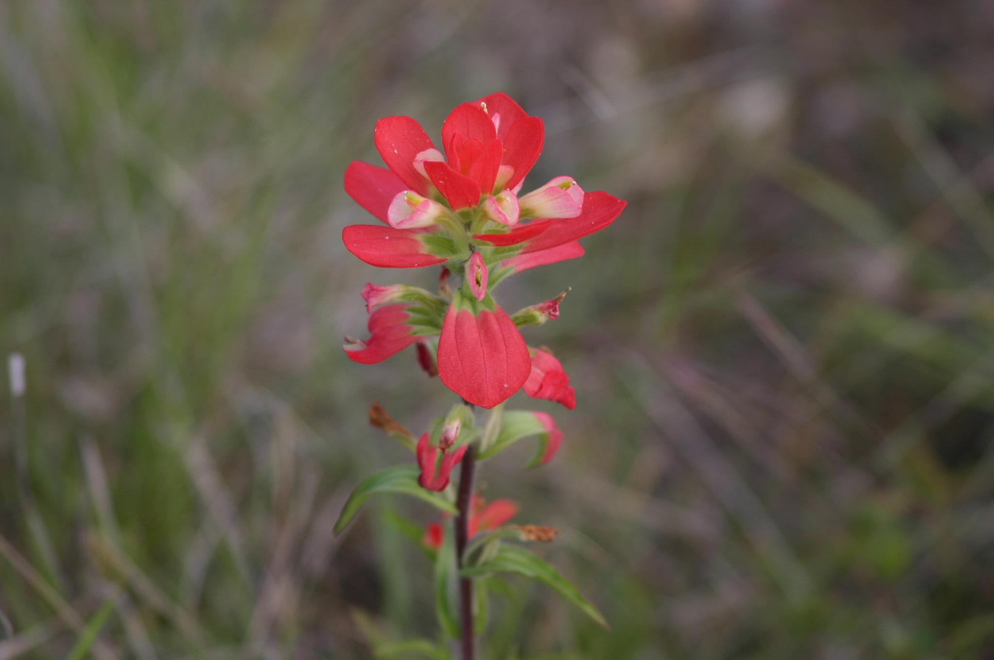
Castilleja indivisa
Indian Paintbrush, taken along Gorman Creek Trail -

Asclepias asperula
Antelope Horns, taken along Gorman Creek Trail
See also
- Colorado River (Texas)
- Texas Hill Country
- Balcones Canyonlands National Wildlife Refuge
External links
- http://www.tpwd.state.tx.us/spdest/findadest/parks/colorado_bend/
- Facilities Map of Colorado Bend State Park
- Event Schedules of Colorado Bend State Park
Coordinates: 31°3′14″N 98°29′32″W / 31.05389°N 98.49222°W
Protected Areas of Texas Federal El Orcoquisac Archeological District · Fort Davis National Historic Site · Lyndon B. Johnson National Historical Park · Palo Alto Battlefield National Historical Park · San Antonio Missions National Historical ParkAnahuac · Aransas · Attwater Prairie Chicken · Balcones Canyonlands · Big Boggy · Brazoria · Buffalo Lake · Grulla · Hagerman · Laguna Atascosa · Lower Rio Grande Valley · McFaddin · Muleshoe · San Bernard · Santa Ana · Texas Point · Trinity RiverState Abilene · Atlanta · Balmorhea · Barton Warnock Environmental Education Center · Bastrop · Bentsen-Rio Grande Valley · Big Bend Ranch · Big Spring · Blanco · Boca Chica · Bonham · Brazos Bend · Buescher · Caddo Lake · Caprock Canyons · Cedar Hill · Choke Canyon · Cleburne · Colorado Bend · Cooper Lake · Copper Breaks · Daingerfield · Davis Mountains · Devils River State Natural Area · Devil's Sinkhole State Natural Area · Dinosaur Valley · Eisenhower · Enchanted Rock State Natural Area · Estero Llano Grande · Fairfield Lake · Falcon · Fort Boggy · Fort Parker State Park · Fort Richardson State Park · Franklin Mountains · Galveston Island · Garner · Goliad · Goose Island · Government Canyon State Natural Area · Guadalupe River · Hill Country State Natural Area · Honey Creek State Natural Area · Huntsville · Indian Lodge · Inks Lake · Kickapoo Cavern · Lake Arrowhead · Lake Bob Sandlin · Lake Brownwood · Lake Casa Blanca International · Lake Colorado City · Lake Corpus Christi · Lake Livingston · Lake Mineral Wells · Lake Somerville · Lake Tawakoni · Lake Texana · Lake Whitney · Lockhart · Longhorn Cavern · Lost Creek Reservoir State Trailway · Lost Maples State Natural Area · Martin Creek Lake · Martin Dies, Jr. · Matagorda Island · McKinney Falls · Meridian · Mission Tejas · Monahans Sandhills · Mother Neff State Park · Mustang Island · Palmetto · Palo Duro Canyon · Pedernales Falls · Possum Kingdom · Purtis Creek · Ray Roberts Lake · Resaca de la Palma · San Angelo · Sea Rim · Sheldon Lake · South Llano River · Stephen F. Austin · Tyler · Village Creek · Walter Umphrey · Wyler Aerial TramwayActon · Admiral Nimitz · Barrington Living History Farm at Washington-on-the-Brazos · Battleship TEXAS · Caddoan Mounds · Casa Navarro · Confederate Reunion Grounds · Eisenhower Birthplace · Fanthorp Inn · Fannin Battleground · Fort Griffin · Fort Lancaster · Fort Leaton · Fort McKavett · Fort Richardson · Fulton Mansion · Goliad · Hueco Tanks · Kreische Brewery · Landmark Inn · Levi Jordan Plantation · Lipantitlan · Lyndon B. Johnson · Magoffin Homestead · Mission Espiritu Santo · Mission Rosario · Monument Hill · Penn Farm · Point Isabel Lighthouse · Sabine Pass Battleground · Sam Bell Maxey House · Samuel T. Rayburn House · San Felipe · San Jacinto Battleground · Sauer-Beckmann Farm · Sebastopol House · Seminole Canyon · Starr Family Home · Varner–Hogg Plantation · Washington-on-the-Brazos · Zaragosa BirthplaceState Wildlife TrailsGreat Texas Coastal · Heart of Texas · Panhandle Plains · Prairies and PineywoodsTexas Parks and Wildlife Department Categories:- Texas state parks
- Protected areas of San Saba County, Texas
- Protected areas of Lampasas County, Texas
- Texas protected area stubs
-


Wikimedia Foundation. 2010.