- Montgomery Township, Montgomery County, Pennsylvania
-
For other Pennsylvania townships of the same name, see Montgomery Township, Pennsylvania.
Montgomery Township Township  The Joseph Ambler Inn
Country United States State Pennsylvania County Montgomery Elevation 433 ft (132 m) Coordinates 40°15′03″N 75°15′05″W / 40.25083°N 75.25139°W Area 10.7 sq mi (27.7 km2) - land 10.7 sq mi (28 km2) - water 0.0 sq mi (0 km2), 0% Population 24,790 (2010) Density 2,067.1 / sq mi (798.1 / km2) Timezone EST (UTC-5) - summer (DST) EDT (UTC-4) Area code 215  Location of Montgomery Township in Montgomery County
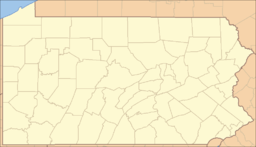
 Location of Montgomery Township in Pennsylvania
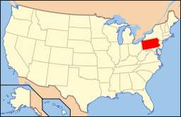 Location of Pennsylvania in the United States
Website: http://www.montgomerytwp.org Montgomery Township is a township in Montgomery County, Pennsylvania, United States. The population was 24,790 at the 2010 census.[1] It is the location of the Montgomery Mall, a regional shopping mall serving the Route 309 corridor of the Philadelphia suburbs. Much of Montgomery Township's development is suburban in character, with newer tract houses and strip shopping centers. Homes in Montgomery Township have North Wales and Lansdale (even though the township is distinct from those boroughs) addresses, but businesses that are located within the township boundaries are given the Montgomeryville zip code. The township is in the North Penn School District. It is the birthplace of Civil War general Winfield Scott Hancock.
Contents
Geography
According to the United States Census Bureau, the township has a total area of 10.7 square miles (27.6 km²), all of it land. It is in the Delaware watershed and is drained mainly by the Little Neshaminy Creek. Its villages include Christy (also in Bucks County,) Colmar (also in Hatfield Township,) Eureka (also in Bucks County and Horsham Township,) Fortuna (also in Hatfield Township,) Montgomery Square, and Montgomeryville.
Neighboring municipalities
- Horsham Township (southeast)
- Lower Gwynedd Township (south)
- Upper Gwynedd Township (southwest)
- Lansdale (west)
- Hatfield Township (northwest)
- New Britain Township, Bucks County (north)
- Warrington Township, Bucks County (northeast)
Demographics
Historical populations Census Pop. %± 1930 850 — 1940 951 11.9% 1950 1,566 64.7% 1960 2,700 72.4% 1970 3,936 45.8% 1980 5,718 45.3% 1990 12,179 113.0% 2000 22,025 80.8% 2010 24,790 12.6% www.dvrpc.org/data/databull/rdb/db82/appedixa.xls.</ref> As of the 2010 census, the township was 76.7% White, 4.6% Black or African American, 0.1% Native American, 16.6% Asian, and 1.6% were two or more races. 2.2% of the population were of Hispanic or Latino ancestry [1].
As of the census[1] of 2000, there were 22,025 people, 7,926 households, and 6,055 families residing in the township. The population density was 2,067.1 people per square mile (797.7/km²). There were 8,053 housing units at an average density of 755.8/sq mi (291.7/km²). The racial makeup of the township was 85.60% White, 3.87% African American, 0.07% Native American, 9.19% Asian, 0.01% Pacific Islander, 0.28% from other races, and 0.98% from two or more races. Hispanic or Latino of any race were 1.27% of the population.
There were 7,926 households out of which 39.9% had children under the age of 18 living with them, 68.5% were married couples living together, 5.9% had a female householder with no husband present, and 23.6% were non-families. 19.7% of all households were made up of individuals and 6.5% had someone living alone who was 65 years of age or older. The average household size was 2.74 and the average family size was 3.20.
In the township the population was spread out with 28.4% under the age of 18, 4.0% from 18 to 24, 34.5% from 25 to 44, 21.8% from 45 to 64, and 11.3% who were 65 years of age or older. The median age was 37 years. For every 100 females there were 93.3 males. For every 100 females age 18 and over, there were 89.2 males.
The median income for a household in the township was $78,953, and the median income for a family was $88,209 (these figures had risen to $84,026 and $102,174 respectively as of a 2007 estimate[2]). Males had a median income of $61,260 versus $40,858 for females. The per capita income for the township was $32,349. About 1.5% of families and 2.0% of the population were below the poverty line, including 1.5% of those under age 18 and 3.7% of those age 65 or over.
Government and Politics
Presidential elections results Year Republican Democrat 2008 42.9% 5,557 56.5% 7,316 2004 48.9% 5,946 50.8% 6,173 2000 49.1% 4,870 48.7% 4,829 1996 44.2% 3,589 45.8% 3,715 1992 43.9% 3,031 35.8% 2,468 References
- ^ a b "American FactFinder". United States Census Bureau. http://factfinder.census.gov. Retrieved 2008-01-31.
- ^ http://factfinder.census.gov/servlet/ACSSAFFFacts?_event=Search&geo_id=06000US4209145080&_geoContext=01000US%7C04000US42%7C05000US42091%7C06000US4209145080&_street=&_county=montgomery+township&_cityTown=montgomery+township&_state=04000US42&_zip=&_lang=en&_sse=on&ActiveGeoDiv=geoSelect&_useEV=&pctxt=fph&pgsl=060&_submenuId=factsheet_1&ds_name=ACS_2007_3YR_SAFF&_ci_nbr=null&qr_name=null®=null%3Anull&_keyword=&_industry=
External links
Categories:- Townships in Montgomery County, Pennsylvania


Wikimedia Foundation. 2010.