- Rollins Pass
-
Coordinates: 39°56.0′N 105°41.0′W / 39.933°N 105.683°W
Rollins Pass 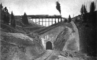

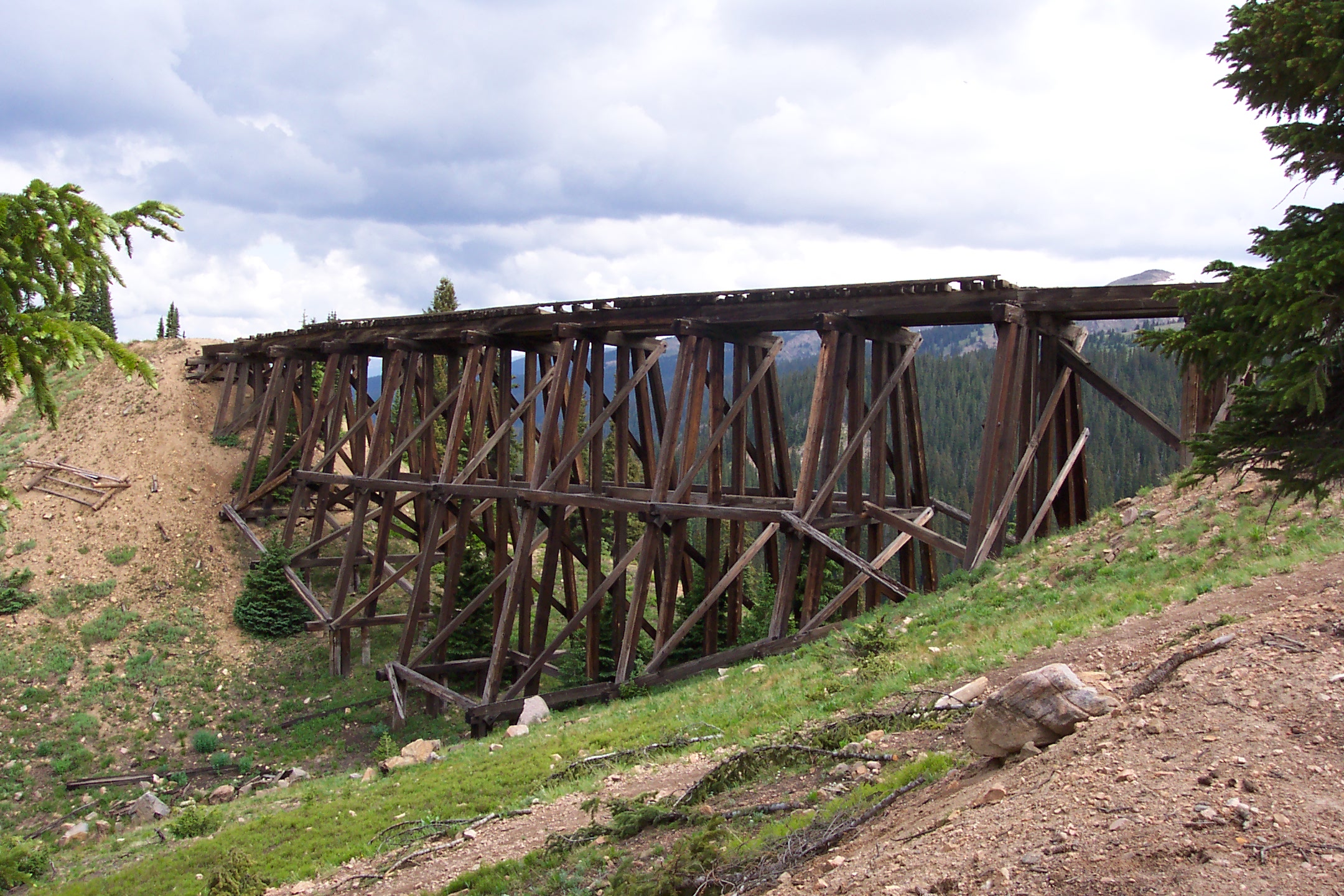
Riflesight Notch railroad trestle on the way up Rollins Pass; 1903 above, 2006 belowElevation 11,660 ft (3,554 m) Traversed by Unpaved road, natural gas pipeline Location Location Boulder / Grand counties, Colorado, USA Range Rocky Mountains Coordinates 39°56.0′N 105°41.0′W / 39.933°N 105.683°W Topo map USGS topo map Rollins Pass (el. 11,660 ft) is a high mountain pass in the Rocky Mountains of north-central Colorado in the United States. The pass is located on the continental divide at the crest of the Front Range southwest of Boulder, at the boundary of Grand and Boulder counties.
Contents
Description
Rollins Pass (a.k.a. Corona Pass) sits approximately 5 miles east and above the popular ski areas around Winter Park, between Winter Park and Rollinsville. The pass is traversed by two unpaved roads, mostly the former roadbed of the Denver and Salt Lake Railway which abandoned the route in 1928 when the Moffat Tunnel opened to replace it. This high altitude railroad was known as the Moffat Road. The Boulder Wagon Road, which predates the rail route, also uses Rollins Pass to cross the Continental Divide.
The majority of the route of the Moffat Road is open, except for a long, deteriorated trestle just east of the pass, and sections leading to the Needle's Eye Tunnel, a short high altitude railroad tunnel which was closed in 1990 after a rock fell from the ceiling injuring a Denver firefighter. Since then, the tunnel was sealed by Boulder County and the USFS. The original Boulder Wagon Road (BWR) also goes over Rollins Pass and bypasses the Needles Eye Tunnel. The BWR is a four-wheel-drive road not suited to lower clearance two-wheel-drive vehicles. Although open prior to 2008 and in good condition, this road remains to this day a subject of much controversy between its users and some officials who want it closed. In 2002 the James Peak Wilderness and Protection Area Bill (aka Public Law 107-216) was signed into legislation by President George W. Bush and Congress. The Bill specifically created a narrow road corridor between the Indian Peaks and James Peaks Wilderness areas and states that if any of the affected counties (Grand, Gilpin or Boulder) request, the Secretary of the USDA will cooperate and assist with the repair of the Rollins Pass Road and until that time the attendant road (the BWR) will remain open to motorized use. Boulder County officials and the USFS-Boulder Ranger District have resisted the wording of the law and have closed the BWR. Both Grand and Gilpin Counties have made numerous written requests to the Secretary for the repair of Rollins Pass Road but to date there has been no repair of the road or the barricaded Needles Eye Tunnel. The reopening of the BWR, and/or repair of the Rollins Pass Road, and even the facts surrounding the 1990 accident in the tunnel, have become contentious and ongoing issues.
 2006 photo of the Needle's Eye Tunnel near the top of Rollins Pass showing it in good condition.
Rollins pass is a popular recreational location for its spectacular views, wildflowers, hiking, photography, and high clearance vehicles during the summer months. The road up to the pass on the western side from Winter Park is in good condition starting from US Route 40 in Winter Park, and can be traveled by regular 2wd automobile in the summer in good weather, or by snowmobile in the winter.
The only access to the actual Rollins Pass from the east is via the disputed 4wd BWR due to the tunnel closure. From the Peak-to-Peak Highway (State Highway 119) at Rollinsville East Portal Road runs west, parallel to South Boulder Creek and the current Union Pacific Railroad tracks, to the entrance to the Moffat Tunnel at East Portal, and then rises on the abandoned railroad grade via the Moffat Road to the closed Needle's Eye Tunnel. From Rollinsville to East Portal, the road is an all-weather gravel road which can be traveled by regular automobiles. However, beyond East Portal it is very rough due to lack of maintenance. Although not steep or loose, it is recommended that a high clearance 4wd vehicle be used. This section of road is open to just beyond Jenny Lake where there is a barricade approximately one half mile before the Needles Eye Tunnel. The road is open for hiking beyond the barricade to the entrance of the closed tunnel, and a rough trail continues above the tunnel for those on foot to bypass the closure.
 Sign that sits on top of Rollins Pass
The pass provides a route over the Continental Divide between the Atlantic Ocean watershed of South Boulder Creek (in the basin of the South Platte River) with the Pacific Ocean watershed of the Fraser River, a tributary of the Colorado River. Native Americans were the first travelers over Rollins Pass which is a natural low crossing over the Continental Divide and beyond. The first recorded use of the pass by a wagon train was in 1862. It is named for John Rollins, who constructed a toll wagon road over the pass in the 1870s, providing a route between the Colorado Front Range and Middle Park. The pass was used heavily in the late 19th century by settlers to drive cattle over the continental divide to Middle Park, and at one time as many as 12,000 cattle at a time were driven over the pass [1].
Rollins Pass as a railroad line
In the early 20th century, David Moffat, a Denver banker, established the Denver, Northwestern and Pacific Railway with the intention of building a railroad over the Front Range in the vicinity of the pass. The line was known as the Moffat Road, ran 23 miles over the pass, with a 4% grade along many stretches, and was one of the highest adhesion (non-cog) railroads ever constructed in North America. Along this route is the closed Needles Eye Tunnel (not to be confused with lower and longer Moffat Tunnel constructed some 30 years later). Other notable landmarks on the route included Riflesight Notch, a loop where trains crossed over a trestle, went through a loop, and passed through a tunnel underneath the trestle. A small rail stop called Corona was established at the top of the pass, with a restaurant and lodging, which allowed workers to help keep the rail line free of snow in the winter. Despite the fact that the line was enclosed in almost continuous sheds near the top of the pass, trains were often stranded for several days during heavy winter snowstorms because the snow could fall through the wood planking of the sheds. It was these heavy snowstorms that were the demise of the Moffat Road and the incentive for construction of a tunnel. Because the route was intended to be a temporary, it was constructed as cheaply as possible - using high trestles, 4% grades and switchbacks instead of high fills, iron bridges, and tunnels. Because of the high-altitude nature of the route, the route utilized wyes instead of turntables to turn locomotives around.
Much of the right-of-way is still intact, although some of the trestles have collapsed. A small wye on the passing siding at the eastern portal of the Moffat Tunnel marks the spot where the Rollins Pass line would have merged into the modern route if it still existed. This wye is currently utilized for short-turning some services.
The first attempt to tunnel under Rollins Pass met with both engineering and financial failure, and its remains can still be seen at Yankee Doodle Lake. The second attempt, to built a longer tunnel at a lower elevation, was better planned and financed. Although Moffat did not live to see his tunnel completed, his enterprise was continued under a different name, and the Moffat Tunnel opened just south of the pass on February 26, 1928. The new tunnel route became part of the mainline across Colorado of the Denver and Salt Lake Railroad, later the Denver and Rio Grande Railroad, and now the Union Pacific Railroad. The Moffat Tunnel continues to serve as the route for the Amtrak California Zephyr between Chicago, Illinois and Emeryville, California, and until summer 2009, for Ski Train passengers between Denver and Winter Park.
The Rollins Pass tracks were not immediately demolished after the tunnel opened. In fact, they had to remain usable as an emergency route. It was used as such in July of 1928 when several wooden planks inside the tunnel collapsed. Permission to rip up the rails on Rollins Pass was not granted by the ICC until 1935. Sometime in the seven years between when the line was abandoned and when the tracks were ripped up, a mysterious fire destroyed several of the snowsheds near the summit and the hotel at Corona.
Recent events
On July 30, 2006, a single engine airplane on its way to Boulder crashed on Rollins Pass. The two occupants of the 1969 Citabria 7KCAB were killed on impact. [2]
References
External links
Categories:- Rail mountain passes of the United States
- Mountain passes of Colorado
- Geography of Boulder County, Colorado
- Geography of Grand County, Colorado
- Denver and Rio Grande Western Railroad
- Visitor attractions in Boulder County, Colorado
- Visitor attractions in Grand County, Colorado


Wikimedia Foundation. 2010.