- Middlezoy
-
Coordinates: 51°05′17″N 2°53′38″W / 51.088°N 2.894°W
Middlezoy 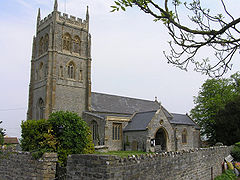
Church of the Holy Cross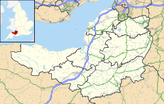
 Middlezoy
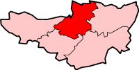
Middlezoy shown within SomersetPopulation 720 [1] OS grid reference ST375325 District Sedgemoor Shire county Somerset Region South West Country England Sovereign state United Kingdom Post town BRIDGWATER Postcode district TA7 Dialling code 01278 Police Avon and Somerset Fire Devon and Somerset Ambulance South Western EU Parliament South West England List of places: UK • England • Somerset Middlezoy is a village and civil parish on the River Parrett as it crosses the Somerset Levels in the Sedgemoor district of Somerset, England.
Contents
History
The name Middlezoy meaning the middle stream island, derives from Sowi, the name of Glastonbury Abbey's major estate, sow being a British river name from a root meaning flowing. The extra i being derived from the Saxon ig for island.[2]
The parish of Middlezoy was part of the Whitley Hundred.[3]
On 1800 1,100 acres of common land were enclosed as a result of the Inclosure Acts.[4]
In 2006 the village shop closed and grant was obtained for the erection of a new modular structure to house a community shop and post office.[5]
Governance
The parish council has responsibility for local issues, including setting an annual precept (local rate) to cover the council’s operating costs and producing annual accounts for public scrutiny. The parish council evaluates local planning applications and works with the local police, district council officers, and neighbourhood watch groups on matters of crime, security, and traffic. The parish council's role also includes initiating projects for the maintenance and repair of parish facilities, as well as consulting with the district council on the maintenance, repair, and improvement of highways, drainage, footpaths, public transport, and street cleaning. Conservation matters (including trees and listed buildings) and environmental issues are also the responsibility of the council.
The village falls within the Non-metropolitan district of Sedgemoor, which was formed on April 1, 1974 under the Local Government Act 1972, having previously been part of Bridgwater Rural District,[6] which is responsible for local planning and building control, local roads, council housing, environmental health, markets and fairs, refuse collection and recycling, cemeteries and crematoria, leisure services, parks, and tourism.
Somerset County Council is responsible for running the largest and most expensive local services such as education, social services, libraries, main roads, public transport, policing and fire services, trading standards, waste disposal and strategic planning.
It is also part of a county constituency represented in the House of Commons of the Parliament of the United Kingdom. It elects one Member of Parliament (MP) by the first past the post system of election, and part of the South West England constituency of the European Parliament which elects seven MEPs using the d'Hondt method of party-list proportional representation.
Geography
Just to the north of the village is the Greylake Site of Special Scientific Interest, which consists of 20 low-lying fields in the north west corner of King's Sedgemoor,[7] and includes the Royal Society for the Protection of Birds Greylake nature reserve.[8] This location is the type section for the Pleistocene Burtle Beds, as it is the is probably the most complete Burtle Beds sequence in Somerset. It demonstrates a sequence of fluvial (or possibly glacial) gravels, marine intertidal silts and marine subtidal. Rich molluscan, ostracod and foraminifer assemblages and a mammalian fauna, including Red Deer (Cervus elephus), Aurochs (Bos primigenius) and Fallow Deer (Dama cf dama) have been recorded.[9]
Religious sites
The Church of the Holy Cross dates from the 13th century. It has a 3-stage tower similar to that at Lyng and has been designated by English Heritage as a grade I listed building.[10] William of Bitton II was the rector by 20 April 1263.[11]
References
- ^ "Parish Population Statistics for Sedgemoor". ONS Census 2001. Somerset County Council. http://www.webcitation.org/5lRyCSu4c. Retrieved 2009-12-17.
- ^ Bush, Robin (1994). Somerset: The complete guide. Wimborne: The Dovecote Press Ltd. pp. 143. ISBN 1874336261.
- ^ "Somerset Hundreds". GENUKI. http://www.genuki.org.uk/big/eng/SOM/Miscellaneous/. Retrieved 22 October 2011.
- ^ Havinden, Michael (1982). The Somerset Landscape. The making of the English landscape. London: Hodder and Stoughton. pp. 133. ISBN 0340201169.
- ^ "Middlezoy community post office/shop". Somerset Rural Renaissance. http://www.somerset-rural-renaissance.co.uk/projects-middlezoy-community-post-office.html. Retrieved 14 May 2010.
- ^ A Vision of Britain Through Time : Bridgwater Rural District
- ^ "RSPB Greylake". Attractions in Somerset. http://www.visitsomerset.co.uk/site/things-to-do/attractions/rspb-greylake-p666003map.
- ^ "Greylake". Resereves. RSPB. http://www.rspb.org.uk/reserves/guide/g/greylake/.
- ^ English Nature citation sheet for the site (accessed 7 August 2006)
- ^ "Church of the Holy Cross". Images of England. http://www.imagesofengland.org.uk/details/default.aspx?id=269550. Retrieved 2008-02-03.
- ^ British History Online Archdeacons of Wells accessed on 23 September 2007
External links
 Media related to Middlezoy at Wikimedia Commons
Towns, villages and hamlets in the Sedgemoor district of Somerset, England  Ashcott · Axbridge · Badgworth · Bawdrip · Berrow · Brean · Brent Knoll · Bridgwater · Broomfield · Burnham-on-Sea · Burtle · Cannington · Catcott · Chapel Allerton · Cheddar · Chedzoy · Chilton Polden · Chilton Trinity · Compton Bishop · Cossington · Durleigh · East Brent · Huntspill · Edington · Edithmead · Enmore · Fiddington · Goathurst · Greinton · Highbridge · Lympsham · Lyng · Mark · Middlezoy · Moorlinch · Nether Stowey · North Petherton · Othery · Otterhampton · Over Stowey · Pawlett · Puriton · Shapwick · Shipham · Spaxton · Stawell · Stockland Bristol · Thurloxton · Weare · Wedmore · Wembdon · Westonzoyland · WoolavingtonCategories:
- Villages in Sedgemoor
- Civil parishes in Somerset


Wikimedia Foundation. 2010.