- Mijanès
-
Mijanès

 Mijanès
Administration Country France Region Midi-Pyrénées Department Ariège Arrondissement Foix Canton Quérigut Intercommunality Donezan Mayor Christian Dubuc
(2008–2014)Statistics Elevation 1,037–2,541 m (3,402–8,337 ft)
(avg. 1,130 m/3,710 ft)Land area1 39.95 km2 (15.42 sq mi) Population2 92 (2008) - Density 2 /km2 (5.2 /sq mi) INSEE/Postal code 09193/ 09460 1 French Land Register data, which excludes lakes, ponds, glaciers > 1 km² (0.386 sq mi or 247 acres) and river estuaries. 2 Population without double counting: residents of multiple communes (e.g., students and military personnel) only counted once. Coordinates: 42°43′54″N 2°03′25″E / 42.7316666667°N 2.05694444444°E
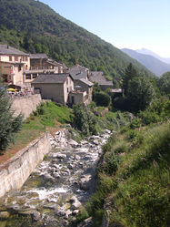
Mijanès is a commune in the Ariège department in southwestern France. It is located close to two Cathar castles, the Château d'Usson and the Château de Quérigut.
During World War II, the villagers of Mijanès were involved in the rescue of six British airmen of the Royal Air Force after their plane crashed on the Pic de la Camisette, a nearby mountain, in December 1944.[1] Wreckage of the plane is displayed today at the Château d'Usson.[2]
Population
Historical population of Mijanès 1962 1968 1975 1982 1990 1999 2008 57 91 71 75 79 78 92 See also
References
- ^ "Avion de la Camistte" (in French). Mijanes, notre Village. http://mijanes.pagesperso-orange.fr/avion.htm. Retrieved 16 September 2011.
- ^ "Photo: Moteur de l'avion anglais tombé au Pic de la Camisette en décembre 1944". Visite de la Maison du Patrimoine du Donezan. http://www.donezan.com/diaporamas/mpd/index.html. Retrieved 16 September 2011.
Categories:- Communes of Ariège
- Ariège geography stubs


Wikimedia Foundation. 2010.