- 1928 Okeechobee hurricane
-
1928 Okeechobee Hurricane
San Felipe Segundo HurricaneCategory 5 hurricane (SSHS) 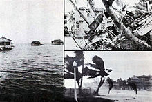
1928 Okeechobee hurricane Formed September 6, 1928 Dissipated September 20, 1928 Highest winds 1-minute sustained:
160 mph (260 km/h)Lowest pressure ≤ 929 mbar (hPa; 27.43 inHg) Fatalities 4,078+ Damage $100 million (1928 USD) Areas affected Lesser Antilles, Guadeloupe, Virgin Islands, Puerto Rico, Bahamas, Florida, Georgia, South Carolina, North Carolina, Eastern Seaboard Part of the 1928 Atlantic hurricane season The Okeechobee hurricane, or San Felipe Segundo hurricane, was a deadly hurricane that struck the Leeward Islands, Puerto Rico, the Bahamas, and Florida in September of the 1928 Atlantic hurricane season. It was the second recorded hurricane to reach Category 5 status on the Saffir-Simpson Hurricane Scale in the Atlantic basin after the 1924 Cuba hurricane; as of 2010, it remained the only recorded hurricane to strike Puerto Rico at Category 5 strength, and one of the ten most intense ever recorded to make landfall in the United States.
The hurricane caused devastation throughout its path. As many as 1,200 people were killed in Guadeloupe. The storm directly struck Puerto Rico at peak strength, killing at least 300 and leaving hundreds of thousands homeless. In South Florida at least 2,500 were killed when a storm surge from Lake Okeechobee breached the dike surrounding the lake, flooding an area covering hundreds of square miles.[1] In total, the hurricane killed at least 4,078 people and caused around US$100 million ($1.28 billion 2011 USD) in damages over the course of its path.
Contents
Meteorological history
 Storm path
The storm was first observed 900 miles (1450 km) to the east of Guadeloupe on September 10 by the S.S. Commack. At the time, this was the most easterly report of a tropical cyclone ever received through ship's radio.[2] A Cape Verde-type hurricane, hurricane analysis in the 1990s determined the storm likely formed four days prior between Cape Verde and the coast of Africa.[3]
As the storm neared the Caribbean, it was already a Category 3 hurricane.[3] On September 12 it passed over Guadeloupe and then south of the other Leeward Islands; Guadeloupe reported a pressure of 27.76 inHg (940 mbar), and a ship just south of St. Croix in the United States Virgin Islands reported it as an even stronger storm with a pressure of 27.50 inHg (931 mbar).[2] On the 13th the storm struck Puerto Rico directly as a Category 5 hurricane, allegedly packing winds of 160 mph (260 km/h);[3] reliable reports from San Juan placed the wind speed at 125 knots (145 mph, 230 km/h), and a report from Guayama placed the pressure at 27.65 inHg (936 mbar).[2] The 160 mph (260 km/h) wind measurement from Puerto Rico was taken by a cup anemometer in San Juan, 30 miles (50 km) north of the storm's center, which measured 160 mph (260 km/h) sustained winds three hours before the peak wind speed was reached; however, the instrument was destroyed soon after and could not be calibrated. This unverified reading was the strongest wind measurement ever reported for an Atlantic hurricane up until that time; not until Hurricane Dog of 1950 were stronger winds officially measured in an Atlantic storm, although some unmeasured storms like the 1935 Labor Day Hurricane may have been stronger.[3] Because of this measurement, the Okeechobee storm was the first hurricane, in the Atlantic basin known to have reached Category 5 intensity, although in 2009, it was found that the 1924 Cuba Hurricane had reached Category 5 as well; although it is virtually certain that earlier hurricanes had achieved this strength (a likely candidate is the Great Havana Hurricane of 1846), none had ever had their winds or pressure recorded properly.[citation needed]
The hurricane was also extremely large as it crossed Puerto Rico. Hurricane-force winds were measured in Guayama for 18 hours; since the storm is estimated to have been moving at 13 mph (21 km/h), the diameter of the storm's hurricane winds was estimated very roughly to be 234 miles (376 km).[4] After leaving the Caribbean, the hurricane moved across the Bahamas as a strong Category 4 hurricane. It continued to the west-northwest, and made landfall in southern Florida on the evening of September 16 (or early on September 17 Universal Time).[3] Initially, Richard Gray of the U.S. Weather Bureau was optimistic that the storm would spare the south Florida region.[5] Atmospheric pressure at landfall was measured at 929 mbar (hPa),[6] and maximum sustained winds were near 150 mph (240 km/h).[3] The eye passed ashore in Palm Beach County near West Palm Beach, then moved directly over Lake Okeechobee.[3] Peak gusts were estimated near 160 mph (260 km/h) at Canal Point, Florida.[2] The hurricane's path turned northeast as it crossed Florida, taking it across northern Florida, eastern Georgia, and the Carolinas on September 19. It then moved inland and merged with a low-pressure system around Toronto on the 20th.[3]
Impact
Leeward Islands
Storm Deaths by Region Region Deaths Locale Deaths Caribbean
and Bahamas1575[7] Martinique 3 Guadeloupe 600–1200 Montserrat 42[8] Nevis 3[9] Puerto Rico 312 Bahamas 18 United States 2500+[10] Florida 2500+ Total 4078+ The hurricane moved directly over the Leeward Islands in the Caribbean, strengthening as it did so. On the island of Dominica winds were clocked at 24 mph (39 km/h); there were no reports of damages.[2] In Martinique, even further south of the storm's path, there were three fatalities.[7] Guadeloupe received a near-direct hit from the storm, apparently with little warning; the death toll there was 600–1200,[7] and damage reports relayed through Paris indicated "great destruction" on the island.[2]
Montserrat, just north of the storm's center, was warned in advance of the storm but still suffered £150,000 (1928 UKP) in damages and 42 deaths; Plymouth and Salem were devastated and crop losses caused near-starvation conditions before relief could arrive.[8] The storm passed to the south of the islands of St. Kitts and St. Croix, which suffered heavy damages to property and crops but no reported fatalities.[2] Nevis did report three deaths due to the storm, though.[9] Damage reports from elsewhere in the Leeward Islands are not available.
Puerto Rico
 Hurricane-force winds drove this 10-ft (3 m) 2x4 through a palm tree in Puerto Rico
The island of Puerto Rico received the worst of the storm's winds when the hurricane moved directly across the island at Category 5 strength. The island knew of the storm's approach well ahead of time; by about 36 hours in advance all police districts were warned and radio broadcasts provided constant warnings to ships. Effective preparation is credited for the relatively low death toll of 312, and not a single ship was lost at sea in the vicinity of Puerto Rico. By comparison, the weaker 1899 Hurricane San Ciriaco killed approximately 3,000 people.[4]
The storm was named the San Felipe II Hurricane because the eye of the cyclone made landfall on the Christian feast day of Saint Philip.[11] It was named "Segundo", Spanish for "the Second", because of another destructive "Hurricane San Felipe" which struck Puerto Rico on that same day in 1876.[12] Since European arrival in the Americas in 1492 all storms and hurricanes were named after the name of the saint of the day the storm hit Puerto Rico.[13] In 1953 that the United States started naming hurricanes by female names until 1978 when both gender names began to be used.[13] Yet it was only in 1960 that hurricanes stopped being officially named after Saints.[13]
San Felipe II is officially classified as Puerto Rico's biggest, worst, and most devastating hurricane to ever have impacted the island.[11] Even though it was the worst hurricane to hit the island, others such as the San Ciriaco Hurricane caused more deaths. The first warning the Island received was by the steamship Commack on latitude 17° north and longitude 48° West. San Felipe entered the island early in the morning of Thursday September 13, with its eye close to Guayama and it traversed the island in a north-west direction, leaving between the towns of Aguadilla and Isabela. The eye of the hurricane made its Puerto Rico crossing in eight hours, moving at about 13 mph (21 km/h). In Guayama, located in south eastern Puerto Rico, the lowest recording of the storm was taken; 27.5 inHg (930 mbar) at 2:30 p.m.[11]
Rainfall
The rain on the 13 and 14 of September 1928, are the record holders for the maximum of rainfall associated with a hurricane in Puerto Rico in a period of forty-eight hours.[11] In those regions where precipitation is more common place, as in Adjuntas in the Cordillera Central and in the Sierra de Luquillo, the rain was over 25 inches (640 mm), with 29.60 inches (752 mm) recorded in Adjuntas.[11]
Wind
The anemometer located in Puerta de Tierra lost one of its cups at 11:44 a.m. on the September 13, just when it had registered a maximum speed of 150 miles (240 km) per hour, a speed that was sustained for five consecutive minutes. Previously the same instrument had measured 160 miles (260 km) per hour for one minute.[11] The city of San Juan was 30 miles (48 km) away from the eye of San Felipe when those measurements were recorded. Because of which it seems probable that some estimates of 200 miles (320 km) per hour in the center of the storm might not seem so farfetched.[11]
Damages
There was general destruction through the island, with the towns where the eye passed being swept away.[11] Property damage on the island from winds and rain was catastrophic. The northeast portion of the island received winds in excess of Category 3 strength, with hurricane-force winds lasting as long as 18 hours. Official reports stated "several hundred thousand" people were left homeless, and property damages were estimated at $50 million ($641 million 2011 USD)).[4][14]
In the island there was no building that was not affected.[11] Some sugar mills ("Centrales") that had cost millions of dollars to build were reduced to rubble. Reports say that 24,728 homes were completely destroyed and 192,444 were partially destroyed.[11] Most of the sugarcane fields were flooded, thus losing the year's crops. Half of the coffee plants and half of the shade trees that covered these were destroyed; almost all of the coffee harvest was lost. The coffee industry would take years to recover since coffee needs shade trees to grow. The tobacco farms also had great losses. After this hurricane, Puerto Rico never regained its position as a coffee exporter.[15]
Communications were impacted by fallen trees, landslides, and debilitated bridges. Of the school buildings 770 were destroyed or debilitated. According to some estimates of the day, excluding personal losses, the damages reached ($1.09 billion 2011 USD)) and over 500,000 people were left homeless.[11]
Bahamas
Deadliest Atlantic hurricanes Rank Hurricane Season Fatalities 1 "Great Hurricane" 1780 22,000 2 Mitch 1998 19,325+ 3 "Galveston" 1900 8,000 – 12,000 4 Fifi 1974 8,000 – 10,000 5 "Dominican Republic" 1930 2,000 – 8,000 6 Flora 1963 7,186 – 8,000 7 "Pointe-à-Pitre" 1776 6,000+ 8 "Newfoundland" 1775 4,000 – 4,163 9 "Okeechobee" 1928 4,075+ 10 "Monterrey" 1909 4,000 See also: List of deadliest Atlantic hurricanes The eye of the hurricane passed just south of Grand Bahama as a strong Category 4 hurricane, again causing very heavy damage. According to a firsthand account from the island, it was the worst storm in memory to strike the area. As in Puerto Rico, however, authorities in the Bahamas were aware of the hurricane's passage well ahead of time, and preparations minimized the loss of life in the islands. The only report of fatalities was from a sloop lost at sea in the vicinity of Ambergris Cay with 18 on board.[2]
South Florida
Coastal damage in Florida near the point of landfall was catastrophic. Miami, well south of the point of landfall, escaped with very little damage; Hollywood and Fort Lauderdale suffered only slight damages. In Fort Lauderdale, numerous power lines and telephone wires were downed.[16] Northward, from Pompano Beach to Jupiter, buildings suffered serious damage from the heavy winds and 10 ft (3 m) storm surge, which was heaviest in the vicinity of Palm Beach; total coastal damages were estimated as "several million" dollars.[2] In West Palm Beach, more than 1,711 homes were destroyed, while the Jupiter Inlet Lighthouse's mortar was reportedly "squeezed ...like toothpaste" between the bricks during the storm, swaying the tower 17 inches (43 cm) off the base.[17] Because of well-issued hurricane warnings, residents were prepared for the storm, and the number of lives lost in the coastal Palm Beach area was only 26.[2]
 Aftermath of the hurricane in southern Florida
Inland, the hurricane wreaked much more widespread destruction along the more heavily populated coast of Lake Okeechobee. Residents had been warned to evacuate the low ground earlier in the day, but after the hurricane did not arrive on schedule, many thought it had missed and returned to their homes. When the worst of the storm crossed the lake—with winds measured on the ground at around 140 mph (225 km/h)—the south-blowing wind caused a storm surge to overflow the small dike that had been built at the south end of the lake. The resulting flood covered an area of hundreds of square miles with water that in some places was over 20 ft (6 m) deep. Houses were floated off of their foundations and dashed to pieces against any obstacle they encountered.[18] However, for the few families who resided on Torry Island, the breached dike saved their lives. The rising flood waters forced most families on to the roofs of their houses in an act of desperation. The dike's failure drained the lake and those on the island survived. Among the surviving on Torry Island were the families of Jesse Lee and Gus Cromartie. Meanwhile, most survivors and bodies were washed out into the Everglades where many of the bodies were never found. As the rear eyewall passed over the area, the flood reversed itself, breaking the dikes along the northern coast of the lake and causing a similar but smaller flood.
 Approximate area of the flood. Ironically, residents of Torry Island owe their survival to the resulting flood. Among those surviving were Jesse Lee and Gus Cromartie. Note: The Palm Beach County label is misplaced. North of Canal Point has been in Martin County since 1925.
Floodwaters persisted for several weeks, greatly impeding attempts to clean up the devastation. Burial services were quickly overwhelmed, and many of the bodies were placed into mass graves. Around 75% of the fatalities were migrant farm workers, making identification of both dead and missing bodies very difficult; as a result of this, the count of the dead is not very accurate. The Red Cross estimated the number of fatalities as 1,836, which was taken as the official count by the National Weather Service for many years (and exactly equal to the official count for Hurricane Katrina). Older sources usually list 3,411 as the hurricane's total count of fatalities, including the Caribbean. However, in 2003 the U.S. death count was revised as "at least" 2,500, making the Okeechobee hurricane the second-deadliest natural disaster in United States history behind the Galveston Hurricane of 1900. A mass grave at the Port Mayaca Cemetery east of Port Mayaca contains the bodies of 1,600 victims of the hurricane.[19]
Thousands of people were left homeless in Florida; property damage was estimated at $25 million ($321 million). It is estimated if a similar storm were to strike as of the year 2003, it would cause $18.7 billion in damages. The cyclone remains one of three Atlantic hurricanes to strike the southern mainland of Florida with a central pressure below 940 mbar (27.76 inHg), the others being the 1926 Miami hurricane and Hurricane Andrew of 1992.[20]
Elsewhere
Limited damage reports are available for the United States outside of southern Florida. The storm caused flooding in North Carolina and brought near-hurricane-force winds and a 7 foot (2.1 m) storm surge to the Norfolk area.[21] Nonetheless, most sources agree that the hurricane caused only minimal damage in these areas.[2]
Aftermath
Deadliest United States hurricanes Rank Hurricane Season Fatalities 1 "Galveston" 1900 8,000–12,000† 2 "Okeechobee" 1928 2,500+† 3 Katrina 2005 1,836 4 "Cheniere Caminada" 1893 1,100–1,400* 5 "Sea Islands" 1893 1,000–2,000† 6 "Florida Keys" 1919 778 7 "Georgia" 1881 700† 8 Audrey 1957 416 9 "Labor Day" 1935 408 10 "Last Island" 1856 400† Deadliest US hurricanes
†estimated totalRacial issues
In Florida, although the hurricane destroyed everything in its path with impartiality, the death toll was by far highest in the economically poor areas in the low-lying ground right around Lake Okeechobee. Around 75% of the fatalities were from migrant farm workers, most of whom were black. Black workers did most of the cleanup, and the few caskets available for burials were mostly used for the bodies of whites; other bodies were either burned or buried in mass graves. Burials were segregated, and the only mass gravesite to receive a memorial contained only white bodies.[22][23] The inequity has caused ongoing racial friction that still exists. The effects of the hurricane on black migrant workers is dramatized in Zora Neale Hurston's novel Their Eyes Were Watching God.
Improved building codes
In the aftermath of the hurricane in coastal Florida, it became apparent that well-constructed buildings with shutters had suffered practically no damage from winds that caused serious structural problems to lesser buildings. Buildings with well-constructed frames, and those made of steel, concrete, brick, or stone were largely immune to winds, and the use of shutters prevented damage to windows and the interior of the buildings. Coming on the heels of the 1926 Miami hurricane where a similar pattern had been noticed, one lasting result of the 1928 storm was improved building codes.[24]
Flood control
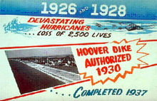 A sign advertising the completion of the Hoover Dike.
To prevent a recurrence of disasters like this one and the Great Miami Hurricane of 1926, the Florida State Legislature created the Okeechobee Flood Control District, which was authorized to cooperate with the U.S. Army Corps of Engineers in flood control undertakings.[25] After a personal inspection of the area by President Herbert Hoover, the Corps drafted a new plan which provided for the construction of floodway channels, control gates, and major levees along Lake Okeechobee's shores. A long term system was designed for the purpose of flood control, water conservation, prevention of saltwater intrusion, and preservation of fish and wildlife populations.[25] One of the solutions was the construction of the Herbert Hoover Dike. Today, concerns related to the dike's stability have grown in response to studies indicating long term problems with "piping" and erosion. Leaks have been reported after several heavy rain events. Proposed solutions to the dike's problems have included the construction of a seepage berm on the landward side of the dike, with the first stage costing approximately $67 million (USD).[26]
See also
- Hurricane of 1928 African American Mass Burial Site
- Port Mayaca, Florida Location of mass burial site of 1,600 Victims
- List of Atlantic hurricanes
- List of Category 5 Atlantic hurricanes
- List of Florida hurricanes
References
- ^ Christine Gibson (Aug./Sept. 2006). "Our 10 Greatest Natural Disasters". American Heritage. American Heritage Publishing. Archived from the original on 2010-04-03. http://web.archive.org/web/20081203144854/http://www.americanheritage.com/articles/magazine/ah/2006/4/2006_4_26.shtml. Retrieved 2011-07-23.
- ^ a b c d e f g h i j k Charles L. Mitchell (1928-12-08). "The West Indian Hurricane of September 10–20, 1928". Monthly Weather Review (American Meteorological Society) 56 (9): 347–350. Bibcode 1928MWRv...56..347M. doi:10.1175/1520-0493(1928)56<347:TWIHOS>2.0.CO;2. http://www.aoml.noaa.gov/general/lib/lib1/nhclib/mwreviews/1928.pdf. Retrieved 2010-04-29.
- ^ a b c d e f g h Hurricane Research Division (August 2011). "Atlantic hurricane best track (Hurdat)". National Oceanic and Atmospheric Administration. http://www.aoml.noaa.gov/hrd/hurdat/tracks1851to2010_atl_reanal.html. Retrieved 2011-09-19.
- ^ a b c Oliver L. Fassig (1928-12-08). "San Felipe–The Hurricane of September 13, 1928, at San Juan, P.R.". Monthly Weather Review (American Meteorological Society) 56 (9): 350–352. Bibcode 1928MWRv...56..350F. doi:10.1175/1520-0493(1928)56<350:SFHOSA>2.0.CO;2. http://docs.lib.noaa.gov/rescue/mwr/056/mwr-056-09-0350.pdf. Retrieved 2010-04-29.
- ^ Eliot Kleinberg (2003). Black Cloud: The Great Florida Storm of 1928. Carroll & Graf Publishers. p. 87. ISBN 978-0-7867-1146-8.
- ^ David A. Glenn (2005). "A Reanalysis of the 1916, 1918, 1927, 1928, and 1935 Tropical Cyclones of the North Atlantic Basin" (PDF). National Oceanic and Atmospheric Administration. http://www.aoml.noaa.gov/hrd/hurdat/GlennThesis.pdf. Retrieved 2008-01-13.
- ^ a b c National Hurricane Center (1995/1997). "The Deadliest Atlantic Tropical Cyclones, 1492–1996". National Oceanic and Atmospheric Administration. http://www.nhc.noaa.gov/pastdeadlyapp1.shtml. Retrieved 2008-01-14.
- ^ a b William G. Innanen. "A Condensed History of Montserrat". Archived from the original on February 12, 2006. http://web.archive.org/web/20060212185759/http%3A//innanen.com/montserrat/history/1920-1930.shtml%23h2. Retrieved 2006-02-27.
- ^ a b Hubbard, Vincent K. (2002). Swords, Ships & Sugar: History of Nevis. Corvallis, Oregon
- ^ Chris Landsea, NHC. "FAQ E12: For the USA, what are the 30 highest death toll hurricanes on record?". National Oceanic and Atmospheric Administration. http://www.aoml.noaa.gov/hrd/tcfaq/E12.html. Retrieved 2008-01-14.
- ^ a b c d e f g h i j k Mújica-Baker, Frank. "Huracanes y Tormentas que han afectado a Puerto Rico". Estado Libre Asociado de Puerto Rico, Agencia Estatal para el manejo de Emergencias y Administración de Desastres. pp. 10. http://www.gobierno.pr/NR/rdonlyres/49EA64D0-305B-4881-8B85-04B518004BD5/0/Ciclones_en_PR.pdf. Retrieved august 30, 2010.
- ^ Mújica-Baker, Frank. "Huracanes y Tormentas que han afectado a Puerto Rico". Estado Libre Asociado de Puerto Rico, Agencia Estatal para el manejo de Emergencias y Administración de Desastres. pp. 9. http://www.gobierno.pr/NR/rdonlyres/49EA64D0-305B-4881-8B85-04B518004BD5/0/Ciclones_en_PR.pdf. Retrieved august 30, 2010.
- ^ a b c Mújica-Baker, Frank. "Huracanes y Tormentas que han afectado a Puerto Rico". Estado Libre Asociado de Puerto Rico, Agencia Estatal para el manejo de Emergencias y Administración de Desastres. pp. 4. http://www.gobierno.pr/NR/rdonlyres/49EA64D0-305B-4881-8B85-04B518004BD5/0/Ciclones_en_PR.pdf. Retrieved august 30, 2010.
- ^ U.S. Southern Command. "Hurricane Preparedness: History". U.S. Army. Archived from the original on December 17, 2007. http://web.archive.org/web/20071217202517/http%3A//www.southcom.mil/usag-miami/sites/hurricane/hurricane_history.asp. Retrieved 2008-01-14.
- ^ Stuart B. Schwartz. The 1928 Hurricane and the Shaping of the Circum-Caribbean Region. In, Revista: Harvard Review of Latin America. The David Rockefeller Center for Latin American Studies. Harvard University. Winter 2007.
- ^ "Storm Hits City Sunday". Fort Lauderdale Daily News. 1928. http://www.sun-sentinel.com/news/nationworld/search/sfl-9.17.1928hurricane1,0,4406073.story. Retrieved 2008-06-27.
- ^ Barnes, p. 129
- ^ Jeff Klinkenberg (1992-07-12). "A storm of memories". St. Petersburg Times. http://www2.sptimes.com/weather/HG.2.html.
- ^ Brochu, Nicole Sterghos (2003). "Florida's Forgotten Storm: the Hurricane of 1928". South Florida Sun-Sentinel. http://www.sun-sentinel.com/news/nationworld/search/sfl-ahurricane14sep14,0,6237828.story. Retrieved 2008-04-06.
- ^ Hurricane Research Division (2008). "All U.S. Hurricanes (1851-2007)". National Oceanic and Atmospheric Administration. http://www.aoml.noaa.gov/hrd/hurdat/ushurrlist18512007.txt. Retrieved 2008-04-06.
- ^ David Roth and Hugh Cobb. "Virginia Hurricane History". National Oceanic and Atmospheric Administration. http://www.hpc.ncep.noaa.gov/research/roth/vaerly20hur.htm. Retrieved 2008-01-14.
- ^ Deborah Sharp (2003-09-04). "Storm's path remains scarred after 75 years". USA Today. http://www.usatoday.com/weather/hurricane/2003-09-04-hurricane-usat_x.htm.
- ^ Eliot Kleinberg (2003-06-01). "The storm of 1928: Dead-on devastation". Palm Beach Post. http://www.palmbeachpost.com/storm/content/storm/about/history/1928hurricane.html.
- ^ Betty Nelander (2008). "The Hurricane of 1928: Category 4 hurricane scarred Palm Beach". Archived from the original on September 20, 2008. http://web.archive.org/web/20080920065230/http://www.palmbeachdailynews.com/news/content/specialsections/HURRICANE1928page.html. Retrieved 2008-06-27.
- ^ a b "Lake Okeechobee and The Okeechobee Waterway". U.S. Army Corps of Engineers South Florida Operations Office. Archived from the original on June 9, 2007. http://web.archive.org/web/20070609125358/http%3A//www.saj.usace.army.mil/sfoo/index.html. Retrieved 2008-08-03.
- ^ "Lake Okeechobee and the Herbert Hoover Dike" (PDF). U.S. Army Corps of Engineers Jacksonville District. Archived from the original on October 3, 2008. http://web.archive.org/web/20081003192524/http://www.saj.usace.army.mil/cco/docs/hhd/LakeOandHHDike.pdf. Retrieved 2008-08-03.
External links
- Florida's Forgotten Hurricane
- NOAA Okeechobee Hurricane Memorial
- Historic Images of Florida Hurricanes (Florida State Archives)
- Footage of storm damage
Category 5 Atlantic hurricanes Pre-1950s 1950s 1960s 1970s 1980s 1990s 2000s  Book:Category 5 Atlantic Hurricanes •
  Category:Category 5 Atlantic hurricanes •
  Portal:Tropical cyclonesCategories:
- 1928 in the United States
- 1928 meteorology
- 1928 natural disasters
- 1928 Atlantic hurricane season
- Category 5 Atlantic hurricanes
- Hurricanes in Florida
- Hurricanes in the Leeward Islands
- Hurricanes in Dominica
- Hurricanes in Guadeloupe
- Hurricanes in Montserrat
- Hurricanes in Puerto Rico
- Hurricanes in the Bahamas
- Hurricanes in the Turks and Caicos Islands
- Hurricanes in the United States Virgin Islands
- Natural disasters in the Leeward Islands
- Natural disasters in Guadeloupe
- Natural disasters in Puerto Rico


Wikimedia Foundation. 2010.