- Shaker Heights, Ohio
-
Shaker Heights — City — 

SealLocation of Shaker Heights in Cuyahoga County, Ohio
Coordinates: 41°28′35″N 81°33′6″W / 41.47639°N 81.55167°W Country United States State Ohio County Cuyahoga Established 1911 Incorporated 1912 Government – Mayor Earl Leiken (D) Area – Total 6.3 sq mi (16.4 km2) – Land 6.3 sq mi (16.3 km2) – Water 0.0 sq mi (0.1 km2) Elevation[1] 1,050 ft (320 m) Population (2010) – Total 28,448 – Density 4,685.0/sq mi (1,808.9/km2) Time zone Eastern (EST) (UTC-5) – Summer (DST) EDT (UTC-4) ZIP codes 44118, 44120, 44122 Area code(s) 216 FIPS code 39-71682[2] GNIS feature ID 1065308[1] Website www.shakeronline.com Shaker Heights is a city in Cuyahoga County, Ohio, United States. As of the 2010 Census, the city population was 28,448. It is an inner-ring streetcar suburb of Cleveland that abuts the city on its eastern side.
Contents
Geography
Topography
Shaker Heights is located at 41°28′35″N 81°33′6″W / 41.47639°N 81.55167°WCoordinates: 41°28′35″N 81°33′6″W / 41.47639°N 81.55167°W.[3] According to the United States Census Bureau, the city has a total area of 6.3 square miles (16 km2), consisting of 6.3 square miles (16 km2) of land and 0.04 square miles (0.10 km2) of water.
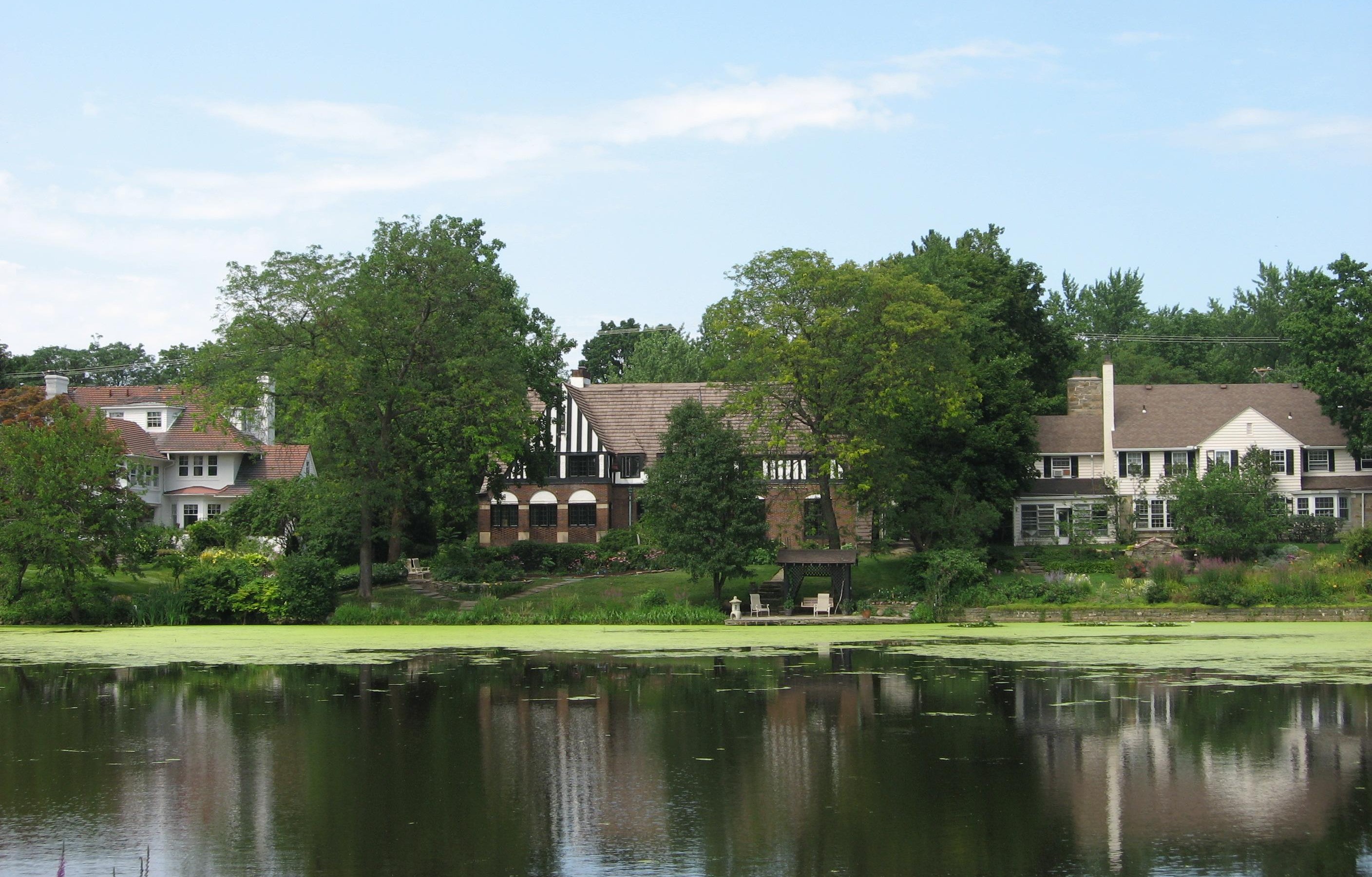
Shaker Heights is roughly 1,050 feet (320 m) above sea level,[1] and is located about six miles (10 km) inland from Lake Erie. Shaker Heights is drained by the Doan Brook watershed, and has several small artificial lakes: Horseshoe Lake, Green Lake, Lower Shaker Lake, and Marshall Lake.[4] Horseshoe Lake and Lower Shaker Lake had been dammed by the Shakers, while developers added Green Lake and Marshall Lake, the latter named after drugstore chain owner W. A. Marshall, at a later point.[5]
Climate
Shaker Heights has a humid continental climate (Koppen climate classification Dfa), which is similar to much of the midwest United States. This climate has very warm, humid summers and cold, snowy winters. The Lake Erie shoreline is very close to due east-west from the mouth of the Cuyahoga River west to Sandusky, but at the mouth of the Cuyahoga it turns sharply northeast. This feature is the principal contributor to the lake effect snow that is typical in Shaker Heights weather from mid-November until the surface of Lake Erie freezes, usually in late January or early February. Seasonal totals approaching or exceeding 100 inches (2,500 mm) are not uncommon because Shaker Heights is found in an area known as the "Snow Belt", extending from the east side of Cleveland proper through the eastern suburbs and up the Lake Erie shore as far as Buffalo, New York. Despite its reputation as a cold, snowy place in winter mild spells often break winter's grip with temperatures sometimes soaring above 68 °F (20 °C).[6]
The all-time record high in Shaker Heights of 104 °F (40 °C) was established on June 25, 1988, and the all-time record low of −20 °F (−29 °C) was set on January 19, 1994.[7] On average, July is the warmest month with a mean temperature of 71.9 °F (22.2 °C), and January, with a mean temperature of 25.7 °F (−3.5 °C), is the coldest. Normal yearly precipitation based on the 30-year average from 1971 to 2000 is 38.7 inches (930 mm).[8]
Climate data for Shaker Heights, Ohio Month Jan Feb Mar Apr May Jun Jul Aug Sep Oct Nov Dec Year Record high °F (°C) 73
(23)74
(23)83
(28)88
(31)92
(33)104
(40)103
(39)102
(39)101
(38)90
(32)82
(28)77
(25)104
(40)Average high °F (°C) 33
(1)36
(2)46
(8)57
(14)69
(21)77
(25)81
(27)79
(26)72
(22)61
(16)49
(9)37
(3)58.1
(14.5)Daily mean °F (°C) 26
(−3)29
(−2)38
(3)48
(9)59
(15)68
(20)72
(22)70
(21)63
(17)52
(11)42
(6)31
(−1)49.8
(9.9)Average low °F (°C) 19
(−7)21
(−6)29
(−2)38
(3)48
(9)58
(14)62
(17)61
(16)54
(12)44
(7)35
(2)25
(−4)41.2
(5.1)Record low °F (°C) −20
(−29)−16
(−27)−5
(−21)10
(−12)25
(−4)31
(−1)41
(5)38
(3)32
(0)19
(−7)3
(−16)−15
(−26)−20
(−29)Precipitation inches (mm) 2.48
(63)2.29
(58.2)2.94
(74.7)3.37
(85.6)3.50
(88.9)3.89
(98.8)3.52
(89.4)3.69
(93.7)3.77
(95.8)2.74
(69.6)3.38
(85.9)3.14
(79.8)38.71
(983.2)Source: [7] Cityscape

 A map of the neighborhoods in Shaker Heights
Shaker Heights is one of Greater Cleveland's older inner-ring or "first" suburbs, and borders Cleveland, Cleveland Heights, University Heights, Beachwood, Highland Hills, and Warrensville Heights.[9] Shaker Heights is a member of the Northeast Ohio First Suburbs Consortium.[10]
Neighborhoods
There are nine neighborhoods in Shaker Heights, all of which were named after the nine original elementary schools.[11] These neighborhoods are:
- Boulevard, located in northwest Shaker Heights, is near Cleveland's University Circle neighborhood, and borders Shaker Square. The Nature Center at Shaker Lakes is located in this neighborhood.
- Fernway is located in the middle of Shaker Heights, north of the RTA Rapid Transit Blue Line, and south of Shaker Heights Country Club.
- Lomond is located in the south-central part of the city.
- Ludlow is the smallest neighborhood and is located in the western portion of the city. Half of the neighborhood lies in Shaker Heights, while the other half is in Cleveland.[12]
- Malvern is mostly residential and is the location of Hathaway Brown School. The Hanna Perkins Center, a child development center, occupies the former Malvern school building.[13]
- Mercer, located in northeast Shaker Heights, is the largest neighborhood. The area is also home to Shaker Heights Middle School (previously Byron Junior High School), and the private schools University School and Laurel School. The eastern terminus of the RTA Rapid Transit Green Line, the Green Road Station, is located here, as well as the Bertram Woods branch of the Shaker Heights Public Library.
- Moreland is located in southwest Shaker Heights. The former Moreland school building now houses the Shaker Heights Public Library Main Branch.
- Onaway is home to Shaker Heights High School, and the former Woodbury Junior High School Building.
- Sussex is located in southeast part of the city and is the location of the Tower East office building.
Shaker Square is in the city of Cleveland, though, in an arrangement dating to the late 1920s, is in the Shaker Heights City School District.
Demographics
Historical populations Year Pop. ±% 1911 200 — 1920 1,600 +700.0% 1930 17,783 +1011.4% 1940 23,393 +31.5% 1950 28,222 +20.6% 1960 36,460 +29.2% 1970 36,606 +0.4% 1980 32,487 −11.3% 1990 30,831 −5.1% 2000 29,405 −4.6% 2010 28,448 −3.3% Source: [14][15] As of the census of 2000,[2] there were 29,405 people, 12,220 households, and 8,040 families residing in the city. The population density was 4,685.0 people per square mile (1,807.9/km²). There were 12,982 housing units at an average density of 2,068.4 per square mile (798.1/km²). The racial makeup of the city was 59.94% White, 34.11% African American, 0.06% Native American, 3.16% Asian, 0.01% Pacific Islander, 0.50% from other races, and 2.22% from two or more races. Hispanic or Latino of any race were 1.15% of the population. By 2010, the estimated percentage of Asians in Shaker Heights was 4.7%, the seventh-highest percentage for cities in Ohio, and the third-largest percentage for cities in Cuyahoga County.[16] About 93.5% of residents speak English natively at home, while 1.6% speak Spanish, 1.2% speak French, 0.7% speak Chinese, and 3.0% speak another language, including German, Russian and Arabic.[17]
There were 12,220 households out of which 32.1% had children under the age of 18 living with them, 50.1% were married couples living together, 12.9% had a female householder with no husband present, and 34.2% were non-families. 30.2% of all households were made up of individuals and 11.6% had someone living alone who was 65 years of age or older. The average household size was 2.39 and the average family size was 3.00.
In the city the population was spread out with 26.2% under the age of 18, 5.3% from 18 to 24, 27.4% from 25 to 44, 25.5% from 45 to 64, and 15.6% who were 65 years of age or older. The median age was 40 years. For every 100 females there were 83.6 males. For every 100 females age 18 and over, there were 78.5 males.
The median income for a household in the city was $63,983, and the median income for a family was $85,893. Males had a median income of $61,768 versus $38,606 for females. The per capita income for the city was $41,354. About 5.3% of families and 6.9% of the population were below the poverty line, including 8.1% of those under age 18 and 6.5% of those age 65 or over. According to a 2007 estimate,[18] the median income for a household in the city had risen to $68,793, and the median income for a family had risen to $93,380. About 6.1% of families and 8.6% of the population were below the poverty line.
History
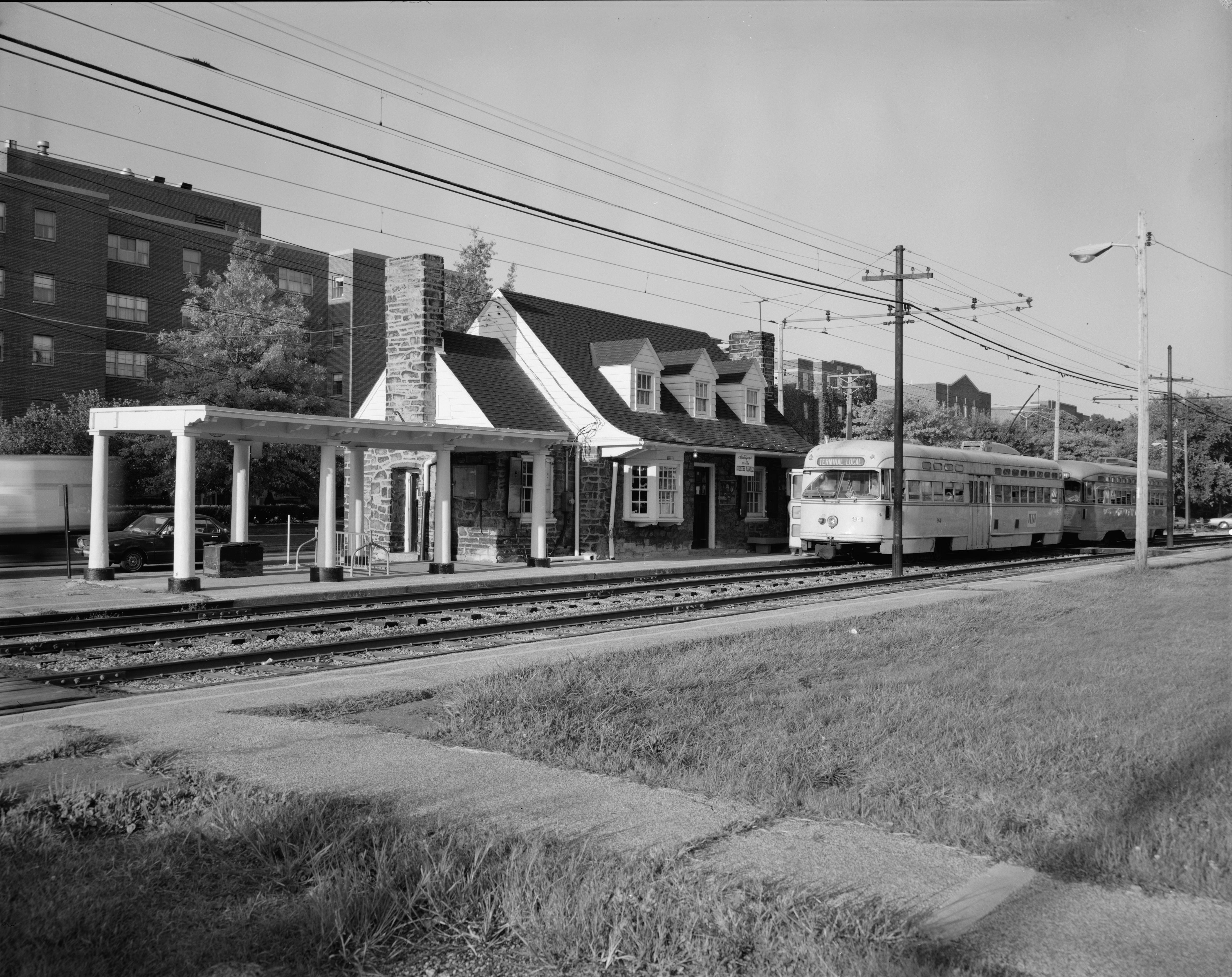
 A Blue Line streetcar at the Lynnfield station. This style of car, the PCC streetcar, was replaced in 1981 with the Breda LRV car.[19]
Shaker Heights was incorporated as a village in 1912. The name "Shaker Heights" has origins in two local sources. The community was laid out on land formerly owned by the North Union Community of the United Society of Believers, more commonly known as Shakers. "Heights" refers to the plateau east of Cleveland that rises sharply in elevation from 582 feet above sea level at the base of the Cedar Glen Parkway rising to 950 feet above sea level in nearby Cleveland Heights; Shaker Heights' elevation is 1050 feet above sea level.
Ralph Russell established the North Union Settlement in 1822 with just over 80 individuals. In 1826, the group dammed Doan Brook, thus creating the Lower Lake and establishing a gristmill and a sawmill. Later, in 1854, the community built a second dam creating the Upper Lake, and constructed another mill.[20] Also called 'The Valley of God's Pleasure', the colony peaked around 1850 with about 300 settlers.[21] As the Shakers practiced celibacy, the colony faded away and was closed in 1889. In 1905, the land was bought by brothers M.J. and O.P. Van Sweringen who envisioned the first garden styled suburb in Ohio for the site.[21] The brothers constructed homes, set aside land for churches and schools, and planted trees. Originally referred to as Shaker Village, the community was incorporated in 1912 and reached city status in the 1931.[22] Shaker Heights is known for its stringent building codes and zoning laws, which have helped to maintain the community's housing stock and identity throughout the years.[23] Approximately seventy percent of the city of Shaker Heights is listed on the National Register of Historic Places as Shaker Village Historic District.[24]
The Van Sweringens acquired the New York, Chicago and St. Louis Railroad (Nickel Plate Road) in order to secure the right of way needed to establish a rapid transit interurban streetcar system that would carry residents of Shaker Heights to and from downtown Cleveland. The resulting system was known as the Shaker Heights Rapid Transit. The Rapid Transit system was transferred into the Greater Cleveland Regional Transit Authority (RTA) in the 1970s, which combined the operation of all bus systems in the county with the operation of the Shaker and Cleveland Transit System west side rapid lines.[19] Shaker Heights and Greater Cleveland refer to the system and to the trains as "The Rapid Transit", "Rapid" or "Shaker Rapid". While originally envisioned to extend from downtown Cleveland fourteen miles to the community of Hunting Valley (then called Shaker Estates), the system expansion ended at Green Road in eastern Shaker Heights following the collapse of the Van Sweringen rail empire during the Great Depression.
Efforts toward integration began in the late 1950s with neighbors in the Ludlow Elementary School area working together to make integration successful.[12] As a result, Shaker Heights avoided many of the problems created from practices such as blockbusting and white flight. In 1986, the city began a Fund for the Future of Shaker Heights, offering loans for down payments for residents buying homes in segregated neighborhoods, creating multi-ethnic neighborhoods.[25] Today, the city maintains a housing assistance office that works with home buyers to achieve and maintain neighborhood integration. In August 2004, the story of early integration efforts in Shaker Heights was subject of The Reunion,[26] an ABC News special produced by Paul Mason. Mason, now a senior vice president of ABC News, was a student at Ludlow Elementary School when residents, including his parents, moved forward with their efforts to make neighborhood integration a community project.
Shaker Heights was a finalist for the All-America City Award in 1989.[27]
Government and politics
 The Shaker Heights City Hall
The Shaker Heights City Charter was adopted in 1931 and revised in 1974, 1986 and 1999. This charter provides for a mayor and seven members of a city council, elected on an at-large, non-partisan basis for four years. The current mayor of Shaker Heights is Earl Leiken.[28] The last mayoral and council elections being in 2007, the mayor and four council members selected in one election and three council members at the following, in a way to stagger terms.[29]
The Neo-Georgian city hall, designed by Charles Schneider, was built in 1930.[30]
Shaker Heights is entirely within the Eleventh Congressional District, a seat in the House of Representatives currently held by Marcia Fudge.[31]
Education
Publicly, Shaker Heights is served by the Shaker Heights City School District, a K-12 district with an enrollment of about 5,600 with eight total schools. There are five lower elementary schools, Fernway, Mercer, Boulevard, Lomond and Onaway; an upper elementary school, Woodbury Elementary School; Shaker Heights Middle School; and Shaker Heights High School. The district estimates that roughly 90% of Shaker graduates attend college,[32] and has been recognized for its efforts to increase neighborhood integration.[33] In the 1950s, the public school system was rated in the top ten nationally. In recent years, however, the school district is no longer top rated. According to the 2007-2008 State of Ohio Report Card, Shaker scored 97.1 out of a possible 120. The district is listed as "Effective," the third tier on a 6 tier scale.[34] On the other hand, since 1995, 9-17% of seniors at Shaker Heights High School have been recipients of National Merit Scholarship awards,[35] and in 2008, the high school had twice as many National Merit Scholarship winners as any other public school in the state.[36] This can possibly be explained in a 2009 survey of the school, which said that Shaker Heights High School "is really two schools – one school with students in an outstanding Advanced Placement program and one school with students with academic needs."[37]
Private schools in the city include Laurel School, Hathaway Brown School, and the lower campus of University School. There is also a parochial school in Shaker, St. Dominic School.[38]
John Carroll University is partially located in Shaker Heights, with the university owning several residential and commercial properties in the city.[39] Additionally, Shaker Heights is in close proximity to University Circle, which is home to Case Western Reserve University, The Cleveland Institute of Art, and the Cleveland Institute of Music.
Media
 The main branch of the Shaker Heights Public Library, a member of the CLEVNET consortium.[40]
Shaker Heights is the city of license for CBS affiliate WOIO, channel 19, which has its studios and offices in Cleveland.[41] Shaker Heights news appears in the Cleveland daily newspaper, The Plain Dealer. The Sun Press, a weekly, provides local coverage of Shaker Heights and neighboring Beachwood, Cleveland Heights, and University Heights.[42]
See also
- List of people from Shaker Heights, Ohio
- Nature Center at Shaker Lakes
- The Battle of Shaker Heights (film set in Shaker Heights)
References
- ^ a b c "US Board on Geographic Names". United States Geological Survey. 2007-10-25. http://geonames.usgs.gov. Retrieved 2008-01-31.
- ^ a b "American FactFinder". United States Census Bureau. http://factfinder.census.gov. Retrieved 2008-01-31.
- ^ "US Gazetteer files: 2010, 2000, and 1990". United States Census Bureau. 2011-02-12. http://www.census.gov/geo/www/gazetteer/gazette.html. Retrieved 2011-04-23.
- ^ Behnke Associates, Inc.. "The Doan Brook Watershed" (PDF). The Holden Parks Trust Distribution Committee. pp. 1. http://shakeronline.com/Media/PDFs/Uploader/4102004121052DoanMap.pdf. Retrieved 2008-01-20.
- ^ Marshall, Bruce T. (2006). Shaker Heights. Arcadia Publishing. pp. 69. ISBN 0738540501. http://books.google.com/books?id=vFreGYJZb4sC&dq=shaker+heights&source=gbs_navlinks_s. Retrieved 04 June 2011.
- ^ "Observed Weather Reports". 2008-01-07. http://www.weather.gov/climate/getclimate.php?wfo=cle. Retrieved 2008-03-14.
- ^ a b "Monthly Averages for Cleveland, OH (44120)". The Weather Channel. http://www.weather.com/weather/wxclimatology/monthly/graph/44120?from=month_bottomnav_undeclared. Retrieved 2008-01-21.
- ^ NOWData - NOAA Online Weather Data. National Weather Service. Retrieved on 2006-04-05.
- ^ Housing Policy Research Program, Cleveland State University College of Urban Affairs. "Cities of the First Suburbs Consortium". http://www.ecocitycleveland.org/smartgrowth/sgagenda/first_suburbs/firstsuburbs_map.html. Retrieved 2008-03-19.
- ^ "Northeast Region". Northeast Ohio First Suburbs Consortium. http://www.firstsuburbs.org/neohio/index.htm. Retrieved 2007-05-09.
- ^ "Shaker Neighborhoods". Shaker Online. 2008. http://www.shakeronline.com/relocation/buying/ShakerNeighborhoods.asp. Retrieved 2008-02-05.
- ^ a b Maag, Christopher (2008-01-17). "A Suburb Looks Nervously at Its Urban Neighbor". New York Times. http://www.nytimes.com/2008/01/17/us/17shaker.html?em&ex=1201323600&en=d36350670ee5d352&ei=5070. Retrieved 2008-06-12.
- ^ "Directions to the Hanna Perkins Center for Child Development". 2007. Archived from the original on 2007-12-31. http://web.archive.org/web/20071231074137/http://www.hannaperkins.org/directions_to_HPC.htm. Retrieved 2008-02-05.
- ^ "75 Years An Informal History of Shaker Heights" (PDF). Shaker Heights Public Library. p. 26. http://www.shpl.lib.oh.us/doc/75years2.pdf. Retrieved 2008-02-27.
- ^ "Shaker Heights city, Cuyahoga County, Ohio: General Population and Housing Characteristics: 1990". US Census Bureau. 1990. http://factfinder.census.gov/servlet/QTTable?_bm=y&-geo_id=06000US39035247&-qr_name=DEC_1990_STF1_DP1&-ds_name=D&-_lang=en. Retrieved 2008-02-27.
- ^ Exner, Rich (2010-02-13). "Estimates show Westlake is home to the greatest concentration of Asians in Greater Cleveland". Cleveland Plain Dealer. http://www.cleveland.com/datacentral/index.ssf/2010/02/estimates_show_westlake_is_hom.html. Retrieved 2 March 2010.
- ^ "MLA's Data Center Results for Shaker Heights, Ohio". Modern Language Association. 2000. http://www.mla.org/cgi-shl/docstudio/docs.pl?map_data_results. Retrieved 21 June 2010.
- ^ "Shaker Heights city, Ohio". US Census Bureau. 2007. http://factfinder.census.gov/servlet/ACSSAFFFacts?_event=Search&geo_id=16000US3983342&_geoContext=01000US%7C04000US39%7C16000US3983342&_street=&_county=shaker+heights&_cityTown=shaker+heights&_state=04000US39&_zip=&_lang=en&_sse=on&ActiveGeoDiv=geoSelect&_useEV=&pctxt=fph&pgsl=160&_submenuId=factsheet_1&ds_name=ACS_2007_3YR_SAFF&_ci_nbr=null&qr_name=null®=null%3Anull&_keyword=&_industry=. Retrieved 2009-02-13.
- ^ a b "About RTA: History of Public Transit in Greater Cleveland". Greater Cleveland Regional Transit Authority. 2007. http://www.gcrta.org/ar_RTAhistory.asp. Retrieved 2008-04-08.
- ^ "North Union Shaker Site". National Park Service. http://www.nps.gov/history/nr/travel/shaker/nor.htm. Retrieved 2008-03-21.
- ^ a b "The North Union Shakers". http://www.shakerworkshops.com/shaker-villages-and-museums/shaker-historical-society-and-museum.htm. Retrieved 2008-01-20.
- ^ "Shaker Heights". Encyclopedia of Cleveland History. CWRU. 2003. http://ech.cwru.edu/ech-cgi/article.pl?id=SH3. Retrieved 4 June 2011.
- ^ Segall, Grant (2008-12-02). "Demolition crew uncovers long-hidden Philco sign in Shaker Heights". The Plain Dealer. http://www.cleveland.com/cuyahoga/plaindealer/index.ssf?/base/cuyahoga/1228210343218530.xml&coll=2. Retrieved 2008-12-13.
- ^ Mitchell, Sandy. "Shaker Heights, Ohio". http://cleveland.about.com/od/neighborhoods/p/shakerheights.htm. Retrieved 2008-01-20.
- ^ Keating, W. Dennis (September 1988). "Suburban Cleveland's 20-Year Integration Struggle". American Planning Association. http://www.planning.org/25anniversary/planning/1988sep.htm. Retrieved 2008-06-12.[dead link]
- ^ Norris, Michele. 'The Reunion:' The Integration of Shaker Heights, All Things Considered, 2004-08-18.
- ^ "Past Winners of the All-America City Award". Archived from the original on 2007-08-14. http://web.archive.org/web/20070814061126/http://www.ncl.org/aac/past_winners/past_winners_1980s.html. Retrieved 2007-10-08.
- ^ Catanese, Marie (2008-11-07). "Leiken is new Shaker mayor; three return to council". Sun Press. http://blog.cleveland.com/sunpress/2007/11/leiken_is_new_shaker_mayor_thr.html. Retrieved 2008-12-13.
- ^ "Inside City Hall: City Council". 2007. http://shakeronline.com/cityhall/council/. Retrieved 2008-01-20.
- ^ Forgac, Patricia (May 1981). "Architecture". The Physical Development of Shaker Heights. Ohio: Kent State University. pp. 106.
- ^ "Congressional District 11" (GIF). National Atlas of the United States. United States Department of the Interior. Archived from the original on 2008-04-08. http://web.archive.org/web/20080408225315/http://www.ams.usda.gov/statesummaries/OH/Districts/DistrictMaps/District+11+480.gif. Retrieved 2008-03-25.
- ^ "Fast Facts". Shaker Heights Schools. 2006. http://www.shaker.org/about/overview/facts.htm. Retrieved 2008-01-25.
- ^ Brand-Williams, Oralandar (2002-01-28). "Shaker Heights: City works at integration". The Detroit News. http://www.s4.brown.edu/cen2000/othersay/detroitnews/Stories/Shaker%20Heights%20City%20works%20at%20integration%20-%2001-28-02.pdf. Retrieved 2009-02-14.
- ^ Heights City, Cuyahoga County "Shaker Heights City School District Report Card". State of Ohio Department of Education. 2008. http://ilrc.ode.state.oh.us/Districts/District_Questions.asp?sel=044750,Shaker Heights City, Cuyahoga County. Retrieved 2008-11-25.
- ^ "National Merit, National Achievement, and National Hispanic Scholarship Programs". Shaker Heights City School District. 2008-10-13. http://www.shaker.org/news/releases/2007-08/historicalchart.htm. Retrieved 2008-12-13.
- ^ Stephens, Scott (2008-05-12). "Shaker students score National Merit Scholarships". The Plain Dealer. http://blog.cleveland.com/metro/2008/05/shaker_students_score_national_1.html. Retrieved 2008-12-13.
- ^ "Report of the Quality Assurance Review Team for Shaker Heights High School". AdvancED Worldwide. 2009. pp. 9. http://www.shaker.org/about/schools/high/documents/qarPDF.pdf. Retrieved 23 April 2010.
- ^ "About Shaker: Education". Shaker Online. http://www.shakeronline.com/about/education/. Retrieved 2008-01-21.
- ^ Jewell, Thomas (2010-02-25). "John Carroll University and Shaker Heights reach off-campus housing accord". Sun News. http://blog.cleveland.com/sunpress/2010/02/john_carroll_university_and_sh.html. Retrieved 16 July 2010.
- ^ "CLEVNET Consortium". Cleveland Public Library. 2008. http://www.cpl.org/index.php?q=node/90. Retrieved 2008-06-09.
- ^ "FCC Information:WOIO". Federal Communications Commission. http://www.fcc.gov/fcc-bin/tvq?call=WOIO. Retrieved 2008-01-20.
- ^ "History of the Sun Newspapers". Case Western Reserve University. 1997-06-30. http://ech.case.edu/ech-cgi/article.pl?id=SN. Retrieved 2008-01-20.
Further reading
- Marshall, Bruce T. (2006). Shaker Heights. Arcadia Publishing. ISBN 0738540501.
- Campen, Richard (1992). Distinguished Homes of Shaker Heights. Kent State University Press. ISBN 0960135677.
External links

Cleveland, Ohio Cleveland Heights, Ohio University Heights, Ohio Cleveland, Ohio 
Beachwood, Ohio  Shaker Heights

Cleveland, Ohio and Warrensville Heights, Ohio Highland Hills, Ohio Categories:- Cities in Ohio
- Populated places in Cuyahoga County, Ohio
- Planned communities
- Shakers
- Shaker Heights, Ohio
- Streetcar suburbs
- Populated places established in 1911


Wikimedia Foundation. 2010.