- Comhairle nan Eilean Siar
-
Na h-Eileanan Siar 
Logo Coat of arms Location 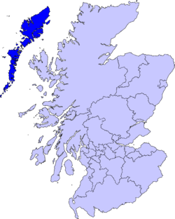
Geography Area Ranked 7th - Total 3,071 km2 (1,186 sq mi) Admin HQ Stornoway
(Steòrnabhagh)ISO 3166-2 GB-ELS ONS code 00RJ Demographics Population Ranked 30th - Total (2005) 26,200 - Density 9 / km² Politics Comhairle nan Eilean Siar
http://www.cne-siar.gov.uk/Control Independent MPs MSPs Comhairle nan Eilean Siar is the local government council for Na h-Eileanan Siar council area of Scotland.
It is the only local council in Scotland to have a Gaelic-only name. Western Isles Council was retracted in 1997 under the Local Government (Gaelic Names) (Scotland) Act 1997, meaning that the former Western Isles are now officially named Na h-Eileanan Siar, even in English-language contexts.
The council was created in 1975, 57 years after the creation of Na h-Eileanan an Iar for elections to the House of Commons of the Parliament of the United Kingdom (the constituency being named, when created, Western Isles). Since 1999, there has been also the Na h-Eileanan an Iar constituency of the Scottish Parliament, with the same boundaries.
Elections
Pronunciation Scots Gaelic: Comhairle nan Eilean Siar Pronunciation: [ˈkʰõ.ərˠʎə nə ˈɲelan ˈʃiəɾ] (  listen)
Scots Gaelic: Na h-Eileanan an Iar Pronunciation: [nə ˈhelanən ə ˈɲiəɾ] ( listen)Scots Gaelic: Na h-Eileanan Siar Pronunciation: [nə ˈhelanən ˈʃiəɾ] ( listen)General elections to the council are held on a four year cycle. The next is due in 2012.
During the period since 1975, elections to the council have been by the first past the post system of election with the final elections of this type returning 31 councillors, elected by 31 single-member wards.
In 2007, under the Local Governance (Scotland) Act 2004, the single transferable vote system, together with multi-member wards, was used for the first time, each ward electing three or four councillors. This system is designed to produce a form of proportional representation.
Governance
The council is governed by Independents, who hold 25 of the 31 seats, and organized political parties have a very small presence on the council, with four Scottish National Party members and two from the Labour Party.
The political composition for Na h-Eileanan Siar council after the 2007 local elections is as follows.
Comhairle nan Eilean Siar Local Election Result 2007 Party Seats Gains Losses Net gain/loss Seats % Votes % Votes +/- Independent 25 N/A N/A 80.6 78.8 10,853 SNP 4 N/A N/A 12.9 12.1 1,661 Labour 2 N/A N/A 6.5 6.7 916 Liberal Democrats 0 N/A N/A 0.0 2.5 340 External links
Categories:- Highlands and Islands of Scotland
- Local authorities of Scotland
- Politics of the Outer Hebrides
- Scottish organisation stubs
- Scotland politics stubs
- United Kingdom government stubs

Wikimedia Foundation. 2010.