- Cheadle, Greater Manchester
-
Not to be confused with Cheadle Heath or Cheadle Hulme.
Coordinates: 53°23′36″N 2°12′41″W / 53.3933°N 2.2113°W
Cheadle 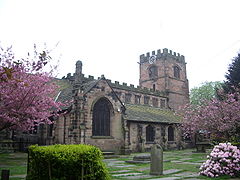
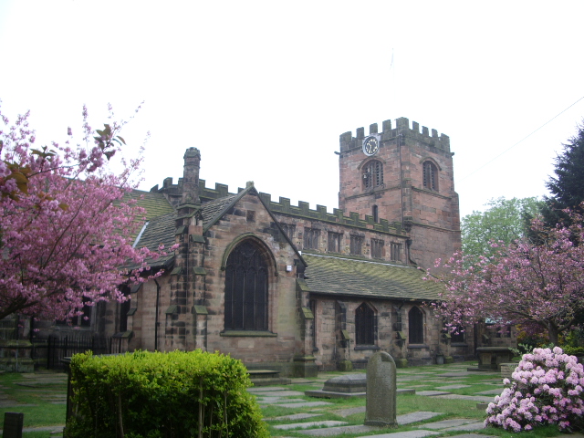
St Mary's Church, built in the 16th century, is situated in the centre of Cheadle.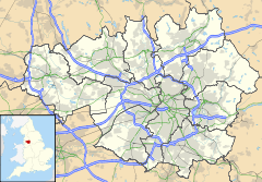
 Cheadle
Cheadle shown within Greater ManchesterPopulation 14,261 OS grid reference SJ859885 Metropolitan borough Stockport Metropolitan county Greater Manchester Region North West Country England Sovereign state United Kingdom Post town CHEADLE Postcode district SK8 Dialling code 0161 Police Greater Manchester Fire Greater Manchester Ambulance North West EU Parliament North West England UK Parliament Cheadle List of places: UK • England • Greater Manchester Cheadle is a suburb in the Metropolitan Borough of Stockport in Greater Manchester, England. It borders the districts of Cheadle Hulme, Gatley, Heald Green and Cheadle Heath in Stockport, and the East Didsbury area of Manchester. As of 2001 it had a population of 14,261.
Contents
History
Early history
There has been human occupation in Cheadle since prehistoric times. The earliest evidence of civilisation is of burial mounds dating from the iron age, belonging to Celts who occupied Britain. Later, the area was occupied by Brigantes, whose activity was discovered in the form of axe fragments.
In the first millennium, Romans occupied the area, and their coins have been discovered. During the seventh century St. Chad preached in the area,[1] and a stone cross dedicated to him was found close to the confluence of the River Mersey and Micker Brook in 1873.[2] This area became known as Chedle, a corruption of Chad' Hill.
The village is first recorded in the Domesday Book under the name "Cedde",[3] which comes from the Celtic word for "wood".[4] It was held by Gamel, a free Saxon under Hugh d'Avranches, 1st Earl of Chester; it was about three miles long and half as wide, containing both wooded and open land, with areas enclosed for hunting purposes.[3] This early manor occupied the approximate areas of both modern day Cheadle and Cheadle Hulme.
By June 1294, Geoffrey de Chedle was lord of the manor, and it was valued at about £20 per annum. Geoffrey's descendant Robert (or Roger) died in the early 1320s, leaving the estate to his wife Matilda who held it until her death in 1326.[2] As there were no male heirs the manor, which was now worth £30 per annum,[5] was divided between her daughters, Clemence and Agnes. Agnes inherited the northern half (which would later become the modern-day Cheadle), and Clemence inherited the southern half (latterly Cheadle Hulme). The two areas became known as "Chedle Bulkeley" and "Chedle Holme" respectively.
William de Bulkeley succeeded his mother, and was a participant in several wars in France for Edward, the Black Prince. His son, Richard, was sent to live at the court Richard II, and later to a baron whose daughter Margery married Richard. Richard died at the age of 21, but Margery lived until she was about 90 year old. She was succeeded by her grandson and great-grandson, both named William. Shortly after the Battle of Bosworth, the latter William was succeeded by his brother Richard.[6]
During the reign of Henry VIII, the current St Mary's Church on High Street was built.[7] There has been a church on the site since the 12th century, the original being constructed of wood,[3] but it was rebuilt in stone between 1520 and 1550.[8] The church contains an effigy of John Stanley who, along with many other men from the area, fought in the Battle of Flodden Field.[7] Later he claimed the manor for himself, but was imprisoned by Thomas Wolsey who ensured the land went to its rightful owner.[9]
The Bulkeleys continued to hold the lands as lords of the manor until the 18th century, when the manor was purchased by Thomas Egerton.
During the Bonnie Prince Charlie uprising, the Young Pretender's troops marched through Cheadle. Some remains have been found, including swords.[citation needed]
Moseley Old Hall, an early Stuart mansion dating from 1666 is still standing and is owned privately. It is situated at the end of a blocked-off public road, making hard to find and therefore quite unheard of.
Abney Hall is a late Victorian hall from 1847 and is the old Cheadle town hall, though is now used for offices. It is surrounded by parkland which is open to the public all year round and features some of the only wetlands left in Stockport.
Modern history
Cheadle grew rapidly during the Industrial Revolution when it was used as a stopping point for travellers and merchants on their way to Central Manchester.
Governance
Lying within the historic county boundaries of Cheshire, Cheadle was historically an ecclesiastical parish known as "Cheadle Bulkeley" in the Hundred of Stockport. Following the Municipal Corporations Act 1835, part of Cheadle Bulkeley was amalgamated into the Municipal Borough of Stockport. In 1879, the remaining part was merged with neighbouring Cheadle Moseley to form the township of Cheadle.[10]
Established in 1886, Cheadle's first local authority was the Cheadle and Gatley local board of health, a regulatory body responsible for standards of hygiene and sanitation for the area of Stockport Etchells township and the part of Cheadle township outside the Municipal Borough of Stockport. The board of health was also part of Stockport poor law union. In 1888 the board was divided into four wards: Adswood, Cheadle, Cheadle Hulme and Gatley.[11] Under the Local Government Act 1894 the area of the local board became Cheadle and Gatley Urban District. There were exchanges of land with the neighbouring former urban districts of Wilmslow and Handforth in 1901, and the wards were restructured again, splitting Cheadle Hulme into north and south, and merging in Adswood.[11] Due to the fast-paced growth of the district, the wards were again restructured in 1930, with the addition of Heald Green. In 1940 the current wards of Adswood, Cheadle East, Cheadle West, Cheadle Hulme North, Cheadle Hulme South, Gatley and Heald Green were established.[12] Under the Local Government Act 1972 the Cheadle and Gately Urban District was abolished, and Cheadle has, since 1 April 1974, formed an unparished area of the Metropolitan Borough of Stockport within the metropolitan county of Greater Manchester.[10]
Since 1950 Cheadle has been part of the Cheadle parliamentary constituency,[13] and has been represented by Liberal Democrat member Mark Hunter since 2005.[14] Three councillors serve on the borough council.[15]
Education
The following educational establishments are in Cheadle:
- Primary schools
- Cheadle Primary School
- Ladybridge Primary School
- Meadowbank Primary School
- Secondary schools
- Special schools
- Together Trust (made up of Child and Youth Care Education Service (CYCES) and Inscape House)
- Independent schools
Cheadle Blitz
Cheadle suffered at the hands of the German Luftwaffe with civilian casualties, with the first raid taking place on the night of 24 December, 1940. The planes are believed to have been twin-engined Heinkel bombers, which came under local fire from mobile anti-aircraft battery at the junction of Kingsway and Broadway. A 1000 pound landmine was released on a target thought to be a factory manufacturing aircraft wings, however the bomb missed the factory altogether, landing directly on a house in Bulkeley Road, Cheadle. The second air raid took place on the night of 4 February, 1941 where a lone bomber made a direct hit on a house in Stockport Road. Both occupants, mother and daughter, were killed outright as was a local fire watcher, Robert Campbell. The last victim, also a fire watcher, received wounds which took his life the next day. Those who lost their lives:
- Ronald Frederick Harrison
- Miss Nora Jackson
- John Thomas Lydiatt
- Agnes Mary Roughton Bennison
- Kathleen Mary Bennison
- Robert Campbell
The above named are buried in Cheadle & Gatley Cemetery. Maria Brookes is buried in Hayhead, whilst Fred Miller is buried in Denton.
All eight casualties are named on the war memorial located in Cheadle Village. Unusually, "Cheadle is one of the few villages which named its air raid victims on the War Memorial located in Cheadle Village."[16]
Transport
Cheadle's public transport is now confined to buses operated by several firms. However from 1866 until 1964 the locality was served by a Cheshire Lines Committee railway station (initially called Cheadle, from 1950 Cheadle North) situated 600 yards (550 m) north of the village on the west side of Manchester Road and from 1866 until 1917 by a London & North Western Railway station located next to the railway overbridge near the centre of the village. Both stations were on lines leading from Altrincham to Stockport.
East Didsbury within the City of Manchester's boundaries is currently the nearest station to Cheadle.
Neighbouring districts and places. 
Didsbury Heaton Mersey Stockport Northenden
Gatley
Cheadle Heath  Cheadle

Heald Green Cheadle Hulme Bramhall Present day
Cheadle has continued to thrive primarily due to its location near the southern tip of Greater Manchester. The neighbouring district of Cheadle Hulme borders onto Cheshire. Cheadle is accessed by the M60 Manchester orbital motorway. It is situated approximately 8 miles from Manchester City Centre, approximately 3 miles from Stockport Town Centre, and approximately 4 miles from Manchester Airport.
A number of houses in Cheadle that were built in the 1800s still stand today. The houses in the conservation area in the centre of the village, near the railway bridge by the Ashlea pub, and both Frances Street and Brook Street have an abundance of old world character and charm rarely seen in South Manchester urban sprawl.
There is also a Manchester overspill council estate that was constructed shortly after the Second World War. Since April 2008, these homes were transferred to Mossbank Homes.
Cheadle is home to the HQ of sportswear giants Umbro.
See also
- Cheadle - The Cheadle constituency.
- Cheadle Town Football Club
- Cheadle, Alberta, Canada - A Canadian town, also called Cheadle
Notes
- ^ Clarke, p.1
- ^ a b Squire, p.1
- ^ a b c Clarke, p.3
- ^ Mills, A. D. (2003). A Dictionary of British Place-Names.. Oxford University Press.
- ^ Squire, p.2
- ^ Clarke, p.4
- ^ a b Clarke, p.5
- ^ "Basic History". St Mary's Church, Cheadle. http://www.cheadle.org/histintro.htm. Retrieved 3 September 2009.
- ^ Clarke, p.6
- ^ a b "Greater Manchester Gazetteer". Greater Manchester County Record Office. Places names - C. http://www.gmcro.co.uk/Guides/Gazeteer/gazzc.htm. Retrieved 3 September 2009.
- ^ a b Bowden, p.25
- ^ Bowden, p.27
- ^ Craig, p.53
- ^ "Lib Dems win Cheadle by-election". BBC News Online (BBC). 15 July 2005. http://news.bbc.co.uk/1/hi/uk_politics/4681533.stm. Retrieved 18 March 2009.
- ^ "Councillors". Stockport Metropolitan Borough Council. 2 May 2008. http://www.stockport.gov.uk/services/councildemocracy/democracy/councillors. Retrieved 5 April 2010.
- ^ "Two Fatal Air Raids in Cheadle", by John H Simmonds, 1992.
References
- Bowden, Tom (3 January 1974). Community and Change: A History of Local Government in Cheadle and Gatley. Cheadle and Gatley Urban District Council.
- Clarke, Heather (1972). Cheadle Through The Ages. E.J. Morten. ISBN 0-901598-44-5.
- Craig, Fred W. S. (1972). Boundaries of parliamentary constituencies 1885–1972. Political Reference Publications. ISBN 0-900178-09-4.
- Squire, Carol (January 1976). Cheadle Hulme: A Brief History. Recreation and Culture Division, Metropolitan Borough of Stockport.
External links
- Cheadle Online - Cheadle Community Website
- Moseley Hall Grammar School - Moseley Hall Grammar School Web Site
Categories:- Towns in Greater Manchester
- Geography of Stockport

Wikimedia Foundation. 2010.