- Australian Capital Territory
Australia state or territory
Name = Australian Capital Territory
Fullname = Australian Capital Territory
the = the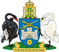
Motto = For the Queen, the Law and the People
Nickname = "The Nations Heart" or "The Capital"
Emblems = The floral emblem of the ACT is the Royal Bluebell and the faunal emblem is the Gang-gang cockatoo
Emblem_title1 = Floral
Emblem1 =Royal Bluebell
Emblem_title2 = Faunal
Emblem2 =Gang-gang cockatoo
Emblem_title3 = Colours
Emblem3 = Blue and Gold [http://www.cmd.act.gov.au/communication/flags}]
Emblem_title4 =
Emblem4 =
Emblem_title5 =
Emblem5 =
Emblem_title6 =
Emblem6 =
Capital =Canberra
ChiefType = Chief Minister
Chief =Jon Stanhope
ChiefParty = ALP
Viceroy =Governor General of Australia
ViceroyType = Administrator
PostalAbbreviation = ACT
EntityAdjective = Territorial
GSP = $20,985 [ [http://www.abs.gov.au/AUSSTATS/abs@.nsf/mf/5220.0 Australian National Accounts: State Accounts, 2006-07] ]
GSPYear = 2006-07
GSPRank = 6th
GSPPerCapita = $62,793
GSPPerCapitaRank = 2nd
AreaRank = 8th
TotalArea = 2358
LandArea = 2280
WaterArea = 77.6
HighestPoint =Bimberi Peak
HighestElev = 1,912 m
HighestElev_ft = 6,273
LowestPoint =Murrumbidgee River
LowestElev = 429 m
LowestElev_ft = 1,407
PercentWater = 3.29
PopulationRank = 7th
Population = 339,900
PopulationYear = End of June 2007
DensityRank = 1st
Density = 144.15
TimeZone = UTC+10 (+11 DST)
HouseSeats = 2
SenateSeats = 2
ISOCode = AU-ACT
Website = www.act.gov.auThe Australian Capital Territory (ACT) is the
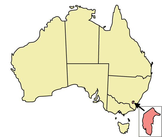
capital territory of the Commonwealth of Australia and its smallest self-governing internal territory. It is an inlandenclave inNew South Wales , situated in bushland.The ACT was conceived during the Federation conventions of the late 19th century as a neutral location for a new national capital. Section 125 of the Australian Constitution provided that following Federation in 1901, land would be ceded freely to the new Federal Government. The territory was transferred to the Commonwealth by the state of New South Wales in 1911, and construction of the capital,
Canberra , began in 1913.The floral emblem of the ACT is the Royal Bluebell and the faunal emblem is the
Gang-gang cockatoo .cite web
url = http://www.anbg.gov.au/emblems/act.emblem.html
title = Floral Emblem of the ACT
accessdate = 2007-05-27
author = Boden, Anne
date = 2007-05-23] Cite web
title = Australian Capital Territory
url = http://www.parliament.curriculum.edu.au/act.php3#symbol
accessdate = 2007-05-27]History
Before European settlement the area now known as the ACT was inhabited by three Aboriginal tribes: the Ngunnawal,
Walgalu , andNgarigo .White exploration and settlement did not occur until the 1820s. From 1824 onwards, settlements and homesteads, and ultimately some small townships such as Hall and Tharwa, were established in the area.
One homestead of special historical interest was Lambrigg, near Tharwa. This was the place in which
William Farrer developed the rust-resistant Federationwheat strain that had a major beneficial effect on Australia's wheat industry.When the constitution for the
Commonwealth of Australia was being negotiated between the colonies, a point of contention between the colonies was the location of the national capital, with bothMelbourne andSydney claiming the right to be the capital. A compromise was reached whereby a separate capital city would be created in New South Wales, provided it was no closer than convert|100|mi|km to Sydney. Until such time as the new city was established, Melbourne was to be the temporary capital of Australia.The present site was chosen in 1908, [ [http://www.foundingdocs.gov.au/item.asp?dID=110 National Archives of Australia - Seat of Government Act 1908 (Cth)] ] with additional territory at Jervis Bay (now a naval base on the New South Wales coast) allocated so the national capital could have a seaport. In 1909 New South Wales transferred the land for the territory to federal control and in 1910 an act of parliament created the legal framework for the Federal Capital Territory (FCT). [ [http://www.foundingdocs.gov.au/item.asp?sdID=93 National Archives of Australia - Seat of Government Acceptance Act 1909 (Cth)] ] [ [http://www.foundingdocs.gov.au/item.asp?dID=111 National Archives of Australia - Seat of Government (Administration) Act 1910 (Cth)] ] The Minister for Home Affairs,
King O'Malley , who had charge of thelegislation creating the FCT, also proposed a bill making it an alcohol-free area. With his strong support, the bill became law later that year, though it was shortly thereafter repealed. O'Malley also pushed for a form of land tenure that restricted land holders toleasehold , rather than freehold, on the basis that this would stop land speculation and give the national government, as the lessor, more control over development. This too was adopted by the national Parliament. (As of 2006 all land in the ACT is held on 99 year crown leases.)In 1911 Colonel David Miller, the Secretary of the Department of Home Affairs, had the idea for an international competition "to obtain the very best design of the most modern lines for this city". The winner was American architect
Walter Burley Griffin .cite web
url = http://naa.naa.gov.au/Publications/fact_sheets/FS95.html
title = National Archives of Australia - Walter Burley Griffin and the Design of Canberra
accessdate = 2007-05-27] Colonel Miller became Administrator of the FCT on 8 August 1912. [Michael Hall, "Early Administration in the Territory", from "Australia - 100 Years as a Nation", Canberra Times, 1 January 2001] Canberra was officially named on March 12, 1913, by Lady Denman, the wife of the governor-general Lord Denman; construction of the city began immediately.The seat of the Federal Government officially moved to the FCT from Melbourne on the formal opening of the Provisional Parliament House on 9 May 1927. Among the first acts passed by the parliament in its new location was the repealing of the
prohibition laws . At first the public service continued to be based inMelbourne , but the various departments were gradually moved toCanberra over many years.In 1938, the Federal Capital Territory was formally renamed the Australian Capital Territory (ACT).Cite web
url = http://www.parliament.curriculum.edu.au/act.php3#how
title = Parliaments At Work - How
accessdate = 2007-05-27]In a 1978
referendum , Canberrans rejected self-government by 63% of the vote. [ [http://www.parliament.curriculum.edu.au/act.php3 Parliament@Work - At a Glance Australian Capital Territory] ] Despite this, in December 1988, the ACT was granted full self-government through an Act of the Commonwealth Parliament that made the ACT a body politic under the crown. [ [http://www.foundingdocs.gov.au/item.asp?dID=118 National Archives of Australia - Australian Capital Territory (Self-Government) Act 1988 (Cth)] ] Following the first elections in February 1989, a 17-member Legislative Assembly sat at its offices in London Circuit, Civic, on May 11, 1989. TheAustralian Labor Party formed the ACT's first government, led by the Chief MinisterRosemary Follett , who made history as Australia's first female head of government.Geography
The ACT is bounded by the
Goulburn -Cooma railway line in the east, the watershed ofNaas Creek in the south, the watershed of theCotter River in the west, and the watershed of theMolonglo River in the north-east.Apart from the city of Canberra, the Australian Capital Territory also contains agricultural land (sheep,
dairy cattle ,vineyard s and small amounts of crops) and a large area of national park (Namadgi National Park ), much of it mountainous and forested. Small townships and communities located within the ACT include Williamsdale, Naas, Uriarra, Tharwa and Hall.Tidbinbilla is a locality to the south-west of Canberra that features the
Tidbinbilla Nature Reserve and theCanberra Deep Space Communications Complex , operated by the United States’National Aeronautics and Space Administration as part of itsDeep Space Network .There are a large range of mountains, rivers and creeks in the Namadgi National Park. These include the Naas and Murrumbidgee Rivers.
In 1915 the "
Jervis Bay Territory Acceptance Act 1915 " created theJervis Bay Territory as an annexe to the Australian Capital Territory. In 1988, when the ACT gained self-government, Jervis Bay became a separate territory administered by the Minister for Territories.Climate
Because of its elevation (650 m) and distance from the coast, the Australian Capital Territory experiences four distinct seasons, unlike many other Australian cities whose climates are moderated by the sea. Canberra is notorious for hot, dry summers, and cold winters with occasional
fog and frequentfrost s. Many of the higher mountains in the territory’s south-west are snow-covered for at least part of the winter.Thunderstorm s can occur between October and March, and annual rainfall is 623millimetre s (24.5 in), with rainfall highest in spring and summer and lowest in winter.The highest maximum temperature recorded int he ACT was 42.8 °C (109.0 °F) at Acton on 11 January 1939. The lowest minimum temperature was −14.6 °C (5.7 °F) at Gudgenby on 11 July 1971 [
Australian Bureau of Statistics , [http://www.abs.gov.au/Ausstats/abs@.nsf/0/b5186097bad6b76cca256b3400819cd1 2002 Yearbook of Australia] , retrieved 22 July 2007]Geology
Notable geological formations in the Australian Capital Territory include the "Canberra Formation", the "Pittman Formation", "Black Mountain Sandstone" and "State Circle Shale".
In the 1840s
fossil s ofbrachiopod s andtrilobite s from theSilurian period were discovered at Woolshed Creek near Duntroon. At the time, these were the oldest fossils discovered in Australia, though this record has now been far surpassed. [ [http://www.environment.act.gov.au/Files/heritageregister20010.pdf ACT Heritage Register — Woolshed Creek Fossil Site] ] Other specific geological places of interest include the State Circle cutting and the Deakin anticline. [ [http://www.deh.gov.au/cgi-bin/ahdb/search.pl?mode=place_detail;place_id=105733 Australian Heritage Database — State Circle Cutting] ] [ [http://www.act.nationaltrust.org.au/places/deak-anti.html National Trust of Australia — Deakin Anticline] ]The oldest rocks in the ACT date from the
Ordovician around 480 million years ago. During this period the region along with most of Eastern Australia was part of the ocean floor; formations from this period include the "Black Mountain Sandstone" formation and the "Pittman Formation" consisting largely ofquartz -richsandstone ,siltstone andshale . These formations became exposed when the ocean floor was raised by a major volcanic activity in theDevonian forming much of the east coast of Australia.Governance
The ACT has internal self-government, but it does not have the full legislative independence of the Australian states. It is governed by a Ministry headed by a Chief Minister (currently
Jon Stanhope ,Australian Labor Party ). Laws are made in a 17-member Legislative Assembly that has all state and local government functions. However, its decisions can be overruled by the Australian Governor-General (effectively the national government) under section 35 of the Australian Capital Territory (Self-Government) Act 1988. (See alsoElectoral systems of the Australian states and territories ). The ACT Government is a member of theCouncil of Australian Governments .Unlike other self-governing Australian territories (e.g.
Norfolk Island ,Northern Territory ), the ACT does not have an Administrator. The Crown is represented by theGovernor-General of Australia in the government of the ACT. The Chief Minister performs many of the roles that a state governor normally holds in the context of a state, however the Speaker of the Legislative Assembly gazettes the laws and summons meetings of the Assembly.ACT Ministers implement their executive powers through the following government departments and agencies:
*ACT Health and
*ACT Planning and Land Authority
*the Chief Minister's Department
*the Department of Disability, Housing and Community Services
*the Department of Education and Training
*the Department of Justice and Community Safety
*the Department of Territory and Municipal ServicesIn Australia's Federal Parliament, the ACT is represented by four federal members: two members of the House of Representatives; the
Division of Fraser and theDivision of Canberra and is one of only two territories to be represented in the Senate with two Senators. The Member for Fraser and the ACT Senators also represent the (small number of) voters from theJervis Bay Territory .Demographics
In the 2006 census the population of the ACT was 333,667, of which only 869 were outside Canberra. The ACT median weekly income for people aged over 15 was in the range $600-$699 while the population living outside Canberra was at the national average of $400-$499. The average level of degree qualification in the ACT is higher than the national average. Within the ACT 4.5% of the population have a postgraduate degree compared to 1.8% across the whole of Australia.
Education
Almost all educational institutions in the Australian Capital Territory are located within
Canberra . The ACT public education system schooling is normally split up intoPre-School ,Primary School (K-6),High School (7-10) and College (11-12) followed by studies atuniversity orTAFE . Many private high schools include years 11 and 12 and are referred to as colleges. Children are required to attend school until they turn 15 years old, most finish year 10 (around 16 years old).In February 2004 there were 140 public and non-governmental schools in Canberra; 96 were operated by the Government and 44 are non-Government. [Australian Bureau of Statistics. 2005. [http://www.abs.gov.au/Ausstats/abs@.nsf/94713ad445ff1425ca25682000192af2/849f25e83fc56ff2ca257079007b87c6!OpenDocument Schools in the ACT] ] In 2005 there were 60,275 students in the ACT school system. 59.3% of the students were enrolled in government schools with the remaining 40.7% in non-government schools. There were 30,995 students in primary school, 19,211 in high school, 9,429 in college and a further 340 in special schools. [ACT Department of Education and Training. 2005. [http://www.decs.act.gov.au/publicat/pdf/ACT_Gov_NonGov_Enrol_1995_2005.pdf Enrolments in ACT Schools 1995 to 2005] ]
As of May 2004, 30% of people in the ACT aged 15–64 had a level of educational attainment equal to at least an
bachelor's degree , significantly higher that the national average of 19%. [Australian Bureau of Statistics. 2005. [http://www.abs.gov.au/ausstats/abs@.nsf/94713ad445ff1425ca25682000192af2/71bcf1841bfa37f9ca256f84007c28f5!OpenDocument Education in the ACT] ] The two main tertiary institutions are theAustralian National University (ANU) in Acton and theUniversity of Canberra (UC) in Bruce. There are also two religious university campuses in Canberra: Signadou is a campus of theAustralian Catholic University and St Mark's Theological College is a campus ofCharles Sturt University . TheAustralian International Hotel School offers degree and diploma level courses and operates theHotel Kurrajong in Barton. Tertiary level vocational education is also available through the multi-campusCanberra Institute of Technology .The
Australian Defence Force Academy (ADFA) and theRoyal Military College, Duntroon (RMC) are in the suburb of Campbell in Canberra's inner northeast. ADFA teachesmilitary undergraduate s and postgraduates and is officially acampus of theUniversity of New South Wales while Duntroon providesAustralian Army Officertraining .The
Academy of Interactive Entertainment (AIE) offers courses in computer game development and 3D animation.References
States and territories of Australia

Wikimedia Foundation. 2010.