- DeKalb-Peachtree Airport
-
DeKalb-Peachtree Airport 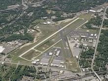
IATA: PDK – ICAO: KPDK Summary Airport type Public Operator DeKalb County Location DeKalb County, near Chamblee, Georgia Coordinates 33°52′32.2″N 84°18′07.1″W / 33.875611°N 84.301972°WCoordinates: 33°52′32.2″N 84°18′07.1″W / 33.875611°N 84.301972°W Runways Direction Length Surface ft m 2R/20L 6,000 1,829 Concrete 2L/20R 3,746 1,142 Asphalt 16/34 3,967 1,209 Asphalt 9/27 3,383 1,031 Asphalt Helipads Number Length Surface ft m H1 56 17 Concrete DeKalb-Peachtree Airport (IATA: PDK, ICAO: KPDK) is a municipal general aviation airport located in Chamblee, Georgia, just northeast of Atlanta. It is operated by the local government of DeKalb County, Georgia, and is also known commonly as Peachtree-DeKalb Airport, or simply PDK. Other names (rarely used) include Peachtree Airport, DeKalb Airport, or DeKalb County Airport. ASOS weather reports are produced 24 hours per day as "Chamblee".
Contents
History
The airport originally began during early World War II as Naval Air Station Atlanta, moved to Marietta on the south side of Dobbins Air Reserve Base until it was closed in 2009. The property was part of Camp Gordon, a World War I era training camp. Leased from the county by the United States Navy, it was converted from military to civilian use from 1957 to 1959. The former barracks located there during the war became classrooms in late 1948 for Southern Technical Institute, a new engineering technology school created by Georgia Tech for former soldiers. Like NAS Atlanta, that school moved around 1958 to land donated by Dobbins, and is now known as Southern Polytechnic State University.[1] In 1973 it was the site of a Learjet crash.
Facilities
The airport still has 765 acres (3.10 km2) of land, with over 100 hangars and several hundred aircraft based there. It is the second-busiest airport in Georgia behind Hartsfield-Jackson Atlanta International Airport in the number of flight operations per year (around 250,000), and helps to relieve ATL of smaller-airplane traffic. It also has a helipad, used by helicopters for metro Atlanta's four major news TV stations (WSB-TV 2, WAGA-TV 5, WXIA-TV 11, WGCL-TV 46) as the base for electronic news gathering from the air. PDK is also home to The AutoPILOT Magazine, an advertorial publication covering all things aviation-related. A new control tower was built in 1988, and stands at 130 feet (40 m) tall. The main runway (20L) is 6,000 feet (1,800 m) long.
Economic impact
DeKalb Peachtree Airport occupies a prime location inside the Perimeter, located less than fifteen minutes from Atlanta's major business centers in Buckhead and Midtown.[2] This proximity drives the 600 operations logged daily by the airport which makes it the second busiest in the state of Georgia behind Hartsfield-Jackson International Airport, the world's busiest, located eighteen miles (29 km) away.
In 1997, DeKalb Peachtree Airport was one of the largest tax contributors of DeKalb County, behind The Southern Company and Bellsouth but receives no taxpayer dollars for operations. The 1997 study found that in addition to 762 aviation-related jobs at the airport, there were indirect benefits of $14 million in annual visitor spending as well as 3,600 non-airport jobs driven by airport activities.[2]
While not primarily driven by the airport, a 30-acre (120,000 m2) mixed-use project called International Village is under development near the airport with a planned completion date of 2009. The previously residential property was purchased by Dekalb County as part of a noise mitigation buyout and ultimately sold to the developer, PDK Investments, LLC, in 2005.[3] The project name references the cultural and ethnic diversity of the surrounding neighborhoods and the Buford Highway corridor. The development is slated for a mix of low- and mid-rise commercial and retail space and will also host a boutique hotel and conference center as well as an amphitheater and green space for community festivals.[2]
Air Carriers and Destinations
Airlines Destinations Pet Airways Baltimore, Fort Lauderdale ImagineAir Air Taxi Eastern United States References
- ^ Duguay, J. C. (June 2000). "DeKalb Peachtree Airport - Our History". DeKalb Peachtree Airport. http://www.pdkairport.org/history.asp. Retrieved 2007-10-24.
- ^ a b c Glier, Ray (2007-10-19). "DeKalb Peachtree proves to be economic driver". Atlanta Business Chronicle. http://www.bizjournals.com/atlanta/stories/2007/10/22/focus30.html?b=1193025600^1536683&page=1. Retrieved 2007-10-24.
- ^ Prophet, Tatiana (2005-03-05). "'Village' to rise at DeKalb airport". Atlanta Business Chronicle. http://www.bizjournals.com/atlanta/stories/2005/03/28/story7.html?jst=s_cn_hl. Retrieved 2007-10-24.
External links
- DeKalb-Peachtree Airport (official site)
- Air Rail connection results for DeKalb Peachtree Airport from Airport Railways of the World (English)
- PDK Runway Incursions
- PDK Watch (Community watchdog organization monitoring PDK Airport)
- Open Dekalb, Inc. (Community organization- Brought legal action against PDK and DeKalb County, GA for failure to disclose PDK Airport public records)
- Resources for this airport:
- AirNav airport information for KPDK
- ASN accident history for PDK
- FlightAware airport information and live flight tracker
- NOAA/NWS latest weather observations
- SkyVector aeronautical chart, Terminal Procedures for KPDK
Airports of metro Atlanta Commercial Hartsfield–Jackson Atlanta International Airport (ATL)General aviation Cobb County Airport (RYY) • Cherokee County Airport (CNI) • Clayton County Airport (4A7) • Cartersville Airport (VPC) • Gwinnett County Airport (LZU) • Newnan-Coweta County Airport (CCO) • DeKalb-Peachtree Airport (PDK) • Fulton County Airport (FTY) • Paulding County Regional Airport (PUJ) • Falcon Field (FFC)Military Private Mathis Airport (GA27)Closed Stone Mountain Airport (00A)Categories:- Airports in Georgia (U.S. state)
- Buildings and structures in DeKalb County, Georgia
- Transportation in DeKalb County, Georgia

Wikimedia Foundation. 2010.